Lok Kawi

Last updated

Lok Kawi is a township in the West Coast Division of Sabah, Malaysia. Located around the border of the districts of Penampang and Papar, and about 15 kilometres south of the state capital Kota Kinabalu, it has become part of the urban expanse of Kota Kinabalu. Nearby towns include Putatan in the north, and Kinarut in the south.

West Coast Division

West Coast Division is an administrative division of Sabah, Malaysia. It occupies the northwest portion of Sabah. With an area of 7,588 square kilometres, it occupies 10.3% of Sabah's territory. It also has approximately 30% of Sabah's total population, with the main indigenous inhabitants comprising the Bajau, Bruneian Malay, Dusun, Illanun, Kadazan and Kedayan, as well with a significant numbers of Chinese. The division is divided into the districts of Ranau, Kota Belud, Tuaran, Penampang, Papar, and the state capital Kota Kinabalu. The main towns are as in the names of the districts, plus other towns including Putatan, Inanam, Telipok, Tamparuli, and Kinarut.
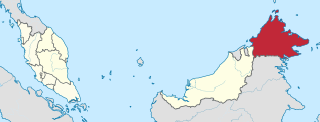
Sabah State of Malaysia

Sabah is a state of Malaysia located on the northern portion of Borneo. Sabah has land borders with the Malaysian state of Sarawak to the southwest and Indonesia's Kalimantan region to the south. The Federal Territory of Labuan is an island just off the Sabah coast. Sabah shares maritime borders with Vietnam to the west and the Philippines to the north and east. Kota Kinabalu is the state capital city, the economic centre of the state and the seat of the Sabah state government. Other major towns in Sabah include Sandakan and Tawau. As of the 2015 census in Malaysia, the state's population is 3,543,500. Sabah has an equatorial climate with tropical rainforests and abundant animal and plant species. The state has long mountain ranges on the west side which form part of the Crocker Range National Park. Kinabatangan River, second longest river in Malaysia runs through Sabah and Mount Kinabalu is the highest point of Sabah as well as of Malaysia.
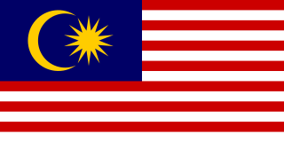
Malaysia Federal constitutional monarchy in Southeast Asia

Malaysia is a country in Southeast Asia. The federal constitutional monarchy consists of 13 states and three federal territories, separated by the South China Sea into two similarly sized regions, Peninsular Malaysia and East Malaysia. Peninsular Malaysia shares a land and maritime border with Thailand and maritime borders with Singapore, Vietnam, and Indonesia. East Malaysia shares land and maritime borders with Brunei and Indonesia and a maritime border with the Philippines and Vietnam. Kuala Lumpur is the national capital and largest city while Putrajaya is the seat of federal government. With a population of over 30 million, Malaysia is the world's 44th most populous country. The southernmost point of continental Eurasia, Tanjung Piai, is in Malaysia. In the tropics, Malaysia is one of 17 megadiverse countries, with large numbers of endemic species.

Originally a small village, Lok Kawi now features a small industrial estate as well a modern residential development. It is also the site for the Lok Kawi Army Camp (Kem Tentera Lok Kawi) and the Lok Kawi Wildlife Park. [1] Lok Kawi also features one of the few Hindu temples in Kota Kinabalu, the Sri Subramaniyar Temple.

In the 1920s, the author W. Somerset Maugham was a frequent visitor to Lok Kawi: his niece was married to the manager of Lok Kawi Estate. [2]

W. Somerset Maugham British playwright, novelist, short story writer

William Somerset Maugham, CH, better known as W. Somerset Maugham, was a British playwright, novelist and short story writer. He was among the most popular writers of his era and reputedly the highest-paid author during the 1930s.

Related Research Articles

Kota Kinabalu City and State Capital in Sabah, Malaysia

Kota Kinabalu, formerly known as Jesselton, is the state capital of Sabah, Malaysia and the capital of the Kota Kinabalu District. It is also the capital of the West Coast Division of Sabah. The city is located on the northwest coast of Borneo facing the South China Sea. The Tunku Abdul Rahman National Park lies to its west and Mount Kinabalu, which gave the city its name, is located to its east. Kota Kinabalu has a population of 452,058 according to the 2010 census; when the adjacent Penampang and Putatan districts are included, the metro area has a combined population of 628,725.

Likas Stadium

Likas Stadium is a stadium in Likas, Kota Kinabalu, Sabah, Malaysia. It is mainly used for association football and athletics and it is located within Likas Sports Complex. Likas Stadium has a capacity of 35,000, making it the 8th largest football stadium in Malaysia in terms of seating capacity.

Papar, Malaysia District Capital in Sabah, Malaysia

Papar is the capital of the Papar District in the West Coast Division of Sabah, Malaysia. Its population was estimated to be around 5,984 in 2010, which divided between Bruneian Malay, Kadazan-Dusun, and Bajau. There is also a sizeable Chinese minority, predominantly of the Hakka subgroup, as well as smaller numbers of other races. The town is located 38 kilometres south of the state capital of Kota Kinabalu, with the Papar railway station in the town become one of the main stops of the Sabah State Railway.

The Rafflesia Forest Reserve covers an area of 356 ha of Tambunan district, Sabah, Malaysia. It was established in 1984 by the Sabah Forestry Department to protect the Rafflesia flowers abundant in the area.

Mesilau

Mesilau, named after Mesilau River, is an area situated at approximately 2000 m above sea level on the East Ridge of Mount Kinabalu in Kinabalu National Park, Sabah, Malaysian Borneo. It is the site of the Mesilau Nature Resort, which is owned and operated by Sutera Sanctuary Lodges.

Kota Kinabalu City Mosque mosque in Malaysia

The Kota Kinabalu City Mosque is the second main mosque in Kota Kinabalu, Sabah, Malaysia, after State Mosque in Sembulan. The head imam is Ustaz Suhaidi Kuanting.

Tanjung Aru is a sub-district of Kota Kinabalu in Sabah, of Malaysia. Its main feature is its beach called Tanjung Aru Beach which stretches to over 2 kilometres long along with new skyscrapers.

Universiti Malaysia Sabah university in Malaysia

Universiti Malaysia Sabah is the ninth Malaysian public university located in Kota Kinabalu, Sabah, Malaysia, established on 24 November 1994.

SMS Sabah

Sekolah Menengah Sains Sabah is a fully residential school established in Malaysian state of Sabah. As the first fully residential school in East Malaysia and the 27th of its kind in Malaysia, SMESH was previously known as Sekolah Berasrama Penuh Sabah (SBPS). SMESH was established in 1978 but became fully operational on 1 January 1984. It has a 16-acre (65,000 m2) permanent campus in Bukit Padang, Kota Kinabalu. Due to the unsafe state of the campus, SMESH is temporarily operated in a temporary campus in Tuaran.

Sabah Museum

The Sabah Museum is the state museum of Sabah, Malaysia. It is sited on 17 ha of land at Bukit Istana Lama in Kota Kinabalu, the state capital. The complex contains not only the museum proper, but also an ethnobotanic garden, a zoo and a heritage village. The main building also houses the Sabah Art Gallery. Other galleries cover Islamic civilisation, archaeology and history, natural History, and ceramics and Brassware. The mission of the museum is to collect, preserve, conserve and document ethnographic, archaeological, historical, numismatic, art-historical, botanical, zoological and mineralogical collections from throughout the state, and to conduct research on important and interesting aspects of Sabah's history, culture, and social and natural history.

Greater Kota Kinabalu

Greater Kota Kinabalu refers to the urbanised areas surrounding the city of Kota Kinabalu in Malaysia. Kota Kinabalu is the capital of the state of Sabah and is the largest city in the state. The contiguous built-up urban agglomeration around Kota Kinabalu extends beyond the city boundary on the south side and into the district of Penampang. and to a lesser but growing extent into the districts of Papar (south) as well as Tuaran, Kota Belud and Ranau (north).

Perdana Park is a recreational park in Tanjung Aru, Kota Kinabalu, Sabah, Malaysia.

Tun Fuad Stephens Park is a recreational park in Bukit Padang, Kota Kinabalu, Sabah, Malaysia. It is built in honour of the late Chief Minister of Sabah Fuad Stephens who perished in the Double Six Tragedy in 1976.

Sabah Art Gallery

The Sabah Art Gallery is an art gallery in Kota Kinabalu, Sabah, Malaysia.

Kota Kinabalu District District in Sabah, Malaysia

The Kota Kinabalu District is an administrative district in the Malaysian state of Sabah, part of the West Coast Division which includes the districts of Kota Belud, Kota Kinabalu, Papar, Penampang, Putatan, Ranau and Tuaran. The capital of the district is in Kota Kinabalu City.

Penampang District District in Sabah, Malaysia

The Penampang District is an administrative district in the Malaysian state of Sabah, part of the West Coast Division which includes the districts of Kota Belud, Kota Kinabalu, Papar, Penampang, Putatan, Ranau and Tuaran. The capital of the district is in Penampang Town.

Putatan District District in Sabah, Malaysia

The Putatan District is an administrative district in the Malaysian state of Sabah, part of the West Coast Division which includes the districts of Kota Belud, Kota Kinabalu, Papar, Penampang, Putatan, Ranau and Tuaran. The capital of the district is in Putatan Town.

Merdeka Square, Kota Kinabalu

Merdeka Square is a square located in Kota Kinabalu, Sabah, Malaysia. The square has a capacity of around 5,000.

References

  1. "Army strength in Sabah at the optimum level". Daily Express. 9 September 2015. Archived from the original on 24 September 2015. Retrieved 15 March 2017.
  2. Firkins, Peter (1995) Borneo Surgeon: A Reluctant Hero. The Story of Dr James P Taylor Carlisle, Western Australia: Hesperian Press. ISBN   0-85905-211-7, 32

Coordinates: 5°51′N116°03′E / 5.850°N 116.050°E / 5.850; 116.050

Geographic coordinate system Coordinate system

A geographic coordinate system is a coordinate system that enables every location on Earth to be specified by a set of numbers, letters or symbols. The coordinates are often chosen such that one of the numbers represents a vertical position and two or three of the numbers represent a horizontal position; alternatively, a geographic position may be expressed in a combined three-dimensional Cartesian vector. A common choice of coordinates is latitude, longitude and elevation. To specify a location on a plane requires a map projection.