Borneo is the third-largest island in the world, with an area of 748,168 km2 (288,869 sq mi). Situated at the geographic centre of Maritime Southeast Asia, it is one of the Greater Sunda Islands, located north of Java, west of Sulawesi, and east of Sumatra.

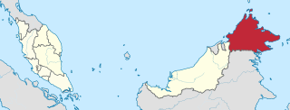
Sabah is a state of Malaysia located on the northern portion of Borneo, in the region of East Malaysia. Sabah has land borders with the Malaysian state of Sarawak to the southwest and Indonesia's North Kalimantan province to the south. The Federal Territory of Labuan is an island just off Sabah's west coast. Sabah shares maritime borders with Vietnam to the west and the Philippines to the north and east. Kota Kinabalu is the state capital and the economic centre of the state, and the seat of the Sabah State government. Other major towns in Sabah include Sandakan and Tawau. The 2020 census recorded a population of 3,418,785 in the state. It has an equatorial climate with tropical rainforests, abundant with animal and plant species. The state has long mountain ranges on the west side which forms part of the Crocker Range National Park. Kinabatangan River, the second longest river in Malaysia runs through Sabah. The highest point of Sabah, Mount Kinabalu is also the highest point of Malaysia. While internationally recognised as Malaysian territory, the Philippines maintains a dormant claim on the eastern portion of Sabah, on the basis that it was historically territory of the Sultanate of Sulu.

East Malaysia, or the Borneo States, also known as Malaysian Borneo, is the part of Malaysia on and near the island of Borneo, the world's third-largest island. East Malaysia comprises the states of Sabah, Sarawak, and the Federal Territory of Labuan. The small independent nation of Brunei comprises two enclaves in Sarawak. To the south and southeast is the Indonesian portion of Borneo, Kalimantan. East Malaysia lies to the east of Peninsular Malaysia, the part of the country on the Malay Peninsula. The two are separated by the South China Sea.

The geography of Malaysia includes both the physical and the human geography of Malaysia, a Southeast Asian country made up of two major landmasses separated by water—Peninsular Malaysia to the West and East Malaysia to the East—and numerous smaller islands that surround those landmasses. Peninsular Malaysia is on the southernmost part of the Malay Peninsula, south of Thailand, north of Singapore and east of the Indonesian island of Sumatra; East Malaysia comprises most of the northern part of Borneo island, and shares land borders with Brunei to the north and Indonesian Borneo to the south.

Sandakan formerly known at various times as Elopura, is the capital of the Sandakan District in Sabah, Malaysia. It is the second largest city in Sabah after Kota Kinabalu. It is located on the Sandakan Peninsula and east coast of the state in the administrative centre of Sandakan Division and was the former capital of British North Borneo. In 2010, the city had an estimated population of 157,330 while the overall municipal area had a total population of 396,290. The population of the municipal area had increased to 439,050 by the 2020 Census.

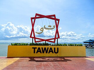
Tawau, formerly known as Tawao, is the capital of the Tawau District in Sabah, Malaysia. It is the third-largest city in Sabah, after Kota Kinabalu and Sandakan. It is located on the Semporna Peninsula in the southeast coast of the state in the administrative centre of Tawau Division, which is bordered by the Sulu Sea to the east, the Celebes Sea to the south at Cowie Bay and shares a border with North Kalimantan, Indonesia. The town had an estimated population as of 2010, of 113,809, while the whole municipality area had a population of 397,673. The municipal area had a population of 372,615 at the 2020 Census.

The Kinabatangan River is a river in Sandakan Division, in northeastern Sabah, Malaysia. It is the second longest river in Malaysia, with a length of 560 km (350 mi) from its headwaters in the mountains of southwest Sabah to its outlet at the Sulu Sea, east of Sandakan. The area is known for its high biodiversity, including its limestone caves at Gomantong Hill, dryland dipterocarp forests, riverine forest, freshwater swamp forest, oxbow lakes, and salty mangrove swamps near the coast.

The North Borneo Chartered Company (NBCC), also known as the British North Borneo Company (BNBC) was a British chartered company formed on 1 November 1881 to administer and exploit the resources of North Borneo. The territory became a protectorate of the British Empire in 1888 but the company remained involved with the territory until 1946, when administration was fully assumed by the Crown colony government.

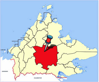
Sandakan Division is an administrative division of Sabah, Malaysia. It stretches diagonally from the northeastern coast of Sabah to the state's central region. With an area of 28,205 square kilometres, it occupies 38.3% of Sabah's territory, and is thus the largest of the five administrative divisions of Sabah. It also has approximately 19.4% of Sabah's total population, with the major inhabitants comprising the Chinese, Orang Sungai, Kadazan-Dusun, Suluk and Bajau Simunul.

The history of Sabah can be traced back to about 23–30,000 years ago when evidence suggests the earliest human settlement in the region existed. The history is interwoven with the history of Brunei and the history of Malaysia, which Sabah was previously part of and is currently part of respectively. The earliest recorded history of Sabah being part of any organised civilisation began in the early 15th century during the thriving era of the Sultanate of Brunei. Prior to this, early inhabitants of the land lived in predominantly tribal societies, although such tribal societies had continued to exist until the 1900s. The eastern part of Sabah was ceded to the Sultan of Sulu by the Sultan of Brunei in 1658 for the former helping a victory over Brunei enemies, but many sources stated it had not been ceded at all. By the late 19th century, both territories previously owned by Sultan of Brunei and Sultan of Sulu was granted to British syndicate and later emerged as British North Borneo under the management of the North Borneo Chartered Company. Sabah became a protectorate of the United Kingdom in 1888 and subsequently became a Crown colony from 1946 until 1963, during which time it was known as Crown Colony of North Borneo. On 16 September 1963, Sabah merged with Malaya, Sarawak and Singapore to form Malaysia.

Datuk Seri Panglima Bung Moktar bin Radin is a Malaysian politician and lawyer who has served as the Member of Parliament (MP) for Kinabatangan since November 1999 and Member of the Sabah State Legislative Assembly (MLA) for Lamag since September 2020. He served as the Deputy Chief Minister I, State Minister of Works of Sabah from September 2020 to January 2023, Chairman of FELCRA Berhad from 2013 to 2018 and Deputy Chairman of the Barisan Nasional Backbenchers Club (BNBBC) from 2008 to 2018. He is a member of the United Malays National Organisation (UMNO), a component party of the Barisan Nasional (BN) coalition. He has also served as the State Chairman of BN and UMNO of Sabah since December 2018. He is a former member of United Sabah National Organisation (USNO).

The Chartered Company Monument is a monument in the town of Sandakan in Sabah, Malaysia dedicated to the British servicemen or employees who were killed at the end of the 19th century. The monument was built by the British North Borneo Company and part of the Sandakan Heritage Trails, a trail which connects the historic sights of Sandakan.

Agop Batu Tulug Caves is an archaeological site in the Malaysian state of Sabah and refers to a group of several caves in a steep limestone cliffs in the Kinabatangan district.

Sabah is the third most populous state in Malaysia, with a population of 3,418,785 according to the 2020 Malaysian census. It also has the highest non-citizen population, at 810,443. Although Malaysia is one of the least densely populated countries in Asia, Sabah is particularly sparsely populated. Most of the population is concentrated along coastal areas, with towns and urban centers seeing the most population growth.

The Sipitang District is an administrative district in the Malaysian state of Sabah, part of the Interior Division which also includes the districts of Beaufort, Keningau, Kuala Penyu, Nabawan, Tambunan and Tenom. The capital of the district is in Sipitang Town. The ecotourism village of Long Mio and Long Pasia is located in this district, while the small town of Sindumin serves as a gateway to the state of Sarawak.

The Beluran District is an administrative district in the Malaysian state of Sabah, part of the Sandakan Division which includes the districts of Beluran, Kinabatangan, Sandakan, Telupid and Tongod. The capital of the district is in Beluran Town.

The Sandakan District is an administrative district in the Malaysian state of Sabah, part of the Sandakan Division which includes the districts of Beluran, Kinabatangan, Sandakan, Telupid, and Tongod. The capital of the district is in Sandakan City.

The Tongod District is an administrative district in the Malaysian state of Sabah, part of the Sandakan Division which includes the districts of Beluran, Kinabatangan, Sandakan, Telupid and Tongod. The capital of the district is in Tongod Town.

The Telupid District is an administrative district in the Malaysian state of Sabah, part of the Sandakan Division which includes the districts of Beluran, Kinabatangan, Sandakan and Tongod. The capital of the district is in Telupid Town. The district is formerly a part of Beluran District.

Sandakan Heritage Museum is a museum located at the 1st floor of Wisma Warisan building in Sandakan of Sabah, Malaysia. The museum building is located next to the Sandakan Municipal Council and is part of the Sandakan Heritage Trail.


