Kuala Muda District

Last updated
Kuala Muda District
Daerah Kuala Muda
Other transcription(s)
   Jawi كوالا مودا
   Chinese 瓜拉姆达县
   Tamil கோலா மூடா
Kuala Muda highlighted in Kedah, Malaysia.svg
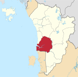
Location of Kuala Muda District in Kedah
Kuala Muda District
Malaysia location map with districts.svg
Red pog.svg
Kuala Muda District
Location of Kuala Muda District in Malaysia
Coordinates: 5°40′N100°30′E / 5.667°N 100.500°E / 5.667; 100.500
Country Flag of Malaysia.svg  Malaysia
State Flag of Kedah.svg  Kedah
Seat Sungai Petani
Local area government(s) Sungai Petani Municipal Council
Government
  District officerMd Shuhaime Abdul Rahman
Area
[1]
  Total928.35 km2 (358.44 sq mi)
Population
 (2020 [2] )
  Total521,200
  Density560/km2 (1,500/sq mi)
Time zone UTC+8 (MST)
  Summer (DST) UTC+8 (Not observed)
Postcode
09xxx
Calling code +6-044
Vehicle registration plates K

The Kuala Muda District is a district in Kedah, Malaysia. Sungai Petani is the administrative center of the district. Kuala Muda district is in close proximity to the border of Kedah and Penang. Apart from Sungai Petani, other major towns in the district include Tikam Batu, Padang Tembusu, Sungai Lalang, Bedong, Bukit Selambau, Sidam, Gurun, Semeling, Merbok, Kota Kuala Muda and Tanjung Dawai. The Mount Jerai is shared with the neighbouring district of Yan while the Muda River is shares the bordering state of Penang. The iconic Jambatan Merdeka (Independent Bridge) connect both Tikam Batu with Bumbung Lima in Penang. Kuala Muda is the second largest and most populous district in Kedah, and it is also the site of some of the earliest civilization site in the country.

Contents

History

The name Kuala Muda may derived from the river that cut cross the southern part of Kedah, Sungai Muda (Muda River) which meets the Strait of Melaka in the fishing village of Kampung Sungai Muda, Kota Kuala Muda. Confluences of the river were also part of the Kedah history; Sungai Merbok and Sungai Mas harboured among the earliest civilization in the country, Sungai Sungai Petani, Sungai Semeling and Sungai Ketil. Ancient ruins and artifacts can be found across the districts, from temple-like structures or candis, the Kota Kuala Muda Gates, ancient boats called Perahu Sagor, glass beads, Buddhist and Hindu statues and potteries.

The district suffered from the 2004 tsunami which caused 11 casualties. [3]

Map of Kuala Muda District Map of Kuala Muda District, Kedah.svg
Map of Kuala Muda District

Administrative divisions

Kuala Muda District is divided into 16 mukims, which are: [4]

Demographics

Historical population
YearPop.±%
1991 254,372    
2000 339,898+33.6%
2010 443,488+30.5%
2020 544,984+22.9%
Source: [5]

Federal Parliament and State Assembly Seats


List of Kuala Muda district representatives in the Federal Parliament (Dewan Rakyat)

ParliamentSeat NameMember of ParliamentParty
P12 Jerai Sabri bin Azit Perikatan Nasional (PAS)
P14 Merbok Mohd Nazri Abu Hassan Perikatan Nasional (BERSATU)
P15 Sungai Petani Mohammed Taufiq Johari Pakatan Harapan (PKR)


List of Kuala Muda district representatives in the State Legislative Assembly (Dewan Undangan Negeri)

ParliamentStateSeat NameState AssemblymanParty
P12N22 Gurun Baddrol Bakhtiar Perikatan Nasional(PAS)
P14N25 Bukit Selambau Azizan Hamzah Perikatan Nasional (PAS)
P14N26 Tanjung Dawai Hanif Bin Ghazali Perikatan Nasional (PAS)
P15N27 Pantai Merdeka Shahrir Long Perikatan Nasional ((PAS))
P15N28 Bakar Arang Adam Loh Wei Chai Pakatan Harapan (PKR)
P15N29 Sidam Bau Wong Bau Ek Pakatan Harapan (PKR)

See also

Related Research Articles

<span class="mw-page-title-main">Kedah</span> State of Malaysia

Kedah, also known by its honorific Darul Aman and historically as Queda, is a state of Malaysia, located in the northwestern part of Peninsular Malaysia. The state covers a total area of over 9,000 km2, and it consists of the mainland and the Langkawi islands. The mainland has a relatively flat terrain, which is used to grow rice, while Langkawi is an archipelago, most of which are uninhabited islands.

<span class="mw-page-title-main">Sungai Petani</span> Town and district capital in Kedah, Malaysia

Sungai Petani is a town in Kuala Muda District, Kedah, Malaysia. Sungai Petani is Kedah's largest city and is located about 55 km south of Alor Setar, the capital of Kedah, and 33 km northeast of George Town, the capital city of the neighbouring state of Penang.

<span class="mw-page-title-main">Alor Setar</span> State capital of Kedah, Malaysia

Alor Setar is the state capital of Kedah, Malaysia. It is the second-largest city in the state after Sungai Petani and one of the most-important cities on the west coast of Peninsular Malaysia. It is home to the third-tallest telecommunication tower in Malaysia, the Alor Setar Tower.

<span class="mw-page-title-main">Baling District</span> District of Malaysia in Kedah

The Baling District is an administrative district in southeastern Kedah, Malaysia. Located about 110 km from Alor Setar, it borders Perak and Betong, the southernmost town of Thailand.

<span class="mw-page-title-main">Mount Jerai</span> Mountain in Kedah, Malaysia

Mount Jerai, formerly Kedah Peak, is a mountain in Kedah, Malaysia with the height of 3,993 feet (1,217 m). Within Kedah itself, the mountain stands at the border of Kuala Muda and Yan districts.

<span class="mw-page-title-main">Kedah Sultanate</span> Sultanate in the Malay Peninsula

The Kedah Sultanate is a Muslim dynasty located in the Malay Peninsula. It was originally an independent state, but became a British protectorate in 1909. Its monarchy was abolished after it was added to the Malayan Union but was restored and added to the Malayan Union's successor, the Federation of Malaya.

<span class="mw-page-title-main">Merbok</span>

Merbok is a mukim in Kuala Muda District, Kedah, Malaysia. The historical Bujang Valley is located here. It is also the location for the Universiti Teknologi MARA Kedah Campus.

<span class="mw-page-title-main">Bandar Baharu District</span> District of Malaysia in Kedah

The Bandar Baharu District is a town, district and state assembly constituency at the southernmost end of Kedah, Malaysia. Bandar Baharu is located along the Kedah-Penang–Perak border tripoint, 37 km (23 mi) southeast of George Town, Penang's capital city.

<span class="mw-page-title-main">Yan District</span> District of Malaysia in Kedah

The Yan District is a district in Kedah, Malaysia. It is bordered by Kota Setar District to the north, Pendang District to the northeast and Kuala Muda District to the south. Yan District is along the coast of the Straits of Malacca. It is the smallest municipality in Kedah.

<span class="mw-page-title-main">Muda River</span> River in Kedah, Malaysia

The Muda River is the longest river in Kedah, Malaysia.

<span class="mw-page-title-main">Kota Setar District</span> District of Malaysia in Kedah

The Kota Setar District is a district in Kedah, Malaysia where the state capital Alor Star is situated.

<span class="mw-page-title-main">Larut, Matang and Selama District</span> District of Perak, Malaysia

The Larut, Matang and Selama District is a district of Perak, Malaysia. Taiping is the capital town of this district. Larut, Matang and Selama used to be three small different districts and they merged into one larger district later. Larut, Matang and Selama houses Taiping, Perak's second largest city and former state capital. Other towns in the region include Matang, Kuala Sepetang and Selama. The region borders the state of Kedah on the north, the Kerian District on the northwest, the Hulu Perak and Kuala Kangsar District on the east, and the Manjung District on the south.

<span class="mw-page-title-main">South Seberang Perai District</span> District of Malaysia in Penang

The South Seberang Perai District is a district in Penang, Malaysia. It covers an area of 242 square kilometres, and had a population of 184,007 at the 2020 Census. The district is bordered by Junjong River that separates Central Seberang Perai in the north, Kedah state border in the east, Perak state border in the south and the South Channel that separates Penang Island. Rivers that flow through South Seberang Perai are Junjong River, Jawi River and Kerian River. The capital of this district is Sungai Jawi and the largest town is Nibong Tebal. Other towns such as Batu Kawan, Bukit Tambun, Simpang Ampat, Sungai Bakap and Valdor are also located in this district. South Seberang Perai is thriving with the fishing industry and agriculture. Oil palm plantations covers most parts of the area.

<span class="mw-page-title-main">Pantai Merdeka</span> Beach in Kuala Muda, Kedah, Malaysia

Pantai Merdeka is a coastal location in Kuala Muda District, Kedah, Malaysia. It has the only sand beach in mainland Kedah, and it is the major attraction for beach goers from all over northern Penang and Kedah State. Various accommodation is available for rent to experience the beach and other attractions in the area which includes harvesting Kepah, Siput Kemudi and Kerang in Kampung Tepi Sungai, Kota Kuala Muda, Pantai Merdeka itself and also at Pulau Sayak.

<span class="mw-page-title-main">Sungai Lalang</span> Place in Kedah, Malaysia

Sungai Lalang is a small town in Kuala Muda District, Kedah, Malaysia. It is located 5 kilometer north from Sungai Petani. Sg. Lalang River situated in this town flows into the Merbok River.

<span class="mw-page-title-main">Johari Abdul</span> Malaysian politician

Johari bin Abdul is a Malaysian politician who has served as the 11th Speaker of the Dewan Rakyat since December 2022. He served as the State Leader of the Opposition of Kedah from October 2022 and Member of the Kedah State Legislative Assembly (MLA) for Gurun from May 2018 to his resignations in December 2022, the Member of Parliament (MP) for Sungai Petani from March 2008 and Chairman of the Pakatan Harapan Backbenchers Club (PHBBC) from August 2018 to November 2022 respectively. He is a member of the People's Justice Party (PKR), a component party of the Pakatan Harapan (PH) coalition.

<span class="mw-page-title-main">Sungai Petani Municipal Council</span>

Sungai Petani Municipal Council is the local government which administers Sungai Petani and the whole Kuala Muda District, Kedah, Malaysia. It is the most populous local government in Kedah.

<span class="mw-page-title-main">Teluk Air Tawar</span> Neighbourhood of Seberang Perai in Penang, Malaysia

Teluk Air Tawar is a residential neighbourhood within the city of Seberang Perai in the Malaysian state of Penang. Teluk Air Tawar means "Clear water bay" in the Malay language. This seaside town has a scenic view of George Town across the sea.

<span class="mw-page-title-main">Kuala Kangsar District</span> District in Perak, Malaysia

The Kuala Kangsar District is a district in Perak, Malaysia. Kuala Kangsar shares its borders with Larut, Matang and Selama at the west, Hulu Perak at the north, Gua Musang of Kelantan at the east, Kinta at the south, Perak Tengah and Manjung at the southwest. The seat of this district is the town of Kuala Kangsar.

References

  1. "Laman Web Rasmi Pejabat Daerah Kuala Muda - Sejarah Pentadbiran". pdkm.kedah.gov.my. Archived from the original on 2017-12-07. Retrieved 2017-11-26.
  2. "Kependudukan Negeri Kedah" (PDF). Department of Statistics Malaysia. Retrieved 4 June 2023.
  3. "Sembilan tahun menanti pembukaan Galeri Tsunami di Kota Kuala Muda" (in Malay). Utusan Online. 26 December 2015. Retrieved 2 March 2018.
  4. "PEJABAT DAERAH KUALA MUDA". pejabatdaerahkualamuda.blogspot.my. 28 February 2011.
  5. "Key Findings of Population and Housing Census of Malaysia 2020" (pdf) (in Malay and English). Department of Statistics, Malaysia. ISBN   978-967-2000-85-3.