Lundu, Sarawak

Last updated

Lundu
Landmark of Lundu town.svg
Landmark of Lundu town
The Seal of Lundu District Council.png
Malaysia location map.svg
Red pog.svg
Lundu
Coordinates: 1°40′0″N109°50′0″E / 1.66667°N 109.83333°E / 1.66667; 109.83333
Country Flag of Malaysia.svg  Malaysia
State Flag of Sarawak.svg  Sarawak
Division Kuching
District Lundu
Government
  Type Local government (Lundu District Council)
  District OfficerGustian bin Haji Durani
  Council SecretaryNorashikin binti Brahim
Area
  Total1,962.2 km2 (757.6 sq mi)
Population
 (2020) [1]
  Total39,200
  Density20/km2 (52/sq mi)
Time zone UTC+8 (MST)
  Summer (DST)Not observed
Area code 082
Website lundudc.sarawak.gov.my

Lundu is a town and the capital of Lundu District located in the northwest of Kuching Division of Sarawak, Malaysia, and borders the Indonesian Province of West Kalimantan.

Contents

History

Lundu is a district located in the Northwest of Kuching Division of Sarawak, Malaysia, and borders with Indonesian Province of West Kalimantan. Once upon a time, Lundu was a strategic area in the waters of Tanjung Datu that has been known for centuries in history, including in the history of Majapahit, China and Srivijaya. This was realized by the British colonialists when Lundu was later made the first stronghold.

As far as anyone knows, the lands around Lundu was empty of people until relatively recently. Although the main river is called Batang Kayan, "the Kayan river," there is no evidence at all that any Kayan people ever lived there. In the middle of the eighteenth century a group of Bidayuh people from near Bau migrated and settled on the west bank of the Batang Kayan, where Kampong Stunggang Melayu now stands. They came to be called the Dayak Lundu, and though the last member of the tribe died in the 1960s, you can still see the grove of durian trees they planted.

The name "Lundu" itself is taken from a small catfish that abounds in the Sungai Lundu which flows down from Gunung Gading. [2] There are also local sources said that Lundu name comes from community groups known as the Undu, but when mixing marriage with Malay, Bidayuh and Iban this community has group into Malay, Bidayuh and Iban. Undu is actually a variation of the name Undi or Datu Undi or known as Raja Jarom who comes from Minangkabau, Sumatra. Datu Undi or Undu has seven children. His children became the government in Saribas, Samarahan, Kalaka, Sadong. His children are very famous such as Dato Terawoh in Kota Samarahan and Datu Godam (Saribas) who use the title of Abang.

Towards the close of the eighteenth century three groups of people at the same time came separately to make their homes in Lundu. From the east came the Ibans. These Ibans were originally from Balau on the west bank of the Batang Lupar. As the Iban were coming to Lundu from the east, Chinese and Selako settlers were arriving from the west, over the hills that separate Sarawak from what is now Indonesian Borneo. Chinese had been living in Pontianak and Sambas for a hundred years or more. When gold was discovered in Bau, Chinese migrated there. Also from the west came the Selako or Selakau. Malays also came to settle from the Natuna Islands.

What is wonderful about Lundu, is that although four different people settled very close together, there has from the beginning never been any friction between them. They seek a better life, and each people pursued their aim in a way that did not compete with the others. Lundu had electricity and piped water (from Gunung Gading) by the early 60s. The Lundu hospital was built in 1965, and now offers treatment for all except the most serious problems. They have a dental clinic and ultrasound screening for mothers-to-be. Until 1968, Lundu could be reached from Kuching only by boat. The road from Bau to Lundu was completed in that year and regular bus service began.

Lundu is currently under constant development, with more and more public infrastructures and other being built and proposed.

Politics

In state and federal Constituencies, Lundu area is represented by Barisan Nasional:

Local government

Lundu District Office is the nerve center of the administration of the District. The first district officer was appointed in 1877 and the current district officer is the 44th. The district officer has wide statutory powers, to enable him to function effectively. The district officer is also chairman of the Lundu District Council.

Lundu District Council provides municipal services for Lundu District. The secretary to the Lundu District Council is the CEO. The early history of the Lundu District Council is just like other councils in Sarawak which was in 1953, chaired by D.L Bruen (1953-1956), which was then known as Lundu District Authority. On the 1 April 1957, the Lundu District Local Authority was re-established and known as Lundu District Council until the restructuring of Local Councils in 1981 till today to handle the management and administrative duties of the Lundu District.

The Lundu District Council Office is located at the Batang Kayan Road, near the town of Lundu, opposite the Batang Kayan river. There are 32 council members including Chairman and Deputy Chairman appointed as Council Member by His Excellency's Speaker of the State of Sarawak to perform all the obligations entrusted to the people.

Transportation

Local Bus

Route No.Operating RouteOperatorRemark
K26Kuching-Bau-Lundu-SematanCPL

Lundu is located 100 km from Kuching City, 70 km from Bau Town, 28 km from Sematan Bazzar, 26 km from Biawak Bazzar, 18 km from Kampong Sebako and 10 km from Pandan Beach. It is accessible by road. In the mid- to late-2000s, Batang Kayan Bridge was officially opened to traffic, ending the ferry services to and from Lundu through Batang Kayan. Lundu was previously connected by air, and there are remains of the former airstrip in Lundu. Part of the runway of the old airstrip is now used as a road.

Biawak which is near the Indonesia-Malaysia border is the location of one of three land border crossings into Indonesia. The Malaysian checkpoint is called the Biawak Immigration, Customs, Quarantine and Security Checkpoint while the Indonesian checkpoint is called the Aruk Border Crossing Checkpoint. The nearest towns to Aruk are Sambas town about 93m away, and Singkawang about 160 km away. Both towns are in West Kalimantan.

Education

Centre for Technology Excellence Sarawak (CENTEXS) set up a hospitality and tourism academy in Lundu in December 2022 to upskill and reskill school leavers, industry employees, and university graduates. [3]

Primary schools

Secondary schools

Climate

Lundu has a tropical rainforest climate (Af) with heavy to very heavy rainfall year-round and with extremely heavy rainfall in January and February.

Climate data for Lundu
MonthJanFebMarAprMayJunJulAugSepOctNovDecYear
Mean daily maximum °C (°F)29.3
(84.7)
29.6
(85.3)
30.6
(87.1)
31.5
(88.7)
31.9
(89.4)
31.6
(88.9)
31.6
(88.9)
31.4
(88.5)
31.2
(88.2)
31.2
(88.2)
30.8
(87.4)
30.2
(86.4)
30.9
(87.6)
Daily mean °C (°F)25.8
(78.4)
26.0
(78.8)
26.6
(79.9)
27.2
(81.0)
27.4
(81.3)
27.2
(81.0)
27.0
(80.6)
26.9
(80.4)
26.8
(80.2)
26.9
(80.4)
26.6
(79.9)
26.3
(79.3)
26.7
(80.1)
Mean daily minimum °C (°F)22.4
(72.3)
22.5
(72.5)
22.6
(72.7)
22.9
(73.2)
23.0
(73.4)
22.8
(73.0)
22.5
(72.5)
22.5
(72.5)
22.5
(72.5)
22.7
(72.9)
22.5
(72.5)
22.5
(72.5)
22.6
(72.7)
Average rainfall mm (inches)690
(27.2)
718
(28.3)
438
(17.2)
211
(8.3)
179
(7.0)
128
(5.0)
139
(5.5)
178
(7.0)
165
(6.5)
232
(9.1)
286
(11.3)
497
(19.6)
3,861
(152)
Source: Climate-Data.org [4]

Economic activities

Attractions and recreational spots

Sunrise over Siar beach. Sunrise over the clouds at Siar beach.jpg
Sunrise over Siar beach.
A chalet beside a small artificial lake garden inside Union Yes Retreat & Training Centre. Small lake garden inside Union Yes Retreat.jpg
A chalet beside a small artificial lake garden inside Union Yes Retreat & Training Centre.
Chalets at Salcra Bajo Training Centre. Salcra Bajo Training Centre chalets near Siar beach.jpg
Chalets at Salcra Bajo Training Centre.

Siar beach is located to the west of the Lundu town, within Pandan village. [5] Sarawak Land Consolidation & Rehabilitation Authority (SALCRA) Bajo training centre and Union Yes Retreat & Training Centre are located near the Siar beach. [6] [7] [8]

Related Research Articles

<span class="mw-page-title-main">Sarawak</span> A state of Malaysia

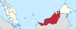
Sarawak is a state of Malaysia. The largest among the 13 states, with an area almost equal to that of Peninsular Malaysia, Sarawak is located in the region of East Malaysia in northwest Borneo, and is bordered by the Malaysian state of Sabah to the northeast, Kalimantan to the south, and Brunei in the north. The capital city, Kuching, is the largest city in Sarawak, the economic centre of the state, and the seat of the Sarawak state government. Other cities and towns in Sarawak include Miri, Sibu, and Bintulu. As of the 2020 Malaysia census, the population of Sarawak was 2.453 million. Sarawak has an equatorial climate with tropical rainforests and abundant animal and plant species. It has several prominent cave systems at Gunung Mulu National Park. Rajang River is the longest river in Malaysia; Bakun Dam, one of the largest dams in Southeast Asia, is located on one of its tributaries, the Balui River. Mount Murud is the highest point in the state. Sarawak is the only state of Malaysia with a Christian majority.

<span class="mw-page-title-main">Kuching</span> City and state capital in Sarawak, Malaysia

Kuching, officially the City of Kuching, is the capital and the most populous city in the state of Sarawak in Malaysia. It is also the capital of Kuching Division. The city is on the Sarawak River at the southwest tip of the state of Sarawak on the island of Borneo and covers an area of 431 km2 (166 sq mi) with a population about 165,642 in the Kuching North administrative region and 159,490 in the Kuching South administrative region—a total of 325,132 people.

<span class="mw-page-title-main">Serian Division</span> Town in Sarawak, Malaysia

Serian is a town, and the capital of the Serian separated on 11 April 2015 from Samarahan Division, Sarawak, Malaysia. It is located about 40 miles (64 km) from Kuching. Sub-district headquarters towns are Balai Ringin and Tebedu.

<span class="mw-page-title-main">Iban people</span> Ethnic group from Borneo

The Ibans or Sea Dayaks are an Austronesian ethnic group indigenous to northwestern Borneo. The Ibans are also known as Sea Dayaks and the title Dayak was given by the British and the Dutch to various ethnic groups in Borneo island.

<span class="mw-page-title-main">Bidayuh</span> Ethnic group from Borneo

Bidayuh is the collective name for several indigenous groups found in southern Sarawak, Malaysia and northern West Kalimantan, Indonesia, on the island of Borneo, which are broadly similar in language and culture. The name Bidayuh means 'inhabitants of land'. Originally from the western part of Borneo, the collective name Land Dayak was first used during the period of Rajah James Brooke, the White Rajah of Sarawak. At times, they were also lesser referred to as Klemantan people. They constitute one of the main indigenous groups in Sarawak and West Kalimantan and live in towns and villages around Kuching and Serian in the Malaysian state of Sarawak, while in the Indonesian province of West Kalimantan they are mainly concentrated in the northern Sanggau Regency. In Sarawak, most of Bidayuh population can be found within 40 km of the geographical area known as Greater Kuching, within the Kuching and Serian Division. They are the second-largest Dayak ethnic group in Sarawak after the Iban and one of the major Dayak tribes in West Kalimantan.

<span class="mw-page-title-main">Royal Ranger Regiment</span> Military unit

The Royal Ranger Regiment is an infantry regiment of the Malaysian Army. Although it is second in seniority to the Royal Malay Regiment, the RRD can trace its origins back to the mid 19th century and the establishment of The Sarawak Rangers, the peacekeeping force in the Sarawak region. This force was absorbed by the Sarawak Constabulary in 1932, but the name was revived in 1941 as a British Colonial unit; this unit commanded by British Lieutenant Colonel C.M. Lane was captured by the Japanese in 1942.

<span class="mw-page-title-main">Song, Malaysia</span> Town and district capital in Sarawak, Malaysia

Song is a town, and the capital of the Song District in Kapit Division, Sarawak, Malaysia. The district population was 20,046 according to the 2010 census. Song is situated by the banks of the Katibas River, a tributary of the Rajang River. It is an important stopover for river traffic going up the Rajang River.

<span class="mw-page-title-main">Betong, Sarawak</span> Town in Betong Division in Sarawak, Malaysia

Betong is a town in Betong Division in Sarawak, Malaysia, lying in the Saribas area. It was formerly under the Sri Aman district. Betong is located between three main rivers, Batang Lupar, Batang Saribas and Batang Kelaka, and covers an area of 4,180 km2.

<span class="mw-page-title-main">Kuching Division</span> Place

Kuching Division is one of the twelve administrative divisions in Sarawak, Malaysia. Formerly part of what was called the "First Division", it is the center and the starting point of modern Sarawak. Kuching Division has a total area of 4,559.5 square kilometres.

<span class="mw-page-title-main">Bau, Sarawak</span> Town and district capital in Sarawak, Malaysia

Bau is a gold mining town, capital of Bau district in the Kuching Division of Sarawak, Malaysia.

<span class="mw-page-title-main">Mount Pueh</span> Mountain in Malaysia

Mount Pueh, also known as Mount Pueh-Berumput, Mount Poi and Mount Poe, is a mountain located near Lundu, Sarawak on the Malaysia-Indonesia border. Mount Pueh was known to biologists for the collections made there by Eric Mjöberg (1882–1938), a Swedish naturalist, who was Curator of the Sarawak Museum between 1922 and 1924. Mjöberg's herpetological collections from Gunung Pueh between October and December 1923, and other localities in Borneo, were reported by Smith (1925). Mjöberg, unfortunately, left little by way of written records, of his ascent of Pueh and the collections he made.

<span class="mw-page-title-main">History of Sarawak</span> Aspect of history

The History of Sarawak can be traced as far as 40,000 years ago to the paleolithic period where the earliest evidence of human settlement is found in the Niah caves. A series of Chinese ceramics dated from the 8th to 13th century AD was uncovered at the archeological site of Santubong. The coastal regions of Sarawak came under the influence of the Bruneian Empire in the 16th century. In 1839, James Brooke, a British explorer, first arrived in Sarawak. Sarawak was later governed by the Brooke family between 1841 and 1946. During World War II, it was occupied by the Japanese for three years. After the war, the last White Rajah, Charles Vyner Brooke, ceded Sarawak to Britain, and in 1946 it became a British Crown Colony. On 22 July 1963, Sarawak was granted self-government by the British. Following this, it became one of the founding members of the Federation of Malaysia, established on 16 September 1963. However, the federation was opposed by Indonesia, and this led to the three-year Indonesia–Malaysia confrontation. From 1960 to 1990, Sarawak experienced a communist insurgency.

Biawak is a settlement in Lundu District, Sarawak, Malaysia. It lies approximately 70.6 kilometres (44 mi) west of the state capital Kuching, very close to the border with Indonesian Kalimantan.

<span class="mw-page-title-main">Fort Sylvia</span> Historic fortification in Malaysia

The Fort Sylvia is a historical fort in Kapit, Sarawak, Malaysia. Built in 1880, it was renamed after Rani Sylvia Brooke, wife of Rajah Charles Vyner Brooke, in 1925. During the 1960s, the fort housed the District Office and the District Court House, and later the Resident's Office when Kapit Division was formed in 1973.

Sarawak's population is very diverse, comprising many races and ethnic groups. Sarawak has more than 40 sub-ethnic groups, each with its own distinct language, culture and lifestyle. This makes Sarawak demography very distinct and unique compared to its Peninsular counterpart. However, it largely mirrors to other territories in Borneo - Sabah, Brunei and Kalimantan.

<span class="mw-page-title-main">Sematan</span> Place in Sarawak, Malaysia

Sematan is a small town settlement in Lundu District, Sarawak, Malaysia. It lies approximately 67.5 kilometres (42 mi) west-north-west of the state capital Kuching, which is a two-hour drive.

Opar is a state constituency in Sarawak, Malaysia, that has been represented in the Sarawak State Legislative Assembly since 2006.

Tanjong Datu is a state constituency in Sarawak, Malaysia, that has been represented in the Sarawak State Legislative Assembly since 1991.

The Gunung Gading National Park is a national park in Lundu District, Kuching Division, Sarawak, Malaysia. The park is located roughly two hours drive from Kuching, and is a popular destination for seeing the Rafflesia flower in bloom. After 10 years as a conservation zone to protect the Rafflesia, the park opened to visitors in 1994. The park also has a number of jungle trails to waterfalls or to the 965m summit of Gunung Gading.

Datu Patinggi Abang Ali bin Abang Amir or commonly known as Datu Patinggi Ali, was a key figure in the Sarawak Malays' resistance to the Brunei Empire, which they waged throughout Pengiran Indera Mahkota and Raja Muda Hashim's reign in the 1830s. He became one of the first supporters of the Brooke Raj and hailed as Sarawak's first national hero. An important part in the 1830s uprising against Bruneian authority was played by him. In an endeavor to oppose Brunei's attempts to subjugate Sarawak through local leaders, he is known to be a fearless and resolute leader. Brooke then took Ali as an aide-de-camp after the Sarawak dispute ended.

References

  1. "The Official Portal of the Sarawak Government". sarawak.gov.my. Retrieved 27 December 2022.
  2. Dr.Otto Steinmeyer, A Short History of Lundy
  3. "CENTEX Lundu". Archived from the original on 19 July 2023. Retrieved 19 July 2023.
  4. "Climate: Lundu". Climate-Data.org. Retrieved 29 October 2020.
  5. "Siar Bech, Lundu". Kuching Borneo. Archived from the original on 1 August 2021. Retrieved 23 May 2023.
  6. "Union YES Retreat, Lundu". Archived from the original on 16 July 2023. Retrieved 16 July 2023.
  7. "Bajo training centre". Bajo Training Centre. Archived from the original on 4 February 2023. Retrieved 16 July 2023.
  8. Bujang, Abdul Hakim (22 September 2018). "Salcra goes high tech". The Borneo Post. Archived from the original on 7 June 2021. Retrieved 16 July 2023.

1°40′N109°51′E / 1.667°N 109.850°E / 1.667; 109.850