The states and federal territories of Malaysia are the principal administrative divisions of Malaysia. Malaysia is a federation of 13 states (Negeri) and 3 federal territories.

The Rajang River is a river in Sarawak, Malaysia. The river is located in northwest of Borneo. The river originates in the Iran Mountains, flows through Kapit, and then towards the South China Sea. At approximately 565 km long (351 mi) of total length, it is the 4th longest river in Borneo, and the longest river in Malaysia.

Kapit is a town and the capital of Kapit District in Kapit Division, Sarawak, Malaysia on the south bank of the Rajang River. The district comprises 15,595.6 square kilometres and as of 2002 has a population of 60,200.

Belaga is a district in Kapit Division, Sarawak, Malaysia. It is located on the upper reaches of the Rajang River, some 120 kilometers northeast of Kapit and slightly less than 100 kilometers from the South China Sea coast near Bintulu. It is located within the Hulu Rajang parliamentary constituency.

Bintulu Division is one of the twelve administrative divisions of Sarawak, Malaysia. It has a total area of 12,166.2 square kilometres, and is the third largest division after Kapit Division and Miri Division. Bintulu Division consists of two districts which is Bintulu and Tatau, together with a sub-district under Bintulu, which is Sebauh. Three major towns in Bintulu are Bintulu, Tatau and Sebauh.

Song is a town, and the capital of the Song District in Kapit Division, Sarawak, Malaysia. The district population was 20,046 according to the 2010 census. Song is situated by the banks of the Katibas River, a tributary of the Rajang River. It is an important stopover for river traffic going up the Rajang River.

Sibu Division is one of the twelve administrative divisions of Sarawak, Malaysia. It has a total area of 8,278.3 square kilometres, and is the third largest division after Kapit Division and Miri Division.

Miri Division is one of the twelve administrative divisions of Sarawak, Malaysia. It has a total area of 26,777.1 square kilometres, and is the second largest division after Kapit Division. The seat of this division is the city of Miri.

Sarikei Division is one of the twelve administrative divisions in Sarawak, Malaysia. Formerly part of the Third Division, which included Sibu and Kapit, Sarikei Division has a total area of 4,332.4 square kilometres (1,672.7 sq mi), and is the second smallest of the administrative divisions of Sarawak.

Limbang Division is one of the twelve administrative divisions of Sarawak, Malaysia. It has a total area of 7,788.50 square kilometres, and is the fourth largest division after Kapit Division, Miri Division and Bintulu Division. Limbang Division consists of two districts which are Limbang District and Lawas District, which in turn are divided as sub-districts in Limbang and two sub-districts in Lawas. Long Semadoh and Ba’kelalan are rural settlements in the southern part of Lawas district. Two major towns in Limbang are Limbang and Lawas. There are also few smaller towns such as Sundar, Trusan, Merapok and Tedungan.

The Bintulu District is one of two districts of Bintulu Division in Sarawak, Malaysia. It has a total area of 7,220.40 square kilometres. Bintulu District has a sub-district, which is Sebauh. There are two towns in Bintulu District, namely Bintulu, which is the capital of both Bintulu District and Bintulu Division, and Sebauh.

The Fort Sylvia is a historical fort in Kapit, Sarawak, Malaysia. Built in 1880, it was renamed after Rani Sylvia Brooke, wife of Rajah Charles Vyner Brooke, in 1925. During the 1960s, the fort housed the District Office and the District Court House, and later the Resident’s Office when Kapit Division was formed in 1973.

The Dalat District is located in Mukah Division, Sarawak, Malaysia. It is situated by the Oya river. The district covers areas from Kg. Penat to Oya, and from Muara Sg. Kut to Ulu Baoh. The district has an area of 905.29 km2, while the Oya sub-district has an area of 147.47 km2.
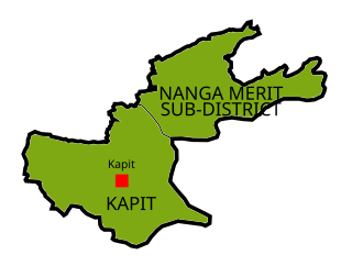
Kapit is a district, in Kapit Division, Sarawak, Malaysia.

Kanowit is a district, in Sibu Division, Sarawak, Malaysia.

Kabong is a district, in Betong Division, Sarawak, Malaysia.
Song is a district, in Kapit Division, Sarawak, Malaysia.

Bukit Mabong is a district, in Kapit Division, Sarawak, Malaysia.
