Julau | |
|---|---|
 Flag  Seal | |
| Country | |
| State | |
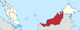
| Division | Sarikei Division |

Julau is a district, in Sarikei Division, Sarawak, Malaysia. [1] [2]
Julau | |
|---|---|
| Flag Seal | |
| Country | |
| State | |
| Division | Sarikei Division |
Julau is a district, in Sarikei Division, Sarawak, Malaysia. [1] [2]
Julau District Office is located in the town.
A primary school named "SK Nanga Entabai" is located here. [3]
Construction of a steel bridge across the Julau river started in November 2021. [4]
Nanga Maong public health clinic is located here. [5]
Sarawak is a state of Malaysia. The largest among the 13 states, with an area almost equal to that of Peninsular Malaysia, Sarawak is located in the region of East Malaysia in northwest Borneo, and is bordered by the Malaysian state of Sabah to the northeast, Kalimantan to the south, and Brunei in the north. The state capital, Kuching, is the largest city in Sarawak, the economic centre of the state, and the seat of the Sarawak state government. Other cities and towns in Sarawak include Miri, Sibu, and Bintulu. As of the 2020 Malaysia census, the population of Sarawak was 2.453 million. Sarawak has an equatorial climate with tropical rainforests and abundant animal and plant species. It has several prominent cave systems at Gunung Mulu National Park. Rajang River is the longest river in Malaysia; Bakun Dam, one of the largest dams in Southeast Asia, is located on one of its tributaries, the Balui River. Mount Murud is the highest point in the state. Sarawak is the only state of Malaysia with a Christian majority.

Sibu is a landlocked city located in the central region of Sarawak, Malaysia. It serves as the capital of Sibu District within Sibu Division and is situated on the island of Borneo. Covering an area of 129.5 square kilometres (50.0 sq mi), the city is positioned at the confluence of the Rajang and Igan Rivers, approximately 60 kilometres from the South China Sea and 191.5 kilometres (119 mi) north-east of the state capital, Kuching.

Limbang is a border town and the capital of Limbang District in the Limbang Division of northern Sarawak, East Malaysia, on the island of Borneo. This district area is 3,978.10 square kilometres, and population was 56,900. It is located on the banks of the Limbang River, between the two halves of Brunei.

Sarikei is a town, and the capital of Sarikei District in Sarikei Division, Sarawak, Malaysia. It is located on the Rajang River, near where the river empties into the South China Sea. The district population was 56,798.

The Rajang River is a river in Sarawak, northwestern Borneo, Malaysia. The river originates in the Iran Mountains, flows through Kapit, and then towards the South China Sea. At approximately 565 km long (351 mi), the river is the seventh-longest in Borneo and the longest in Malaysia.

Kapit is a town and the capital of Kapit District in Kapit Division, Sarawak, Malaysia on the south bank of the Rajang River. The district comprises 15,595.6 square kilometres and as of 2020, it has a population of 65,800.
Kanowit is a town and the capital of Kanowit District, Sibu Division, Sarawak, Malaysia, comprising 2,253.5 square kilometres. As of 2010, Kanowit's population is 28,985. It is built on the mouth of Kanowit River at the bank of Rajang River, approximately 174 kilometers from the coast of South China Sea. It takes 45 minutes to reach the town by land transport and an hour by boat from Sibu. The main ethnic groups are Iban, Chinese, Malay, and Melanau.

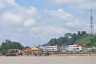
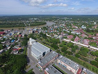
Julau is a town, and the capital of the Julau District in Sarikei Division, Sarawak, Malaysia. The district population is 15, 333. The population is dominated by Iban as well as Chinese especially the Fuzhou.

Kota Samarahan, formerly known as Muara Tuang, is a town and the administrative seat of the Samarahan District in Samarahan Division, Sarawak, Malaysia. It is also a satellite town for Kuching due to its proximity to the city part of Greater Kuching area. The Sarawak government position Kota Samarahan as the medical and education hub of the state. Saramahan is the heart of Sarawak Malays which is majority of 56%.

Lubok Antu District is a district in the Sri Aman Division of the state of Sarawak, Malaysia. It borders on Indonesia and a Malaysian border crossing checkpoint is located here. The checkpoint on the Indonesian side is called the Nanga Badau Border Crossing Checkpoint located in the village of Badau, West Kalimantan. The seat of Lubok Antu District is the town of Lubok Antu.

Dalat is the administrative town of the Dalat district in Mukah Division, Sarawak, Malaysia. It is situated by the Oya River.
Pakan is a small town in Pakan District, Sarikei Division, Sarawak, Malaysia. The district population estimates was 17,600.

Selangau, Sarawak, is a small town located by the Pan Borneo Highway. It is also located by Batang Mukah, a river which flows to the South China Sea. It is located approximately 74 km (46 mi) from Sibu city, 84 km (52 mi) from Mukah town and 134 km (83 mi) from Bintulu town. Selangau town is the administrative centre for the Selangau District.
The Dalat District is located in Mukah Division, Sarawak, Malaysia. It is situated by the Oya river. The district covers areas from Kg. Penat to Oya, and from Muara Sg. Kut to Ulu Baoh. The district has an area of 905.29 km2, while the Oya sub-district has an area of 147.47 km2.

Sibu District is an administrative district in Sibu Division, Sarawak, Malaysia covering a total area of 2229.8 km2. It can be divided into Sibu Town area (129.5 km2) and the rural areas (2,100.3 km2). The satellite township of Sibu Jaya is included in the rural areas. Sibu District is under the purview of Sibu District Office located at Sibu Islamic Complex, Sibu City. There are currently two local authorities namely Sibu Municipal Council (SMC) and Sibu Rural District Council (SRDC) that administers Sibu City and Sibu rural areas respectively.
Mukah (muːkəh), historically known as Muka is a coastal town which has served as the capital and the administrative center of the Mukah Division since 1 March 2002.
Meluan is a state constituency in Sarawak, Malaysia, that has been represented in the Sarawak State Legislative Assembly since 1969.
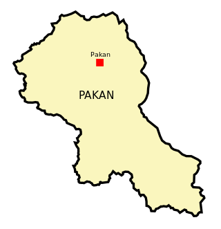
Pakan District is an administrative district in Sarikei Division, Sarawak, Malaysia, covering an area of 924.6 square kilometres (357.0 sq mi). The town of Pakan is the capital of the Pakan district, located 45 km from the town of Sarikei.

Datuk Larry Sng Wei Shien, is a Taiwanese-born Malaysian politician who has served as the Member of Parliament (MP) for Julau since May 2018. He served as Member of the Sarawak State Legislative Assembly (MLA) for Pelagus from September 2001 to April 2011. He was previously the State Chairman of the People's Justice Party (PKR) of Sarawak, a component party of the Pakatan Harapan (PH) coalition. On 28 February 2021, he left PKR to become an independent again and declared support for the ruling Perikatan Nasional (PN) coalition. He is currently the President of Parti Bangsa Malaysia (PBM) and has served in this role since January 2022. Following the 2022 general election, he is presently the sole PBM MP and his party is aligned to the Unity Government.

The Sarawak rabies outbreak is an ongoing rabies outbreak in the state of Sarawak in Malaysia. Until 6 December 2022, 49 confirmed rabies cases and 44 deaths have been reported.
Capital: Kuching | |
| History | |
| Topics | |
| Society |
|
| Administrative divisions | |
| | This Sarawak location article is a stub. You can help Wikipedia by expanding it. |