Bintulu District

Last updated

Bintulu District
District of Sarawak
Flag of Sarawak.svg
Flag
Sarawakbintulubtu.png
District Office location Bintulu
Local area government (s) Bintulu Development Authority (BDA)
Government
  Resident OfficerHaji Ismail Bin Haji Mohd. Hanis
  District OfficerTuah anak Suni
Area
  Total1,990.40 km2 (768.50 sq mi)
Population
 (2008, estimate)
  Total186,100
  Density93/km2 (240/sq mi)
Ethnicity
   Iban 38.3%
   Chinese 17.9%
   Melanau 11.4%
  Others32.4%
Map of Bintulu District Map of Bintulu District, Sarawak.svg
Map of Bintulu District

The Bintulu District is one of two districts of Bintulu Division in Sarawak, Malaysia. It has a total area of 7,220.40 square kilometres. Bintulu District has a sub-district, which is Sebauh. There are two towns in Bintulu District, namely Bintulu, which is the capital of both Bintulu District and Bintulu Division, and Sebauh.

Contents

Demography

The population of Bintulu District (year 2008 estimate) was 186,100. Most of the Bintulu district's population is concentrated at Bintulu proper.

Ethnics

Bintulu is traditionally a home to Iban, Chinese, Melanau, Malay, Orang Ulu and Kedayan people. Most Ibans are scattered throughout rural areas of Bintulu, namely in Tatau and Sebauh. Whilst, Melanau people (or Melanau Bintulu/Vaie people) are concentrated at the town areas in Bintulu and rural communal areas, namely at Bintulu town, Sebauh, Pandan and Labang. Many Malay people are not originally from Bintulu, however, intermarriage with locals especially Melanau people has made Malay as one of the major ethnics in Bintulu. Chinese people are more concentrated at town areas, such as at Bintulu, Sebauh and Tanjung Kidurong, while some resides at Kuala Kebulu and Jelalong. Orang Ulu people, such as Kenyah, Kayan, Tatau, Penan and Punan are more scattered throughout Bintulu district compared to Iban people. Most of them still live deep in the rural areas like Kakus and Jelalong. Kedayan people, although small in number, can be spotted at Nyalau areas (100 km from Bintulu) just at the border with Miri Division.

There is a large influx of foreign worker population due to the strength of the petroleum industry. It was estimated more than 20% of Bintulu population are foreign workers and expatriates.

Population of Bintulu by Ethnics [1] [2]
Administrative DistrictTotal
Population
MalayIbanBidayuhMelanauOther
Bumiputera
ChineseOther
Non-Bumiputera
Non-Citizen
Bintulu186,100
(84.5%)
17,500
(9.4%)
71,300
(38.3%)
2,500
(1.4%)
21,200
(11.4%)
8,700
(4.7%)
33,300
(17.9%)
900
(0.4%)
30,700
(16.5%)

Economy

The economy is largely based on the petroleum and natural gas industries. Bintulu has an estimated 85% of Sarawak's known natural gas reserves, or some 42.3 trillion cubic feet (1,200 km3). In addition to export as liquified natural gas, on-shore facilities produce fertiliser, and formaldehyde resins. Bintulu also has about half of Sarawak's crude oil reserves of 500 million barrels (79,000,000 m3), with production wells located some 40 kilometers offshore.

Bintulu has around 27% of Sarawak's tropical rainforest, and the timber industry remains a strong component of the Division's economy. Agriculture is relatively minor although growing steadily, with oil palm, rattan and pepper the main products. Deposits of coal have been discovered, but are yet unexploited.

Transportation

Although Bintulu is well connected to other parts of Sarawak with good networks of road, river transports still play the vital role in Bintulu. People of Bintulu District can opt for rural shuttle bus service to Tatau, Sebauh, Nyalau, even as far as Sungai Asap in Kapit Division. The only shuttle bus operating for both town and rural services is Jepak Holding.

As for people who wish to travel to upriver areas which are inaccessible by road such as Jelalong, Ng. Tau, Pandan, Labang, Kuala Serupai, Kuala Baggiau, Sungai Anap and Bukit Balai, they have to use available ferry and boat services. River transport charges remain high in Bintulu Division due to the long distance of the upriver areas.

There are some rural areas which are accessible by timber tracks and palm estate roads such as Labang, Tubau and Kakus. Availability of transports to these areas are limited through bookings at Bintulu town, using private vans or four-wheel drive vehicles.

Infrastructure

Pan-Borneo Highway is a trunk road linking Bintulu to the rest of Sarawak. Bintulu District is expected to expand rapidly due to Similajau being part of Sarawak Corridor of Renewal Energy regional development and ongoing gas pipeline project from Sabah to Tanjung Kidurong.

Education

Bintulu District has a moderate number of public schools. Most secondary schools in Bintulu Division are located at Bintulu district. As for primary schools, most of them are scattered throughout Bintulu. Some of them are located deep in the Bintulu district's interior to cater for rural students. There is one secondary school run privately which is SM Kai Dee, a Chinese education-based school.

Bintulu District is home to a public university branch which is Universiti Putra Malaysia (UPM) and various government education institutions such as GIATMARA, IKM and ADTEC. There is also a private education institution which is Kolej Sedamai.

Healthcare

Bintulu District has one government hospital which is Bintulu Hospital and one government policlinic at Bintulu town. There are also private-owned hospital such as Columbia-Asia Hospital at Tanjung Kidurong and Rejang Hospital at Bintulu town. As for Tatau and Sebauh sub-district, both has their own health clinic. Smaller government health clinics do exist at Labang and Tubau.

Security

Bintulu District has a police district office. There are also police stations and police bits located at strategic locations, as well as rural areas. Like other district in the division, Bintulu so far has no district military bases. Only small military camps do exist just to make presence.

Government services

Many government offices have set up their branches in Bintulu district (some at Sebauh sub-district and other smaller communal areas) such as Royal Customs, Fire and Rescue Department, Education Department, etc.

See also

Related Research Articles

Tanjung Kidurong, known as simply Kidurong, is a port town in Sarawak, Malaysia. Approximately 15 minutes from the centre of Bintulu, Kidurong functions as the main industrial core of the Bintulu area. The MLNG Complex, which is the largest single gas manufacturing complex in the world, is in Kidurong. Shell and Murphy are among the other oil and gas multinationals that operate in the Kidurong Industrial Estate. The oil and gas industry in the Kidurong Industrial Area since the 1980s has brought along an expatriate community, who also live in Kidurong, notably around Tamam Matahari and MLNG Housing. This has also led to a higher price of homes in Kidurong, compared to the other suburbs in Bintulu. There is also a fairly large squatter community around the Sg. Plan area, which is roughly 3 km (1.9 mi) from the middle-class and prosperous neighbourhoods in the area. Most of the squatters came from rural areas in search of a better life in Bintulu.

Punan Bah Ethnic group from Borneo

Punan Bah or Punan is an ethnic group found in Sarawak, Malaysia and in Kalimantan, Indonesia. The Punan Bah people are distinct and unrelated to the semi-nomadic Penan people. Their name stems from two rivers along the banks of which they have been living since time immemorial. They do have other names: Mikuang Bungulan or Mikuang and Aveang Buan. But those terms are only used ritually these days.

Bintulu Division Division of Sarawak

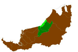
Bintulu Division is one of the twelve administrative divisions of Sarawak, Malaysia. It has a total area of 12,166.2 square kilometres, and is the third largest division after Kapit Division and Miri Division. Bintulu Division consists of two districts which is Bintulu and Tatau, together with a sub-district under Bintulu, which is Sebauh. Three major towns in Bintulu are Bintulu, Tatau and Sebauh.

Tatau Place in Sarawak, Malaysia

Tatau is a town, and the capital of the Tatau District in Bintulu Division, Sarawak, Malaysia. The district's reported total population for Tatau was 30,383. Tatau became a district in 1987. Before that it was a Sub District under Bintulu District. The main spoken languages are Iban, Kenyah, Beketan and Punan.

Miri Division Place

Miri Division is one of the twelve administrative divisions of Sarawak, Malaysia. It has a total area of 26,777.1 square kilometres, and is the second largest division after Kapit Division. The seat of this division is the city of Miri.

Mukah Division Place

Mukah Division is one of the twelve administrative divisions in Sarawak, Malaysia. It was established on 1 March 2002 and it has a total area of 6,997.61 square kilometres.

Kuching Division Place

Kuching Division is one of the twelve administrative divisions in Sarawak, Malaysia. Formerly part of what was called the "First Division", it is the center and the starting point of modern Sarawak. Kuching Division has a total area of 4,559.5 square kilometres.

Dalat, Sarawak Place

Dalat is the administrative town of the Dalat district in Mukah Division, Sarawak, Malaysia. It is situated by the Oya river.

Melanau people

Melanau or A-Likou is an ethnic group indigenous to Sarawak, Malaysia. They are among the earliest settlers of Sarawak. They speak in the Melanau language, which is a part of the North Bornean branch of Malayo-Polynesian languages.

Limbang Division Place

Limbang Division is one of the twelve administrative divisions of Sarawak, Malaysia. It has a total area of 7,788.50 square kilometres, and is the fourth largest division after Kapit Division, Miri Division and Bintulu Division. Limbang Division consists of two districts which are Limbang District and Lawas District, which in turn are divided as sub-districts in Limbang and two sub-districts in Lawas. Long Semadoh and Ba’kelalan are rural settlements in the southern part of Lawas district. Two major towns in Limbang are Limbang and Lawas. There are also few smaller towns such as Sundar, Trusan, Merapok and Tedungan.

Bintulu Place in Sarawak, Malaysia

Bintulu is a coastal town on the island of Borneo in the central region of Sarawak, Malaysia. Bintulu is located 610 kilometres (380 mi) northeast of Kuching, 216 kilometres (134 mi) northeast of Sibu, and 200 kilometres (120 mi) southwest of Miri. With a population of 114,058 as of 2010, Bintulu is the capital of the Bintulu District of the Bintulu Division of Sarawak, Malaysia.

Tatau District Districts of Sarawak

Tatau District is one of the two districts of Bintulu Division in Sarawak, Malaysia. It has a total area of 4,945.80 square kilometres. The largest town in the district is Tatau.

Sebauh District District of Bintulu

Sebauh is a district of Bintulu Division, Sarawak, Malaysia. It shares a boundary with Miri, Baram, Kapit Division, Belaga and Tatau. It has a total area of roughly 5,262.90 square kilometres. Sebauh town is a main administrative and economy centre of Sebauh district.

Limbang District Place in Malaysia

The Limbang District is one of the two districts of Limbang Division, Malaysia. It has a total area of 3,976.00 square kilometres. The major town is Limbang. It has one sub-district, which is Nanga Medamit Sub-District. It borders Brunei Darussalam to the west and east, Lawas District to the southeast and Miri District at the south and southwest. Due to being squeezed in between Brunei at its north and coastal areas, Limbang is accessible by road only by going through immigration posts.

Balingian Place in Sarawak, Malaysia

Balingian is a town in Sarawak, Malaysia. It lies approximately 286.1 kilometres (178 mi) east-north-east of the state capital Kuching.

Selangau Place

Selangau, Sarawak, is a small town located by the Pan Borneo Highway. It is also located by Batang Mukah, a river which flows to the South China Sea. It is located approximately 74 km (46 mi) from Sibu town, 84 km (52 mi) from Mukah town and 134 km (83 mi) from Bintulu town. Selangau town is the administrative centre for the Selangau District.

Sarawak's population is very diverse, comprising many races and ethnic groups. Sarawak has more than 40 sub-ethnic groups, each with its own distinct language, culture and lifestyle. This makes Sarawak demography very distinct and unique compared to its Peninsular counterpart.

Data Kakus Place in Sarawak, Malaysia

Data Kakus is a remote Kenyah Badeng village settlement in the hilly interior of the Ulu Kakus Tatau division of Sarawak, Malaysia elevates to 650 metres, not far from Tubau and Belaga district. To be exact, Data Kakus is located at the upstream of Sungai Burok and Sungai Nyabet. The highest peak in Ulu Kakus is called Gunung Lumut about 828m located on the peak of Lumut Range not too far from Sungai Bekuyat and Sungai Kakus.

Kemena is a state constituency in Sarawak, Malaysia, that has been represented in the Sarawak State Legislative Assembly since 1969.

Bintulu is a federal constituency in Sarawak, Malaysia, that has been represented in the Dewan Rakyat since 1971.

References

  1. Sarawak Ethnic Statistic from Sarawak Journal.
  2. Sarawak Ethnic Statistic from Sarawak Journal.

Coordinates: 3°11′56″N113°06′07″E / 3.199°N 113.102°E / 3.199; 113.102