Seberang Perai

Last updated

Seberang Perai
Province Wellesley
City of Seberang Perai
Bandaraya Seberang Perai
Other transcription(s)
   Mandarin 威省(Simplified)
威省(Traditional)
Wēishěng(Pinyin)
   Tamil செபராங் பிறை
Ceparāṅ Piṟai(Transliteration)
   Thai เซอเบอรังเปอไร
Soeboerangpoerai(RTGS)
Flag of Seberang Perai Municipal Council.png
Seberang Perai City Council (MBSP - Majlis Bandaraya Seberang Perai) Logo.png
Seberang Perai
Location map of Seberang Perai.svg
Red pog.svg
Seberang Perai
Malaysia location map.svg
Red pog.svg
Seberang Perai
Asia laea location map.svg
Red pog.svg
Seberang Perai
Coordinates: 5°24′29.95″N100°22′10.37″E / 5.4083194°N 100.3695472°E / 5.4083194; 100.3695472
Country Flag of Malaysia.svg  Malaysia
State Flag of Penang (Malaysia).svg  Penang
Districts North, Central and South
Mukims [1] Butterworth and 56 subdistricts
Founded [2] 1800
Establishment of local governments [2] 1913
Municipality [3] 15 December 1976
Incorporated (city) [3] 16 September 2019
Government
  Type City council
  Body Seberang Perai City Council
  Mayor [4] Azhar Arshad
  City Secretary [4] Hj Baderul Amin Abdul Hamid
Area
  City748 km2 (289 sq mi)
Population
 (2020) [5]
  City946,092
  Rank 3rd in Malaysia
1st in Penang
  Density1,264.8/km2 (3,276/sq mi)
Demographics
[5]
  Ethnic groups
Time zone UTC+8 (MST)
  Summer (DST)Not observed
Postal code
12xxx–14xxx
Area code(s) +604-3, +604-5
Website www.mbsp.gov.my

Seberang Perai is a city in the Malaysian state of Penang. Located on the Malay Peninsula and separated from Penang Island by the Penang Strait, it shares borders with Kedah to the north and east, and Perak to the south. The city spans an area of 748 km2 (289 sq mi) and had a population of 946,092 as of 2020, making it the third largest city in Malaysia. [5] [6]

Contents

Originally a part of Kedah, the territory containing the city was ceded to the British East India Company in 1800. It was named Province Wellesley and has been administered as part of Penang ever since. [2] [7] The territory became a centre for cash crop agriculture, while the development of new towns such as Butterworth and Bukit Mertajam followed with the advent of roads and railways towards the end of the 19th century. [7] [8]

After Malaya's independence, Seberang Perai benefitted from the development spillover from George Town. [9] [10] The Port of Penang, the third busiest seaport in the country, was relocated to the municipality in 1974, bolstering its burgeoning industrial-based economy that has attracted numerous multinational companies. [11] [12] [13] Two road bridges were constructed to physically connect Seberang Perai with George Town, complementing an existing ferry service between the two cities. [14] Penang Sentral, a new transit-oriented development, has strengthened Seberang Perai's role as the logistics hub of northwestern Malaysia. [15] [16] Following decades of rapid urbanisation and infrastructural developments, Seberang Perai was conferred city status in 2019. [10] [17]

Etymology

Seberang Perai was originally named Province Wellesley after Richard Wellesley, who was the Governor-General of India when the territory was acquired by the British East India Company (EIC) in 1800. [18] The term 'Seberang Perai' is believed to have emerged from a local expression used to refer to the northern banks of the Perai River. [19] After the acquisition of Province Wellesley, the river became the boundary between British-held territory to the south and Kedah to the north. The Thai word plāi (Thai : ปลาย), meaning "the end", referred to the southern limits of Kedah, which were formed by the river. [20]

The Hokkiens referred to the northern banks of the river as koay kang, which means "to cross the river." At the time, passengers from George Town would land at Perai and cross the river to get to Butterworth and the hinterland beyond. The term koay kang coincides with the Malay name Seberang Perai. [19]

History

Historical affiliations

Flag of the British East India Company (1801).svg British East India Company 1800–1858
Flag of the United Kingdom.svg British Raj 1858–1867
Flag of the British Straits Settlements (1925-1946).svg  Straits Settlements 1826–1941; 1945–1946
Merchant flag of Japan (1870).svg Empire of Japan 1941–1945
Flag of the Federated Malay States (1895-1946).svg  Malayan Union 1946–1948
Flag of Malaya.svg  Federation of Malaya 1948–1963
Flag of Malaysia.svg  Malaysia 1963–present

Early history

Seberang Perai bears evidence of human habitation during the Neolithic era. The site of Guar Kepah, located on the southern banks of the Muda River, is home to human remains found in shell middens that indicate the settlement of the area in that period. [21] [22] Guar Kepah remains the only known example of coastal adaptation among Neolithic humans in Malaysia. [21]

Seberang Perai was once a part of the Bujang Valley civilisation. [23] The Mahanavika Buddhagupta plaque and the Cherok Tok Kun megalith, found at Bukit Mertajam, both indicate significant Hindu influence at the area between the 5th and 6th centuries. [23] [24]

British rule

British acquisition and expansion of Penang (in yellow) occurred between 1786 and 1874, when the final alterations to Penang's boundaries was enacted. Penang.gif
British acquisition and expansion of Penang (in yellow) occurred between 1786 and 1874, when the final alterations to Penang's boundaries was enacted.

In 1786, Francis Light acquired Penang Island from Kedah in exchange of British military protection. [29] However, when Sultan Abdullah Mukarram Shah of Kedah attempted to retake the island by force in response to the EIC's reneging on military protection, British forces launched a preemptive assault on Perai. The Kedahan forces were routed and the Sultan was forced to sue for peace. [7] [30]

In 1800, the EIC annexed a strip of the mainland from Kedah for a sum of 4,000 Spanish dollars. [2] [7] [31] This acquisition, negotiated by George Caunter on behalf of Lieutenant-Governor George Leith, gave the EIC permanent sovereignty over both Penang Island and the newly-acquired territory, which was named Province Wellesley after Governor-General of India Richard Wellesley. [32] The Perai River became the international border between British and Kedah territories. [20]

The EIC had sought to turn the island into an agricultural outpost. [8] The annexation of Province Wellesley allowed for the expansion of the cash crop industry from the island to the mainland. This led to the harvesting of spices and sugar, which attracted migrants from China, India, Myanmar and the Middle East, as well as Malay refugees from Kedah fleeing the Siamese conquest of their homeland. [7] [8] [33] In 1831, the EIC expanded Province Wellesley northwards, moving the international border between British and Siamese territories from the Perai River to the Muda River. [34] The territory's boundaries were further expanded in 1868 and in the Pangkor Treaty of 1874, effectively enlarging the British-held territory from the Muda River in the north to the Kerian River in the south. [35] [36]

The development of roads and railways in the early 20th century promoted the growth of Province Wellesley's rubber industry. [8] Malaya's new rail lines, which ran from the Siamese border to the north to Singapore to the south, cut through Province Wellesley, allowing the Port of Penang to become a major tin exporter. This led to the emergence of new towns, such as Butterworth and Bukit Mertajam, as logistics hubs. The Municipal Ordinance of 1913 resulted in the creation of three local governments within Province Wellesley the Butterworth and Bukit Mertajam town boards, and the Province Wellesley Rural Board. [2] [8] The creation of local governments further accelerated infrastructural developments within the territory. [8]

World War II

A British pillbox along the northern frontier of Province Wellesley during the Malayan Campaign. Jambatan Merdeka Pillbox 01.jpg
A British pillbox along the northern frontier of Province Wellesley during the Malayan Campaign.

RAF Butterworth was opened just a few months prior to the outbreak of hostilities between Britain and Japan in December 1941. [37] As Japanese troops landed in Kota Bharu and Songkhla, Allied squadrons defending northern Malaya were decimated and had to retreat to RAF Butterworth by 8 December. [38] The air base was subsequently attacked by Japanese bombers on the following day. [39] The Royal Air Force eventually abandoned it on 15 December. Penang fell to the Japanese four days later.

During the Japanese occupation, Province Wellesley, like George Town, underwent significant social upheaval. Civilians suffered harsh treatment from the Japanese, who attempted to enforce order, while living conditions worsened along with the economic situation. [8] Rice farmers in Province Wellesley were encouraged to increase their yields, but the shortfall in rice supply proved too great to be substituted. [39] Despite the establishment of "pioneer farms" in the territory by Japanese administrators in 1944, food shortages persisted until the end of the war when British forces liberated Penang. Following the war's end, British authorities swiftly undertook to restore order in Province Wellesley, which was plagued by elements of the Chinese underworld and communist infiltrations. [8] [39]

Post-independence

In 1953, the British reorganised the local governments within the territory. [2] [8] Five local governments one each for the municipalities of Butterworth and Bukit Mertajam, and three rural district councils were instituted. [2] [40] [41] After Malaya's independence in 1957, the ruling Alliance coalition moved to amalgamate the local governments within Seberang Perai. [42] In 1961, the Butterworth and Bukit Mertajam municipalities were consolidated with the North and Central Seberang Perai rural district councils, respectively. [2] [43] The three remaining local governments were subsequently merged into a single municipality in 1974. [3] Two years later, Seberang Perai was conferred municipal status and the local government was renamed the Seberang Perai Municipal Council. [3]

In the early 1960s, the Penang state government began industrialising Seberang Perai through the establishment of the first industrial estates at Mak Mandin and Perai. [44] In 1974, the Port of Penang was relocated from George Town to the municipality and in 1980, the adjacent Perai Free Industrial Zone in 1980 was created to leverage on the available maritime and rail infrastructure. [12] [45] These were accompanied by a significant increase in the municipality's population, which was largely due to the spillover of development from George Town. [9] [10]

Decades of economic growth and the availability of industrial land have led to substantial investments in infrastructure, including the completion of the Penang Bridge and the Second Penang Bridge that connect the municipality with George Town. [10] [14] [46] The industrial sector has also spurred the development of newer townships within the municipality such as Seberang Jaya and Batu Kawan. [47] Seberang Perai was granted city status in 2019. [17]

Geography

Location map of Seberang Perai (city centre shown).svg

Seberang Perai spans the entire mainland portion of Penang. With a total land mass of 747.8 km2 (288.7 sq mi), Seberang Perai is slightly larger than Singapore. α [6] The terrain of the city is mostly flat and alluvial, except for the hilly region along its eastern border with Kedah. [48] Standing at a height of 1,787 ft (545 m), Mertajam Hill is the tallest point within Seberang Perai. The city's coast is divided into a northern sandy shoreline and a muddy, mangrove-covered southern coastline. The southern coast is geographically sheltered by Penang Island, while the northern shoreline is more exposed to the forces of the Malacca Strait. [48]

Seberang Perai's jurisdiction also includes two offshore islets Aman and Gedung islands. [49] These islets feature mudflats that connect with the mainland due to sedimentation that occurred during the construction of the Penang Bridge. [48]

The city is demarcated by the Muda River to the north, which serves as the border between Seberang Perai and Kedah. [50] To the south, the tripoint between Seberang Perai, Kedah and Perak lies within the Kerian River. [51] Several riverine systems flow through the city, including Perai, Juru, Jejawi and Tengah rivers. [48] River pollution caused by industrial waste has been a persistent issue for decades, with the Juru, Jawi and Perai rivers classified as having average water quality (Class III) by Malaysia's Department of Environment since 2016. [52]

Climate data for Butterworth (2016–2022)
MonthJanFebMarAprMayJunJulAugSepOctNovDecYear
Mean daily maximum °C (°F)32.2
(90.0)
33.0
(91.4)
32.8
(91.0)
32.6
(90.7)
32.3
(90.1)
32.1
(89.8)
32.1
(89.8)
31.9
(89.4)
31.3
(88.3)
31.1
(88.0)
30.9
(87.6)
31.5
(88.7)
32.0
(89.6)
Mean daily minimum °C (°F)24.0
(75.2)
23.7
(74.7)
24.7
(76.5)
25.1
(77.2)
25.3
(77.5)
25.0
(77.0)
24.9
(76.8)
24.6
(76.3)
24.4
(75.9)
24.6
(76.3)
24.6
(76.3)
24.3
(75.7)
24.6
(76.3)
Average precipitation mm (inches)96.3
(3.79)
83.6
(3.29)
100.7
(3.96)
183.7
(7.23)
261.0
(10.28)
148.9
(5.86)
185.9
(7.32)
126.3
(4.97)
293.4
(11.55)
291.9
(11.49)
266.3
(10.48)
112.9
(4.44)
2,150.9
(84.66)
Average precipitation days7.66.07.113.414.910.011.112.616.017.313.910.3140.2
Source: Meteomanz [53]

Governance and politics

Local government

Flag of Seberang Perai Municipal Council.png
MBSP Bandar Perda (221003) (cropped).jpg
Above: Flag of the Seberang Perai City Council
Below: Menara Bandaraya, the headquarters of the city government, was completed in 2006, replacing the previous administrative offices at Butterworth. [54] [55] [56]
The former Seberang Perai City Council headquarters at Butterworth was in use until 2006. Old Seberang Perai Municipal Council headquarters at Butterworth.jpg
The former Seberang Perai City Council headquarters at Butterworth was in use until 2006.

Throughout the 19th century, Province Wellesley was administered from George Town without any local governance structure in place. [8] This changed in 1913 when the Municipal Ordinance came into effect, mandating the establishment of local governments in Province Wellesley. [2] [8] [57] Three local governments were created, namely the town boards for Butterworth and Bukit Mertajam, and the Province Wellesley Rural Board which administered the rest of the territory. [2]

The Seberang Perai City Council (MBSP) was formed following several reorganisations throughout the 20th century. In 1953, the Province Wellesley Rural Board was split into three rural district councils for the Northern, Central and Southern districts. [2] [40] After Malaya's independence, the local governments were gradually amalgamated by the then Alliance-controlled state government. The Butterworth and Bukit Mertajam municipal governments were merged with the North and Central Seberang Perai rural district councils, respectively, in 1961. [2] [43] The three remaining district councils were consolidated into a single municipality in 1974. [3] As a municipality, Seberang Perai was conferred municipal status in 1976 and city status in 2019. [3] [17]

One of the two city governments in Penang, MBSP is led by a mayor, assisted by a secretary and 24 councillors who perform oversight responsibilities over 18 departments. [58] The Penang state government appoints the mayor and councillors, with the councillors serving under an extendable one-year term. [59] Local government elections, which had been in place from 1961, were suspended following the Indonesia–Malaysia confrontation and have not been reinstated since. [60] [61] The mayor of Seberang Perai since 2022 is Azhar Arshad. [62]

MBSP's current urban planning strategy is outlined in the Seberang Perai Local Plan 2030, first published in 2021. [49] [63] In 2023, MBSP projected its estimated revenue at RM314.6 million and an estimated expenditure of RM357.13 million, which included allocations for infrastructure, economic growth, heritage conservation and community engagement. [64] γ

The city council's headquarters is Menara Bandaraya, located near Bukit Mertajam. [54] Administrative offices were relocated to the building in 2006 from the previous headquarters at Butterworth. [54] [56] [55] However, upon completion, Menara Bandaraya was mired in controversy. MBSP's reserves shrank by RM230 million between 2000 and 2007, allegedly due in part to the financing of the new headquarters. [65] [66] Cost overruns forced the developer, with links to the then-ruling Barisan Nasional coalition, to scale down construction to the present-day building. [56] [66] In total, the city government spent nearly RM85 million on the building. [66]

State and national representation

Distribution of ethnic
.mw-parser-output .legend{page-break-inside:avoid;break-inside:avoid-column}.mw-parser-output .legend-color{display:inline-block;min-width:1.25em;height:1.25em;line-height:1.25;margin:1px 0;text-align:center;border:1px solid black;background-color:transparent;color:black}.mw-parser-output .legend-text{}
Chinese and
Malays in Seberang Perai, derived from the 2020 Malaysian census. Map of Seberang Perai by ethnic proportions 2020.svg
Distribution of ethnic    Chinese and    Malays in Seberang Perai, derived from the 2020 Malaysian census.

Seberang Perai is represented by seven Members of Parliament and 21 state constituencies. [67] Prior to 2023, state elections had been conducted simultaneously with nationwide general elections every five years. As of 2023, ethnic Malays formed the majority in 11 of the 21 state constituencies, especially in the city's north. [67] On the other hand, non-Malays were largely clustered in urban constituencies such as at Butterworth, Perai, Bukit Mertajam and Batu Kawan, as well as much of the coastal areas in the south. In the 2023 state election, the Pakatan Harapan-Barisan Nasional alliance retained 12 of Seberang Perai's constituencies, whereas the far-right Perikatan Nasional opposition bloc won nine Malay-majority seats across swathes of the north and southeast. [67]

Parliamentary constituencies [67]

State constituencies [67]

Judiciary

Seberang Perai has a judicial system that consists of the magistrate and sessions courts. Each of the city's three districts is served by these courts. The north district cases are under the jurisdiction of the Butterworth Magistrates Court, while the central district cases are presided over by the Bukit Mertajam Magistrates Court. [68] The south district cases are handled by the Jawi Magistrates Court. The Royal Malaysia Police is responsible for law enforcement within Seberang Perai, establishing a total of 20 police stations throughout the city as of 2022. [69] [70] [71]

Demographics

Historical population
YearPop.±%
1921130,341    
1931141,388+8.5%
1947183,616+29.9%
1957233,234+27.0%
1970343,010+47.1%
1980432,982+26.2%
1991545,688+26.0%
2000655,711+20.2%
2010818,197+24.8%
2020946,092+15.6%
Source: [5] [72] [73] [74] [75] [76] [77] [78] [79]
Ethnicities of Seberang Perai in 2020 [5]
Ethnicities / NationalityPercentage
Malays
49.0%
Other Bumiputeras
0.3%
Chinese
32.9%
Indians
9.6%
Others
0.4%
Non-Malaysians
7.7%

According to the 2020 Malaysian census, Seberang Perai had a population of 946,092 within its jurisdiction of 748 km2 (289 sq mi), giving it a population density of 1,264.8/km2 (3,276/sq mi). [5] This also makes Seberang Perai the third largest city by population in Malaysia after Kuala Lumpur and Kajang. Seberang Perai is also the most populous settlement within the George Town Conurbation, containing over 54.3% of Penang's population. The city centre of Butterworth recorded a population of 80,378, or approximately 8.5% of the total population of Seberang Perai. [1]

In the decades since Malaya's independence, Seberang Perai's population grew rapidly due to the spillover of development from George Town. [9] Between 1975 and 1990, suburban sprawl became more pronounced within the northern and central districts of the city. [80] By 1991, Seberang Perai's population outstripped that of Penang Island for the first time in the state's history. β

Ethnicities

As of 2020, Malays accounted for 49% of Seberang Perai's population and was the majority ethnic group in the northern part of the city. [5] Ethnic Chinese constituted a significant proportion of the city's population at nearly 33%, followed by the Indians at almost 10%. During the British colonial era, agriculture had promoted significant immigration from China and India, resulting in sizable non-Malay populations within the central and southern districts of the city. [7] [8] [5] In particular, Chinese comprised the majority at areas like Butterworth, Bukit Mertajam and Nibong Tebal. [1]

Economy

Formerly regarded as a "poor cousin" to George Town, Seberang Perai has undergone significant transformation in the decades following Malaya's independence. [10] [81] [82] The Penang state government has been actively promoting a policy of balanced development between the two cities, and Seberang Perai has been positioned as the "future of Penang". [83] [84] In 2021, 'Penang Bay', an initiative aimed at promoting sustainable development, urban regeneration and creative economy between downtown George Town and Butterworth, was officially announced. [85]

With significant industrialisation since the 1970s, the city has been designated a "growth centre" within the George Town Conurbation. [8] [10] Nine of Penang's industrial clusters are located in the city, which has emerged as a significant recipient of foreign direct investment (FDI) and the seventh largest exporter in Malaysia. [86] [87] The development of newer townships has also driven economic diversification, with a growing services sector concentrated around retail and tourism. [88] [89] [90]

Manufacturing

The first industrial estates in Penang were established in the 1960s at Mak Mandin and Perai during the tenure of the state's first Chief Minister Wong Pow Nee. [91] However, these early efforts at industrialisation were limited to import substitution. [92] After the revocation of George Town's free port status and the fall of the Alliance-led state government in 1969, newly-elected Chief Minister Lim Chong Eu sought to restructure Penang's economy. [92] [93] The Nathan Report of 1970, produced by Robert R. Nathan Associates, proposed an export-led growth strategy and the strengthening of linkages with the global economy. [92] In 1980, the Perai Free Industrial Zone was created with the aim of becoming a significant manufacturing hub for bulk items, taking advantage of its proximity to the Port of Penang and the railway line that connects it to the rest of western Peninsular Malaysia. [92] [94]

Seberang Perai is now home to nine of Penang's industrial clusters namely at Mak Mandin, Perai, Seberang Jaya, Bukit Tengah, Bukit Minyak, Simpang Ampat and Batu Kawan. [86] [95] The availability of industrial land has attracted several local and multinational companies (MNCs), such as Mattel, Flex, Sanmina, JinkoSolar, Honeywell and Lam Research. [96] [97] [98] In 2022, Seberang Perai received investments worth nearly RM10.9 billion, which accounted for 79% of Penang's total inbound investments that year. [99] Within the same year, RM65.7 billion worth of exports passed through the Port of Penang, making Seberang Perai the seventh largest exporter among Malaysian cities. [87]

Services

Opened in 2016, Design Village at Batu Kawan houses 150 stores within a 400,000 sq ft (37,000 m) net lettable area. Design Village, Batu Kawan, Penang.jpg
Opened in 2016, Design Village at Batu Kawan houses 150 stores within a 400,000 sq ft (37,000 m) net lettable area.

The development of newer townships, namely Seberang Jaya and Batu Kawan, has given rise to a thriving retail sector, attracting major players such as Sunway Group and IKEA, respectively. [88] [101] In 2016, Design Village, Penang's first premium outlet mall, was launched, further enhancing Batu Kawan as a retail destination. [88] [100]

The Penang state government has undertaken initiatives to promote agritourism and ecotourism in Seberang Perai. [102] The Penang Tourism Master Plan, formulated in 2021, identified the city's agricultural sector, as well as natural features like mangroves, mudflats and waterways, as having untapped tourism potential. [103]

Seberang Perai has historically been the logistical hub of Penang, serving as a termini for rail and ferry services. The relocation of the Port of Penang to the city in 1974 facilitated the development of new container services. [45] [104] In 2022, the seaport handled close to 1.32 million TEUs of cargo, the third highest in Malaysia. [99] [105] The logistical role of Seberang Perai is further complemented by Penang Sentral, a transit-oriented development (TOD) at Butterworth that integrates land logistical and commercial components. [16]

Agriculture

Known as the "rice bowl" of Penang, Seberang Perai has a long history of agriculture. [8] [106] During British rule, spice, sugar and rubber were some of the major produces in the territory. Post-independence, the focus has shifted to rice, palm oil and coconut cultivation. [10] As of 2017, agriculture made up nearly 44% of Seberang Perai's land use. [49] The city had approximately 12,472 acres (5,047 ha) of paddy fields as of 2008, mainly located in the north. [10] [107] Despite limited land availability, Penang has consistently recorded the highest average rice yield in Malaysia since 2018, with a total yield of RM190.8 million in 2022. [108]

Culture

A container art installation at Butterworth, created in 2020. Container art at Butterworth, Seberang Perai 2024.jpg
A container art installation at Butterworth, created in 2020.

Seberang Perai's ethnic diversity has given rise to a variety of cultural celebrations throughout the year. Chinese New Year is celebrated at Chinese-majority areas such as Butterworth, where public events and decorated streets are a common sight during the annual festivities. [110] The Minor Basilica of St. Anne at Bukit Mertajam plays host to the annual Novena feast which draws thousands of pilgrims from abroad. [111] The 'Street of Harmony' at Seberang Jaya has nine places of worship, each representing a different faith, and is a tribute to religious diversity within the township. [112]

As part of urban renewal efforts, several locations at Butterworth have been adorned with street art. [113] [114] Additionally, container art pieces showcasing the identities of Penang's local communities have also been installed at Butterworth and Batu Kawan. [109] In recent years, Seberang Perai has emerged as a venue for newly-introduced events that celebrate the city's culture and nascent arts scene, such as the Butterworth Fringe Festival and the Penang International Paddy Festival. [115] [116]

Sports

The 40,000-seater Penang State Stadium at Batu Kawan is the main stadium of Penang. [117] Constructed in 2000 for the Sukma Games held that year, the multi-purpose stadium has a FIFA-certified football field, and is also used for hosting motorsports events and concerts. [117] [118] In addition to the stadium, newer sports facilities have been planned at areas like Nibong Tebal and Seberang Jaya. [119] [120]

Education

An entrance of Universiti Sains Malaysia's engineering campus at Nibong Tebal Tamanilmugate.jpg
An entrance of Universiti Sains Malaysia's engineering campus at Nibong Tebal

In the late 19th century, Islamic education, taught in huts called pondoks in Malay, was common in the rural areas of Province Wellesley. [121] These pondoks served as the precursors to the madrasa system and modern religious schools that are still prevalent across the city.

As of 2022, Seberang Perai is home to a total of 159 primary schools and 79 secondary schools, in addition to one international school located in the city's south. [69] [70] [71] In 2001, Universiti Sains Malaysia relocated its engineering campus to Nibong Tebal, and it is now one of the two public universities in the city, the other being a Universiti Teknologi MARA campus at Permatang Pauh. [122] Several private institutions have also been established throughout the city, including at Batu Kawan where local colleges have formed partnerships with foreign universities such as University of Wollongong and University of Plymouth. [122] [123] [124] Following the success of the Penang Digital Library in George Town, the Penang state government has initiated the construction of similar digital libraries at Butterworth and Bukit Mertajam. [125] [126]

Healthcare

Sunway Medical Centre, a private hospital at Seberang Jaya, was opened in 2022. Sunway Medical Centre Penang (220921).jpg
Sunway Medical Centre, a private hospital at Seberang Jaya, was opened in 2022.

Healthcare in Penang is provided by a two-tier system consisting of public and private hospitals. The Malaysian Ministry of Health administers four public hospitals in Seberang Perai namely at Kepala Batas, Seberang Jaya, Bukit Mertajam and Sungai Bakap. [128] [129] In addition, six private hospitals are scattered throughout the city. [128]

In recent years, private hospitals such as Bagan Specialist Centre, Sunway Medical Centre and KPJ Penang Specialist Hospital have contributed significantly in making Penang the top destination for medical tourism in Malaysia. [130] [131] The Seberang Perai City Council has also installed three automated external defibrillators (AEDs) throughout the city as of 2023 as part of a state-wide initiative to enhance survival rates of cardiac arrest cases. [132] [133]

Transportation

Land

Penang Sentral was designed to integrate bus, rail and ferry services, located in close proximity to both the Sultan Abdul Halim Ferry Terminal and the Butterworth railway station. Penang Sentral, Butterworth 20231224 075704.jpg
Penang Sentral was designed to integrate bus, rail and ferry services, located in close proximity to both the Sultan Abdul Halim Ferry Terminal and the Butterworth railway station.

Seberang Perai is connected to George Town by two road bridges. The 13.5 km (8.4 mi) Penang Bridge connects the suburb of Perai with Gelugor in the island city. [14] Opened in 2014, the Second Penang Bridge spans 24 km (15 mi) between Batu Kawan and Batu Maung on the island.

The North-South Expressway, a 966 km-long (600 mi) expressway along western Peninsular Malaysia, passes through the length of the city along with the Keretapi Tanah Melayu (KTM) West Coast Line. [134] [135] The Butterworth railway station serves as the principal terminal of northwestern Malaysia. [135] Apart from the regular KTM services, Butterworth is one of the main stops of the Eastern and Oriental Express service between Bangkok and Singapore. [136] Major toll routes in Seberang Perai include the Butterworth Outer Ring Road (BORR) and the Butterworth-Kulim Expressway. [137]

Opened in 2018, Penang Sentral is a transit-oriented development (TOD) located adjacent to the Butterworth railway station and the Sultan Abdul Halim Ferry Terminal. [15] [16] [138] It serves as an integrated hub for bus, rail and ferry services, and also includes office and retail components. The commercial components of Penang Sentral were under construction as of 2020. [138]

Rapid Penang is the primary public transport operator in Seberang Perai, with a total of 14 public bus routes within the city, along with two cross-strait routes connecting the city and George Town, as well as five interstate routes that run to southern Kedah and northern Perak. [139] In recent years, the Penang state government has proposed the introduction of urban rail across the state as part of the Penang Transport Master Plan. [140] The plan includes the cross-strait Mutiara LRT Line linking the city with George Town, and a monorail line between Butterworth and Bukit Mertajam. [141] [142]

Sea

North Butterworth Container Port (NBCT), part of the Port of Penang, has been gazetted as a Free Commercial Zone (FCZ) since 2021. Butterworth and Penang Scenery (31781843055).jpg
North Butterworth Container Port (NBCT), part of the Port of Penang, has been gazetted as a Free Commercial Zone (FCZ) since 2021.

In 1974, the Port of Penang was relocated from George Town to Seberang Perai in order to facilitate new container services. [12] [45] [143] The seaport now consists of seven terminals and berths located across Butterworth and Perai, including the North Butterworth Container Port (NBCT) which has been designated a Free Commercial Zone (FCZ) since 2021. [104] [143] It serves as a crucial export hub for northwestern Malaysia and southern Thailand. [143] The Port of Penang is the third busiest in Malaysia, handling nearly 1.32 million TEUs and RM65.7 billion worth of exports in 2022. [87] [99] [105]

Prior to the completion of the Penang Bridge in 1985, the Penang ferry service was the only transportation link between the city and George Town. [144] Since 2023, three ferries have been operating daily between both cities across the Penang Strait. [145] The introduction of newer ferries that year has significantly improved service frequencies to 20 minutes during peak hours and every 30 minutes during non-peak hours. [146]

Utilities

In 1968, the Asian Development Bank approved a loan of US$7.2 million for Penang to extract water from the Muda River, which forms the boundary between Seberang Perai and Kedah. [147] The Muda River Water Scheme was inaugurated in 1973 by the then Prime Minister of Malaysia, Abdul Razak Hussein, which also included Kedah's assurance to Penang of the latter's riparian rights to retrieve water from the river. [148] Since then, Seberang Perai has been heavily dependent on the river as its main source of water. Raw water is channeled from the river to a water treatment facility at Sungai Dua before being distributed to the rest of the city. [149] The Penang Water Supply Corporation (PBAPP) is also responsible for overseeing the six reservoirs in the city, including the Mengkuang Dam, the largest dam in the state with a capacity of 86.4 billion litres. [150] [151] [152]

Electricity in Seberang Perai is supplied by Tenaga Nasional (TNB), the national power company. The city's electrical infrastructure is powered by two Combined Cycle Gas Turbine (CCGT) power plants at Perai. [153] As part of ongoing efforts to minimise energy consumption, TNB and the Seberang Perai City Council have replaced 27,908 out of 77,359 street lights in the city with LED street lighting by 2023. [154]

In 2020, Penang became the first Malaysian state to require the installation of fibre-optic communication infrastructure for all development projects. [155] 2023 marked the implementation of 5G technology in Seberang Perai, with the installation of the supporting spectrum infrastructure at 235 sites across the city. [156]

International relations

As of 2023, four countries have appointed honorary consuls within the city. This list is based on information from the Malaysian Ministry of Foreign Affairs, unless otherwise cited. [157]

Sister and friendship cities

Seberang Perai is also twinned with the following sister and friendship cities.

Sister cities

Friendship cities

Notable people

Seberang Perai was the birthplace of prominent Malaysian public officials and personalities including:

Notes

Singapore's land mass is approximately 734 km2 (283 sq mi). [167]
In 1991, Seberang Perai had a population of 545,688, larger than that of Penang Island which recorded a population of 518,478. [77]
As of 2021, 1 Malaysian ringgit was equivalent to 0.24 US dollar. [168]

Related Research Articles

<span class="mw-page-title-main">Penang</span> State in Malaysia

Penang is a Malaysian state located on the northwest coast of Peninsular Malaysia along the Malacca Strait. It has two parts: Penang Island, where the capital city, George Town, is located, and Seberang Perai on the Malay Peninsula. These two halves are physically connected by the Penang Bridge and the Second Penang Bridge. The state shares borders with Kedah to the north and east, and Perak to the south.

<span class="mw-page-title-main">George Town, Penang</span> Capital city of the Malaysian state of Penang

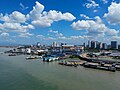
George Town is the capital of the Malaysian state of Penang and the core city of the George Town Conurbation, Malaysia's second largest metropolitan area with a population of 2.84 million and the second highest contributor to the country's GDP. The city proper spans an area of 306 km2 (118 sq mi) encompassing Penang Island and surrounding islets, and had a population of 794,313 as of 2020.

<span class="mw-page-title-main">Butterworth, Seberang Perai</span> Town in Malaysia

Butterworth is the city centre of Seberang Perai in the Malaysian state of Penang. It lies about 3 km (1.9 mi) east of George Town, the capital city of Penang, across the Penang Strait. As of 2020, Butterworth had a total population of 80,378 residents.

<span class="mw-page-title-main">Bukit Mertajam</span> Suburb of Seberang Perai and district capital in Penang, Malaysia

Bukit Mertajam is a suburb of Seberang Perai in the Malaysian state of Penang. It also serves as the seat of the Central Seberang Perai District. As of 2020, Bukit Mertajam had a population of 12,079.

<span class="mw-page-title-main">Juru, Malaysia</span> Suburb of Seberang Perai in Penang, Malaysia

Juru is a suburb of Seberang Perai in the Malaysian state of Penang. It is located southwest of Bukit Mertajam and south of Bukit Tengah. Juru is served by the North–South Expressway Northern Route and connects the town to Butterworth and Bayan Lepas, the latter being located on Penang Island.

<span class="mw-page-title-main">Permatang Pauh</span> Neighbourhood of Seberang Perai in Penang, Malaysia

Permatang Pauh is a residential neighbourhood within the city of Seberang Perai in the Malaysian state of Penang. There are two institutions of higher learning located in Permatang Pauh, namely a campus of Universiti Teknologi MARA (UiTM) and Politeknik Seberang Perai at Bandar Perda.

<span class="mw-page-title-main">Nibong Tebal</span> Suburb of Seberang Perai in Penang, Malaysia

Nibong Tebal is a suburb of Seberang Perai in the Malaysian state of Penang. Located at the northern bank of the Kerian River within the Southern Seberang Perai District, it is the southernmost populated place of Penang. Nibong Tebal contained a population of 1,425 as of 2020.

<span class="mw-page-title-main">Perai</span> Suburb of Seberang Perai in Penang, Malaysia

Perai is a suburb of Seberang Perai in the Malaysian state of Penang. It lies at the southern bank of the Perai River and borders Butterworth to the north.

<span class="mw-page-title-main">Seberang Jaya</span> Suburb of Seberang Perai in Penang, Malaysia

Seberang Jaya is a suburb of Seberang Perai in the Malaysian state of Penang. Located at the southern bank of the Perai River and east of Perai proper, the area was developed in the 1970s. Since then, Seberang Jaya has evolved into a booming area, with various commercial and retail developments.

<span class="mw-page-title-main">Batu Kawan</span> Suburb of Seberang Perai in Penang, Malaysia

Batu Kawan is an island and suburb of Seberang Perai in the Malaysian state of Penang. It is geographically separated from the rest of Seberang Perai by the Jawi and Tengah rivers. As of 2020, Batu Kawan contained a population of 11,409.

<span class="mw-page-title-main">History of Penang</span> History of the Malaysian state of Penang

The State of Penang, one of the most developed and urbanised Malaysian states, is located at the nation's northwest coast along the Malacca Strait. Unlike most Malaysian states, the history of modern Penang was shaped by British colonialism, beginning with the acquisition of Penang Island from the Sultanate of Kedah by the British East India Company in 1786. Developed into a free port, the city state was subsequently governed as part of the Straits Settlements, together with Singapore and Malacca; the state capital, George Town, briefly became the capital of this political entity between 1826 and 1832. By the end of the 19th century, George Town prospered and became one of the major entrepôts in Southeast Asia.

<span class="mw-page-title-main">Penang Strait</span> Strait in Malaysia

The Penang Strait is an 11 kilometre-wide strait that separates Penang Island from mainland Malay Peninsula. Penang Island is to the west of the channel, while Seberang Perai, the mainland half of the State of Penang, is to the east. The northern and southern ends of the channel join the Strait of Malacca, one of the world's busiest maritime routes.

<span class="mw-page-title-main">Transport in Penang</span>

The State of Penang in Malaysia, home to the country's third largest city as well as part of Malaysia's second most populous conurbation, has a relatively well-developed transport infrastructure. The city-state is well-connected by land, air and sea; the Penang International Airport is one of Malaysia's busiest, while the Port of Penang is the main harbour and transshipment hub within northern Malaysia. The North–South Expressway, the main highway along western Peninsular Malaysia, runs through Penang, while the two geographically separate halves of the state are now linked by two bridges and a ferry service.

<span class="mw-page-title-main">Central Seberang Perai District</span> District of Malaysia in Penang

The Central Seberang Perai District is a district in the state of Penang, Malaysia. It covers an area of 238 square kilometres, and had a population of 371,975 at the 2010 Census. The district is bordered by Perai River which separates North Seberang Perai in the north, Junjong River which separates South Seberang Perai in the south, Kedah state border in the east and South Channel which separates Penang Island. Juru River also flows through the district. The capital of this district is Bukit Mertajam. Other localities in Central Seberang Perai include Permatang Pauh, Penanti, Bukit Tengah, Bukit Minyak, Juru, Alma, Machang Bubok and Permatang Tinggi. The entertainment, eatery and automobile venue of Autocity is also located in this district. Heavy industrial areas cover most parts of Central Seberang Perai.

<span class="mw-page-title-main">South Seberang Perai District</span> District of Malaysia in Penang

The South Seberang Perai District is a district in Penang, Malaysia. It covers an area of 242 square kilometres, and had a population of 184,007 at the 2020 Census. The district is bordered by Junjong River that separates Central Seberang Perai in the north, Kedah state border in the east, Perak state border in the south and the South Channel that separates Penang Island. Rivers that flow through South Seberang Perai are Junjong River, Jawi River and Kerian River. The capital of this district is Sungai Jawi and the largest town is Nibong Tebal. Other towns such as Batu Kawan, Bukit Tambun, Simpang Ampat, Sungai Bakap and Valdor are also located in this district. South Seberang Perai is thriving with the fishing industry and agriculture. Oil palm plantations covers most parts of the area.

<span class="mw-page-title-main">Seberang Perai City Council</span> Local government of the municipality of Seberang Perai in Penang

The Seberang Perai City Council is the city council which administers Seberang Perai, the mainland half of the Malaysian state of Penang. This agency is under the purview of the Penang state government.

<span class="mw-page-title-main">Simpang Ampat, Seberang Perai</span> Neighbourhood of Seberang Perai in Penang, Malaysia

Simpang Ampat is a residential neighbourhood within the city of Seberang Perai in the Malaysian state of Penang.

Bukit Tengah is a suburb of Seberang Perai in the Malaysian state of Penang. This area is situated very close to the North–South Expressway. The town is within a proper of a larger town of Bukit Mertajam, which shares the same postcode of 14000.

<span class="mw-page-title-main">Greater Penang Conurbation</span> Metropolitan area in Malaysia

The Greater Penang Conurbation, also known as the George Town Conurbation, is the built-up urban or metropolitan area within and around the Malaysian state of Penang. Encompassing all of Penang, and parts of the neighbouring states of Kedah and Perak, the conurbation was home to over 2.84 million people as of 2020, the second largest in the country after the Klang Valley.

Kam Suan Pheng is a retired Malaysian lecturer, soil scientist, geospatial expert and environmentalist. Hailing from the state of Penang, she played an instrumental role in the creation of the Penang Geographic Information System (PeGIS).

References

  1. 1 2 3 4 "MyCensus 2020: Mukim/Town/Pekan". Department of Statistics Malaysia : 174–175. February 2024. ISBN   9789672537069.
  2. 1 2 3 4 5 6 7 8 9 10 11 12 Leng, Hin-Seak (May 1969). "Political leadership in a plural society: Penang in the 1960's" (PDF). Australian National University .
  3. 1 2 3 4 5 6 "History". Seberang Perai City Council . Retrieved 2 February 2024.
  4. 1 2 "Management group". Seberang Perai City Council . Retrieved 5 February 2024.
  5. 1 2 3 4 5 6 7 8 "Key Findings of Population and Housing Census of Malaysia 2020" (pdf) (in Malay and English). Department of Statistics, Malaysia. ISBN   978-967-2000-85-3.
  6. 1 2 Edmund Lee (20 May 2019). "New era of development for Seberang Perai with 'city status' recognition". Buletin Mutiara. Retrieved 5 February 2024.
  7. 1 2 3 4 5 6 Ooi, Keat Gin (2015). "Disparate Identities: Penang from a Historical Perspective, 1780–1941" (PDF). Kajian Malaysia. 33 (Supp. 2): 27–52. ISSN   0127-4082 . Retrieved 7 March 2023.
  8. 1 2 3 4 5 6 7 8 9 10 11 12 13 14 Chan, Wai Yeap. "The History of Bukit Mertajam (1800-1957): From Agrarian Town to Central Hub of Northern Malaya". Penang Institute via Academia.edu.
  9. 1 2 3 Hasni, Rosmiyati (2015). "Predicting Seberang Perai housing land pattern in 2017" (PDF). Universiti Sains Malaysia .
  10. 1 2 3 4 5 6 7 8 Samat, Narimah (22 July 2013). "Urban Expansion and its Impact on Local Communities: A Case Study of Seberang Perai, Penang, Malaysia". Universiti Sains Malaysia . ISSN   0128-7702 via ResearchGate.
  11. "Table 3.5: Total Container Throughput By Ports, Malaysia, 2022" (PDF). Ministry of Transport . 21 February 2023.
  12. 1 2 3 Athukorala, Prema-chandra. "Growing with Global Production Sharing: The Tale of Penang Export Hub, Malaysia" (PDF). Australian National University .
  13. Liew, Jia Teng (18 November 2021). "Cover Story: Why companies are flocking to Batu Kawan Industrial Park". The Edge . Retrieved 5 February 2024.
  14. 1 2 3 "Penang bridges". Institution of Civil Engineers . Retrieved 17 December 2023.
  15. 1 2 Kharas, Homi (2010). "Cities, people & the economy: A study on positioning Penang" (PDF). World Bank . Khazanah Nasional. ISBN   978-983-44193-3-2.
  16. 1 2 3 Joshua Woo Sze Zeng (9 July 2020). "Exploring a transit-oriented development (TOD) Framework for Penang's urban growth" (PDF). Penang Institute (7).
  17. 1 2 3 "Seberang Perai gains city status". Malay Mail . 16 September 2019. Retrieved 2 February 2024.
  18. 1 2 Allers, Charles (2014). Anwar Ibrahim: Evolution of a Muslim Democrat. Monsoon Books. ISBN   9789814423724.
  19. 1 2 Ivy Soon (2016). Seberang Perai: Stories from Across the Sea. Star Media Group. ISBN   9789839512571.
  20. 1 2 Opalyn Mok (21 July 2017). "Bringing life back to the river that Perai is named after". Malay Mail . Retrieved 14 January 2024.
  21. 1 2 Shahidan, Shaiful (2 July 2018). "Tapak Guar Kepah: Bukti perkuburan masyarakat Neolitik di dalam timbunan cangkerang laut" [Guar Kepah: Evidence of Neolithic Burial in Shell Mound]. Universiti Sains Malaysia (in Malay). 11 (2).
  22. Opalyn Mok (10 May 2019). "5,000-year-old 'Penang Woman' on display at archeological site in Guar Kepah". Malay Mail . Retrieved 2 February 2024.
  23. 1 2 Sarjit Singh, Meljev Singh Sidhu (2018). "Building materials and structural foundations in the Bujang Valley and comparisons with four regional settlements" (PDF). Universiti Sains Malaysia .
  24. Murphy, Stephen (2017). "Revisiting the Bujang Valley: A Southeast Asian entrepôt complex on the maritime trade route" (PDF). Journal of the Royal Asiatic Society : 2.
  25. Hill, Ronald David (23 November 1839). "Plan of Prince of Wales Island and Province Wellesley". National Archives of Singapore . Ms copy by Poon Puay Kee. Archived from the original on 16 October 2022. Retrieved 10 January 2024.
  26. Moniot, Jules Michael (1860). "Map of Prince of Wales Island, or Pulo Penang and Province Wellesley including a Careful Survey of the South Channel". National Archives of Singapore . Archived from the original on 18 October 2022. Retrieved 10 January 2024.
  27. Stanford, Edward (1870). "Map of Prince of Wales Island and Province Wellesley, Straits Settlements". National Archives of Singapore . Revised by Major J.F.A.McNair. Archived from the original on 18 October 2022. Retrieved 10 January 2024.
  28. Allen, J. De V.; Stockwell, A. J.; Wright, L. R. (1981). "Documents Archive - Pangkor Engagement of 1874". Empire in Asia. Annotated by Aloysius Ng. National University of Singapore. Archived from the original on 25 November 2016. Retrieved 30 January 2023.
  29. Samuel Wee, Tien Wang (1992). "British strategic interests in the Straits of Malacca 1786-1819" (PDF). Simon Fraser University .
  30. Jenkins, Gwynn (2008). Contested Space: Cultural Heritage and Identity Reconstructions: Conservation Strategies Within a Developing Asian City. LIT Verlag Münster. ISBN   978-3-8258-1366-6.
  31. Jenkins, Gwynn (2008). Contested Space: Cultural Heritage and Identity Reconstructions: Conservation Strategies Within a Developing Asian City. LIT Verlag Münster. ISBN   978-3-8258-1366-6.
  32. Marcus Langdon (2013). Penang: The Fourth Presidency of India. 1805-1830. Volume One: Ships, Men and Mansions. Areca Books. pp. 219, 222. ISBN   9789675719073.
  33. Zhao, Long (2 December 2018). "The townscape evolution of historic port settlement of George Town, Pulau Pinang, Malaysia" (PDF). University of Putra Malaysia . 11.
  34. Mior Hamzah, Mior Ahmad Noor. "Hubungan Melayu-Siam: Melihat kepada persoalan sempadan di Kedah" (PDF). Universiti Utara Malaysia (in Malay): 42.
  35. Ahmat, Sharom. "Kedah-Siam relations, 1821-1905" (PDF). Siam Society .
  36. Aloysius Ng. "Documents Archive - Pangkor Engagement of 1874". National University of Singapore. Archived from the original on 25 November 2016. Retrieved 30 January 2023.
  37. "RAF Station Butterworth Malaya (1939-1957)" (PDF). Air Force Association - New South Wales.
  38. Farrell, Brian (2008). "Malayan Campaign 1941-42: Lessons for One SAF" (PDF). Ministry of Defence (Singapore) . Government of Singapore.
  39. 1 2 3 Barber, Andrew (2010). Penang At War : A History of Penang During and Between the First and Second World Wars 1914–1945. AB&B.
  40. 1 2 "Plan to split rural board". Singapore Standard . 20 October 1953. Retrieved 2 February 2024.
  41. "Town Councils planned". Singapore Free Press . 10 December 1952. Retrieved 2 February 2024.
  42. "Ranchangan gabongan majlis2 tempatan". Berita Harian (in Malay). 19 April 1960. Retrieved 2 February 2024.
  43. 1 2 "Province gets new district council". The Straits Budget. 19 April 1961. Retrieved 2 February 2024.
  44. Chin, Yee Whah (July 2006). "Penang Small and Medium Enterprises: Struggle, Accommodation and Challenges" (PDF). Universiti Sains Malaysia .
  45. 1 2 3 Sue-Ching Jou, Hsin-Huang Michael Hsiao, Natacha Aveline-Dubach (2014). Globalization and New Intra-Urban Dynamics in Asian Cities. Taipei: National Taiwan University. ISBN   9789863500216.
  46. "Hot on Singapore's heels". The Business Times . 3 July 1992. Retrieved 2 February 2024.
  47. Tern Chern, Lo (19 October 2022). "Rise of Batu Kawan". The Star . Retrieved 2 February 2024.
  48. 1 2 3 4 Abd. Rahman, Abdul Hadi (September 2000). "Coastal Sedimentation and Recent Coastline Changes Along the Seberang Perai Coast, Pulau Pinang" (PDF). University of Malaya .
  49. 1 2 3 "Draf Rancangan Tempatan Seberang Perai 2030" (PDF). Seberang Perai City Council (in Malay).
  50. Lopez, Leslie (9 April 2021). "Murky politics as two Malaysian states - Penang and Kedah - clash over water". The Straits Times . Retrieved 5 February 2024.
  51. Mohd Yunus, Zubir (16 October 2016). "Kerian menjadi titik sempadan Perak, Kedah, Pulau Pinang". Berita Harian (in Malay). Retrieved 5 February 2024.
  52. Dermawan, Audrey (29 May 2022). "The sad state of Penang rivers". New Straits Times . Retrieved 5 February 2024.
  53. "SYNOP/BUFR observations. Data by months". Meteomanz. Retrieved 22 March 2024.
  54. 1 2 3 Yaacob, Zainulfaqar (25 September 2019). "Kompleks pentadbiran MBSP kini dinamakan 'Menara Bandaraya'". Buletin Mutiara (in Malay). Retrieved 8 February 2024.
  55. 1 2 Goh, Ban Lee (25 February 2019). "Butterworth set to soar". The Sun . Retrieved 8 February 2024.
  56. 1 2 3 Yeng, Ai Chun (22 November 2008). "Former MPSP building up for sale". The Star . Retrieved 8 February 2024.
  57. "First batch of commissioners appointed: Singapore bodies to be consulted". The Straits Budget. 5 June 1913. p. 12. Retrieved 8 February 2024.
  58. "Struktur Pentadbiran". Seberang Perai City Council (in Malay). 4 October 2021. Retrieved 8 February 2024.
  59. "Background". Penang Island City Council . Retrieved 30 December 2023.
  60. "Alliance sweeps in". The Straits Budget. 31 May 1961. p. 9. Retrieved 8 February 2024.
  61. Abdullah, Saifuddin. "George Town: Malaysia's First Local Democracy". Penang Institute. Retrieved 19 December 2023.
  62. "Deputy state secretary takes over as Seberang Perai mayor". Free Malaysia Today . 31 December 2021. Retrieved 8 February 2024.
  63. Akmal, Riadz (9 July 2021). "Impressive feedback for proposed 2030 Seberang Perai planning blueprint". Buletin Mutiara. Retrieved 8 February 2024.
  64. "MBSP Budget Focuses on Building Green and Clean City". The Star . 5 October 2022. Retrieved 30 December 2023.
  65. Caroline, Jim (January 2015). "Good governance and government sector performance at Majlis Perbandaran Seberang Perai" (PDF). Universiti Utara Malaysia .
  66. 1 2 3 "Developer ready to face probe" (PDF). New Straits Times . 3 December 2008. Retrieved 8 February 2024.
  67. 1 2 3 4 5 Hutchinson, Francis (23 November 2023). "The August Poll in Penang: A Perspective on Pakatan, its Partners and its Prospects" (PDF). ISEAS – Yusof Ishak Institute .
  68. "Court Directory". penangbar.org. Penang Bar Committee. 15 January 2018. Archived from the original on 3 December 2016. Retrieved 22 June 2018.
  69. 1 2 "My Local Stats Seberang Perai Utara Pulau Pinang 2022". Department of Statistics Malaysia . November 2023. ISSN   2735-2498.
  70. 1 2 "My Local Stats Seberang Perai Tengah Pulau Pinang 2022". Department of Statistics Malaysia . November 2023.
  71. 1 2 "My Local Stats Seberang Perai Selatan Pulau Pinang 2022". Department of Statistics Malaysia . November 2023. ISSN   2735-251X.
  72. A. Vlieland, C. (1932). "British Malaya: A report on the 1931 census and on certain problems of vital statistics". Straits Settlements : 129 via Department of Statistics Malaysia.
  73. V. Del Tufo, M. "Malaya: A report on the 1947 census of population". Federation of Malaya : 136 via Department of Statistics Malaysia.
  74. "1957 population census report no. 3: State of Penang". Department of Statistics, Federation of Malaya. Kuala Lumpur: 4–6. 11 July 1959 via Department of Statistics Malaysia.
  75. Chander, R. "1970 population and housing census of Malaysia". Department of Statistics Malaysia . Kuala Lumpur: 53–54.
  76. Khoo, Teik Huat (June 1984). "1980 population and housing census of Malaysia: Population report for administrative districts". Department of Statistics Malaysia . Kuala Lumpur: 123–129.
  77. 1 2 Khoo, Soo Gim (February 1995). "Population and housing census of Malaysia 1991: General report of the population census". Department of Statistics Malaysia . 2. Kuala Lumpur: 25. ISSN   1394-3642.
  78. Abdul Rahman, Shaari (September 2004). "Population and housing census of Malaysia 2000: Census atlas". Department of Statistics Malaysia . Putrajaya: 79. ISSN   1394-6250.
  79. "Population and housing census of Malaysia: Population profile by parliament and state legislative assembly areas 2010". Department of Statistics Malaysia . Putrajaya: 17–19. May 2012.
  80. "City scan Penang, Malaysia: City resilience program" (PDF). World Bank .
  81. Rena Lim (10 November 2018). "Mainland holds Penang's future". The Star . Retrieved 5 February 2024.
  82. Goh, Ban Lee (7 October 2019). "Seberang Perai comes of age". The Sun . Retrieved 5 February 2024.
  83. Susan Loone (29 August 2018). "Penang CM rolls out vision, says state's future is in Seberang Prai". Malaysiakini . Retrieved 10 February 2024.
  84. Akmal, Riadz (4 May 2023). "Penang govt intensifies efforts for balanced development in Seberang Perai and Penang island". Buletin Mutiara. Retrieved 10 February 2023.
  85. Christopher Tan (9 March 2021). "Penang Bay – A potential SDG City Zone to unlock opportunities". Buletin Mutiara. Retrieved 11 February 2024.
  86. 1 2 "No more industrial land in Seberang Perai, says exco man". Free Malaysia Today . 28 June 2021. Retrieved 10 February 2024.
  87. 1 2 3 "Final External Trade Statistics 2023". Department of Statistics Malaysia : 89. July 2023. ISSN   2180-1827.
  88. 1 2 3 Filmer, Andrea (March 2019). "Batu Kawan Rising". Penang Monthly. Retrieved 10 February 2024.
  89. "Batu Kawan becomes hotspot for new retail". The Vibes. 20 May 2022. Retrieved 10 February 2024.
  90. "Penang Tourism Master Plan 2021–2030" (PDF). Penang state government . May 2021. ISBN   9789671966105.
  91. Chin, Yee Whah (July 2006). "Penang Small and Medium Enterprises: Struggle, Accommodation and Challenges" (PDF). Universiti Sains Malaysia .
  92. 1 2 3 4 Athukorala, Prema-chandra. "Growing with Global Production Sharing: The Tale of Penang Export Hub, Malaysia" (PDF). Australian National University .
  93. Ooi, Kee Beng (December 2009). "Tun Lim Chong Eu: The Past is Not Passé". Penang Monthly. Archived from the original on 8 August 2020. Retrieved 30 November 2017.
  94. Peter Nijkamp, Amitrajeet A. Batabyal (2016). Regional Growth and Sustainable Development in Asia. Springer. ISBN   9783319275895.
  95. Christopher Tan (3 April 2021). "Penang strives to drive industry forward". Buletin Mutiara. Retrieved 10 February 2024.
  96. "Hot on Singapore's heels". The Business Times . 3 July 1992. Retrieved 2 February 2024.
  97. "Manufacturing Companies In Perai, Pulau Pinang, Malaysia". Dun & Bradstreet . Retrieved 31 January 2024.
  98. Rafee, Hannah (20 March 2020). "Steady climb in Penang industrial segment". The Edge . Retrieved 10 February 2024.
  99. 1 2 3 "Laporan Sosioekonomi Negeri Pulau Pinang 2022". Department of Statistics Malaysia . August 2023. ISSN   2600-9854.
  100. 1 2 Dermawan, Audrey (24 August 2017). "Design Village Penang aims to draw in some 2.5 million visitors this year". New Straits Times . Retrieved 10 February 2024.
  101. "Higher FY20, FY21 profits seen for Sunway REIT". The Edge . 19 March 2019. Retrieved 10 February 2024.
  102. Vimal, Kevin (11 April 2022). "Seberang Perai set to become the next big thing in tourism". Buletin Mutiara. Retrieved 10 February 2024.
  103. "Penang Tourism Master Plan 2021-2030" (PDF). Penang state government . ISBN   9789671966105.
  104. 1 2 3 Yusof, Ayisy (8 February 2021). "Penang Port's NBCT gazetted as a free commercial zone". New Straits Times . Retrieved 10 February 2024.
  105. 1 2 "Table 3.5: Total Container Throughput By Ports, Malaysia, 2022" (PDF). Ministry of Transport . 21 February 2023.
  106. Stephanie Kee (January 2018). "Penang – A Rice Bowl State under Threat?". Penang Monthly. Retrieved 10 February 2024.
  107. Opalyn Mok (23 February 2017). "Spurring the local economy in Seberang Perai through agro-industry". Malay Mail . Retrieved 10 February 2024.
  108. "Penang's average rice production highest in country for six straight years". The Sun . 22 November 2023. Retrieved 10 February 2024.
  109. 1 2 Rachel Yeoh (24 May 2022). "Bandar Cassia dubbed Penang's new art city". The Vibes. Retrieved 11 February 2024.
  110. Hilmy, Imran (10 January 2023). "'Painting' Seberang Prai town red". The Star . Retrieved 11 February 2024.
  111. Sharma, M. Sivanantha (31 July 2022). "Over 30,000 attend St Anne's Feast celebrations in Penang". The Star . Retrieved 11 February 2024.
  112. Vimal, Kevin (16 September 2022). "Never let differences separate us, says CM Chow". Buletin Mutiara. Retrieved 11 February 2024.
  113. Opalyn Mok (2 February 2017). "A Butterworth art scene? It's already here". Malay Mail . Retrieved 11 February 2024.
  114. Lo, Tern Chern (16 February 2017). "Butterworth Art Walk in alley aimed at getting visitors to stop and ponder". The Star . Retrieved 11 February 2024.
  115. "Butterworth Fringe Festival draws 30,000 with local and international cultural acts". The Sun . 27 December 2023. Retrieved 11 February 2024.
  116. Akmal, Riadz (24 July 2022). "Penang International Paddy Festival draws thousands of visitors". Buletin Mutiara. Retrieved 11 February 2024.
  117. 1 2 "Penang Meeting Planners Guide 2022-23" (PDF). Penang Convention & Exhibition Bureau.
  118. Lo, Tern Chern (27 June 2020). "Penang seeks RM67mil for stadium". The Star . Retrieved 11 February 2024.
  119. "Sports centre in Seberang Prai to be ready next year". The Star . 23 July 2022. Retrieved 11 February 2024.
  120. Liew, Jia Xian (20 September 2022). "Facelift for pool to make a splash". The Star . Retrieved 11 February 2024.
  121. Sulong, Jasni (2015). "Pondok education in Seberang Perai: Its evolution and uniqueness" (PDF). Universiti Sains Malaysia .
  122. 1 2 "List of Institutes of Higher Learning" (PDF). Invest Penang. Retrieved 9 December 2023.
  123. Jeremy Tan (28 June 2022). "Varsity college opens new campus in Batu Kawan industrial park". The Star . Retrieved 12 February 2024.
  124. "High employability education by Plymouth University". The Star . 8 January 2023. Retrieved 12 February 2024.
  125. Akmal, Riadz (22 November 2021). "Butterworth Digital Library Clinches Two Awards". Buletin Mutiara. Retrieved 4 February 2024.
  126. Akmal, Riadz (27 May 2023). "First digital library in Bukit Mertajam set for completion next year". Buletin Mutiara. Retrieved 12 February 2024.
  127. Dewi, K. Kasturi (7 August 2023). "Health boost for northern region". The Star . Retrieved 13 February 2024.
  128. 1 2 "Penang's Healthcare Facilities". Penang Institute. Retrieved 10 December 2023.
  129. "Hospital". Seberang Perai City Council . 31 January 2019. Retrieved 13 February 2024.
  130. Mulyanto, Randy (21 November 2023). "Malaysia's Penang Lures Medical Tourists from Indonesia". Nikkei, Inc. Retrieved 7 December 2023.
  131. Cheryl Poo (16 August 2023). "Recovery of Malaysia's Medical Tourism Sector in the Bag, More Markets Targeted". The Edge . Retrieved 6 December 2023.
  132. Hilmy, Imran (28 November 2023). "Penang Health Dept Installs 168 Automated External Defibrillators". The Star . Retrieved 26 December 2023.
  133. Akmal, Riadz (3 April 2023). "'Heart Saver Penang' Initiative to Increase Coverage of AED". Buletin Mutiara. Retrieved 4 February 2024.
  134. "Study on traffic control and management system of Malaysian expressways and toll highways" (PDF). Malaysian Highway Authority . December 1989 via Japan International Cooperation Agency.
  135. 1 2 "Urban Transport Study in Greater Metropolitan Areas of George Town, Butterworth and Bukit Mertajam, Malaysia: Progress Report (Phase 1)" (PDF). Japan International Cooperation Agency . August 1979.
  136. Cripps, Karla (14 July 2023). "Famed luxury train is returning to Southeast Asia with two new routes". CNN. Retrieved 15 October 2023.
  137. "Annual Report 2021" (PDF). Highway Authority Malaysia. 2021.
  138. 1 2 Kaur, Sharen (18 February 2020). "Phase 2 of Penang Sentral to go full swing next year". New Straits Times . Retrieved 14 February 2024.
  139. "Rapid Penang - Bus". MyRapid. Retrieved 10 December 2023.
  140. Ooi, Kee Beng (2010). Pilot Studies for a New Penang. Singapore: Institute of Southeast Asian Studies. ISBN   9789814279697.
  141. "Loke: Federal Gov't Takes Over Penang LRT Mutiara Line Project from State Gov't". The Sun . 29 March 2024. Retrieved 29 March 2024.
  142. "Public Transport - LRT & BRT". Penang Infrastructure Corporation. Retrieved 14 February 2024.
  143. 1 2 3 Azmi, Zuriati (2015). "ASEAN Economic Community 2015: A case study on the potential impacts to Penang Port Sdn Bhd" (PDF). Universiti Utara Malaysia .
  144. Jeremy Tan (29 November 2023). "Nostalgia of Voyages Past for Penang's Iconic Ferries". The Star . Retrieved 27 December 2023.
  145. Opalyn Mok (8 December 2023). "Penang Port CEO Says Extra Ferry Open for Private Charter". Malay Mail . Retrieved 10 December 2023.
  146. "New Penang Ferry Service Operational from Today". The Sun . 7 August 2023. Retrieved 27 December 2023.
  147. "Location of approved loans and technical assistance projects 1968" (PDF). Asian Development Bank : 16. February 1969.
  148. "See us in court, Chow tells Kedah over Sg Muda feud". The Vibes. 10 March 2021. Retrieved 14 February 2024.
  149. "PBAPP draws up crisis management plan to tackle Sg Muda incidents". The Star . 4 October 2023. Retrieved 14 February 2024.
  150. "Statistics". Penang Water Supply Corporation . Retrieved 29 December 2023.
  151. "Penang Dams & Effective Capacity". Penang Water Supply Corporation . Retrieved 29 December 2023.
  152. "No problems with Mengkuang Dam: PBAPP". The Vibes. 24 October 2023. Retrieved 14 February 2024.
  153. "Electricity and Gas Supply Infrastructure Malaysia" (PDF). Suruhanjaya Tenaga . Putrajaya.
  154. Ong, K. H. (13 February 2023). "Penang island Completes Converting over 33,000 Streetlights to LEDs, State Govt to Seek Incentives from Ministry". Buletin Mutiara. Retrieved 29 December 2023.
  155. "Penang First State to Install Fibre Optic Infrastructure as Basic Utility, Says Committee Chairman". Northern Corridor Economic Region . 21 December 2020. Retrieved 29 December 2023.
  156. Ahirudin, Ahirul (9 September 2022). "Penang first in northern Malaysia to get 5G coverage". The Vibes. Retrieved 14 February 2024.
  157. "Diplomatic and consular list November 2023". Ministry of Foreign Affairs, Malaysia . November 2023.
  158. "Fremantle fast facts". City of Fremantle . Retrieved 15 January 2024.
  159. "Closing Remarks Municipal President MPSP" (PDF). Seberang Perai City Council . 29 August 2014.
  160. "Biographical Notes: Wong Pow Nee (7 November 1911 – 31 August 2002) – Malaysian politician" (PDF). ISEAS – Yusof Ishak Institute .
  161. "Tun Mohamed Salleh Ismael". Royal Malaysia Police . Retrieved 16 January 2024.
  162. "Biografi Tun Abdul Hamid Mohamad". Federal Court of Malaysia . 24 July 2023. Retrieved 16 January 2024.
  163. "Pejabat Tuan Yang Terutama". Penang state government . Retrieved 16 January 2024.
  164. "Profile: Mat Sabu, the crowd-puller". New Straits Times . 3 December 2022. Retrieved 16 January 2024.
  165. Soo, Wern Jun (5 July 2018). "Age no longer a factor, says deputy to youngest minister". Free Malaysia Today . Retrieved 16 January 2024.
  166. 1 2 Saaid, Hamdan (22 November 2021). "Jin Wei-June Wei main beregu campuran?". Harian Metro . Retrieved 16 January 2024.
  167. "Environment". Department of Statistics Singapore. Retrieved 29 December 2023.
  168. "Exchange Rates". Central Bank of Malaysia . Retrieved 21 February 2024.