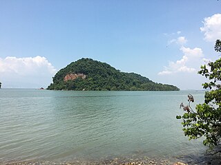
Jerejak Island is a 3.62 km2 (362 ha) islet off the eastern coast of Penang Island in the Malaysian state of Penang. It is also a short ferry ride from Bayan Lepas, a suburb of George Town. It was formerly the main leper asylum for the Straits Settlements (1868), a Quarantine Station (1875) and a penal colony (1969).

Melaka Island is a man-made islet approximately 0.5 km off the coast of Malacca City – the capital city of the Malaysian state of Malacca, just south of its business district of Taman Melaka Raya. It is formed from the amalgamation of two offshore islets named Jawa Island in the mid-1990s, when the Malacca State Government under then Chief Minister, Abdul Rahim Thamby Chik was planning to turn it into a "Malacca Manhattan" for business and recreational purposes.

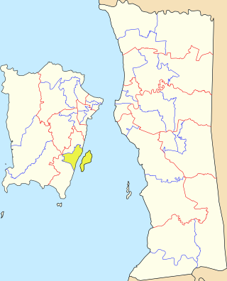
Aman Island is an islet in South Seberang Perai District, Penang, Malaysia, located off the coast of Seberang Perai.

Betong Island is a group of two islets off the southwestern coast of Penang Island in the Malaysian state of Penang. The islets have a combined land mass of 7 acres (0.028 km2). Although they are uninhabited, there is a small fish farm on the larger islet, and they are visited by anglers and fishermen in the daytime.
Gedung Island is an islet in South Seberang Perai District, Penang, Malaysia, located off the coast of Seberang Perai.

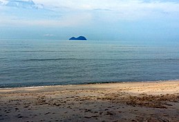
Rimau Island is an islet off the southeastern tip of Penang Island in the Malaysian state of Penang. The islet was once referred to by French cartographers as Île Cayment.

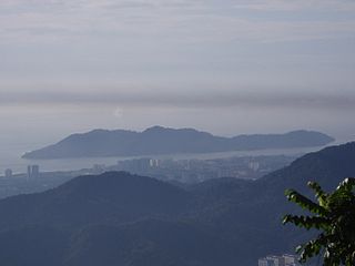
The Penang Strait is an 11 kilometre-wide strait that separates Penang Island from mainland Malay Peninsula. Penang Island is to the west of the channel, while Seberang Perai, the mainland half of the State of Penang, is to the east. The northern and southern ends of the channel join the Strait of Malacca, one of the world's busiest maritime routes.
The Penang Island City Council is the local government that administers the city of George Town, which includes the entirety of Penang Island. The city council, which has jurisdiction over an area of 306 km2 (118 sq mi), falls under the purview of the Penang state government.

The Seberang Perai City Council is the local government that administers the city of Seberang Perai, which encompasses the mainland half of the Malaysian state of Penang. The city council, which has jurisdiction over an area of 748 km2 (289 sq mi), falls under the purview of the Penang state government.
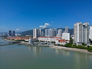
Tanjong Pinang is a suburb within the city of George Town in the Malaysian state of Penang. It lies 4.5 km (2.8 mi) northwest of the city centre and was created on land reclaimed off Tanjong Tokong in the 1990s. The suburb also encompasses Gurney Bay and the ongoing reclamation project of Andaman Island.
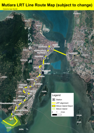
The Mutiara LRT line is a proposed light rapid transit system in Penang. The 28 kilometres (17 mi) line is planned to connect George Town's city centre with its southern suburbs of Jelutong, Gelugor and Bayan Lepas, with a link towards Seberang Perai across the Penang Strait. Once completed, it is owned by the Mass Rapid Transit Corporation (MRTC). The line, a component of the Penang Transport Master Plan (PTMP), is projected to contain 21 stations. Construction of the line is expected to begin in December 2024, and will be completed by 2030.

Tikus Island is an islet off the northern coast of Penang Island in the Malaysian state of Penang. Located nearly 770 m off Tanjung Bungah, a suburb of George Town, this uninhabited outcrop is now home to a solar-powered lighthouse. This active lighthouse marks the northern entrance to the Penang Strait and hence, the Port of Penang.

Pulau Betong is a state constituency in Penang, Malaysia, that has been represented in the Penang State Legislative Assembly since 2004. It covers a part of the western half of Penang Island that includes the town of Balik Pulau.

Bayan Lepas is a state constituency in Penang, Malaysia, that has been represented in the Penang State Legislative Assembly since 1959. It covers the southwestern corner of Penang Island, including the old quarter of the town of Bayan Lepas and fishing villages along the island's southern coast.

Batu Maung is a state constituency in Penang, Malaysia, that has been represented in the Penang State Legislative Assembly since 2004. It covers the southeastern corner of Penang Island, including the eponymous town of Batu Maung, the Penang International Airport and the newer parts of Bayan Lepas.
Pantai Jerejak is a state constituency in Penang, Malaysia, that has been represented in the Penang State Legislative Assembly since 2004. It covers a portion of southeastern Penang Island, including Bayan Baru and the northern half of the Bayan Lepas Free Industrial Zone.

Lovers' Isle is an islet in Southwest Penang Island District, Penang, Malaysia, located off the northern coast of Penang Island. Located off Batu Ferringhi, a suburb of the city of George Town, this uninhabited rocky outcrop was where the first European sailors to reach what is now Penang arrived in the 16th century.
Konet Island is an islet located 100 metres off the shores of Telok Gong in Kuala Sungai Baru, Malacca, Malaysia. It is rich with corals and colourful ornamental fishes, connected to the mainland by a tombolo and is accessible by foot at low tide. Similar to Besar Island and according to local legends, the island is also believed to be the home of the elves known as Orang bunian. Another islet with similar feature, Keramat Island, is located 50 metres west of this islet.
Andaman Island is a 760-acre (3.1 km2) man-made islet off the northeastern coast of Penang Island in the Malaysian state of Penang. Located just 760 m (2,490 ft) off the shoreline of Tanjong Pinang within the city of George Town, it is being reclaimed by local developer Eastern and Oriental Berhad as an integrated mixed-use precinct with a gross development value of RM17 billion.