
Sabah is a state of Malaysia located on the northern portion of Borneo, in the region of East Malaysia. Sabah has land borders with the Malaysian state of Sarawak to the southwest and Indonesia's North Kalimantan province to the south. The Federal Territory of Labuan is an island just off Sabah's west coast. Sabah shares maritime borders with Vietnam to the west and the Philippines to the north and east. Kota Kinabalu is the state capital and the economic centre of the state, and the seat of the Sabah State government. Other major towns in Sabah include Sandakan and Tawau. The 2020 census recorded a population of 3,418,785 in the state. It has an equatorial climate with tropical rainforests, abundant with animal and plant species. The state has long mountain ranges on the west side which forms part of the Crocker Range National Park. Kinabatangan River, the second longest river in Malaysia runs through Sabah. The highest point of Sabah, Mount Kinabalu is also the highest point of Malaysia.

East Malaysia, or the Borneo States, also known as Malaysian Borneo, is the part of Malaysia on and near the island of Borneo, the world's third-largest island. East Malaysia comprises the states of Sabah, Sarawak, and the Federal Territory of Labuan. The small independent nation of Brunei comprises two enclaves in Sarawak. To the south and southeast is the Indonesian portion of Borneo, Kalimantan. East Malaysia lies to the east of Peninsular Malaysia, the part of the country on the Malay Peninsula. The two are separated by the South China Sea.

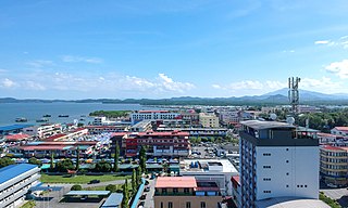
Kota Kinabalu, colloquially referred to as KK, is the state capital of Sabah, Malaysia. It is also the capital of the Kota Kinabalu District as well as the West Coast Division of Sabah. The city is located on the northwest coast of Borneo facing the South China Sea. The Tunku Abdul Rahman National Park lies to its west and Mount Kinabalu, which gave the city its name, is located to its east. Kota Kinabalu has a population of 452,058 according to the 2010 census; when the adjacent Penampang and Tuaran districts are included, the metro area has a combined population of 628,725. The 2020 Census revealed an increase in the municipal population to 500,421, while the wider area including the Penampang and Putatan districts had a population of 731,406.
Lahad Datu is the capital of the Lahad Datu District in the Dent Peninsula on Tawau Division of Sabah, Malaysia. Its population was estimated to be around 27,887 in 2010. The town is surrounded by stretches of cocoa and palm oil plantations. It is also an important timber exporting port. The town has an airport for domestic flights.

Sandakan formerly known at various times as Elopura, is the capital of the Sandakan District in Sabah, Malaysia. It is the second largest city in Sabah after Kota Kinabalu. It is located on the Sandakan Peninsula and east coast of the state in the administrative centre of Sandakan Division and was the former capital of British North Borneo. In 2010, the city had an estimated population of 157,330 while the overall municipal area had a total population of 396,290. The population of the municipal area had increased to 439,050 by the 2020 Census.

West Coast Division is an administrative division of Sabah, Malaysia. It occupies the northwest portion of Sabah. With an area of 7,588 square kilometres, it occupies 10.3% of Sabah's territory. It also has approximately 30% of Sabah's total population, with the main indigenous inhabitants comprising the Bajau, Bisaya, Bruneian Malay, Dusun, Illanun, Kadazan and Kedayan, as well with a significant numbers of Chinese. The division is divided into the districts of Ranau, Kota Belud, Tuaran, Penampang, Papar, and the state capital Kota Kinabalu. The main towns are as in the names of the districts, plus other towns including Putatan, Inanam, Telipok, Tamparuli, Tenghilan and Kinarut.

Kota Kinabalu International Airport (KKIA) is an international airport in Kota Kinabalu, the state capital of Sabah, Malaysia. It is located approximately 8 km (5.0 mi) southwest of the city centre. In 2019, over 9 million passengers passed through the airport, making it the second busiest airport in Malaysia after Kuala Lumpur International Airport in terms of passenger movements & aircraft movements and the third busiest in terms of cargo handled.

Inanam is a suburb and sub-district of Kota Kinabalu in Sabah, Malaysia. It is situated 10 kilometres from the city centre.

The Kota Kinabalu City Mosque is the second main mosque for the city of Kota Kinabalu in Likas, Kota Kinabalu, Sabah, Malaysia, after the State Mosque in Sembulan. The head imam is Ustaz Haji Hafiz Bin Datuk Dr Haji Hamzah.

Gaya Island is a sizeable Malaysian island of 1,465 ha, just 10 minutes off Kota Kinabalu, Sabah and forms part of the Tunku Abdul Rahman National Park. Gaya Island derived its name from the Bajau word "Gayo" which means big and occupies an area of 15 km2 with an elevation of up to 300 metres. Several ridges rise more than 600 feet, peaking at 1,000 feet, along the backbone of Gaya Island.

The Kota Kinabalu City Hall is the city council which administers the city and district of Kota Kinabalu in the state of Sabah, Malaysia. The council consists of the mayor plus twenty-four councillors appointed to serve a one-year term by the Sabah State Government.

Telipok is a town located approximately 15 kilometres north of Kota Kinabalu, the state capital of Sabah, Malaysia. The town is within the administration of Kota Kinabalu City Hall and is a sub-district of the city. It is also part of the urban expanse of Kota Kinabalu, and of its metropolitan area. It is situated near Kota Kinabalu Industrial Park, and is within 5 kilometres of the towns of Manggatal, Sepanggar, and Tuaran.

Datu Mustapha bin Datu Harun, or Tun Mustapha for short, was a Malaysian politician who served as the 3rd Chief Minister of Sabah from May 1967 to November 1975 and the 1st Yang Di-Pertua Negara from September 1963 to September 1965 and President of the United Sabah National Organisation (USNO). He is considered by some to be one of the founding leaders of Sabah and was an important party in the negotiations leading to the formation of Malaysia on 16 September 1963. He is sometimes known as the "Father of Independence of Sabah" and also the "Father of Development of Sabah".

Universiti Malaysia Sabah is a public university in Malaysia. It was officially established on 24 November 1994 as the ninth public university in the country. The university is located on a 999-acre site at Sepanggar Bay in Kota Kinabalu in the Malaysian state of Sabah. With Mount Kinabalu and the South China Sea as its background, UMS is often considered as among the most beautiful campuses in Southeast Asia.

Datuk Seri Panglima Haji Abdul Rahman bin Dahlan is a Malaysian politician. He is the former Minister in the Prime Minister's Department and the Minister of Urban Wellbeing, Housing and Local Government. He is also the former Member of Parliament (MP) of Malaysia for the Kota Belud constituency in Sabah, representing the United Malay National Organisation (UMNO) party, a component of Barisan Nasional (BN).

Manukan Island is the second largest island in the Tunku Abdul Rahman National Park, Malaysia's first marine national park. It is located in the East Malaysian state of Sabah, just off the coast of Kota Kinabalu and is easily accessible by boat.

Greater Kota Kinabalu refers to the dense clusters of regional populated areas surrounding the city of Kota Kinabalu in Malaysia. It comprises the districts of Kota Kinabalu, Penampang, Tuaran and Papar. These districts are also part of the West Coast Division. It was forecasted that in 2019, the combined population of these districts was 1.1 million people, in a combined area of 3,277 km2.

Sepanggar is a federal constituency in West Coast Division, Sabah, Malaysia, that has been represented in the Dewan Rakyat since 2004.

The Sabah Art Gallery is an art gallery in Kota Kinabalu, Sabah, Malaysia.

The Kota Belud District is an administrative district in the Malaysian state of Sabah, part of the West Coast Division which includes the districts of Kota Belud, Kota Kinabalu, Papar, Penampang, Putatan, Ranau and Tuaran. The capital of the district is in Kota Belud Town.


