
Sabah is a state of Malaysia located on the northern portion of Borneo, in the region of East Malaysia. Sabah has land borders with the Malaysian state of Sarawak to the southwest and Indonesia's North Kalimantan province to the south. The Federal Territory of Labuan is an island just off the Sabah coast. Sabah shares maritime borders with Vietnam to the west and the Philippines to the north and east. Kota Kinabalu is the state capital city, the economic centre of the state, and the seat of the Sabah state government. Other major towns in Sabah include Sandakan and Tawau. The 2020 census recorded a population of 3,418,785 in the state. Sabah has an equatorial climate with tropical rainforests and abundant animal and plant species. The state has long mountain ranges on the west side which forms part of the Crocker Range National Park. Kinabatangan River, the second longest river in Malaysia runs through Sabah, and Mount Kinabalu is the highest point of Sabah as well as of Malaysia.
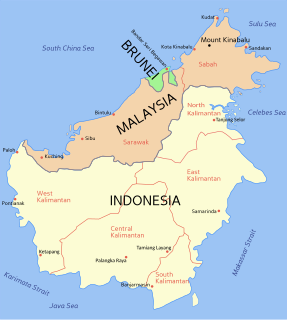
East Malaysia, also known as Sabah, Sarawak and Labuan or Malaysian Borneo, is the part of Malaysia on and near the island of Borneo, the world's third largest island. It consists of the Malaysian states of Sabah and Sarawak, as well as the Federal Territory of Labuan. Labuan is an island in a small archipelago near the coast of Sabah. East Malaysia lies to the east of Peninsular Malaysia, the part of the country on the Malay Peninsula. The two are separated by the South China Sea.

Kota Kinabalu, colloquially referred to as KK, is the state capital of Sabah, Malaysia. It is also the capital of the Kota Kinabalu District as well as the West Coast Division of Sabah. The city is located on the northwest coast of Borneo facing the South China Sea. The Tunku Abdul Rahman National Park lies to its west and Mount Kinabalu, which gave the city its name, is located to its east. Kota Kinabalu has a population of 452,058 according to the 2010 census; when the adjacent Penampang and Putatan districts are included, the metro area has a combined population of 628,725.

Kudat is the capital of the Kudat District in the Kudat Division of Sabah, Malaysia. Its population was estimated to be around 29,025 in 2010. It is located on the Kudat Peninsula, about 190 kilometres (120 mi) north of Kota Kinabalu, the state capital, and is near the northernmost point of Borneo. It is the largest town in the heartland of the Rungus people which is a sub-ethnic group of the majority Kadazan-Dusun race and is therefore a major centre of Rungus culture. It is also notable for being one of the first parts of Sabah to be settled by Chinese Malaysians, particularly from the Hakka dialect group. It is the Northernmost Malaysian city.
Lahad Datu is the capital of the Lahad Datu District in the Dent Peninsula on Tawau Division of Sabah, Malaysia. Its population was estimated to be around 27,887 in 2010. The town is surrounded by stretches of cocoa and palm oil plantations. It is also an important timber exporting port. The town has an airport for domestic flights.

Sandakan formerly known at various times as Elopura, is the capital of the Sandakan District in Sabah, Malaysia. It is the second largest city in Sabah after Kota Kinabalu. It is located on the Sandakan Peninsula and east coast of the state in the administrative centre of Sandakan Division and was the former capital of British North Borneo. In 2010, the city had an estimated population of 157,330 while the surrounding municipal area had a total population of 396,290. The population of the municipal area had increased to 510,600 by 2020.
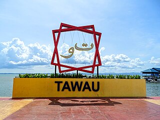
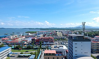
Tawau formerly known as Tawao, is the capital of the Tawau District in Sabah, Malaysia. It is the third-largest city in Sabah, after Kota Kinabalu and Sandakan. It is located on the Semporna Peninsula in the southeast coast of the state in the administrative centre of Tawau Division, which is bordered by the Sulu Sea to the east, the Celebes Sea to the south at Cowie Bay and shares a border with North Kalimantan, Indonesia. The town had an estimated population as of 2010, of 113,809, while the whole municipality area had a population of 397,673.

Kudat Division is an administrative division in the state of Sabah, Malaysia. It occupies the northern tip of Sabah. Its total area of 4,623 square kilometres makes it the smallest of the five divisions of Sabah. The division covers the districts of Kudat, Pitas and Kota Marudu, as well as the islands of Balak, Balambangan, Banggi, Bankawan, Guhuan Utara, Kalampunian and Malawali.
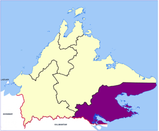
Tawau Division is one of the five administrative sub-divisions of Sabah, Malaysia. It occupies a total of 14,905 square kilometres or 20% of Sabah's territory. The main towns include the capital of Tawau, Lahad Datu, Kunak and Semporna. Tawau division has 26% of Sabah's total population, with the main indigenous groups consisting of the Bajau, Suluk, Ida'an, Tidong, Cocos, Murut, Lun Bawang/Lun Dayeh as well as a minority of mixed ethnic groups. Large numbers of both legal and illegal immigrants from Indonesia such as the Buginese and Torajans, from East Timor the Timorese, from the Philippines the Tausūg and Visayans as well South and West Asian immigrants such as Pakistanis, Indians and Arabs can be found in this area. As with the rest of Sabah, the division also has large numbers of ethnic Chinese.

Sandakan Division is an administrative division of Sabah, Malaysia. It stretches diagonally from the northeastern coast of Sabah to the state's central region. With an area of 28,205 square kilometres, it occupies 38.3% of Sabah's territory, and is thus the largest of the five administrative divisions of Sabah. It also has approximately 19.4% of Sabah's total population, with the major inhabitants comprising the Chinese, Orang Sungai, Kadazan-Dusun, Suluk and Bajau Simunul.

West Coast Division is an administrative division of Sabah, Malaysia. It occupies the northwest portion of Sabah. With an area of 7,588 square kilometres, it occupies 10.3% of Sabah's territory. It also has approximately 30% of Sabah's total population, with the main indigenous inhabitants comprising the Bajau, Bisaya, Bruneian Malay, Dusun, Illanun, Kadazan and Kedayan, as well with a significant numbers of Chinese. The division is divided into the districts of Ranau, Kota Belud, Tuaran, Penampang, Papar, and the state capital Kota Kinabalu. The main towns are as in the names of the districts, plus other towns including Putatan, Inanam, Telipok, Tamparuli, Tenghilan and Kinarut.

The Interior Division is an administrative division of the state of Sabah, Malaysia. It occupies the southwest portion of Sabah, bordered by the neighbouring state of Sarawak on its west. With an area of 18,298 square kilometres, it covers 24.9% of Sabah's territory and is home to approximately 14.7% of Sabah's total population. The largest town in the Interior Division is Keningau. Other main towns in this division include Beaufort, Kuala Penyu, Sipitang, Tambunan and Tenom.

Sipitang is the capital of the Sipitang District in the Interior Division of Sabah, Malaysia. Its population was estimated to be around 4,298 in 2010. It is the closest town in Sabah to the Sarawak border, and is 44 kilometres south of Beaufort and 144 kilometres south of Kota Kinabalu, the state capital and also is 123 kilometres north of Long Pasia, one of the famous attraction in Sabah.

Keningau is the capital of the Keningau District in the Interior Division of Sabah, Malaysia. It is the fifth-largest town in Sabah, as well one of the oldest. Keningau is between Tambunan and Tenom. The town had an estimated population of 173,130.

Beaufort is the capital of the Beaufort District in the Interior Division of Sabah, Malaysia. It was named after former British Governor Leicester Paul Beaufort. Its population was estimated to be around 12,742 in 2010. It is about 90 kilometres south of Kota Kinabalu and about 167 kilometres north of Long Pasia. It has shophouses built high above the roads to avoid the periodic floods of the Padas River. The population of Beaufort is composed mainly of Bisaya, Brunei Malays, Kadazan-Dusuns, Lun Bawang/Lun Dayeh, Muruts and Chinese. Bisaya are the majority ethnic, and the population is scattered around the town. Like other towns in Sabah such as Kota Kinabalu city, Tawau, Papar, Kudat and Tenom, Beaufort was one of the major initial Hakka population centres in Sabah and still has a large Hakka minority.
Federal Route 500 is a 163-kilometre (101 mi) federal highway in Sabah, Malaysia, connecting Kota Kinabalu to Tenom. It serves as the main highway from Kota Kinabalu to towns and villages in the Interior Division of Sabah. Federal Route 500 is one of the five highways in Sabah crossing the Crocker Range; the Tamparuli-Ranau Highway, Kimanis-Keningau Highway and Jalan Tenom-Sipitang are the other three and the new highway, Interior North–South Highway.
The 1985 Lahad Datu ambush was a series of robberies and random shootings that occurred on 23 September 1985 when 15–20 armed foreign pirates landed on the coast of Lahad Datu, Malaysia, and stormed the town. The pirates shot at random targets, killing at least 21 people and injuring 11 others, and stole some $200,000 from a local bank as well as another $5,000 from the Malaysia Airlines office.

The Sipitang District is an administrative district in the Malaysian state of Sabah, part of the Interior Division which also includes the districts of Beaufort, Keningau, Kuala Penyu, Nabawan, Tambunan and Tenom. The capital of the district is in Sipitang Town. The ecotourism village of Long Mio and Long Pasia is located in this district, while the small town of Sindumin serves as a gateway to the state of Sarawak.

The Penampang District is an administrative district in the Malaysian state of Sabah, part of the West Coast Division which includes the districts of Kota Belud, Kota Kinabalu, Papar, Penampang, Putatan, Ranau and Tuaran. The capital of the district is in Penampang Town.

Sandakan Heritage Museum is a museum located at the 1st floor of Wisma Warisan building in Sandakan of Sabah, Malaysia. The museum building is located next to the Sandakan Municipal Council and is part of the Sandakan Heritage Trail.

