Aberdeen , Scotland is a city located between the River Dee and the River Don.
Aberdeen , Scotland is a city located between the River Dee and the River Don.
Exposed Aberdeen is noted for its biting winds and driving rain, which sweep in from the North Sea, the mean temperature is 8 °C (46 °F) and it varies between an average low of 5 and 11 °C (41 and 52 °F). In summer (June - August) the average high is 16 °C (61 °F) and average low 9 °C (48 °F). In winter (December - February) the average high is 6 °C (43 °F) and average low 0 °C (32 °F).
The average yearly precipitation is 753 millimetres (29.6 in), with 64 millimetres (2.5 in) in summer (June - August) and 62 millimetres (2.4 in) in winter (December - February). The wettest months are October and November.
Education: Educationally Aberdeen has a higher student rate than the national average of 11.5% compared with 7% nationally. [1]
Household: In the household, there were 97,013 individual dwellings recorded in the city of which 61% were privately owned, 9% privately rented and 23% rented from the council. The most popular type of dwellings are apartments which have 49% of residences followed by semi-detached at just below 22%. [2]
Income The average income of a household in the city is £16,813 [3] (2005) which places about 18% households in the city below the poverty line (defined as 60% of the mean income).

Population: In 1396 the population was about 3,000. By 1801 it had become 26,992; in 1841 it was 63,262; (1891) 121,623; (1901) 153,503; (1941) 182,467. [4] In 2001 it UK census records the Aberdeen City Council areas population at 212,125, [5] but the Aberdeen locality's population at 184,788. [6] The latest official population estimate, published by the General Register for Scotland for 2005, is 202,370. [6]
The population density of Aberdeen is 2,819 persons per square mile (1,088 persons/km2). [7]
Data from the Aberdeen specific locality of the 2001 UK census shows that the demographics include a median male age of 35 and female age of 38 which are younger than Scotland's average and a 49% to 51% male to female ratio. [5]
It also showed that there are fewer young people in Aberdeen, with 16.4% under 16, opposed to the national average of 19.2%. [8] Ethnically, 15.7% were born outside Scotland, higher than the national average of 12.9%. Of this population 8.4% were born in England. [8] 3% of Aberdonians are considered to be from an ethnic minority (non-white), with 0.7% from the Indian-subcontinent and 0.6% Asian. [8]
Religion: The last census revealed that Aberdeen is the least religious city in Scotland, with nearly 43% of people claiming to have no religion. [8]
Aberdeen extends to 71.22 square miles (184.5 km2), and includes the former burghs of Old Aberdeen, New Aberdeen, Woodside and the Royal Burgh of Torry to the south of River Dee. The city is built on many hills, with the original beginnings of the city growing from Castle Hill, St. Catherine's Hill and Windmill Hill (also known as the Gallowgate). [9]
| Average (unless stated) / Month | Average | Jan | Feb | Mar | Apr | May | Jun | Jul | Aug | Sep | Oct | Nov | Dec |
|---|---|---|---|---|---|---|---|---|---|---|---|---|---|
| High temperature Celsius (°F) | 11 (52) | 5 (42) | 6 (43) | 7 (46) | 10 (50) | 12 (55) | 15 (60) | 17 (64) | 17 (64) | 15 (59) | 11 (53) | 8 (47) | 6 (44) |
| Low temperature Celsius (°F) | 5 (41) | 0 (32) | 0 (33) | 1 (35) | 2 (37) | 5 (42) | 8 (47) | 10 (51) | 10 (50) | 7 (46) | 5 (42) | 2 (37) | 1 (35) |
| Highest recorded temp. Celsius (°F) | Highest ever: 27 (82) | 17 (63) | 17 (63) | 20 (68) | 23 (74) | 24 (76) | 26 (79) | 27 (82) | 27 (82) | 24 (76) | 21 (70) | 16 (62) | 15 (60) |
| Lowest recorded temp. Celsius (°F) | Lowest ever: -18 (-2) | -18 (-2) | -15 (5) | -11 (12) | -3 (25) | -3 (26) | -0 (33) | 2 (37) | 0 (32) | -2 (28) | -3 (25) | -15 (5) | -13 (7) |
| Dew points Celsius (°F) | year: 5 (41) | 0.5 (33) | 0.5 (33) | 1.6 (35) | 2.8 (37) | 5.6 (42) | 8.3 (47) | 10.6 (51) | 10.6 (51) | 8.3 (47) | 6.1 (43) | 2.8 (37) | 1.6 (35) |
| Source: Washington Post Weather, Weatherbase (dew points) | |||||||||||||
| Average / Month | Average | Jan | Feb | Mar | Apr | May | Jun | Jul | Aug | Sep | Oct | Nov | Dec |
|---|---|---|---|---|---|---|---|---|---|---|---|---|---|
| Precipitation millimetres (in) | 62 (2.5) / year: 753 (29.7) | 63 (2.5) | 50 (2.0) | 53 (2.1) | 48 (1.9) | 53 (2.1) | 50 (2.0) | 71 (2.8) | 71 (2.8) | 63 (2.5) | 76 (3.0) | 78 (3.1) | 73 (2.9) |
| Number of rain days | 23.75 / year: 285 | 22 | 20 | 23 | 25 | 19 | 23 | 24 | 22 | 23 | 24 | 24 | 26 |
| Highest rec. rainfall millimetres (in) | ever: 269 (10.6) | 157 (6.2) | 129 (5.1) | 132 (5.2 | 155 (6.1) | 153 (6) | 122 (4.8) | 198 (7.8) | 178 (7) | 193 (7.6) | 198 (7.8) | 269 (10.6) | 244 (9.4) |
| Lowest rec. rainfall millimetres (in) | ever: | 5 (0.2) | 5 (0.2) | 5 (0.2) | 2.5 (0.1) | 5 (0.2) | 12 (0.5) | 12 (0.5) | 0 (0) | 15 (0.6) | 7.6 (0.3) | 10 (0.4) | 12 (0.5) |
| Sources: Washington Post Weather (precipitation), Interhome (rain days), Weatherbase (highest and lowest precipitation) | |||||||||||||
| Average (unless stated) / Month | Average | Jan | Feb | Mar | Apr | May | Jun | Jul | Aug | Sep | Oct | Nov | Dec |
|---|---|---|---|---|---|---|---|---|---|---|---|---|---|
| Sunshine hours | 114.4 / year: 1372.5 | 53 | 74.6 | 113.2 | 147.6 | 175.8 | 174.3 | 158.7 | 154.1 | 117.3 | 95.8 | 63.3 | 45 |
| Humidity morning / afternoon (%) | 87 / 75 / day: 85 | 85 / 81 | 86 / 77 | 86 / 72 | 87 / 70 | 88 / 71 | 87 / 72 | 88 / 72 | 90 / 72 | 88 / 73 | 88 / 78 | 86 / 80 | 85 / 82 |
| Wind miles per hour (km/h) | 12 (20) | 14 (24) | 12 (20) | 13 (22) | 11 (18) | 11 (18) | 11 (18) | 10 (16) | 10 (16) | 11 (18) | 12 (20) | 13 (22) | 12 (20) |
| Sealevel pressure millibars | 1011.4 | 1009.2 | 1011.1 | 1010.9 | 1012.6 | 1014.6 | 1014.7 | 1012.8 | 1011.9 | 1012.2 | 1010.3 | 1009.3 | 1007.7 |
| Station level pressure millibars | 1004.4 | 1000.2 | 1005.6 | 1002.0 | 1007.6 | 1006.4 | 1007.4 | 1006.8 | 1006.6 | 1004.5 | 1003.1 | 1002.0 | 1000.6 |
| Days with fog | year: 113 | 7 | 7 | 8 | 9 | 13 | 12 | 12 | 13 | 9 | 10 | 6 | 7 |
| Days with thunderstorms | year: 3 | 0 | 0 | 0 | 0 | 0 | 1 | 1 | 1 | 0 | 0 | 0 | 0 |
| Sources: Washington Post Weather (humidity and wind), Met Office (sunshine hours), World Climate (sea and station level pressures), Weatherbase (thunderstorms and fog) | |||||||||||||
| Year | 1396 | 1801 | 1841 | 1891 | 1901 | 1921 | 1941 | 1961 | 1981 | 2001 | 2005 (est) | ||
|---|---|---|---|---|---|---|---|---|---|---|---|---|---|
| Population | 3,000 | 26,992 | 63,262 | 121,623 | 153,503 | 171,709 | 182,467 | 205,969 | 199,770 | 212,125 | 202,370 [6] | ||
| Source: Vision of Britain | |||||||||||||
| Age range of population (years) | 0-4 | 5-15 | 16-29 | 30-44 | 45-59 | 60-74 | 75 and over | ||||||
|---|---|---|---|---|---|---|---|---|---|---|---|---|---|
| Percentage (Aberdeen / Scotland average) | 4.6 (5.47) | 11.16 (13.73) | 23.66 (17.46) | 22.48 (22.97) | 17.61 (19.29) | 13.20 (13.98) | 7.28 (7.09) | ||||||
| Source: Scotland's Census 2001 | |||||||||||||

Aberdeen is a city in North East Scotland, and is the third most populous city in the country. Aberdeen is one of Scotland's 32 local government council areas, and has a 2020 population estimate of 198,590 for the city of Aberdeen, and 227,560 for the local council area making it the United Kingdom's 39th most populous built-up area. The city is 93 mi (150 km) northeast of Edinburgh and 398 mi (641 km) north of London, and is the northernmost major city in the United Kingdom. Aberdeen has a long, sandy coastline and features an oceanic climate, with cool summers and mild, rainy winters.

Aberdeen is a city in and the county seat of Brown County, South Dakota, United States, located approximately 125 miles (201 km) northeast of Pierre. The city population was 28,495 at the 2020 census, making it the third most populous city in the state after Sioux Falls and Rapid City. Aberdeen is the principal city of the Aberdeen Micropolitan Statistical Area, which includes all of Brown and Edmunds counties and has a population of 42,287 in 2020. Aberdeen is considered a college town, being the home of both Northern State University and Presentation College.

Clay County is a county in the U.S. state of Illinois. As of the 2020 United States Census, the population was 13,288. Since 1842, its county seat has been Louisville, in the center of the county's area.

Perth is a city in central Scotland, on the banks of the River Tay. It is the administrative centre of Perth and Kinross council area and is the historic county town of Perthshire. It had a population of about 47,430 in 2018.

Alamosa is a home rule municipality and the county seat of Alamosa County, Colorado, United States. The city population was 9,806 in the 2020 United States Census. The city is the commercial center of the San Luis Valley in south-central Colorado, and is the home of Adams State University.

Martin County is a county in the U.S. state of Indiana. As of the 2020 United States Census, the population was 10,327. The county seat is Shoals at the center of the county, and the county's only incorporated city is Loogootee, on the county's western border.

Knox County is a county in the U.S. state of Indiana in the United States. The oldest county in Indiana, it was one of two original counties created in the Northwest Territory in 1790, alongside St. Clair County, Illinois. Knox County was gradually reduced in size as subsequent counties were established. It was established in its present configuration when Daviess County was partitioned off. At the 2020 United States Census, the county population was 36,282. The county seat is Vincennes.

Decatur County is a county in the U.S. state of Indiana. As of the 2020 United States Census, the population was 26,472. The county seat is Greensburg.

Wayne County is a county located in the U.S. state of Illinois. According to the 2020 census, it had a population of 16,179. Its county seat is Fairfield. It is located in the southern portion of Illinois known locally as "Little Egypt".
Shelby County is a county located in the U.S. state of Illinois. According to the 2020 census, it had a population of 20,990. Its county seat is Shelbyville.

Saline County is a county in Southern Illinois. At the 2020 census, it had a population of 23,768. The largest city and county seat is Harrisburg. This area of Southern Illinois is known locally as "Little Egypt".

Pulaski County is a county located in the U.S. state of Illinois. According to the 2020 census, it had a population of 5,193. Its county seat is Mound City. Its largest city is Mounds. It is located along the Ohio River in the southwestern portion of the state, known locally as "Little Egypt".

Aberdeen is a city in Bingham County, Idaho, United States. The community was named after Aberdeen, in Scotland. The population was 1,994 at the 2010 census, up from 1,840 in 2000.

Elkhart is a city in and the county seat of Morton County, Kansas, United States. As of the 2020 census, the population of the city was 1,888. The south edge of the city is the Kansas-Oklahoma state border, and the city is 8.5 miles (13.7 km) from the Kansas-Colorado border.

Moro is a city in Sherman County, Oregon, United States. The population was 324 at the 2010 census. It is the county seat of Sherman County It’s currently the least-populous county seat in Oregon. Moro was incorporated on February 17, 1899, by the Oregon Legislative Assembly. It was named for Moro, Illinois.
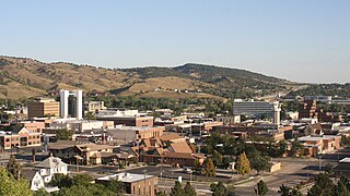
Rapid City is the second most populous city in South Dakota after Sioux Falls and the county seat of Pennington County. Named after Rapid Creek, where the settlement developed, it is in western South Dakota, on the Black Hills' eastern slope. The population was 74,703 as of the 2020 Census.
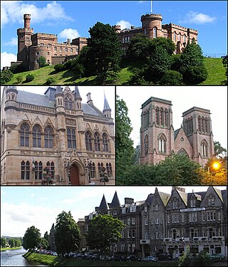
Inverness is a city in the Scottish Highlands, having been granted city status in 2000. It is the administrative centre for The Highland Council and is regarded as the capital of the Highlands. Historically it served as the county town of the county of Inverness-shire. Inverness lies near two important battle sites: the 11th-century battle of Blàr nam Fèinne against Norway which took place on the Aird, and the 18th century Battle of Culloden which took place on Culloden Moor. It is the northernmost city in the United Kingdom and lies within the Great Glen at its northeastern extremity where the River Ness enters the Beauly Firth. At the latest, a settlement was established by the 6th century with the first royal charter being granted by Dabíd mac Maíl Choluim in the 12th century. Inverness and Inverness-shire are closely linked to various influential clans, including Clan Mackintosh, Clan Fraser and Clan MacKenzie.
Cupar is a town, former royal burgh and parish in Fife, Scotland. It lies between Dundee and Glenrothes. According to a 2011 population estimate, Cupar had a population around 9,000, making it the ninth-largest settlement in Fife, and the civil parish a population of 11,183. It is the historic county town of Fife, although the council now sits at Glenrothes.
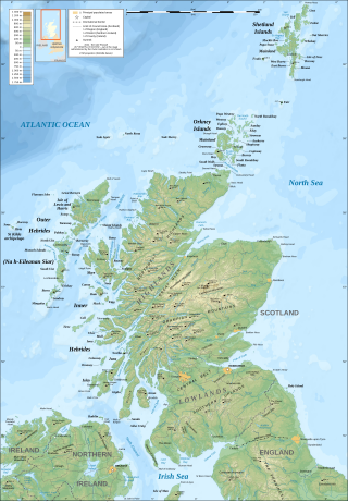
The geography of Scotland is varied, from rural lowlands to unspoilt uplands, and from large cities to sparsely inhabited islands. Located in Northern Europe, Scotland comprises the northern third of the island of Great Britain as well as 790 surrounding islands encompassing the major archipelagos of the Shetland Islands, Orkney Islands and the Inner and Outer Hebrides. The only land border is with England, which runs for 96 miles in a northeasterly direction from the Solway Firth in the west to the North Sea on the east coast. Separated by the North Channel, the island of Ireland lies 13 nautical miles from Mull of Kintyre on the Scottish mainland. Norway is located 190 nmi (350 km) northeast of Scotland across the North Sea. The Atlantic Ocean, which fringes the coastline of western and northern Scotland and its islands, influences the temperate, maritime climate of the country.

Viluppuram, Villupuram, or Vizhuppuram is a Municipality and the administrative headquarters of Viluppuram district.