Geography of the Faroe Islands

Last updated
Satellite image of the Faroe Islands Faroe Islands by Sentinel-2.jpg
Satellite image of the Faroe Islands

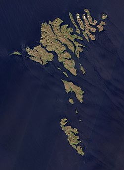
The Faroe Islands are an island group consisting of eighteen islands between the Norwegian Sea and the North Atlantic, about half-way between Iceland and Norway. Its coordinates are 62°N7°W / 62°N 7°W / 62; -7 . It is 1,393 square kilometres in area, and includes small lakes and rivers, but no major ones. There are 1,117 kilometres of coastline, and no land boundaries with any other country.

Contents

The Faroe Islands generally have cool summers and cool to cold winters, with a usually overcast sky and frequent fog and strong winds. Although at a high latitude, due to the Gulf Stream their climate is ameliorated. The islands are rugged and rocky with some low peaks; the coasts are mostly bordered by cliffs. The Faroe Islands are notable for having the highest sea cliffs in Europe, and some of the highest in the world otherwise. The lowest point is at sea level, and the highest is at Slættaratindur, which is 882 metres above sea level. The landscape made roadbuilding difficult, and only recently has this been remedied by building tunnels.

View of the west coast of Suduroy Beinisvord, westcoast of suduroy, faroe islands.JPG
View of the west coast of Suðuroy
Detailed map of the Faroe Islands FaroeIslands2022OSM.png
Detailed map of the Faroe Islands

Many of the Faroese islands tend to be elongated in shape. Natural resources include fish and hydropower.

Statistics

Map including the Faroe Islands Operational Navigation Chart D-1, 10th edition.jpg
Map including the Faroe Islands
Geographic coordinates
Area
  • Land: 1,393 km² [1]
  • Water: 7.19 km² (the area includes 10 of the largest lakes. There are a number of smaller lakes and streams.) [2]
Land boundaries
0 km
Coastline
1,117 km
Maritime claims
  • Territorial sea: 3 nmi (5.6 km; 3.5 mi)
  • Continental shelf: 200  nmi (370.4 km; 230.2 mi) or agreed boundaries or median line
  • Exclusive economic zone: 200 nmi (370.4 km; 230.2 mi) or agreed boundaries or median line
Climate
Subarctic oceanic climate (Köppen climate classification Cfc) moderated by North Atlantic Current; long, mild, windy winters; short, cool summers, damp in the South and West. Arctic climate (Köppen ET) in some mountains.
Terrain
Rugged, rocky, some low peaks; cliffs along most of coast. The coasts are deeply indented with fjords, and the narrow passages between islands are agitated by strong tidal currents. Multiple sea stacks exist along the coast.
Elevation extremes
Natural resources
Fish, whales, hydropower, wind, possible petroleum and natural gas
Land use
  • Arable land: 2.14%
  • Permanent crops: 0%
  • Other: 97.86% (2012)
Environment—international agreements
Marine dumping

Climate

The climate is classed as subpolar oceanic climate (Köppen climate classification Cfc ), with areas having a tundra climate, especially in the mountains, although some coastal or low-lying areas may have very mild-winter versions of a tundra climate. The overall character of the climate of the islands is influenced by the strong warming influence of the Atlantic Ocean, which produces the North Atlantic Current. This, together with the remoteness of any source of landmass-induced warm or cold airflows, ensures that winters are mild (mean temperature 3.0 to 4.0 °C or 37 to 39 °F) while summers are cool (mean temperature 9.5 to 10.5 °C or 49 to 51 °F).

The islands are windy, cloudy and cool throughout the year with an average of 210 rainy or snowy days per year. The islands lie in the path of depressions moving northeast, making strong winds and heavy rain possible at all times of the year. Sunny days are rare and overcast days are common. Hurricane Faith struck the Faroe Islands on 5 September 1966 with sustained winds over 100 mph (160 km/h) and only then did the storm cease to be a tropical system. [3]

An October evening on Eysturoy Faroe Islands, Eysturoy, Funningsfjordur (fjord) in October.jpg
An October evening on Eysturoy

Due to the altitude, ocean currents, topography, and winds, the islands exhibit a variety of microclimates. Precipitation varies considerably throughout the archipelago. In some highland areas, snow cover may last for months with snowfalls possible for the greater part of the year (on the highest peaks, summer snowfall is by no means rare), while in some sheltered coastal locations, several years pass without any snowfall whatsoever.

Climate data for Tórshavn (1991–2020, extremes 1961–2021)
MonthJanFebMarAprMayJunJulAugSepOctNovDecYear
Record high °C (°F)11.6
(52.9)
13.0
(55.4)
12.3
(54.1)
18.3
(64.9)
19.7
(67.5)
20.0
(68.0)
20.2
(68.4)
22.0
(71.6)
19.5
(67.1)
16.3
(61.3)
14.7
(58.5)
13.2
(55.8)
22.0
(71.6)
Average high °C (°F)6.2
(43.2)
6.0
(42.8)
6.4
(43.5)
7.6
(45.7)
9.3
(48.7)
11.3
(52.3)
12.9
(55.2)
13.3
(55.9)
11.9
(53.4)
9.6
(49.3)
7.6
(45.7)
6.5
(43.7)
9.0
(48.2)
Daily mean °C (°F)4.3
(39.7)
4.0
(39.2)
4.3
(39.7)
5.4
(41.7)
7.1
(44.8)
9.1
(48.4)
10.7
(51.3)
11.1
(52.0)
10.0
(50.0)
7.8
(46.0)
5.8
(42.4)
4.5
(40.1)
7.0
(44.6)
Average low °C (°F)2.1
(35.8)
1.6
(34.9)
2.1
(35.8)
3.2
(37.8)
5.0
(41.0)
7.3
(45.1)
9.1
(48.4)
9.3
(48.7)
8.1
(46.6)
5.7
(42.3)
3.6
(38.5)
2.2
(36.0)
4.9
(40.8)
Record low °C (°F)−8.8
(16.2)
−11.0
(12.2)
−9.2
(15.4)
−9.9
(14.2)
−3.0
(26.6)
0.0
(32.0)
1.5
(34.7)
1.5
(34.7)
−0.6
(30.9)
−4.5
(23.9)
−7.2
(19.0)
−10.5
(13.1)
−11.0
(12.2)
Average precipitation mm (inches)164.5
(6.48)
128.1
(5.04)
127.8
(5.03)
91.2
(3.59)
68.4
(2.69)
62.3
(2.45)
70.1
(2.76)
91.8
(3.61)
116.3
(4.58)
145.0
(5.71)
151.8
(5.98)
154.4
(6.08)
1,359.5
(53.52)
Average precipitation days (≥ 0.1 mm)262326221918192023262627273
Average snowy days8.36.68.04.41.50.00.00.00.11.45.58.244.0
Average relative humidity (%)89888887878889908989888988
Mean monthly sunshine hours 14.536.772.8108.6137.8128.6103.6100.982.753.421.17.8868.2
Source: Danish Meteorological Institute (humidity 1961–1990, precipitation days 1961–1990, snowy days 1961–1990), [4] [5] infoclimat.fr [6] (record high)

Tórshavn receives frosts more often than other areas just a short distance to the south. Snow is also seen at a much higher frequency than outlying islands nearby. The area receives on average 49 frosts a year. [7]

Climate data for Mykines, 105 m.a.s.l.
MonthJanFebMarAprMayJunJulAugSepOctNovDecYear
Record high °C (°F)9.0
(48.2)
9.5
(49.1)
10.0
(50.0)
12.5
(54.5)
13.0
(55.4)
15.0
(59.0)
16.0
(60.8)
16.0
(60.8)
14.0
(57.2)
11.5
(52.7)
10.6
(51.1)
9.5
(49.1)
16.0
(60.8)
Average high °C (°F)5.1
(41.2)
5.1
(41.2)
5.2
(41.4)
6.6
(43.9)
8.0
(46.4)
10.2
(50.4)
10.9
(51.6)
11.3
(52.3)
10.2
(50.4)
8.8
(47.8)
6.0
(42.8)
4.9
(40.8)
7.7
(45.9)
Daily mean °C (°F)3.5
(38.3)
3.5
(38.3)
3.5
(38.3)
4.8
(40.6)
6.2
(43.2)
8.5
(47.3)
9.2
(48.6)
9.6
(49.3)
8.7
(47.7)
7.4
(45.3)
4.6
(40.3)
3.3
(37.9)
6.1
(43.0)
Average low °C (°F)1.7
(35.1)
1.5
(34.7)
1.5
(34.7)
3.0
(37.4)
4.7
(40.5)
7.1
(44.8)
7.8
(46.0)
8.2
(46.8)
7.3
(45.1)
5.7
(42.3)
2.7
(36.9)
1.5
(34.7)
4.4
(39.9)
Record low °C (°F)−7.0
(19.4)
−11.0
(12.2)
−8.0
(17.6)
−10.0
(14.0)
−2.6
(27.3)
1.0
(33.8)
4.1
(39.4)
4.2
(39.6)
0.4
(32.7)
−5.0
(23.0)
−7.0
(19.4)
−7.0
(19.4)
−11.0
(12.2)
Average precipitation mm (inches)77
(3.0)
56
(2.2)
88
(3.5)
53
(2.1)
31
(1.2)
49
(1.9)
47
(1.9)
61
(2.4)
96
(3.8)
95
(3.7)
80
(3.1)
90
(3.5)
823
(32.4)
Average precipitation days (≥ 1.0 mm)171218139.212121115181619171
Average relative humidity (%)82818383848786878584818084
Source: Danish Meteorological Institute [8] [ page needed ]

While receiving more frost than most of the Faroe Islands, Mykines is more temperate in the winter than nearby Vágar. Snow is also less common despite the relatively lower winter temperatures due to the relatively low precipitation in the area. It also has a very mild tundra climate bordering on subpolar oceanic. Frost occurs on 46 days in an average year [8] It is also likely that the lower areas of the island experience less than this, as the weather station is located at 105 meters above sea level. [8]

Climate data for Akraberg, Suðuroy, 101 m.a.s.l.
MonthJanFebMarAprMayJunJulAugSepOctNovDecYear
Record high °C (°F)9.6
(49.3)
8.8
(47.8)
9.2
(48.6)
13.0
(55.4)
15.2
(59.4)
17.2
(63.0)
17.6
(63.7)
18.4
(65.1)
17.2
(63.0)
11.8
(53.2)
10.8
(51.4)
9.8
(49.6)
18.4
(65.1)
Average high °C (°F)5.4
(41.7)
5.4
(41.7)
5.5
(41.9)
6.5
(43.7)
8.1
(46.6)
9.9
(49.8)
11.1
(52.0)
11.4
(52.5)
10.2
(50.4)
8.8
(47.8)
6.6
(43.9)
5.8
(42.4)
7.9
(46.2)
Daily mean °C (°F)3.8
(38.8)
3.9
(39.0)
4.0
(39.2)
4.8
(40.6)
6.6
(43.9)
8.4
(47.1)
9.6
(49.3)
10.0
(50.0)
8.9
(48.0)
7.5
(45.5)
5.1
(41.2)
4.2
(39.6)
6.4
(43.5)
Average low °C (°F)1.9
(35.4)
2.0
(35.6)
2.0
(35.6)
2.9
(37.2)
5.0
(41.0)
6.9
(44.4)
8.1
(46.6)
8.5
(47.3)
7.2
(45.0)
5.8
(42.4)
3.2
(37.8)
2.2
(36.0)
4.6
(40.3)
Record low °C (°F)−7.2
(19.0)
−10.6
(12.9)
−7.0
(19.4)
−9.3
(15.3)
−4.0
(24.8)
0.0
(32.0)
2.0
(35.6)
3.0
(37.4)
0.0
(32.0)
−2.6
(27.3)
−5.6
(21.9)
−8.4
(16.9)
−10.6
(12.9)
Average precipitation mm (inches)90
(3.5)
60
(2.4)
77
(3.0)
48
(1.9)
43
(1.7)
51
(2.0)
65
(2.6)
65
(2.6)
94
(3.7)
108
(4.3)
90
(3.5)
95
(3.7)
884
(34.8)
Average precipitation days (≥ 1.0 mm)181317121011121216181719173
Average relative humidity (%)85858585888991918987848487
Source: Danish Meteorological Institute [9]

Akraberg is milder than much of the Faroe Islands and experiences frost on 38 days in an average year, [9] possibly less in lower areas, as the weather station is located at an elevation of 101 meters above sea level. [9]

Climate data for Vágar Airport, Vágar, 84 m.a.s.l.
MonthJanFebMarAprMayJunJulAugSepOctNovDecYear
Record high °C (°F)10.3
(50.5)
9.5
(49.1)
12.5
(54.5)
14.8
(58.6)
20.8
(69.4)
21.6
(70.9)
24.0
(75.2)
23.5
(74.3)
20.5
(68.9)
14.0
(57.2)
12.0
(53.6)
12.2
(54.0)
24.0
(75.2)
Average high °C (°F)4.8
(40.6)
4.8
(40.6)
5.2
(41.4)
6.4
(43.5)
8.8
(47.8)
10.8
(51.4)
12.1
(53.8)
12.3
(54.1)
10.4
(50.7)
8.6
(47.5)
6.1
(43.0)
5.3
(41.5)
8.0
(46.4)
Daily mean °C (°F)2.7
(36.9)
2.7
(36.9)
3.1
(37.6)
4.3
(39.7)
6.6
(43.9)
8.7
(47.7)
10.2
(50.4)
10.4
(50.7)
8.6
(47.5)
6.8
(44.2)
4.2
(39.6)
3.3
(37.9)
6.0
(42.8)
Average low °C (°F)0.5
(32.9)
0.6
(33.1)
0.9
(33.6)
2.1
(35.8)
4.4
(39.9)
6.6
(43.9)
8.3
(46.9)
8.5
(47.3)
6.7
(44.1)
4.8
(40.6)
2.1
(35.8)
1.1
(34.0)
3.9
(39.0)
Record low °C (°F)−10.0
(14.0)
−11.7
(10.9)
−10.6
(12.9)
−9.9
(14.2)
−5.0
(23.0)
−0.3
(31.5)
1.4
(34.5)
1.0
(33.8)
−2.5
(27.5)
−6.4
(20.5)
−10.0
(14.0)
−10.9
(12.4)
−11.7
(10.9)
Average precipitation mm (inches)163
(6.4)
122
(4.8)
141
(5.6)
120
(4.7)
83
(3.3)
81
(3.2)
115
(4.5)
133
(5.2)
151
(5.9)
164
(6.5)
140
(5.5)
142
(5.6)
1,555
(61.2)
Average precipitation days (≥ 1.0 mm)231921181311151819201820215
Source: Danish Meteorological Institute [8] [ page needed ]

Vágar has colder and snowier winters than most other places in the archipelago. Lower temperatures combined with higher precipitation are responsible for this, and measurable snow cover can be seen- a rarity in the Faroe Islands, in which snow cover (in areas which regularly experience it) is usually limited to a thin coating. The airport, at which data is recorded, is also located at a higher altitude on the island (84 meters above sea level [8] ), which might result in lower temperatures and higher precipitation than lower-lying areas on the island. Frost occurs on average on 62 days of the year, [8] the most out of all stations included in the records of the Danish Meteorological Institute.

Climate data for Kirkja, Fugloy, 53 m.a.s.l.
MonthJanFebMarAprMayJunJulAugSepOctNovDecYear
Record high °C (°F)13.4
(56.1)
12.0
(53.6)
13.0
(55.4)
14.9
(58.8)
19.8
(67.6)
20.0
(68.0)
21.3
(70.3)
20.8
(69.4)
20.6
(69.1)
18.8
(65.8)
13.0
(55.4)
14.5
(58.1)
21.3
(70.3)
Average high °C (°F)6.7
(44.1)
5.8
(42.4)
6.5
(43.7)
7.2
(45.0)
9.2
(48.6)
11.2
(52.2)
12.8
(55.0)
13.4
(56.1)
11.8
(53.2)
9.5
(49.1)
7.5
(45.5)
6.6
(43.9)
9.0
(48.2)
Daily mean °C (°F)4.6
(40.3)
3.7
(38.7)
4.3
(39.7)
5.2
(41.4)
7.0
(44.6)
9.0
(48.2)
10.6
(51.1)
11.2
(52.2)
9.7
(49.5)
7.5
(45.5)
5.8
(42.4)
4.4
(39.9)
6.9
(44.4)
Average low °C (°F)2.4
(36.3)
1.5
(34.7)
1.8
(35.2)
2.9
(37.2)
4.9
(40.8)
7.0
(44.6)
8.8
(47.8)
9.3
(48.7)
7.7
(45.9)
5.5
(41.9)
3.8
(38.8)
2.2
(36.0)
4.8
(40.6)
Record low °C (°F)−6.2
(20.8)
−5.5
(22.1)
−9.1
(15.6)
−4.2
(24.4)
−2.4
(27.7)
1.5
(34.7)
4.1
(39.4)
4.9
(40.8)
0.9
(33.6)
−2.0
(28.4)
−3.2
(26.2)
−6.2
(20.8)
−9.1
(15.6)
Average precipitation mm (inches)94
(3.7)
87
(3.4)
94
(3.7)
84
(3.3)
67
(2.6)
66
(2.6)
80
(3.1)
83
(3.3)
85
(3.3)
111
(4.4)
97
(3.8)
93
(3.7)
1,040
(40.9)
Average precipitation days (≥ 1.0 mm)18171812139.89.71315171815175
Source: Danish Meteorological Institute [8] [ page needed ]

Kirkja has a very mild climate, similar to Akraberg. It has the lowest frequency of frosts out of all weather stations included in the records by the Danish Meteorological Institute, with 36 days of frost in an average year. [8] Snowfall is uncommon, due to mild temperatures and relatively low precipitation. The weather station is somewhat high at 53 meters above sea level, [8] which could possibly affect the data, but not as much as the previous stations.

Climate data for Nólsoy, 80 m.a.s.l.
MonthJanFebMarAprMayJunJulAugSepOctNovDecYear
Record high °C (°F)12.1
(53.8)
10.6
(51.1)
10.8
(51.4)
13.3
(55.9)
18.2
(64.8)
18.6
(65.5)
18.0
(64.4)
17.8
(64.0)
17.2
(63.0)
14.0
(57.2)
12.2
(54.0)
11.5
(52.7)
18.6
(65.5)
Average high °C (°F)5.2
(41.4)
5.5
(41.9)
5.8
(42.4)
6.8
(44.2)
8.8
(47.8)
10.6
(51.1)
11.9
(53.4)
12.2
(54.0)
10.6
(51.1)
8.9
(48.0)
6.8
(44.2)
5.9
(42.6)
8.2
(46.8)
Daily mean °C (°F)3.5
(38.3)
3.8
(38.8)
3.9
(39.0)
4.7
(40.5)
6.7
(44.1)
8.5
(47.3)
9.9
(49.8)
10.2
(50.4)
8.8
(47.8)
7.3
(45.1)
5.0
(41.0)
4.0
(39.2)
6.3
(43.3)
Average low °C (°F)1.2
(34.2)
1.6
(34.9)
1.6
(34.9)
2.5
(36.5)
4.8
(40.6)
6.6
(43.9)
8.2
(46.8)
8.4
(47.1)
6.8
(44.2)
5.2
(41.4)
2.8
(37.0)
1.6
(34.9)
4.3
(39.7)
Record low °C (°F)−7.6
(18.3)
−6.8
(19.8)
−8.4
(16.9)
−6.6
(20.1)
−2.6
(27.3)
0.4
(32.7)
2.7
(36.9)
2.4
(36.3)
1.0
(33.8)
−4.0
(24.8)
−7.2
(19.0)
−9.2
(15.4)
−9.2
(15.4)
Average precipitation mm (inches)99
(3.9)
72
(2.8)
92
(3.6)
59
(2.3)
56
(2.2)
54
(2.1)
60
(2.4)
66
(2.6)
107
(4.2)
126
(5.0)
107
(4.2)
109
(4.3)
1,006
(39.6)
Average precipitation days (≥ 1.0 mm)191518131211121318201920189
Source: Danish Meteorological Institute [8] [ page needed ]

Nólsoy experiences a climate that is quite typical of the surrounding area and the Faroe Islands in general, and is similar to nearby Tórshavn. There are on average 44 days of frost a year. [8] Also, as in the case of previous weather stations, the location is higher on its respective island, and the climate of the lower areas of the island differs slightly.

Climate data for Sandur, Sandoy, 5 m.a.s.l.
MonthJanFebMarAprMayJunJulAugSepOctNovDecYear
Record high °C (°F)11.1
(52.0)
13.2
(55.8)
12.2
(54.0)
13.2
(55.8)
18.9
(66.0)
19.0
(66.2)
21.4
(70.5)
19.8
(67.6)
15.4
(59.7)
14.8
(58.6)
12.4
(54.3)
12.4
(54.3)
21.4
(70.5)
Average high °C (°F)5.7
(42.3)
5.9
(42.6)
6.3
(43.3)
7.5
(45.5)
9.8
(49.6)
11.8
(53.2)
13.0
(55.4)
13.2
(55.8)
11.3
(52.3)
9.5
(49.1)
7.1
(44.8)
6.1
(43.0)
8.9
(48.0)
Daily mean °C (°F)3.9
(39.0)
4.1
(39.4)
4.3
(39.7)
5.5
(41.9)
7.7
(45.9)
9.6
(49.3)
11.0
(51.8)
11.2
(52.2)
9.5
(49.1)
7.8
(46.0)
5.4
(41.7)
4.2
(39.6)
7.0
(44.6)
Average low °C (°F)1.6
(34.9)
1.9
(35.4)
2.1
(35.8)
3.2
(37.8)
5.4
(41.7)
7.5
(45.5)
9.1
(48.4)
9.4
(48.9)
7.5
(45.5)
5.8
(42.4)
3.2
(37.8)
1.9
(35.4)
4.9
(40.8)
Record low °C (°F)−7.8
(18.0)
−6.0
(21.2)
−7.9
(17.8)
−5.1
(22.8)
−2.4
(27.7)
0.7
(33.3)
4.4
(39.9)
3.1
(37.6)
0.8
(33.4)
−2.3
(27.9)
−6.1
(21.0)
−9.3
(15.3)
−9.3
(15.3)
Average precipitation mm (inches)133
(5.2)
89
(3.5)
110
(4.3)
69
(2.7)
64
(2.5)
58
(2.3)
71
(2.8)
78
(3.1)
118
(4.6)
146
(5.7)
125
(4.9)
131
(5.2)
1,193
(47.0)
Average precipitation days (≥ 1.0 mm)191518131111121116191719179
Source: Danish Meteorological Institute [8] [ page needed ]

The climate of Sandur is typical for a low-lying coastal location in the south of the Faroe Islands, as the weather station for Sandur is located at 5 meters above sea level. [8] On average, Sandur experiences 41 days of frost a year. [8]

See also

Further reading

Related Research Articles

<span class="mw-page-title-main">Geography of Greenland</span> Geography of the worlds largest island

Greenland is located between the Arctic Ocean and the North Atlantic Ocean, northeast of Canada and northwest of Iceland. The territory comprises the island of Greenland—the largest island in the world—and more than a hundred other smaller islands. Greenland has a 1.2 kilometre long border with Canada on Hans Island. A sparse population is confined to small settlements along certain sectors of the coast. Greenland possesses the world's second-largest ice sheet.

<span class="mw-page-title-main">Mediterranean climate</span> Type of climate

A Mediterranean climate, also called a dry summer climate, described by Köppen as Cs, is a temperate climate type that occurs in the lower mid-latitudes. Such climates typically have dry summers and wet winters, with summer conditions ranging from warm to hot and winter conditions typically being mild to cool. These weather conditions are typically experienced in the majority of Mediterranean-climate regions and countries, but remain highly dependent on proximity to the ocean, altitude and geographical location.

<span class="mw-page-title-main">Oceanic climate</span> Climate classification

An oceanic climate, also known as a marine climate, is the temperate climate sub-type in Köppen classification represented as Cfb, typical of west coasts in higher middle latitudes of continents, generally featuring cool summers and mild winters, with a relatively narrow annual temperature range and few extremes of temperature. Oceanic climates can be found in both hemispheres generally between 45 and 63 latitude, most notably in northwestern Europe, northwestern America, as well as New Zealand. Other varieties of climates usually classified together with these include subtropical highland climates, represented as Cwb or Cfb, and subpolar oceanic or cold subtropical highland climates, represented as Cfc or Cwc. Subtropical highland climates occur in some mountainous parts of the subtropics or tropics, some of which have monsoon influence, while their cold variants and subpolar oceanic climates occur near polar or tundra regions.

<span class="mw-page-title-main">Orcadas Base</span> Antarctic base

Base Orcadas is an Argentine scientific station in Antarctica, and the oldest of the stations in Antarctica still in operation. It is located on Laurie Island, one of the South Orkney Islands, at 4 meters (13 ft) above sea level and 170 meters (558 ft) from the coastline. Established by the Scottish National Antarctic Expedition in 1903 and transferred to the Argentine government in 1904, the base has been permanently populated since, being one of six Argentine permanent bases in Argentina's claim to Antarctica, and the first permanently inhabited base in Antarctica.

<span class="mw-page-title-main">Sørvágur</span> Village in Faroe Islands, Kingdom of Denmark

Sørvágur is a village on the island of Vágar in the Faroe Islands.

The city of Vancouver, located in British Columbia, Canada, has a moderate oceanic climate that borders on a warm-summer Mediterranean climate (Csb). Its summer months are typically dry, often resulting in moderate drought conditions, usually in July and August. In contrast, the rest of the year is rainy, especially between October and March.

<span class="mw-page-title-main">Climate of Romania</span>

The climate of Romania is continental, transitioning into humid subtropical on the eastern coast, influenced by polar intrusions, and therefore characterized by harsh winters. The mountain ranges of the Carpathian arc have a cool mountain climate with high humidity throughout the year.

<span class="mw-page-title-main">Climate of the Arctic</span>

The climate of the Arctic is characterized by long, cold winters and short, cool summers. There is a large amount of variability in climate across the Arctic, but all regions experience extremes of solar radiation in both summer and winter. Some parts of the Arctic are covered by ice year-round, and nearly all parts of the Arctic experience long periods with some form of ice on the surface.

<span class="mw-page-title-main">Climate of North Carolina</span> Overview of the climate of the U.S. state of North Carolina

North Carolina's climate varies from the Atlantic coast in the east to the Appalachian Mountain range in the west. The mountains often act as a "shield", blocking low temperatures and storms from the Midwest from entering the Piedmont of North Carolina.

<span class="mw-page-title-main">Climate of Japan</span> Overview of the Climate of Japan

Most regions of Japan, such as Honshu, Shikoku, and Kyushu, belong to the temperate zone with humid subtropical climate characterized by four distinct seasons. However, its climate varies from cool humid continental climate in the north such as northern Hokkaido, to warm tropical rainforest climate in the south such as the Yaeyama Islands and Minami-Tori-shima.

<span class="mw-page-title-main">Climate of Ireland</span> Climate of Ireland

The climate of Ireland is mild, humid and changeable with abundant rainfall and a lack of temperature extremes. Ireland's climate is defined as a temperate oceanic climate, or Cfb on the Köppen climate classification system, a classification it shares with most of northwest Europe. The island receives generally warm summers and cool winters.

<span class="mw-page-title-main">Climate of New York (state)</span> Overview of the climate of the U.S. state of New York

The climate of New York (state) is generally humid continental, while the extreme southeastern portion of the state lies in the warmer humid subtropical climate zone. Winter temperatures average below freezing during January and February in much of the state of New York, but several degrees above freezing along the Atlantic coastline, including New York City.

<span class="mw-page-title-main">Climate of Tasmania</span>

Tasmania has a cool temperate climate with four distinct seasons. The highest recorded maximum temperature in Tasmania is 42.2 °C (108.0 °F) at Scamander on 30 January 2009, during the 2009 southeastern Australia heat wave. Tasmania's lowest recorded minimum temperature is −14.2 °C (6.4 °F) on 7 August 2020, at Central Plateau.

<span class="mw-page-title-main">Climate of Greenland</span> Overview of the Climate of Greenland

Greenland's climate is a tundra climate on and near the coasts and an ice cap climate in inland areas. It typically has short, cool summers and long, moderately cold winters.

<span class="mw-page-title-main">Climate of Kosovo</span>

Kosovo is a relatively small country. Because of the climatic position and complicated structure of the relief it has a variety of climate systems.

<span class="mw-page-title-main">Humid subtropical climate</span> Transitional climatic zone

A humid subtropical climate is a temperate climate type characterized by hot and humid summers, and cool to mild winters. These climates normally lie on the southeast side of all continents, generally between latitudes 25° and 40° and are located poleward from adjacent tropical climates. It is also known as warm temperate climate in some climate classifications.

<span class="mw-page-title-main">Climate of Barcelona</span> Climate of Barcelona, Spain

Barcelona has a maritime Mediterranean climate Csa according to Köppen-Geiger classification, a warm-temperate subtropical climate according to Troll-Paffen climate classification, and a subtropical climate according to Siegmund/Frankenberg climate classification.

<span class="mw-page-title-main">Climate of New England</span> Overview of the climate of New England

The climate of New England varies greatly across its 500-mile (800 km) span from northern Maine to southern Connecticut.

<span class="mw-page-title-main">Climate of Seattle</span> Overview of climatic conditions in Seattle

The climate of Seattle is temperate, classified in the warm-summer (in contrast to hot-summer) subtype of the Mediterranean zone by the most common climate classification although some sources put the city in the oceanic zone. It has cool, wet winters and mild, relatively dry summers, covering characteristics of both. The climate is sometimes characterized as a "modified Mediterranean" climate because it is cooler and wetter than a "true" Mediterranean climate, but shares the characteristic dry summer and the associated reliance upon cooler-season precipitation. The city and environs are part of USDA hardiness zone 8b, with isolated coastal pockets falling under 9a.

References

  1. Statistical Facts
  2. US.fo Archived 2011-07-20 at the Wayback Machine
  3. GHCN Climate data, Thorshavn series 1881 to 2007
  4. "Monthly means and extremes 1961–1990 and 1981–2010 for air temperature, atmospheric pressure, hours of bright sunshine and precipitation–Denmark, The Faroe Islands and Greenland" (PDF). Danish Meteorological Institute. January 2011. pp. 16–19. Retrieved 18 January 2015.
  5. "Klimanormaler for Færøerne". Danish Meteorological Institute (in Danish). Retrieved 2021-11-25.
  6. "Normales et records pour la période 1991-2020 à Thorshavn" . Retrieved 2021-11-25.
  7. "Monthly means and extremes 1961–1990 and 1981–2010 for air temperature, atmospheric pressure, hours of bright sunshine and precipitation–Denmark, The Faroe Islands and Greenland" (PDF). Danish Meteorological Institute. pp. 16–19. Retrieved January 18, 2015.
  8. 1 2 3 4 5 6 7 8 9 10 11 12 13 14 "The Climate of The Faroe Islands - with Climatological Standard Normals, 1961-1990 Greenland" (PDF). Danish Meteorological Institute. Retrieved August 19, 2015.
  9. 1 2 3 "The Climate of The Faroe Islands - with Climatological Standard Normals, 1961-1990 Greenland" (PDF). Danish Meteorological Institute. Retrieved August 19, 2015.