Geography of Azerbaijan

Last updated
Geography of Azerbaijan
Satellite image of Azerbaijan in March 2003.jpg
Continent Europe and Asia
Region Caucasus
Coordinates 40°30′N47°30′E / 40.500°N 47.500°E / 40.500; 47.500
Area Ranked 112th
  Total86,600 km2 (33,400 sq mi)
  Land99.87%
  Water0.13%
Coastline713 km (443 mi)
Highest point Bazardüzü
4,466 m (14,652 ft)
Lowest point Caspian Sea
−28 m (−92 ft)
Longest river Kura River
1,514 km (941 mi)
Largest lake Mingachevir reservoir
605 km2 (234 sq mi)
Climatesubtropical and humid in the southeast, subtropical and dry in the center and east, continental and humid in the mountains, and continental and dry in Nakhchivan
Terrainmountainous and lowlands
Natural resources Petroleum, natural gas, iron ore, nonferrous metals, bauxite
Natural hazardsDroughts and floods, rising levels of the Caspian Sea
Environmental issues air pollution, water pollution, desertification, hazardous wastes, marine dumping, ship pollution
Exclusive economic zoneNone, the Caspian Sea is a lake
Azerbaijan map of Koppen climate classification zones Azerbaijan map of Koppen climate classification.svg
Azerbaijan map of Köppen climate classification zones

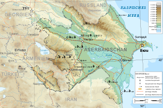
Azerbaijan is a country in the Caucasus region, situated at the juncture of Eastern Europe and West Asia. Three physical features dominate Azerbaijan: the Caspian Sea, whose shoreline forms a natural boundary to the east; the Greater Caucasus mountain range to the north; and the extensive flatlands at the country's center. [1] About the size of Portugal or the US state of Maine, Azerbaijan has a total land area of approximately 86,600 km², less than 1% of the land area of the former Soviet Union. [1] Of the three Transcaucasian states, Azerbaijan has the greatest land area. [1] Special administrative subdivisions are the Nakhchivan Autonomous Republic, which is separated from the rest of Azerbaijan by a strip of Armenian territory, and the Nagorno-Karabakh Autonomous Region, entirely within Azerbaijan. [1] The status of Nagorno-Karabakh is disputed by Armenia, but is internationally recognized as territory of Azerbaijan.

Contents

Located in the region of the southern Caucasus Mountains, Azerbaijan borders the Caspian Sea to the east, Georgia and Russia to the north, Iran to the south, and Armenia to the southwest and west. [1] A small part of Nakhchivan also borders Turkey to the northwest. [1] The capital of Azerbaijan is the ancient city of Baku, which has the largest and best harbor on the Caspian Sea and has long been the center of the republic's oil industry. [1] [2] [3]

Topography and drainage

Topographic map of Azerbaijan Azerbaijan topographic map-de.svg
Topographic map of Azerbaijan

The elevation changes over a relatively short distance from lowlands to highlands; nearly half the country is considered mountainous. [1] Notable physical features are the gently undulating hills of the subtropical southeastern coast, which are covered with tea plantations, orange groves, and lemon groves; numerous mud volcanoes and mineral springs in the ravines of Kobustan Mountain near Baku; and coastal terrain that lies as much as twenty-eight meters below sea level. [1]

Except for its eastern Caspian shoreline and some areas bordering Georgia and Iran, Azerbaijan is ringed by mountains. [1] To the northeast, bordering Russia's Dagestan Autonomous Republic, is the Greater Caucasus range; to the west, bordering Armenia, is the Lesser Caucasus range. [1] To the extreme southeast, the Talysh Mountains form part of the border with Iran. [1] The highest elevations occur in the Greater Caucasus, where Mount Bazardüzü rises 4,466 meters above sea level. [1] Eight large rivers flow down from the Caucasus ranges into the central Kura-Aras Lowlands, alluvial flatlands and low delta areas along the seacoast designated by the Azerbaijani name for the Mtkvari River (Kura) and its main tributary, the Aras. [1] The Mtkvari, the longest river in the Caucasus region, forms the delta and drains into the Caspian a short distance downstream from the confluence with the Aras. [1] The Mingechaur Reservoir, with an area of 605 square kilometers that makes it the largest body of water in Azerbaijan, was formed by damming the Kura in western Azerbaijan. [1] The waters of the reservoir provide hydroelectric power and irrigation of the Kura-Aras plain. [1] Most of the country's rivers are not navigable. [1] About 15% of the land in Azerbaijan is arable. [1]

Azerbaijan adm location map.svg
Red pog.svg
Baku
Red pog.svg
Ganja
Red pog.svg
Sumqayit
Red pog.svg
Mingachevir
Red pog.svg
Qaraçuxur
Red pog.svg
Shirvan
Red pog.svg
Nakhchivan City
Red pog.svg
Bakıxanov
Red pog.svg
Shaki
Red pog.svg
Yevlakh
Red pog.svg
Khankedi
Red pog.svg
Lankaran
Map of Azerbaijan

Mountains

The country's highest peak, Bazardüzü, rises to 4,485 m in this range at the Azerbaijan-Russia border.

Climate

Temperature

The climate varies from subtropical and humid in the southeast to subtropical and dry in central and eastern Azerbaijan, continental and humid in the mountains, and continental and dry in Nakhchivan. Baku, on the Caspian, enjoys mild weather that averages 4 °C (39.2 °F) in January and 25 °C (77 °F) in July. [4]

Precipitation

Physiographic conditions and different atmosphere circulations admit 8 types of air currents including continental, sea, arctic, tropical currents of air that formulates the climate of the Republic. The maximum annual precipitation falls in Lenkeran (1,600 to 1,800 mm.) and the minimum in Absheron (200 to 350 mm.). The maximum daily precipitation of 334 mm was observed at the Bilieser Station in 1955. [5]

Environmental problems

Subtle changes due to rising sea level can be seen along this coastline. Flooding in Azerbaijan.jpg
Subtle changes due to rising sea level can be seen along this coastline.

Air and water pollution are widespread and pose great challenges to economic development. [1] Major sources of pollution include oil refineries and chemical and metallurgical industries, which in the early 1990s continued to operate as inefficiently as they had in the Soviet era. [1] Air quality is extremely poor in Baku, the center of oil refining. [1] Some reports have described Baku's air as the most polluted in the former Soviet Union, and other industrial centers suffer similar problems. [1]

The Caspian Sea, including Baku Bay, has been polluted by oil leakages and the dumping of raw or inadequately treated sewage, reducing the yield of caviar and fish. [1] In the Soviet period, Azerbaijan was pressed to use extremely heavy applications of pesticides to improve its output of scarce subtropical crops for the rest of the Soviet Union. [1] The continued regular use of the pesticide DDT in the 1970s and 1980s was an egregious lapse, although that chemical was officially banned in the Soviet Union because of its toxicity to humans. [1] Excessive application of pesticides and chemical fertilizers has caused extensive groundwater pollution and has been linked by Azerbaijani scientists to birth defects and illnesses. [1] Rising water levels in the Caspian Sea, mainly caused by natural factors exacerbated by man-made structures, have reversed the decades-long drying trend and now threaten coastal areas; the average level rose 1.5 meters between 1978 and 1993. [1] Because of the Nagorno-Karabakh conflict, large numbers of trees were felled, roads were built through pristine areas, and large expanses of agricultural land were occupied by military forces. [1]

Like other former Soviet republics, Azerbaijan faces a gigantic environmental cleanup complicated by the economic uncertainties left in the wake of the Moscow-centered planning system. [1] The Committee for the Protection of the Natural Environment is part of the Azerbaijani government, but in the early 1990s it was ineffective at targeting critical applications of limited funds, establishing pollution standards, or monitoring compliance with environmental regulations. [1] Early in 1994, plans called for Azerbaijan to participate in the international Caspian Sea Forum, sponsored by the European Union (EU). [1]

Natural hazards
Droughts and floods; some lowland areas threatened by rising levels of the Caspian Sea
Environment—current issues
Local scientists consider the Abseron Yasaqligi (Apsheron Peninsula) (including Baky and Sumqayit) and the Caspian Sea to be the ecologically most devastated area in the world because of severe air, water, and soil pollution; soil pollution results from the use of DDT as a pesticide and also from toxic defoliants used in the production of cotton.
Environment - international agreements

Area and boundaries

Area
  • Total: 86,600 km²
    • country rank in the world: 113rd
  • Land: 82,629 km²
  • Water: 3,971 km²
  • Note: Includes the exclave of Nakhchivan Autonomous Republic and the Nagorno-Karabakh region; the region's autonomy was abolished by Azerbaijani Supreme Soviet on November 26, 1991.
Area comparative
  • Australia comparative: approximately 2/7 larger than Tasmania
  • Canada comparative: approximately 1/5 larger than New Brunswick
  • United Kingdom comparative: slightly larger than Scotland
  • United States comparative: slightly smaller than Maine
  • EU comparative: slightly smaller than Portugal
Land boundaries
  • Total: 2,468 km
  • Border countries: Armenia (with Azerbaijan-proper) 566 km, Armenia (with Azerbaijan-Nakhchivan exclave) 221 km, Georgia 428 km, Iran (with Azerbaijan-proper) 432 km, Iran (with Azerbaijan-Nakhchivan exclave) 700 km, Russia 338 km, Turkey 17 km
Coastline
Mostly landlocked, but has a 713 km coastline with the Caspian Sea.
Maritime claims
None
Terrain
  • large, flat lowland (much of it below sea-level) with Great Caucasus Mountains to the north, uplands in the west
Elevation extremes
  • Lowest point: Caspian Sea -28 m
  • Highest point: Bazardüzü 4,466 m (on the border with Russia)
  • Highest peak entirely within Azeri territory: Shah Dagi 4,243 m

Islands

Resources and land use

Natural resources
Petroleum, natural gas, iron ore, nonferrous metals, bauxite
Land use
  • Arable land: 22.95%
  • Permanent crops: 2.79%
  • Other: 74.26% (2012 est.)
Irrigated land
  • 14,250 km² (2010)
Total renewable water resources
  • 34.68 km3 (2011)
Freshwater withdrawal (domestic/industrial/agricultural)
  • Total: 12.21 km3/yr (4%/18%/78%)
  • Per capita: 1,384 cu m/yr (2010)

See also

Related Research Articles

<span class="mw-page-title-main">Azerbaijan</span> Country straddling West Asia and Eastern Europe in the Caucusus

Azerbaijan, officially the Republic of Azerbaijan, is a transcontinental country located at the boundary of Eastern Europe and West Asia. It is a part of the South Caucasus region and is bounded by the Caspian Sea to the east, Russia to the north, Georgia to the northwest, Armenia and Turkey to the west, and Iran to the south. Baku is the capital and largest city.

<span class="mw-page-title-main">Geography of Armenia</span> Overview of the geography of Armenia

Armenia is a landlocked country in the South Caucasus region of the Caucasus. The country is geographically located in West Asia, within the Armenian plateau. Armenia is bordered on the north and east by Georgia and Azerbaijan and on the south and west by Iran, Azerbaijan's exclave Nakhchivan, and Turkey.

<span class="mw-page-title-main">Transport in Azerbaijan</span> Overview of the transport in Azerbaijan

The transport in Azerbaijan involves air traffic, waterways and railroads. All transportation services in Azerbaijan except for oil and gas pipelines are regulated by the Ministry of Transportation of Azerbaijan Republic.

<span class="mw-page-title-main">Kura (river)</span> River in the Caucasus region

The Kura is an east-flowing river south of the Greater Caucasus Mountains which drains the southern slopes of the Greater Caucasus east into the Caspian Sea. It also drains the north side of the Lesser Caucasus, while its main tributary, the Aras, drains the south side of those mountains. Starting in northeastern Turkey, the Kura flows through Turkey to Georgia, then to Azerbaijan, where it receives the Aras as a right tributary, and enters the Caspian Sea at Neftçala. The total length of the river is 1,515 kilometres (941 mi).

<span class="mw-page-title-main">Nakhchivan Autonomous Republic</span> Exclave of Azerbaijan

The Nakhchivan Autonomous Republic is a landlocked exclave of the Republic of Azerbaijan. The region covers 5,502.75 km2 (2,124.62 sq mi) with a population of 459,600. It is bordered by Armenia to the east and north, Iran to the southwest, and Turkey to the west. It is the sole autonomous republic of Azerbaijan, governed by its own elected legislature.

Articles related to the Azerbaijan Republic include:

<span class="mw-page-title-main">Aras (river)</span> River located in and along the countries of Iran, Armenia, Azerbaijan, and Turkey

The Aras is a river in the Caucasus. It rises in eastern Turkey and flows along the borders between Turkey and Armenia, between Turkey and the Nakhchivan exclave of Azerbaijan, between Iran and both Azerbaijan and Armenia, and, finally, through Azerbaijan where it flows into the Kura river. It drains the south side of the Lesser Caucasus Mountains while the Kura drains the north side of the Lesser Caucasus. The river's total length is 1,072 km (666 mi) and its watershed covers an area of 102,000 km2 (39,000 sq mi). The Aras is one of the longest rivers in the Caucasus.

<span class="mw-page-title-main">Nakhichevan Autonomous Soviet Socialist Republic</span> Autonomous republic within the Azerbaijan SSR (1921–1990)

The Nakhichevan Autonomous Soviet Socialist Republic, abbreviated as Nakhichevan ASSR was an autonomous republic within the Azerbaijan SSR, itself a republic within the Soviet Union. It was formed on 16 March 1921 and became a part of the Azerbaijan SSR proper on 9 February 1924.

<span class="mw-page-title-main">Sadarak District</span> District of Nakhchivan Autonomous Republic in Azerbaijan

Sadarak District is one of the 7 districts of the Nakhchivan Autonomous Republic of Azerbaijan. The district borders the district of Sharur, as well as the Iğdır Province of Turkey, Ararat Province of Armenia and the West Azerbaijan Province of Iran. Its capital is Heydarabad and largest settlement is Sadarak. As of 2020, the district had a population of 16,100.

<span class="mw-page-title-main">History of Azerbaijan</span>

The history of Azerbaijan is understood as the history of the region now forming the Republic of Azerbaijan. Topographically, the land is contained by the southern slopes of the Caucasus Mountains in the north, the Caspian Sea in the east, and the Armenian Highlands in the west. In the south, its natural boundaries are less distinct, and here the country merges with the Iranian Plateau.

<span class="mw-page-title-main">Environment of Azerbaijan</span>

The environment of Azerbaijan, includes a wide diversity of climates, animals, plants, and habitats.

<span class="mw-page-title-main">Karabakh</span> Region in Azerbaijan and Armenia

Karabakh is a geographic region in southwestern Azerbaijan and eastern Armenia, extending from the highlands of the Lesser Caucasus down to the lowlands between the rivers Kura and Aras. It is divided into three regions: Highland Karabakh, Lowland Karabakh, and the eastern slopes of the Zangezur Mountains.

Armenians in Azerbaijan are the Armenians who lived in great numbers in the modern state of Azerbaijan and its precursor, Soviet Azerbaijan. According to the statistics, about 500,000 Armenians lived in Soviet Azerbaijan prior to the outbreak of the First Nagorno-Karabakh War in 1988. Most of the Armenians in Azerbaijan had to flee the republic, like Azerbaijanis in Armenia, in the events leading up to the First Nagorno-Karabakh War, a result of the ongoing Armenian-Azerbaijani conflict. Atrocities directed against the Armenian population took place in Sumgait, Ganja and Baku. Armenians continued to live in large numbers in the region of Nagorno-Karabakh, which was controlled by the break-away state known as the Nagorno-Karabakh Republic from 1991 until the region was forcibly retaken by Azerbaijan in 2023. After the Azerbaijani takeover, almost all Armenians living in Nagorno-Karabakh left the region.

<span class="mw-page-title-main">Outline of Azerbaijan</span> Country in the Caucasus region of Eurasia

The following outline is provided as an overview of and topical guide to Azerbaijan:

Karabakh is a geographic region in present-day eastern Armenia and southwestern Azerbaijan, extending from the highlands of the Lesser Caucasus down to the lowlands between the rivers Kura and Aras

<span class="mw-page-title-main">Military history of Azerbaijan</span> Aspect of military history

The military history of Azerbaijan is framed within thousands of years of armed actions of many other states in the territory encompassing modern Azerbaijan, as well as the shorter history of interventions by the Azerbaijani Armed Forces in conflicts abroad. The Azerbaijanis are the inheritors of the lands of various ancient civilizations and peoples including the indigenous Caucasian Albanians, Iranian tribes such as Scythians and Alans, and Oghuz Turks among others.

<span class="mw-page-title-main">Azerbaijan Railways</span> National railway company of Azerbaijan

Azerbaijan Railways is the national state-owned rail transport operator in the Republic of Azerbaijan. The 2,918 km (1,813 mi), 1,520 mm gauge network is electrified at 3 kV (3,000 V) DC. The headquarters of the Azerbaijan Railways is in the capital Baku.

<span class="mw-page-title-main">Armenia–Azerbaijan border</span> International border

The Armenia–Azerbaijan border is the international border between Armenia and Azerbaijan. Estimates of the border's length vary from 996 km (619 mi) to 1,007.1 km (625.8 mi). European routes E002 and E117 cross the border.

<span class="mw-page-title-main">Azerbaijan–Iran border</span> International border

The Azerbaijan–Iran border is 689 km in length and consists of two non-contiguous sections separated by the Armenia–Iran border.

References

  1. 1 2 3 4 5 6 7 8 9 10 11 12 13 14 15 16 17 18 19 20 21 22 23 24 25 26 27 28 29 30 31 32 PD-icon.svg This article incorporates text from this source, which is in the public domain :Curtis, Glenn E. (1995). Armenia, Azerbaijan, and Georgia : country studies (1st ed.). Washington, D.C.: Federal Research Division. pp. 99–101. ISBN   0-8444-0848-4. OCLC   31709972.
  2. "CIA Site Redirect — Central Intelligence Agency". www.cia.gov. Archived from the original on October 17, 2000. Retrieved 2018-03-07.
  3. "The World Factbook — Central Intelligence Agency". www.cia.gov. Archived from the original on June 13, 2007. Retrieved 2018-03-07.
  4. "Azərbaycan :: Baş səhifə". www.azerbaijans.com (in Azerbaijani). Retrieved 2018-03-07.
  5. "Hydromet Azerbaijan". Archived from the original on 2007-05-24. Retrieved 2018-10-02.

General references