Mountains of Azerbaijan

Last updated

Mountains of Azerbaijan cover approximately 60 percent of the country's land area. [1] [2] There are three mountain ranges in the territory of Azerbaijan, which are the Greater Caucasus, the Lesser Caucasus, and the Talysh Mountains. [3]

Contents

The elevation of the central mountains of these three mountain ranges is approximately 1000 – 2000 meters. [1]  The height of high mountains of the Greater Caucasus is higher than 2200 meters and the Lesser Caucasus is higher than 2000 meters. [1]

Mountain ranges in Azerbaijan [1]
Mountain rangesArea coverage (%)Zones
Greater Caucasus30Foothill (lower than 500 meters)
Low mountains (500 – 1200 meters)
Middle mountain (1200 – 2200 meters)
High mountains (higher than 2200 meters)
Lesser Caucasus22Foothill (lower than 500 meters)
Low mountains (500 – 1200 meters)
Middle mountain (1200 – 2000 meters)
High mountains (higher than 2000 meters)
Talysh Mountains6Pre – mountain plains (lower than 600 meters)
Low mountains (600 – 1000 meters)
Middle mountain (1000 – 2500 meters)

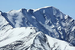
The Greater Caucasus range forms the north-east borders of Azerbaijan with Dagestan Autonomous Republic of Russia. [4] Bazarduzu, Shahdagh, and Tufandag are the high peaks of the mountain range. [5] The highest peak of the Greater Caucasus is Mount Bazarduzu, which is situated 14,652 feet (4,466 meters) above the sea level, is also the highest point in Azerbaijan. [3] [5] The mountains of the Greater Caucasus are located in the region of high degree of seismic activity. [5] The mountains are formed by rocks that date back to Jurassic and Cretaceous periods. [2]

The Lesser Caucasus is the second important mountain range in Azerbaijan and forms its south-western borders. [5] Mount Murovdag and Mount Zangezur are the main ridges of the Lesser Caucasus. [5] They are formed by sedimentary and volcanogenic rocks of Cretaceous and Jurassic periods. [2]

The Talysh Mountains cover the southeastern part of Azerbaijan and form part of its border with Iran. [4] [5]

Mountains of the Greater Caucasus

Bazarduzu (Azerbaijani Bazarduzu) - is the highest mountain in Azerbaijan (4466 m) Bazarduzu detail.JPG
Bazarduzu (Azerbaijani Bazardüzü) - is the highest mountain in Azerbaijan (4466 m)

Bazarduzu

The highest peak of the Greater Caucasus, Mount Bazarduzu, is the highest mountain in Azerbaijan. [3] [6] It lies on the borders between Azerbaijan and Russia. [3] The rocks of Mount Bazarduzu are formed of shale porphyries. [7]  Ice fields that consist of glaciers from Ice Age on the mountain are the biggest glaciers in the Eastern Caucasus. [7]

The first person who climbed the Mount Bazarduzu was Aleksej Aleksandrov from Russia in 1847. [3] [7]

Mount Shahdagh Shakhdag.jpg
Mount Shahdagh

Shahdagh

Mount Tufandag Tufandag 1.jpg
Mount Tufandag

The elevation of Mount Shahdagh is 13,951 feet (4,252 m), which is the second highest peak in the Greater Caucasus. [3] [8] The mountain is located near to the border with Russia, in Gusar region of Azerbaijan. [3] There are caves at the base of the Mount Shahdagh, which show manmade activities around the mountain for over 9000 years. [3] The rocks of the mountain are formed by dolomites and limestones. [8]

Tufandag

Tufandağ is the third highest mountain in Azerbaijan with the height of 13,770 feet (4,200 m).). [3]  Mount Tufandag lies in the Gusar region. [9]

List of mountains of the Greater Caucasus [9]
NameOriginal nameElevation (m)Region
BazarduzuBazardüzü4466Russian – Gusar border
ShahdaghŞahdağ4243Gusar
TufandagTufandağ4191Gusar
BazaryurdBazaryurd4126Gusar and Gabala
YarudagYarıdağ4116Gusar
Chingiz MustafayevÇingiz Mustafayev4062Guba
Ilham Peakİlham zirvəsi4042Gusar
Heydar PeakHeydər zirvəsi3751Gusar
KhinaligXınalıq3713Guba
RagdanRaqdan4020Gabala
BabadagBabadağ3629Ismayilli
AtatürkAtatürk3759Guba
Olympia PeakOlimpiya zirvəsi3455Gusar
AteshgahAtəşgah2151Guba
Gizil GayaQızıl Qaya3726Guba

Mountains of Lesser Caucasus

Murovdag (Azerbaijani: Murovdag) Murov mountain in Azerbaijan-Caucasus3.jpg
Murovdag (Azerbaijani: Murovdağ)

Murovdag

Within the Lesser Caucasus, the highest mountain ridge is Murovdag. [10]  The range of the mountain is approximately 70 kilometers. [10]

Gamishdag

Mount Kaputjukh Kaputdzukh 1991.jpg
Mount Kaputjukh

The highest peak of the Murovdag ridge is Gamishdag and its elevation is 3724 meters. [11]

Zangezur

The Zangezur mountain ridge bordered with Aghdaban peak in north-west and Araz river in south-east. [12] The range of the Zangezur ridge is approximately 130 kilometers. [12] In the center and south-east parts of the ridge, there are Gamigaya, Kaputjukh, Garangush, Davabouynu, Aychingil peaks. [12] Prominent mountains of the Zangezur ridge are Nahajir, Alinja, Ilandag, Gurddag, and Gizilboghaz mountains. [12]

Kaputjukh

Mount Kaputjukh is the highest peak of the Zangezur ridge and the highest mountain in the Lesser Caucasus. [11] [13] The height of the mountain is 3904 meters. [11] [13] It lies in Ordubad region of Nakhchivan. [13]  There are ancient Gamigaya inscriptions on the rocks that are at the bottom of the mountain. [13]

Alinja

Mount Alinja Alinja mountain.jpg
Mount Alinja

Mount Alinja is located in Julfa region of Nakhchivan, on the shore of the river with the same name as mountain. [13]  The elevation of Mount Alinja is 1811 meters. [13]  It has volcanic origins. [13]

List of mountains of the Lesser Caucasus [14]
NameOriginal nameElevation (m)Ridge
KaputjukhQapıcıq3904Zangezur
DalidagDəlidağ3616Garabagh volcanic highland
GamishGamışdağ3724Murovdag
KapazKəpəz3066Murovdag
GoshgarQoşqar3361Murovdag
HinaldagHinaldağ3367Murovdag
GizilboghazQızılboğaz3581Garabagh volcanic highland
Boyuk IshigliBöyük Işıqlı3550Garabagh volcanic highland
AlinjaƏlincə1811Zangezur

Talysh Mountains

Talysh mountains in Masalli, Azerbaijan. Masalli08.jpg
Talysh mountains in Masalli, Azerbaijan.

Talysh mountains are located in the south – east of Azerbaijan.  There are three mountain ridge within the Talysh mountains, which of elevations reach 2477 meters. [2]  They are Talysh, Burovar, and Peshteser. [2]  There are few peaks that of heights are above 3,000 meters (9,800 feet). [15] The rocks of the mountains originated from volcanic rocks and carbonate rocks that date back to the Jurassic, Cretaceous, and Paleogene periods. [15]

Kyumyurkyoy

The highest peak of Talysh mountains is the Mount Kyumyurkyoy (2493 meters). [5]

Gizyurdu

Mount Gizyurdu is the second highest peak of Talysh mountains with the height of 2433 meters. [14]

List of the highest peaks of Talysh Mountains [14]
NameOriginal nameElevation (m)
KyumyurkyoyGömürgöy2493
GizyurduQızyurdu2433

Other mountains

Mount Goyazan 11122501 749970995120279 1199669576 n 01.jpg
Mount Goyazan
Yanar Dag Yanar Dag, Azerbaijan 1.jpg
Yanar Dag

Mount Goyazan

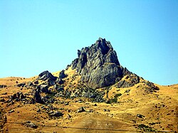
The elevation of Mount Goyazan is located 20 kilometers far from Qazakh district of Azerbaijan. [16]  Its elevation is 250 meters. [16] The mountain has volcanic origin and it is not connected to any mountain ridges. [16] At the bottom of the mountain, there are ancient dwellings. [16]

Yanar Dag

Yanar Dag is located 27 kilometers far from Baku. [17]  On the surface of Yanar Dag, there are fires of natural gas that flames continuously, and their height reaches to 10–15 meters. [17]

The historical-cultural and natural reserve was established in the territory of Yanar Dag by the presidential decree dated May 2, 2007. [17]

See also

Related Research Articles

<span class="mw-page-title-main">Geography of Azerbaijan</span> Overview of the geography of Azerbaijan

Azerbaijan is a country in the Caucasus region, situated at the juncture of Eastern Europe and West Asia. Three physical features dominate Azerbaijan: the Caspian Sea, whose shoreline forms a natural boundary to the east; the Greater Caucasus mountain range to the north; and the extensive flatlands at the country's center. About the size of Portugal or the US state of Maine, Azerbaijan has a total land area of approximately 86,600 km², less than 1% of the land area of the former Soviet Union. Of the three Transcaucasian states, Azerbaijan has the greatest land area. Special administrative subdivisions are the Nakhchivan Autonomous Republic, which is separated from the rest of Azerbaijan by a strip of Armenian territory, and the Nagorno-Karabakh Autonomous Region, entirely within Azerbaijan. The status of Nagorno-Karabakh is disputed by Armenia, but is internationally recognized as territory of Azerbaijan.

<span class="mw-page-title-main">Geography of Armenia</span> Overview of the geography of Armenia

Armenia is a landlocked country in the South Caucasus region of the Caucasus. The country is geographically located in West Asia, within the Armenian plateau. Armenia is bordered on the north and east by Georgia and Azerbaijan and on the south and west by Iran, Azerbaijan's exclave Nakhchivan, and Turkey.

<span class="mw-page-title-main">Caucasus Mountains</span> Mountain system at the intersection of Europe, Asia, and the Middle East

The Caucasus Mountains is a mountain range at the intersection of Asia and Europe. Stretching between the Black Sea and the Caspian Sea, they are surrounded by the Caucasus region and are home to Mount Elbrus, the highest peak in Europe at 5,642 metres (18,510 ft) above sea level.

<span class="mw-page-title-main">Gadabay District</span> District of Azerbaijan

Gadabay District is one of the 66 districts of Azerbaijan. It is located in the west of the country and belongs to the Gazakh-Tovuz Economic Region. The district borders the districts of Dashkasan, Shamkir, Tovuz, and the Gegharkunik and Tavush provinces of Armenia. The Artsvashen exclave of Armenia is surrounded by the Gadabay District and is de facto controlled by Azerbaijan, administrated as part of Goranboy District. Its capital and largest city is Gadabay. As of 2020, the district had a population of 109,900.

<span class="mw-page-title-main">Qabala District</span> District of Azerbaijan

Qabala District is one of the 69 districts of Azerbaijan. It is located in the north of the country in the Shaki-Zagatala Economic Region. The district borders the districts of Oghuz, Shaki, Agdash, Goychay, Ismayilli, Quba, Qusar, and the Russian Republic of Dagestan. Its capital and largest city is Qabala. As of 2020, the district had a population of 107,800.

<span class="mw-page-title-main">Lesser Caucasus</span> Mountain system

The Lesser Caucasus or Lesser Caucasus Mountains, also called Caucasus Minor, is the second of the two main ranges of the Caucasus Mountains, of length about 600 km (370 mi). The western portion of the Lesser Caucasus overlaps and converges with east Turkey and northwest Iran. It runs parallel to the Greater Caucasus, at a distance averaging about 100 km (62 mi) south from the Likhi Range (Georgia) and limits east Turkey from the north and north-east. It is connected to the Greater Caucasus by the Likhi Range (Georgia) and separated from it by the Kolkhida Lowland (Georgia) in the west and Kura-Aras Lowland (Azerbaijan) in the east.

<span class="mw-page-title-main">Mount Bazardüzü</span> Mountain in Russia and Azerbaijan

Mount Bazardüzü is a mountain peak in the Greater Caucasus range on the border between Russia (Dagestan) and Azerbaijan. At 4,466 metres (14,652 ft) above sea level, it is the highest peak in both Dagestan and Azerbaijan, and is located in the Qusar region. The southernmost point of Dagestan is located about seven kilometers southwest of the peak. Translated from Azerbaijani, Bazarduzu means “market square”, more precisely as a specific landmark - “turn to the market, bazaar”. In the Middle Ages in the Shahnabad Valley, located east of this peak, annual large multinational fairs were held.

<span class="mw-page-title-main">Environment of Azerbaijan</span>

The environment of Azerbaijan, includes a wide diversity of climates, animals, plants, and habitats.

<span class="mw-page-title-main">Orography of Azerbaijan</span>

Orography of Azerbaijan refers to the rocky, mountainous and elevated terrains in Azerbaijan. The tectonic structure is typical for the orography of the country. The main morphostructural units are the Greater Caucasus, the Lesser Caucasus, the Gusar plane, the Samur-Devechi lowland, the Kur intermountain trough, the Karabagh volcanic highland, the near and middle Araz Ridges and Talysh Mountains.

<span class="mw-page-title-main">Mount Shahdagh</span> Mountain in northern Azerbaijan

Mount Shahdagh is a mountain peak of the Greater Caucasus range, located in the Qusar District of Azerbaijan, close to the border with Russia. The elevation of the peak is 4,243 metres (13,921 ft) above sea level.

<span class="mw-page-title-main">Murovdağ</span> Mountain range in the Lesser Caucasus

The Murovdağ or Mrav is the highest mountain range in the Lesser Caucasus. The range is about 70 kilometres (43 mi) long, and Gamish Mountain is its highest peak at 3,724 metres (12,218 ft). It is made up mainly of Jurassic, Cretaceous and Paleogene rocks.

<span class="mw-page-title-main">Tourism in Azerbaijan</span>

Tourism in Azerbaijan has been an important sector of the Azerbaijani economy since the 1990s. According to Azerbaijan's Center for Economic and Social Development, the country is in 39th place among 148 countries in tourism competitiveness indicators. The World Travel and Tourism Council reported that Azerbaijan is among the top ten countries with the greatest increase in visitor exports from 2010 to 2016. The country had the world's fastest-developing travel and tourism economy in 2017. To promote tourism, Azerbaijan sponsored Atlético Madrid jerseys reading "Azerbaijan – Land of Fire". In 2018, a new tourism brand and a slogan "take another look" were introduced.

<span class="mw-page-title-main">Buzeyir cave</span> Cave and archaeological site in Azerbaijan

Buzeyir cave – is an archaeological site and Paleolithic place of human habitation. The cave is located on the left bank of the Zuvandchay River, at the top of Delikli-Dash Mountain, 3 km (1.9 mi) at an altitude of 1,640 m (5,380 ft) above sea level and to the east of Büzeyir village in Lerik Rayon, Azerbaijan.

<span class="mw-page-title-main">Geology of Armenia</span>

The geology of Armenia was shaped by geological upheaval pushed up the Earth's crust to form the Armenian Plateau 25 million years ago. This created the complex topography of Armenia.

Republic is a high peak in Gusar District of Azerbaijan. It is part of the Greater Caucasus mountain range, with a summit elevation of 12,270 feet (3,740 m) above sea level. The peak was named Republic and a monument was built on the peak dedicated to 100th anniversary of the Azerbaijan Democratic Republic on 28 May. A road to the mountain peak was opened on 3 May, while the first climb occurred on 28 May, 2018. The project was part of the Azerbaijani President Ilham Aliyev's "Year of the Republic" order.

<span class="mw-page-title-main">Tourism in Nakhchivan Autonomous Republic</span>

The Nakhchivan Autonomous Republic is one of the touristic regions of Azerbaijan with its flora and fauna, climate, and ancient cultural monuments. Nakhchivan is known for its historical monuments such as Momuna Khatun, Yusif ibn Kuseyir, Gulustan tombs, and Garabaghlar. There are other touristic places like Babek castle, Kilit cave, Alinja castle, and Gamigaya in Nakhchivan.

<span class="mw-page-title-main">Tufandağ</span> Mountain in northern Azerbaijan

Tufandagh is a mountain peak of the Greater Caucasus range, located in the Qusar District of Azerbaijan. With an elevation of 4,191 metres (13,750 ft) above sea level, it third highest mountain in Azerbaijan.

<span class="mw-page-title-main">Main Caucasian Range</span> Mountain range in Russia, Georgia and Azerbaijan

The Main Caucasian Range is a mountain range in the Russian Federation, Georgia and Azerbaijan. It is the dividing range of the Greater Caucasus.

References

  1. 1 2 3 4 Price, Martin (2000). Cooperation in the European Mountains 2: The Caucasus. Switzerland: IUCN. ISBN   2831705347.
  2. 1 2 3 4 5 "Azerbaijan". azerbaijan.az. Archived from the original on 2018-08-29. Retrieved 2018-08-27.
  3. 1 2 3 4 5 6 7 8 9 "Tallest Mountains in Azerbaijan". WorldAtlas. Retrieved 2018-08-27.
  4. 1 2 Suny, Ronal (1996). Armenia, Azerbaijan, and Georgia. United States: DIANE Publishing. ISBN   0788128132.
  5. 1 2 3 4 5 6 7 "Azerbaijan | History, People, & Facts". Encyclopedia Britannica. Retrieved 2018-08-27.
  6. Verda, Matteo (2014). Azerbaijan: An introduction to the Country. Italy: Edizioni Epoké. ISBN   9788898014361.
  7. 1 2 3 "Bazardüzü : Climbing, Hiking & Mountaineering : SummitPost". www.summitpost.org. Retrieved 2018-08-28.
  8. 1 2 "Шах-даг - Энциклопедия, Брокгауз-Ефрон". gatchina3000.ru (in Russian). Retrieved 2018-08-28.
  9. 1 2 "Zirvələr | Azərbaycan Respublikası Ekologiya və Təbii Sərvətlər Nazirliyi". eco.gov.az (in Azerbaijani). Retrieved 2018-08-28.
  10. 1 2 "Satellite map of Murovdag, Azerbaijan. Latitude: 40.2667 Longitude: 46.3167". Latitude.to, maps, geolocated articles, latitude longitude coordinate conversion. Retrieved 2018-08-29.
  11. 1 2 3 Alizadeh, Akif; Guliyev, Ibrahim; Kadirov, Fakhraddin; Eppelbaum, Lev (2016). Geosciences of Azerbaijan: Volume I: Geology. Switzerland: Springer. ISBN   9783319273952.
  12. 1 2 3 4 Budagov, Budag (2005). Naxçıvan ensiklopediyası: II cild (in Azerbaijani). Nakhchivan. ISBN   5-8066-1468-9.{{cite book}}: CS1 maint: location missing publisher (link)
  13. 1 2 3 4 5 6 7 Bunyadov, Teymur (2005). Naxçıvan ensiklopediyası: I cild (in Azerbaijani). Nakhchivan. ISBN   5-8066-1468-9.{{cite book}}: CS1 maint: location missing publisher (link)
  14. 1 2 3 "Azərbaycanın relyefi". Kayzen (in Azerbaijani). Retrieved 2018-08-30.
  15. 1 2 "Talish Mountains | mountains, Azerbaijan-Iran". Encyclopedia Britannica. Retrieved 2018-08-30.
  16. 1 2 3 4 "Göyəzən dağı". gazakh.cls.az (in Azerbaijani). Retrieved 2018-08-30.
  17. 1 2 3 ""Yanardağ" Dövlət Tarix-Mədəniyyət və Təbiət Qoruğu - Tarixi qoruqlar | Kataloq GoMap.Az". kataloq.gomap.az (in Azerbaijani). Retrieved 2018-08-30.