Related Research Articles

Jan Mayen is a Norwegian volcanic island in the Arctic Ocean with no permanent population. It is 55 km (34 mi) long (southwest-northeast) and 373 km2 (144 sq mi) in area, partly covered by glaciers. It has two parts: larger northeast Nord-Jan and smaller Sør-Jan, linked by a 2.5 km (1.6 mi) wide isthmus. It lies 600 km (370 mi) northeast of Iceland, 500 km (310 mi) east of central Greenland, and 900 km (560 mi) northwest of Vesterålen, Norway. The island is mountainous, the highest summit being the Beerenberg volcano in the north. The isthmus is the location of the two largest lakes of the island, Sørlaguna and Nordlaguna. A third lake is called Ullerenglaguna. Jan Mayen was formed by the Jan Mayen hotspot and is defined by geologists as a microcontinent.

Plate tectonics is the scientific theory that Earth's lithosphere comprises a number of large tectonic plates, which have been slowly moving since about 3.4 billion years ago. The model builds on the concept of continental drift, an idea developed during the first decades of the 20th century. Plate tectonics came to be accepted by geoscientists after seafloor spreading was validated in the mid-to-late 1960s.
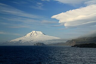
Beerenberg is a stratovolcano dominating the northeastern end of the Norwegian island of Jan Mayen. It is 2,277 m (7,470 ft) high and is the world's northernmost subaerial active volcano and the only active volcano in Norway. The volcano is topped by a mostly ice-filled crater about one kilometre wide, with numerous peaks along its rim including the highest summit, Haakon VII Toppen, on its western side.

The Ring of Fire is a tectonic belt of volcanoes and earthquakes.

The Scotia Plate is a minor tectonic plate on the edge of the South Atlantic and Southern oceans. Thought to have formed during the early Eocene with the opening of the Drake Passage that separates Antarctica and South America, it is a minor plate whose movement is largely controlled by the two major plates that surround it: the Antarctic Plate and the South American Plate. The Scotia Plate takes its name from the steam yacht Scotia of the Scottish National Antarctic Expedition (1902–04), the expedition that made the first bathymetric study of the region.
In hydrology, an oceanic basin (or ocean basin) is anywhere on Earth that is covered by seawater. Geologically, most of the ocean basins are large geologic basins that are below sea level.

The Greenland Sea is a body of water that borders Greenland to the west, the Svalbard archipelago to the east, Fram Strait and the Arctic Ocean to the north, and the Norwegian Sea and Iceland to the south. The Greenland Sea is often defined as part of the Arctic Ocean, sometimes as part of the Atlantic Ocean. However, definitions of the Arctic Ocean and its seas tend to be imprecise or arbitrary. In general usage the term "Arctic Ocean" would exclude the Greenland Sea. In oceanographic studies the Greenland Sea is considered part of the Nordic Seas, along with the Norwegian Sea. The Nordic Seas are the main connection between the Arctic and Atlantic oceans and, as such, could be of great significance in a possible shutdown of thermohaline circulation. In oceanography the Arctic Ocean and Nordic Seas are often referred to collectively as the "Arctic Mediterranean Sea", a marginal sea of the Atlantic.

The Kerguelen Plateau, also known as the Kerguelen–Heard Plateau, is an oceanic plateau and large igneous province (LIP) located on the Antarctic Plate, in the southern Indian Ocean. It is about 3,000 km (1,900 mi) to the southwest of Australia and is nearly three times the size of California. The plateau extends for more than 2,200 km (1,400 mi) in a northwest–southeast direction and lies in deep water.

The Kerguelen hotspot is a volcanic hotspot at the Kerguelen Plateau in the Southern Indian Ocean. The Kerguelen hotspot has produced basaltic lava for about 130 million years and has also produced the Kerguelen Islands, Naturaliste Plateau, Heard Island, the McDonald Islands, and Rajmahal Traps. One of the associated features, the Ninety East Ridge, is distinguished by its over 5,000 km (3,100 mi) length, being the longest linear tectonic feature on Earth. The total volume of magma erupted in 130 million years with associated features has been estimated to be about 25,000,000 km3 (6,000,000 cu mi). However, as well as large igneous provinces and seamounts the hotspot has interacted with other seafloor spreading features, so this volume figure has some uncertainty.

The geology of Turkey is the product of a wide variety of tectonic processes that have shaped Anatolia over millions of years, a process which continues today as evidenced by frequent earthquakes and occasional volcanic eruptions.

The Scotia Arc is the island arc system forming the north, east and south border of the Scotia Sea. The northern border, the North Scotia Ridge, comprises Isla de los Estados at the tip of Tierra del Fuego, the Burdwood, Davis, and Aurora Banks; the Shag, South Georgia Island and Clerke Rocks. The eastern border comprises the volcanic South Sandwich Islands flanked by the South Sandwich Trench. The southern border, the South Scotia Ridge, comprises Herdman, Discovery, Bruce, Pirie, and Jane Banks; the South Orkney Islands and Elephant Island. The Bransfield Strait, finally, separates the arc from the South Shetland Islands and James Ross Island flanking the tip of the Antarctic Peninsula.
Continental crustal fragments, partly synonymous with microcontinents, are pieces of continents that have broken off from main continental masses to form distinct islands that are often several hundred kilometers from their place of origin.

The following outline is provided as an overview of and introduction to Oceanography.

The Jan Mayen Microcontinent is a fragment of continental crust within the oceanic part of the western Eurasian Plate lying northeast of Iceland. At the onset of separation between the Greenland and Eurasian plates 55 million years ago, it formed part of the eastern margin of the Greenland Plate. Propagation of a new spreading center from the Reykjanes Ridge separated this microcontinent from the Greenland Plate. For a short period it formed a microplate, until the Aegir Ridge became inactive, after which it formed part of the Eurasian Plate. The island of Jan Mayen is a much younger feature, formed of volcanic rock, built up at the northernmost tip of the microcontinent.
The geology of the North Sea describes the geological features such as channels, trenches, and ridges today and the geological history, plate tectonics, and geological events that created them.
This is a list of articles related to plate tectonics and tectonic plates.
The Aegir Ridge is an extinct segment of the Mid-Atlantic Ridge in the far-northern Atlantic Ocean. It marks the initial break-up boundary between Greenland and Norway, along which seafloor spreading was initiated at the beginning of the Eocene epoch to form the northern Atlantic Ocean. Towards the end of the Eocene, the newly forming Kolbeinsey Ridge propagated northwards from Iceland, splitting the Jan Mayen Microcontinent away from the Greenland Plate. As the Kolbeinsey Ridge formed, so activity on the Aegir Ridge reduced, ceasing completely at the end of the Oligocene epoch when the Kolbeinsey Ridge reached the Jan Mayen Fracture Zone.

The Woodlark Plate is a small almost triangular shaped tectonic plate located east of the island of New Guinea and situated mainly within the northern half of the Woodlark Basin. It is located in a very complex tectonic environment, that because of associated features, has been extensively studied since it was first proposed to exist. It is now known to be much smaller than originally proposed, mainly because of information from GPS stations on islands and sea floor studies that have fully defined its margins.

Vesteris Seamount, also known as Vesteris Bank, is a seamount in the Greenland Sea of the North Atlantic Ocean between Greenland and Norway. It lies north of Jan Mayen and rises from 41–43 million years old ocean crust. The reasons for the volcanic activity at Vesteris are unclear and may involve lithospheric processes.
References
- ↑ "The geology of Jan Mayen - Norwegian Polar Institute". npolar.no. Norwegian Polar Institute. March 4, 2014. Archived from the original on March 20, 2019. Retrieved November 24, 2023.
- ↑ "Palaeocene–Recent plate boundaries in the NE Atlantic and the formation of the Jan Mayen microcontinent | Journal of the Geological Society". GeoScienceWorld. Retrieved 2018-10-25.
| | This Jan Mayen location article is a stub. You can help Wikipedia by expanding it. |
| | This geology article is a stub. You can help Wikipedia by expanding it. |