Geology of the Isle of Man

Last updated

The geology of the Isle of Man consists primarily of a thick pile of sedimentary rocks dating from the Ordovician period, together with smaller areas of later sedimentary and extrusive igneous strata. The older strata was folded and faulted during the Caledonian and Acadian orogenies The bedrock is overlain by a range of glacial and post-glacial deposits. Igneous intrusions in the form of dykes and plutons are common, some associated with mineralisation which spawned a minor metal mining industry.

Contents

Ordovician and Silurian

Layers of Ordovician sandstone of the Mull Hill Formation at The Chasms near the southwest end of the island Climbers at The Chasms - geograph.org.uk - 25500.jpg
Layers of Ordovician sandstone of the Mull Hill Formation at The Chasms near the southwest end of the island

The larger part of the island is formed from rocks of Ordovician age which were traditionally known as the Manx Slates but are now referred by geologists to the Manx Group. The relationships between the various different formations which constitute this sequence is often obscured by faulting but the sequence is considered to be:

All of these formations are of Arenig age with the exception of the lowermost which is Tremadocian. The Group is the equivalent of north-west England's Skiddaw Group and south-east Ireland's Ribband Group. [1] The Manx Group is poorly fossiliferous but acritarchs and graptolite provide some insight into the succession's biostratigraphy. The succession has been subject to low-grade metamorphism. [2] A microgabbro was intruded into rocks of the Creggan Mooar Formation to the east of Peel during this period. Manx Group sandstones were used in the construction of Peel Castle. [3] Snaefell, the high point of the Isle of Man, together with the ridge extending north-eastwards to the island's second highest summit, North Barrule are formed from the mudstones of the Barrule Formation. The same rocks also form the summit of South Barrule, highest summit in the south of the island. A celebrated site in the far south is 'The Chasms' where large fissures have opened up in the coastal cliffs of the Mull Hill Formation's quartz-arenites. Nearby Spanish Head and the Calf of Man are formed from Lonan Formation rocks.

Also included traditionally within the Manx Slates are a group of Silurian age rocks which outcrop along the coast between Niarbyl Point and Peel and which are nowadays referred to as the Niarbyl Formation. The Niarbyl rocks which were found on the basis of a graptolite discovery, to be of Wenlock age as recently as 1997 constitute the sole formation within the Dalby Group. This group equates with a part of the Windermere Supergroup in the southern Lake District and the Riccarton Group in southern Scotland. [4]

Ordovician/Silurian intrusives

A suite of dykes of Ordovician to Silurian age have been intruded into the rocks of the Manx and Dalby groups. Other than some exposed hillsides and stream sections they are not readily encountered inland but are well exposed along the rocky shores of the island south of Ramsey in the east and Kirk Michael in the west. Most common are metabasite dykes with a broadly NE-SW alignment. Dykes of a broadly similar age of granodiorite and microgranite are also to be found. The Dhoon pluton is composed of Ordovician/Silurian age granodiorite. It is exposed on the eastern flanks of Slieau Ruy west of the hamlet and also to the east where it has been quarried. The Oatlands pluton near Santon to the southwest of Douglas is formed from granite and microgabbro-diorite. A flooded quarry is a legacy of its previous exploitation at this site. There may be a granite batholith beneath the island. [5]

Devonian

Sandstone, part of the Peel Group, at Periwinkle Bay near Peel Cliffs at Peel - Isle of Man - geograph.org.uk - 31802.jpg
Sandstone, part of the Peel Group, at Periwinkle Bay near Peel

Reddish-brown sandstones of the Peel Group of early Devonian age are exposed along the coast for a mile north-east of Peel. These rocks extend for up to a mile inland but are covered by sands and gravels. The sequence, estimated to be between 500 and 2000m thick, is fluvial and aeolian in origin. It also contains conglomerates, and some concretionary limestone or calcretes which represent fossil soil horizons. [6] A scatter of diorite and lamprophyre dykes were emplaced during the early Devonian, the latter within the Niarbyl Formation rocks south of Peel. The Foxdale granite pluton was also emplaced at this time. It is worked at a quarry within the Stoney Mountain Plantation south-east of Foxdale village.

Carboniferous

A suite of sedimentary rocks was deposited during the Carboniferous period, the oldest being the Tournaisian age conglomerates, breccias and sandstones of the Langness Conglomerate Formation. These were succeeded in the Visean by a variety of limestones assigned to the Great Scar Limestone Group and finally by a range of rocks which compose the Craven Group. The limestones were formed in the Eubonia Basin, [7] occupied by a tropical sea as the Isle of Man was situated at the equator at this time. The only onshore representatives of this basin succession, these strata are found within three miles of Castletown; inland exposures are few but these rocks are well exposed along the coast between Kentraugh, east of St Mary and the Santon Burn south-east of Ballasalla.

Carboniferous rocks underlie the thick recent deposits north of Ramsey and around Andreas but are nowhere seen at the surface. At the top of the Carboniferous sequence, a suite of igneous rocks which outcrop on the eastern side of Bay ny Carrickey opposite Port St Mary which include tuffs, pillow lavas and debris flows are collected together as the Scarlett Volcanic Member. A number of basaltic and microgabbro dykes are thought to have been intruded into the Palaeozoic country rock during the Carboniferous period. [8]

Permo-Trias

Sandstones and mudstones from these two periods underlie the northernmost part of the island but are entirely obscured by thick Quaternary deposits.

Palaeogene

Olivine microgabbro dykes of Palaeogene age and with a broad NW-SE alignment are commonly exposed around the island's rocky coasts. A thick dyke in the north is connected to the Fleetwood Dyke as part of an en echelon series; this and other Palaeogene dykes appear to be associated with an igneous centre in Northern Ireland. [9]

Geological structures

The lower Palaeozoic rocks i.e. Ordovician and Silurian are intensely folded. Two main phases of deformation are recognised and usually considered to be Acadian, with deformation including the presence of shear zones being most intense in the west. [10] [11] They are also cut by faults developed largely on Caledonoid lines i.e. with a north-east to southwest orientation. Some multi-kilometre scale folds are named such as the Port Erin and Dhoon anticlines and the Douglas Syncline. Several south-east directed thrust faults are mapped across the island. The Niarbyl Fault exposed in the cliff at Niarbyl on the west coast is considered to represent the Iapetus Suture, the welding together of the former continents of Laurentia and Avalonia in the course of the Caledonian Orogeny; sediments forming the rocks on one side of the fault were deposited on one continent, those on the other side were deposited on the other.

Mineralisation

Lead, copper, zinc, silver, nickel and iron mineralisation has taken place in certain areas, notably around Foxdale, up Glen Mooar at Laxey and in the south of the island. Vein deposits are especially associated with steep faults in Manx Group rocks with galena and sphalerite being the main ore minerals. Copper ore is present as chalcopyrite and tetrahedrite. The lead-zinc mineralisation is thought to have occurred during the Carboniferous or Permian like that in the Lake District and North Pennines. [12] The Foxdale and Glen Rushen mines operated until 1911 and mining in the island ceased when the Laxey Mine closed in 1919. [13] Silver was produced at both the Foxdale and Laxey mines. [14]

Quaternary

The island was surrounded by and indeed invaded by Irish Sea Ice during the last Ice Age (and presumably earlier glacial periods). The Devensian has left a legacy of glacial till (diamicton) which is widespread and of variable thickness, many ridges being free of it. Pleistocene sediments across the north of the island are estimated to be in excess of 250m thick. [15] The till together with talus and head are collectively known to geologists as the Snaefell Formation. This forms a part of the Manx Glacigenic Subgroup. The Bride Hills around the northern village of Bride which reach to an elevation of 96m are considered to be a push-moraine. [16] Of note too is the Lhen Trench which is interpreted as a glacial meltwater channel.

There are extensive areas covered by sands and gravels of glacial origin including sandur deposits and moraines not least in the flat north where they are known collectively as the Jurby, Orrisdale and Shellag formations. There are less extensive spreads of such materials between Peel and St John's and north of Castletown and extending west to Port Erin. Together these constitute the Irish Sea Coast Glacigenic Subgroup. At the Late Glacial Maximum, it is estimated that ice cover across the Irish Sea was up to 700m thick which would have entirely covered the island. However, during deglaciation, the Isle of Man became a palaeo-nunatak at an early stage. [17]

Holocene deposits include peat, beach sands and gravels and aeolian sands together with alluvial deposits around rivers and streams, the latter most notably around Sulby River, the River Glass and the River Neb.

Geoconservation

The Manx Geological Survey is a charity established in 2000 which maintains a website dedicated to the island's geological heritage. As of 2013 no RIGS had been established on the Isle of Man nor had any ASSIs been designated on the basis of their geological interest but several designated for their wildlife interest incorporate geologically interesting sites. The Isle of Man Government has identified 30 coastal 'sites of geological interest'. [18]

Further reading

Related Research Articles

<span class="mw-page-title-main">Geography of the Isle of Man</span>

The Isle of Man is an island in the Irish Sea, between Great Britain and Ireland in Northern Europe, with a population of almost 85,000. It is a British Crown dependency. It has a small islet, the Calf of Man, to its south. It is located at 54°15′N4°30′W.

<span class="mw-page-title-main">Ramsey, Isle of Man</span> Human settlement on the Isle of Man

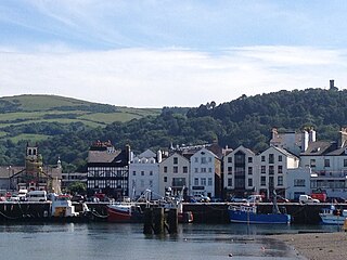
Ramsey is a coastal town in the north of the Isle of Man. It is the second largest town on the island after Douglas. Its population is 7,845 according to the 2016 Census. It has one of the biggest harbours on the island, and has a prominent derelict pier, called the Queen's Pier. It was formerly one of the main points of communication with Scotland. Ramsey has also been a route for several invasions by the Vikings and Scots.

<span class="mw-page-title-main">Luing</span>

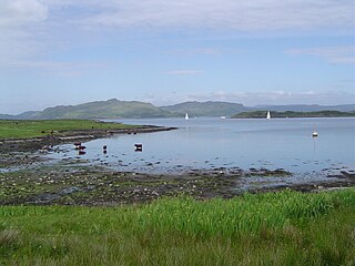
Luing is one of the Slate Islands, Firth of Lorn, in the west of Argyll in Scotland, about 16 miles (26 km) south of Oban. The island has an area of 1,430 hectares and is bounded by several small skerries and islets. It has a population of around 200 people, mostly living in Cullipool, Toberonochy, and Blackmillbay.

St John's is a small village in the sheading of Glenfaba in the Isle of Man, in the island's central valley. It is in the House of Keys constituency of Glenfaba & Peel, which elects two MHKs.

<span class="mw-page-title-main">Geology of Scotland</span> Overview of the geology of Scotland

The geology of Scotland is unusually varied for a country of its size, with a large number of different geological features. There are three main geographical sub-divisions: the Highlands and Islands is a diverse area which lies to the north and west of the Highland Boundary Fault; the Central Lowlands is a rift valley mainly comprising Palaeozoic formations; and the Southern Uplands, which lie south of the Southern Uplands Fault, are largely composed of Silurian deposits.

<span class="mw-page-title-main">Patrick (parish)</span> Human settlement in the United Kingdom

Patrick is one of the seventeen historic parishes of the Isle of Man.

Cammag is a team sport originating on the Isle of Man. It is closely related to the Scottish game of shinty and the Irish game of hurling. Once the most widespread sport on Mann, it ceased to be played in the early twentieth century after the introduction of association football and is no longer an organised sport.

<span class="mw-page-title-main">Hills and mountains of the Isle of Man</span>

The Isle of Man is mostly hilly, but has only one summit, Snaefell, classified as a mountain.

<span class="mw-page-title-main">Geology of the Isle of Skye</span>

The geology of the Isle of Skye in Scotland is highly varied and the island's landscape reflects changes in the underlying nature of the rocks. A wide range of rock types are exposed on the island, sedimentary, metamorphic and igneous, ranging in age from the Archaean through to the Quaternary.

The geology of County Durham in northeast England consists of a basement of Lower Palaeozoic rocks overlain by a varying thickness of Carboniferous and Permo-Triassic sedimentary rocks which dip generally eastwards towards the North Sea. These have been intruded by a pluton, sills and dykes at various times from the Devonian Period to the Palaeogene. The whole is overlain by a suite of unconsolidated deposits of Quaternary age arising from glaciation and from other processes operating during the post-glacial period to the present. The geological interest of the west of the county was recognised by the designation in 2003 of the North Pennines Area of Outstanding Natural Beauty as a European Geopark.

The geology of Tyne and Wear in northeast England largely consists of a suite of sedimentary rocks dating from the Carboniferous and Permian periods into which were intruded igneous dykes during the later Palaeogene Period.

The Great Scar Limestone Group is a lithostratigraphical term referring to a succession of generally fossiliferous rock strata which occur in the Pennines in northern England and in the Isle of Man within the Tournaisian and Visean stages of the Carboniferous Period.

The geology of Northumberland in northeast England includes a mix of sedimentary, intrusive and extrusive igneous rocks from the Palaeozoic and Cenozoic eras. Devonian age volcanic rocks and a granite pluton form the Cheviot massif. The geology of the rest of the county is characterised largely by a thick sequence of sedimentary rocks of Carboniferous age. These are intruded by both Permian and Palaeogene dykes and sills and the whole is overlain by unconsolidated sediments from the last ice age and the post-glacial period. The Whin Sill makes a significant impact on Northumberland's character and the former working of the Northumberland Coalfield significantly influenced the development of the county's economy. The county's geology contributes to a series of significant landscape features around which the Northumberland National Park was designated.

<span class="mw-page-title-main">Foxdale Mines</span> Historic network of mines and shafts on the Isle of Man

The Foxdale Mines is a collective term for a series of mines and shafts which were situated in a highly mineralised zone on the Isle of Man, running east to west, from Elerslie mine in Crosby to Niarbyl on the coast near Dalby. In the 19th century the mines were widely regarded as amongst the richest ore mines in the British Isles.

The Manx Group is an Ordovician lithostratigraphic group in the Isle of Man in the Irish Sea. The name is derived from the name of the island which is largely formed from them; these rocks have also previously been referred to as the Manx Slates or Manx Slates Series. The group comprises dark mudstones with siltstone laminae and some sandstones and which exceed a thickness of 3000m. It is divided into a lowermost Glen Dhoo Formation which is overlain by the Lonan, Mull Hill, Creg Agneash and Maughold formations in ascending order. A fault separates these from the overlying Barrule, Injebreck, Glen Rushen and Creggan Mooar formations which are in turn separated by a fault from an overlying Ladyport Formation.

The Dalby Group is a Silurian lithostratigraphic group on the west coast of the Isle of Man in the Irish Sea. The name is derived from the village of Dalby near the west coast of the island. Together with those of the adjoining Manx Group, the rocks of the Group have also previously been referred to as the Manx Slates or Manx Slate Series. The group comprises wacke sandstones with siltstones and mudstones which reach a thickness of about 1200m in the west of the island. It contains only the single Niarbyl Formation which is exposed along the coast between Niarbyl Point and the town of Peel to the north.

The geology of Northumberland National Park in northeast England includes a mix of sedimentary, intrusive and extrusive igneous rocks from the Palaeozoic and Cenozoic eras. Devonian age volcanic rocks and a granite pluton form the Cheviot massif. The geology of the rest of the national park is characterised largely by a thick sequence of sedimentary rocks of Carboniferous age. These are intruded by Permian dykes and sills, of which the Whin Sill makes a significant impact in the south of the park. Further dykes were intruded during the Palaeogene period. The whole is overlain by unconsolidated sediments from the last ice age and the post-glacial period.

<span class="mw-page-title-main">Geology of the Isle of Mull</span>

The geology of the Isle of Mull in Scotland is dominated by the development during the early Palaeogene period of a ‘volcanic central complex’ associated with the opening of the Atlantic Ocean. The bedrock of the larger part of the island is formed by basalt lava flows ascribed to the Mull Lava Group erupted onto a succession of Mesozoic sedimentary rocks during the Palaeocene epoch. Precambrian and Palaeozoic rocks occur at the island's margins. A number of distinct deposits and features such as raised beaches were formed during the Quaternary period.

The geology of Anglesey, the largest (714 km2) island in Wales is some of the most complex in the country. Anglesey has relatively low relief, the 'grain' of which runs northeast–southwest, i.e. ridge and valley features extend in that direction reflecting not only the trend of the late Precambrian and Palaeozoic age bedrock geology but also the direction in which glacial ice traversed and scoured the island during the last ice age. It was realised in the 1980s that the island is composed of multiple terranes, recognition of which is key to understanding its Precambrian and lower Palaeozoic evolution. The interpretation of the island's geological complexity has been debated amongst geologists for decades and recent research continues in that vein.

The geology of the Yorkshire Dales National Park in northern England largely consists of a sequence of sedimentary rocks of Ordovician to Permian age. The core area of the Yorkshire Dales is formed from a layer-cake of limestones, sandstones and mudstones laid down during the Carboniferous period. It is noted for its karst landscape which includes extensive areas of limestone pavement and large numbers of caves including Britain's longest cave network.

References

  1. "Coastal and offshore geology report" (PDF). Isle of Man Government. Retrieved 22 January 2019.
  2. Stone, P; Millward, D; Young, B; Merritt, J W; Clarke, S M; McCormac, M; Lawrence, D J D (2010). British Regional Geology: Northern England. British Geological Survey, NERC. p. 24. ISBN   9780852726525.
  3. Stone, P; Millward, D; Young, B; Merritt, J W; Clarke, S M; McCormac, M; Lawrence, D J D (2010). British Regional Geology: Northern England. British Geological Survey, NERC. p. 250. ISBN   9780852726525.
  4. "Coastal and offshore Geology report" (PDF). Isle of Man Government. Retrieved 22 January 2019.
  5. Stone, P; Millward, D; Young, B; Merritt, J W; Clarke, S M; McCormac, M; Lawrence, D J D (2010). British Regional Geology: Northern England. British Geological Survey, NERC. p. 100. ISBN   9780852726525.
  6. Stone, P; Millward, D; Young, B; Merritt, J W; Clarke, S M; McCormac, M; Lawrence, D J D (2010). British Regional Geology: Northern England. British Geological Survey, NERC. p. 101. ISBN   9780852726525.
  7. "Coastal and offshore geology report" (PDF). Isle of Man Government. Retrieved 22 January 2019.
  8. Isle of Man solid and drift geology, 1:50,000 scale. British Geological Survey, NERC. 2001. ISBN   0751833266.
  9. Stone, P; Millward, D; Young, B; Merritt, J W; Clarke, S M; McCormac, M; Lawrence, D J D (2010). British Regional Geology: Northern England. British Geological Survey, NERC. p. 186. ISBN   9780852726525.
  10. Stone, P; Millward, D; Young, B; Merritt, J W; Clarke, S M; McCormac, M; Lawrence, D J D (2010). British Regional Geology: Northern England. British Geological Survey, NERC. pp. 89–91. ISBN   9780852726525.
  11. The Geological Society (2006). Brenchley, P.J. (ed.). The Geology of England (2. ed.). London: Geological Society Publishing. pp. 136–137. ISBN   9781862392007.
  12. Stone, P; Millward, D; Young, B; Merritt, J W; Clarke, S M; McCormac, M; Lawrence, D J D (2010). British Regional Geology: Northern England. British Geological Survey, NERC. pp. 199–200. ISBN   9780852726525.
  13. Stone, P; Millward, D; Young, B; Merritt, J W; Clarke, S M; McCormac, M; Lawrence, D J D (2010). British Regional Geology: Northern England. British Geological Survey, NERC. p. 247. ISBN   9780852726525.
  14. Stone, P; Millward, D; Young, B; Merritt, J W; Clarke, S M; McCormac, M; Lawrence, D J D (2010). British Regional Geology: Northern England. British Geological Survey, NERC. p. 248. ISBN   9780852726525.
  15. Stone, P; Millward, D; Young, B; Merritt, J W; Clarke, S M; McCormac, M; Lawrence, D J D (2010). British Regional Geology: Northern England. British Geological Survey, NERC. p. 220. ISBN   9780852726525.
  16. "Glacial sediments". Manx Geological Survey. Retrieved 22 January 2019.
  17. Stone, P; Millward, D; Young, B; Merritt, J W; Clarke, S M; McCormac, M; Lawrence, D J D (2010). British Regional Geology: Northern England. British Geological Survey, NERC. pp. 212, 218. ISBN   9780852726525.
  18. "Coastal and offshore geology report" (PDF). Isle of Man Government. Retrieved 22 January 2019.