Glen Head, New York

Last updated
Glen Head, New York
Downtown Glen Head, Long Island, New York August 29, 2021.jpg
Downtown Glen Head on August 29, 2021.
Nassau County New York incorporated and unincorporated areas Glen Head highlighted.svg
Location in Nassau County and the state of New York.
USA New York location map.svg
Red pog.svg
Glen Head, New York
Location within the state of New York.
Coordinates: 40°50′26″N73°37′8″W / 40.84056°N 73.61889°W / 40.84056; -73.61889 Coordinates: 40°50′26″N73°37′8″W / 40.84056°N 73.61889°W / 40.84056; -73.61889
Country Flag of the United States.svg  United States
State Flag of New York.svg  New York
County Flag of Nassau County, New York.svg  Nassau County, New York
Town Oyster Bay
Area
[1]
  Total1.64 sq mi (4.25 km2)
  Land1.64 sq mi (4.25 km2)
  Water0.00 sq mi (0.00 km2)
Elevation
115 ft (35 m)
Population
 (2020)
  Total4,837
  Density2,944.00/sq mi (1,136.89/km2)
Time zone UTC-5 (Eastern (EST))
  Summer (DST) UTC-4 (EDT)
ZIP code
11545
Area code 516
FIPS code 36-29245
GNIS feature ID0951181
NWS SAME code 036059

Glen Head is a hamlet and census-designated place (CDP) located within the Town of Oyster Bay in Nassau County, on the North Shore of Long Island, in New York, United States. It is considered part of the greater Glen Cove area, which is anchored by the City of Glen Cove. The population was 4,837 at the 2020 census.

Contents

Glen Head residents attend the award winning North Shore Central School District.

The Strat-O-Matic game company is headquartered in Glen Head.

Geography

U.S. Census map of Glen Head. Glen-head-ny-map.gif
U.S. Census map of Glen Head.
Gold Coast Public Library in Glen Head Gold Coast Public Library 2016.JPG
Gold Coast Public Library in Glen Head

According to the United States Census Bureau, the CDP has a total area of 1.6 square miles (4.1 km2), all land. [2]

Glen Head has transportation connections via its bus line (N27) and its rail line Long Island Rail Road to New York City and three major roads: Glen Cove Road, Glen Head Road, and Glen Cove Avenue. [3]

Demographics

Historical population
CensusPop.Note
2020 4,837
U.S. Decennial Census [4]

2010 census

As of the 2010 census [5] the population of the Census designated place was 4,697. The population was 91.8% White 86.2% Non-Hispanic white, 0.9% Black or African American, 0.1% Native American, 3.4% Asian, 0.0% Pacific Islander, 2.3% from other races, and 1.5% from two or more races. Hispanic or Latino of any race were 8.1% of the population.

2000 census

As of the census [5] of 2000, there were 4,625 people, 1,681 households, and 1,314 families residing in the CDP. The population density was 2,870.7 per square mile (1,109.1/km2). There were 1,717 housing units at an average density of 1,065.7/sq mi (411.8/km2). The racial makeup of the CDP was 95.29% White, 0.50% African American, 0.04% Native American, 2.01% Asian, 0.06% Pacific Islander, 1.15% from other races, and 0.95% from two or more races. Hispanic or Latino of any race were 4.61% of the population.

There were 1,681 households, out of which 34.0% had children under the age of 18 living with them, 65.0% were married couples living together, 9.8% had a female householder with no husband present, and 21.8% were non-families. 18.0% of all households were made up of individuals, and 9.0% had someone living alone who was 65 years of age or older. The average household size was 2.75 and the average family size was 3.12.

In the CDP, the population was spread out, with 23.9% under the age of 18, 5.3% from 18 to 24, 26.9% from 25 to 44, 27.1% from 45 to 64, and 16.9% who were 65 years of age or older. The median age was 42 years. For every 100 females, there were 81.1 males. For every 100 females age 18 and over, there were 79.3 males.

The median income for a household in the CDP was $94,453, and the median income for a family was $103,048. Males had a median income of $86,469 versus $50,909 for females. The per capita income for the CDP was $67,425. About 1.4% of families and 2.4% of the population were below the poverty line, including 2.2% of those under age 18 and 1.4% of those age 65 or over.

Related Research Articles

<span class="mw-page-title-main">Theodore, Alabama</span> Census-designated place in Alabama, United States

Theodore is an unincorporated area and census-designated place (CDP) in Mobile County, Alabama, United States. The population was 6,270 at the 2020 census. It is a part of the Mobile metropolitan area. Prior to 1900 this area was known as "Clements", but it is now named for William Theodore Hieronymous, a sawmill operator and postmaster.

<span class="mw-page-title-main">South Taft, California</span> Census-designated place in California, United States

South Taft is a census-designated place (CDP) in Kern County, California, United States. South Taft is located 0.5 miles (0.8 km) south of Taft, at an elevation of 1,017 feet (310 m). The population was 2,169 at the 2010 census, up from 1,898 at the time of the 2000 census.

<span class="mw-page-title-main">Lemon Cove, California</span> Census designated place in California, United States

Lemon Cove is a census-designated place (CDP) in the San Joaquin Valley in Tulare County, California, United States. The population was 308 at the 2010 census, up from 298 at the 2000 census.

<span class="mw-page-title-main">South Bradenton, Florida</span> Census-designated place in Florida, United States

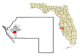
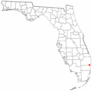
South Bradenton is an unincorporated community and census-designated place (CDP) in Manatee County, Florida, United States. The population was 26,858 at the 2020 census, up from 22,178 in 2010. It is part of the Bradenton–Sarasota–Venice Metropolitan Statistical Area.

<span class="mw-page-title-main">Hunter's Creek, Florida</span> Census-designated place in Florida, United States

Hunter's Creek is a master planned, unincorporated community and census-designated place in Orange County, Florida, United States. It is part of the Orlando–Kissimmee–Sanford, Florida Metropolitan Statistical Area. The population was 14,321 at the 2010 census. It has grown up around a large planned community named Hunter's Creek, though the CDP name given by the United States Census Bureau lacks the apostrophe.

<span class="mw-page-title-main">Sandalfoot Cove, Florida</span> Unincorporated place in Florida, United States

Sandalfoot Cove was a census-designated place (CDP) located in an unincorporated area near Boca Raton in Palm Beach County, Florida, United States. The population was 16,582 at the 2000 census. While it is not officially in the City of Boca Raton, the community is frequently classified under its umbrella term.

<span class="mw-page-title-main">Makawao, Hawaii</span> Census-designated place in Hawaii, United States

Makawao is a census-designated place (CDP) in Maui County, Hawaiʻi, United States. The population was 7,297 at the 2020 census. Located on the rural northwest slope of Haleakala on East Maui, the community is known for being the hub of the "Upcountry", a part of the island dominated by mostly agriculture and ranch land. Makawao Forest Reserve is to the east-northeast.

<span class="mw-page-title-main">Preston Heights, Illinois</span> Census-designated place in Illinois, United States

Preston Heights is a census-designated place (CDP) in Will County, Illinois, United States. As of the 2020 census, the CDP population was 2,898.

<span class="mw-page-title-main">Lochearn, Maryland</span> Census-designated place in Maryland, United States

Lochearn is an unincorporated community and census-designated place in Baltimore County, Maryland, United States, located immediately to the west of the City of Baltimore. Per the 2020 census, the population was 25,511.

<span class="mw-page-title-main">Fairland, Maryland</span> Census-designated place in Maryland, United States

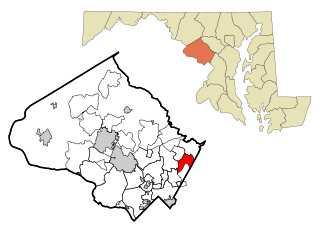
Fairland is a census-designated place and an unincorporated area in Montgomery County, Maryland, United States. It had a population of 25,396 per the 2020 census.

<span class="mw-page-title-main">Beckett, New Jersey</span> Census-designated place in New Jersey, United States

Beckett is an unincorporated community and census-designated place (CDP) within Logan Township, in Gloucester County, New Jersey, United States. As of the 2010 United States Census, the CDP's population was 4,847.

<span class="mw-page-title-main">Cedar Glen Lakes, New Jersey</span> Census-designated place in New Jersey, United States

Cedar Glen Lakes is an unincorporated community and census-designated place (CDP) located within Manchester Township, in Ocean County, New Jersey, United States. As of the 2010 United States Census, the CDP's population was 1,421.

<span class="mw-page-title-main">Cedar Glen West, New Jersey</span> Census-designated place in New Jersey, United States

Cedar Glen West is an unincorporated community and census-designated place (CDP) located within Manchester Township, in Ocean County, New Jersey, United States. As of the 2010 United States Census, the CDP's population was 1,267.

<span class="mw-page-title-main">Glenwood Landing, New York</span> Hamlet and census-designated place in New York, United States

Glenwood Landing is a hamlet and census-designated place (CDP) in Nassau County, New York. The population was 3,779 at the time of the 2010 census.

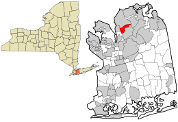
Glens Falls North is a census-designated place (CDP) in Warren County, New York, United States. It is part of the Glens Falls Metropolitan Statistical Area. The CDP population was 8,061 at the 2000 census. It lies north of the city of Glens Falls, in the town of Queensbury.

Maple Glen is a census-designated place (CDP) in Montgomery County, Pennsylvania, United States. The population was 6,647 at the 2020 census.

<span class="mw-page-title-main">Cove, Utah</span> Census-designated place in Utah, United States

Cove is a census-designated place (CDP) in Cache County, Utah, United States. The population was 460 at the 2010 census. It is included in the Logan, Utah-Idaho Metropolitan Statistical Area.

<span class="mw-page-title-main">Wilbraham (CDP), Massachusetts</span> Census-designated place in Massachusetts, United States

Wilbraham is a census-designated place (CDP) in the town of Wilbraham in Hampden County, Massachusetts, United States. The population was 3,915 at the 2010 census, out of 14,868 in the town as a whole. It is part of the Springfield, Massachusetts Metropolitan Statistical Area.

Bar Harbor is a census-designated place (CDP) in the town of Bar Harbor in Hancock County, Maine, United States. The CDP population was 2,552 at the 2010 census, out of a population of 5,235 in the town of Bar Harbor as a whole.

<span class="mw-page-title-main">Boothbay Harbor (CDP), Maine</span> Census-designated place in Maine, United States

Boothbay Harbor is a census-designated place (CDP) comprising the densely populated center of the town of Boothbay Harbor in Lincoln County, Maine, United States. The population was 1,086 at the 2010 census, down from 1,237 at the 2000 census.

References

  1. "ArcGIS REST Services Directory". United States Census Bureau. Retrieved September 20, 2022.
  2. "US Gazetteer files: 2010, 2000, and 1990". United States Census Bureau. 2011-02-12. Retrieved 2011-04-23.
  3. "Long Island Index: Interactive Map". www.longislandindexmaps.org. Retrieved 2021-08-26.
  4. "Census of Population and Housing". Census.gov. Retrieved June 4, 2016.
  5. 1 2 "U.S. Census website". United States Census Bureau . Retrieved March 29, 2014.