South Farmingdale, New York

Last updated

South Farmingdale, New York
Willard Avenue, South Farmingdale, Long Island, New York July 4, 2021.jpg
Willard Avenue in South Farmingdale on July 4, 2021.
Nassau County New York incorporated and unincorporated areas South Farmingdale highlighted.svg
Location in Nassau County and the state of New York.
Location map Long Island.png
Red pog.svg
Location on Long Island
USA New York location map.svg
Red pog.svg
Location within the state of New York
Coordinates: 40°43′6″N73°26′44″W / 40.71833°N 73.44556°W / 40.71833; -73.44556
Country Flag of the United States.svg  United States
State Flag of New York.svg  New York
County Nassau
Town Oyster Bay
Named for Its location south of Farmingdale
Area
[1]
  Total2.20 sq mi (5.69 km2)
  Land2.19 sq mi (5.68 km2)
  Water0.00 sq mi (0.01 km2)
Elevation
59 ft (18 m)
Population
 (2020)
  Total14,345
  Density6,541.27/sq mi (2,525.83/km2)
Time zone UTC-5 (Eastern (EST))
  Summer (DST) UTC-4 (EDT)
ZIP code
11735
Area codes 516, 363
FIPS code 36-69001
GNIS feature ID0965744

South Farmingdale is a hamlet and census-designated place (CDP) in the Town of Oyster Bay in Nassau County, on the South Shore of Long Island, in New York, United States. It is considered part of the Greater Farmingdale area, which is anchored by Farmingdale. [2] The population of the CDP was 14,345 at the 2020 census. [3]

Contents

History

South Farmingdale's name reflects its geographic location immediately south of and adjacent to the Incorporated Village of Farmingdale. [4]

A railroad station named South Farmingdale previously existed in the hamlet on the Central Branch of the Long Island Rail Road. [5] It had originally opened in 1873 and closed in 1898, and then reopened in 1936 and closed for the final time in 1972. [5] [6]

Geography

U.S. Census map of South Farmingdale. South-farmingdale-ny-map.gif
U.S. Census map of South Farmingdale.

According to the United States Census Bureau, South Farmingdale has a total area of 2.2 square miles (5.7 km2), all land. [7]

The CDP gained territory between the 1990 census and the 2000 census. [8]

Topography and drainage

South Farmingdale is located on a flat outwash plain, and as such, the hamlet's topography is largely flat. [9] [10] Additionally, South Farmingdale is split between the Massapequa Creek and Seaford Creek drainage areas, and is located within the larger Long Island Sound/Atlantic Ocean Watershed. [9] [10] [11]

Postal services

Residents of South Farmingdale have a ZIP code of 11735. They are served by the Farmingdale Post Office, located at 918 Main Street, Farmingdale, NY 11735-5426. While residents can and do typically use Farmingdale as their postal address, the post office also accepts mail that is addressed to South Farmingdale. [12]

Demographics

Historical population
CensusPop.Note
2000 15,061
2010 14,486−3.8%
2020 14,345−1.0%
U.S. Decennial Census [13]

2020 census

At the time of the 2020 census, there were 14,345 people residing in the hamlet. [14]

2010 census

At the time of the 2010 census, there were 14,486 people residing in the CDP. The racial makeup of the CDP was 90.1% White 83% Non-Hispanic White, 1.4% African American, 0.1% Native American, 4.5% Asian, 0.0% Pacific Islander, 2.2% from other races, and 1.7% from two or more races. Hispanics or Latinos of any race were 10% of the population. [14]

2000 census

At the time of the 2000 census, there were 15,061 people 4,899 households, and 4,095 families residing in the CDP. The population density was 6,886.0 inhabitants per square mile (2,658.7/km2). There were 4,950 housing units at an average density of 2,263.2 per square mile (873.8/km2). The racial makeup of the CDP was 93.01% White, 0.79% African American, 0.08% Native American, 3.18% Asian, 0.03% Pacific Islander, 1.85% from other races, and 1.07% from two or more races. Hispanic or Latino of any race were 5.90% of the population. [15]

There were 4,899 households, of which 36.3% had children under the age of 18 living with them, 69.9% were married couples living together, 10.5% had a female householder with no husband present, and 16.4% were non-families. 13.5% of all households were made up of individuals, and 7.2% had someone living alone who was 65 years of age or older. The average household size was 3.07 and the average family size was 3.37.

Age distribution was 25.1% under the age of 18, 6.2% from 18 to 24, 30.8% from 25 to 44, 21.7% from 45 to 64, and 16.2% who were 65 years of age or older. The median age was 38 years. For every 100 females, there were 96.5 males. For every 100 females age 18 and over, there were 91.0 males.

The median household income was $71,168, and the median family income was $76,049. Males had a median income of $52,290 versus $36,475 for females. The per capita income for the CDP was $25,927. About 2.5% of families and 2.8% of the population were below the poverty line, including 4.4% of those under age 18 and 2.9% of those age 65 or over.

Education

Schools

South Farmingdale is served by the Farmingdale Union Free School District. [16]

The district includes Farmingdale High School, Howitt Middle School, Northside Elementary School, Woodward Parkway School, Albany Avenue Elementary School in North Massepequa, and Saltzman East Memorial in Suffolk County. [16]

Library district

South Farmingdale is located within the boundaries of the Farmingdale Library District, which is served by the Farmingdale Public Library. [16]

Furthermore, the Farmingdale Public Library is located within the hamlet, at 116 Merritts Road. [16]

Parks and recreation

An entrance to Ellsworth W. Allen Town Park in 2021. Ellsworth W. Allen Town Park, South Farmingdale, Long Island, New York July 4, 2021.jpg
An entrance to Ellsworth W. Allen Town Park in 2021.

South Farmingdale is home to Ellsworth W. Allen Town Park, which is owned and operated by the Town of Oyster Bay. [17] The park has an area of approximately 15.8 acres (6.4 ha) and includes a playground, several athletic fields, a spray park, and areas for picnicking. [17]

Infrastructure

Transportation

Road

Major roads in South Farmingdale include Merritts Road, Motor Avenue, and the Southern State Parkway. [16]

Rail

The LIRR's Central Branch within South Farmingdale, at the site of the former, eponymous station in 2014. Former South Farmingdale LIRR Station Site.JPG
The LIRR's Central Branch within South Farmingdale, at the site of the former, eponymous station in 2014.

No Long Island Rail Road stations are located within the hamlet – although the LIRR's Central Branch forms its northern border. [16] The nearest stations to the hamlet are Farmingdale on the Ronkonkoma Branch and Massapequa Park on the Babylon Branch. [16]

Additionally, the now-closed South Farmingdale station was once located on the Central Branch, within the hamlet; it closed in the 1970s. [5] It was along this stretch of the Central Branch that Mile-a-Minute Murphy set a record in 1899, pedaling a bicycle for one mile behind a train in less than one minute. [5]

Utilities

Natural gas

National Grid USA provides natural gas to homes and businesses that are hooked up to natural gas lines in South Farmingdale. [18] [19]

Power

PSEG Long Island provides power to all homes and businesses within South Farmingdale. [18] [20]

Sewage

South Farmingdale is located within the Nassau County Sewage District and is connected to its sanitary sewer network. [16] [21]

Water

South Farmingdale is located with the boundaries of (and is thus served by) the South Farmingdale Water District, which has provided service to the area since 1931. [16]

Emergency services

Fire

South Farmingdale is primarily within the boundaries of (and is thus served by) the South Farmingdale Fire District. [16] The district's main firehouse is located at 819 Main Street, while a second station is at the corner of Merrits Rd and Beverly Road. [22] A small portion of the hamlet, meanwhile, is located within the boundaries of (and is thus served by) the North Massapequa Fire District. [16]

Police

South Farmingdale is served by the Nassau County Police Department's 8th Precinct, with RMPs 816 and 817 assigned as the patrol cars for the hamlet. [16] [23] [24] [25]

Related Research Articles

<span class="mw-page-title-main">Nassau County, New York</span> County in New York, United States

Nassau County is an affluent inner suburban county located on Long Island, immediately to the east of New York City. As of the 2020 United States census, Nassau County's population was 1,395,774, making it the sixth-most populous county in New York State, and reflecting an increase of 56,242 (+4.2%) from the 1,339,532 residents enumerated at the 2010 census. Its county seat is Mineola, while the county's largest town is Hempstead.

<span class="mw-page-title-main">Albertson, New York</span> Hamlet and census-designated place in New York, United States

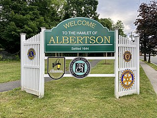
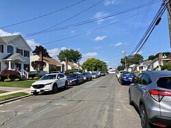
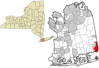
Albertson is a hamlet and census-designated place (CDP) in the Town of North Hempstead in Nassau County, on Long Island, in New York, United States. The population was 5,182 at the 2010 census.

<span class="mw-page-title-main">Bay Park, New York</span> Hamlet and census-designated place in New York, United States

Bay Park is a hamlet and census-designated place (CDP) in the Town of Hempstead in Nassau County, on the South Shore of Long Island, in New York, United States. The population was 2,212 at the 2010 census.

<span class="mw-page-title-main">East Massapequa, New York</span> Hamlet and census-designated place in New York, United States

East Massapequa is a hamlet and census-designated place (CDP) located within the Town of Oyster Bay in Nassau County, on the South Shore of Long Island, in New York, United States. The population was 19,069 at the 2010 census.

<span class="mw-page-title-main">Farmingdale, New York</span> Village in New York, United States

Farmingdale is an incorporated village on Long Island within the Town of Oyster Bay in Nassau County, New York, United States. The population was 8,466 at the time of the 2020 Census.

<span class="mw-page-title-main">Greenvale, New York</span> Hamlet and census-designated place in New York, United States

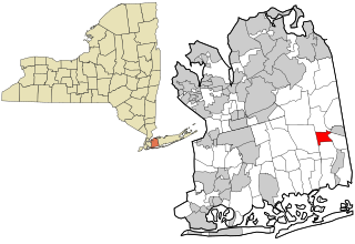
Greenvale is a hamlet and census-designated place (CDP) in the towns of North Hempstead and Oyster Bay in Nassau County, on the North Shore of Long Island, in New York, United States. It is considered part of the Greater Roslyn area, which is anchored by the Incorporated Village of Roslyn. The population was 1,069 at the time of the 2020 census.

<span class="mw-page-title-main">Herricks, New York</span> Hamlet and census-designated place in New York, United States

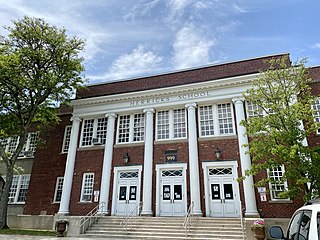
Herricks is a hamlet and census-designated place (CDP) in Nassau County, on Long Island, in New York, United States. The population was 4,398 at the 2020 census.

<span class="mw-page-title-main">Manhasset Hills, New York</span> Hamlet and census-designated place in New York, United States

Manhasset Hills is a hamlet and census-designated place (CDP) in the Town of North Hempstead in Nassau County, on Long Island, in New York, United States. The population was 3,592 at the 2010 census. Neighboring communities include Herricks, North Hills, North New Hyde Park, and Lake Success.

<span class="mw-page-title-main">Massapequa, New York</span> Hamlet and census-designated place in New York, United States

Massapequa is a hamlet and census-designated place (CDP) in the Town of Oyster Bay in Nassau County, on the South Shore of Long Island, in New York, United States. It is considered the anchor community of the Greater Massapequa area. The population of the CDP was 21,685 at the time of the 2010 census.

<span class="mw-page-title-main">Massapequa Park, New York</span> Village in New York, United States

Massapequa Park is an incorporated village located within the southern portion of the Town of Oyster Bay in Nassau County, on the South Shore of Long Island, in New York. The population was 17,008 at the 2010 census.

<span class="mw-page-title-main">North Massapequa, New York</span> Hamlet and census-designated place in New York, United States

North Massapequa is a hamlet and census-designated place (CDP) located on Long Island within the Town of Oyster Bay in Nassau County, on Long Island, in New York, United States. It is considered part of the Greater Massapequa area, which is anchored by Massapequa. The population was 17,886 at the 2010 census.

<span class="mw-page-title-main">North Valley Stream, New York</span> Hamlet and Census-designated place in New York, United States

North Valley Stream is a hamlet and census-designated place (CDP) in the Town of Hempstead in Nassau County, on Long Island, in New York, United States. The population was 16,628 at the 2010 census.

<span class="mw-page-title-main">Old Bethpage, New York</span> Hamlet and census-designated place in New York, United States

Old Bethpage is a hamlet and census-designated place (CDP) located on Long Island in the Town of Oyster Bay, Nassau County, New York, United States. The population of the CDP was 5,283 at the 2020 United States Census. It is served by the Old Bethpage Post Office, ZIP code 11804.

<span class="mw-page-title-main">Plainedge, New York</span> Hamlet and census-designated place in New York, United States

Plainedge is a hamlet and census-designated place (CDP) in the Town of Oyster Bay in Nassau County, on Long Island, in New York, United States. The population was 8,817 at the 2010 census.

<span class="mw-page-title-main">Port Washington, New York</span> Hamlet and census-designated place in North Hempstead, Nassau County, New York, United States

Port Washington is a hamlet and census-designated place (CDP) on the Cow Neck Peninsula in the Town of North Hempstead, in Nassau County, on the North Shore of Long Island, in New York. The hamlet is the anchor community of the Greater Port Washington area. The population was 16,753 at the 2020 census.

<span class="mw-page-title-main">Roslyn Heights, New York</span> Hamlet and census-designated place in New York, United States

Roslyn Heights is a hamlet and census-designated place (CDP) in the Town of North Hempstead in Nassau County, on Long Island, in New York, United States. It is considered part of the Greater Roslyn area, which is anchored by the Incorporated Village of Roslyn. The population was 6,577 at the 2010 census.

<span class="mw-page-title-main">University Gardens, New York</span> Hamlet and census-designated place in New York, United States

University Gardens is a hamlet and a census-designated place (CDP) in Nassau County, on the North Shore of Long Island, in New York, United States. It is located within the Town of North Hempstead and is part of the Greater Great Neck area. The population was 4,358 at the time of the 2020 census.

<span class="mw-page-title-main">East Farmingdale, New York</span> Hamlet and census-designated place in New York, United States

East Farmingdale is a hamlet and a census-designated place (CDP) in Suffolk County, on Long Island, in New York. The population of the CDP was 6,484 at the 2010 census. Located in the Town of Babylon, the residents are served by the Farmingdale Post Office.

<span class="mw-page-title-main">North Amityville, New York</span> Hamlet and Census-designated place in New York, United States

North Amityville is a hamlet and census-designated place (CDP) in the Town of Babylon in Suffolk County, on the South Shore of Long Island, in New York. The population was 18,643 at the 2020 Census.

<span class="mw-page-title-main">Oyster Bay, New York</span> Town in New York, United States

The Town of Oyster Bay is the easternmost of the three towns which make up Nassau County, New York, United States. Part of the New York metropolitan area, it is the only town in Nassau County to extend from the North Shore to the South Shore of Long Island. As of the 2020 census, it had a population of 301,332.

References

  1. "ArcGIS REST Services Directory". United States Census Bureau. Retrieved September 20, 2022.
  2. Road signs erected by the county at the southeast corner of the CDP (along Main Street, about a mile from the Village of Farmingdale) welcome travelers to Farmingdale.
  3. "Profile of General Population and Housing Characteristics: 2010 for South Farmingdale, CDP, New York".
  4. Winsche, Richard (October 1, 1999). The History of Nassau County Community Place-Names. Interlaken, New York: Empire State Books. ISBN   978-1557871541.
  5. 1 2 3 4 Seyfried, Vincent; Emery, Robert; Huneke, Art; Erlitz, Jeff. "LONG ISLAND RAIL ROAD Alphabetical Station Listing and History" (PDF). trainsarefun.com. Retrieved November 24, 2017.
  6. Perlmutter, Emanuel (June 18, 1972). "L.I.R.R. Improving Service on All Lines Under a New Timetable". The New York Times. ISSN   0362-4331 . Retrieved May 4, 2018.
  7. "US Gazetteer files: 2010, 2000, and 1990". United States Census Bureau. February 12, 2011. Retrieved April 23, 2011.
  8. "New York: 2000 Population and Housing Unit Counts" (PDF). September 2003. p. III-10. Retrieved December 22, 2010.
  9. 1 2 New York Rapid Watershed Assessment Profile – Northern Long Island Watershed. Syracuse, New York: United States Department of Agriculture Natural Resources Conservation Service. 2011.
  10. 1 2 "EPA – Waters GeoViewer". United States Environmental Protection Agency . Retrieved July 28, 2021.{{cite web}}: CS1 maint: url-status (link)
  11. "Atlantic Ocean/Long Island Sound Watershed - NYS Dept. of Environmental Conservation". www.dec.ny.gov. Retrieved July 27, 2021.
  12. "ZIP Code Lookup". Enter 11735 in field for results.
  13. "Census of Population and Housing". Census.gov. Retrieved June 4, 2016.
  14. 1 2 Bureau, U. S. Census. "American FactFinder". wayback.archive-it.org. Retrieved July 16, 2023.
  15. "US 2000 Census data for CDP of South Farmingdale, NY". Archived from the original on February 10, 2020. Retrieved April 6, 2014.
  16. 1 2 3 4 5 6 7 8 9 10 11 12 "Long Island Index: Interactive Map". www.longislandindexmaps.org. Retrieved July 16, 2023.
  17. 1 2 "Town Parks – Town of Oyster Bay" . Retrieved July 16, 2023.
  18. 1 2 "Long Island Utility Information - LIPA, Nat Grid, & Local Water Authorities". LongIsland.com. Retrieved October 24, 2020.
  19. "Natural Gas & Electricity | National Grid". www.nationalgridus.com. Retrieved July 21, 2021.
  20. "Home Page - PSEG Long Island". www.psegliny.com. Retrieved July 21, 2021.
  21. "Sewerage Map – Nassau County". County of Nassau, New York. Retrieved August 5, 2021.{{cite web}}: CS1 maint: url-status (link)
  22. "South Farmingdale Fire Department".
  23. "County Map | Nassau County Police, NY". pdcn.org. Retrieved October 24, 2020.
  24. "Police Departments". nassaucountyny.gov. Retrieved December 20, 2020.
  25. "Quarterly Community Policing Report". www.pdcn.org. October 2016.