
Lumpkin County is a county located in the north central portion of the U.S. state of Georgia. As of the 2020 census, the population was 33,488. Its county seat is Dahlonega.

Fannin County is a county located in the north central portion of the U.S. state of Georgia. As of the 2020 census, the population was 25,319. It is one of the most rural counties in Georgia due its location in the Appalachian Mountain Range, with about 90% of the population of Fannin County living in unincorporated lands. The county seat is Blue Ridge. The county was created on January 21, 1854, and is named after James Fannin, a veteran who fought in the Texas Revolution.

Blue Ridge is a city in Fannin County, Georgia, United States. As of the 2020 census, the city had a population of 1,253. The city is the county seat of Fannin County.

Cohutta is a town in Whitfield County, Georgia, United States. It is part of the Dalton Metropolitan Statistical Area. The population was 764 at the 2020 census.
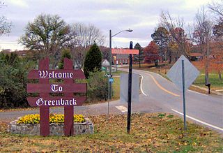
Greenback is a city in Loudon County, Tennessee, United States. Its population was at 1,102, according to the 2020 census. It is included in the Knoxville Metropolitan Statistical Area.

Copperhill is a city in Polk County, Tennessee, United States. The population was 443 at the 2020 census. It is included in the Cleveland Metropolitan Statistical Area.

Unorganized North Algoma District is an unorganized area in northeastern Ontario, Canada, comprising all areas in Algoma District, north of the Sault Ste. Marie to Elliot Lake corridor, which are not part of an incorporated municipality or a First Nation. It covers 44,077.03 km2 (17,018.24 sq mi) of land, and had a population of 6050 in 2021. Many of these communities were/are stations on the Algoma Central Railway or were logging/mining towns.

Ernest W. Barrett Parkway is a major thoroughfare in the northwestern part of the Atlanta metropolitan area, in the north-central part of Cobb County, in the U.S. state of Georgia. It travels from the southeastern edge of Kennesaw to a point north of Marietta, and continues on in both directions under other names. The portion of Barrett Parkway between Interstate 575 (I-575/SR 5) and US 41/SR 3 is designated State Route 5 Connector. The road is named after Ernest W. Barrett, the first chairman of the Cobb County Board of Commissioners in the 1960s, after home rule was enacted under a Georgia State Constitution amendment. The initial portion was constructed through Barrett family land, enabling it to be later sold for major development.

Powell, formerly known as Powell Station, is a census-designated place in Knox County, Tennessee. The area is located in the Emory Road corridor, just north of Knoxville, southeast of Clinton, and east of Oak Ridge. It had a population of 13,802 during the 2020 census. It is included in the Knoxville, TN Metropolitan Statistical Area.

Sixes, home to approximately 14,540, is an unincorporated community in western Cherokee County, Georgia, United States, located about three miles west of Holly Springs and near the eastern shore of current-day Lake Allatoona. The community is located in the Georgia Gold Belt, which runs southwest to northeast along the southern edge of the Blue Ridge mountains. The Sixes Gold Mine, a now-defunct gold mine dating back to the early 19th century, was located just to the northwest. In addition, the community is home to the Sixes Mill, which was originally built around 1820 by early gold prospectors and later rebuilt circa 1880. The mill has been well preserved and is still located off Sixes Road. There are two theories on how Sixes derived its name. The first theory attributes the name to Fort Hinar Sixes, a Cherokee Indian removal fort that was located in the area along the Trail of Tears. The second holds that the name is derived from an old Cherokee village that was located near the Etowah River named "Sutali" — the Cherokee word for the number six. Sixes also lent its name to Fort Sixes, an 1830s US Army fort that served as a removal collection point for Cherokee prior to the Trail of Tears. Sutallee, a community that sits on the opposite side of the Etowah River in western Cherokee County, also derives its name from this Native American village. Today, Sixes is a growing suburban community with many large, upscale residential neighborhoods, including BridgeMill. The area is served by two elementary schools ; one middle school (Freedom); and two high schools.

Sutallee is an unincorporated community in western Cherokee County, Georgia, United States. Located about two miles northwest of current-day Lake Allatoona, it is one of the county's earliest white settlements. It is believed that former Georgia Governor and U.S. Senator Joseph E. Brown maintained a farm in the area, on lowlands near the Etowah River, and was there harvesting wheat when told of the surprising news that he had been nominated for governor. Sutallee derives its unique name, which is often spelled "Sutalee" or "Suttallee", from an old Cherokee village that was located near the Etowah River named "Sutali" — the Cherokee word for the number six. Sixes, a community that sits on the eastern side of Lake Allatoona, also derives its name from this Native American village. Today, Sutallee is traversed by Georgia Highway 20 and remains mostly rural.

Hickory Flat is an unincorporated community in southeastern Cherokee County, Georgia, United States. It geographic center is now a triangle formed by GA 140 on the north and east, Hickory Rd on the south, and East Cherokee Drive on the west. This triangle is now the business hub of the community with two shopping centers anchored by grocery stores. It also contains the Hickory Flat Public Library and the Sequoyah High School educational complex which includes feeder schools; Hickory Flat Elementary and Dean Rusk Middle School.
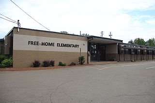
Free Home is an unincorporated community in the eastern part of Cherokee County, Georgia, United States. Centered at the intersection of state highways 20 and 372, the rural community has seen moderate suburbanization of the area since the late 1990s. It is home to Free Home Elementary School. The community is home to a Publix Supermarket center, which has a few stores/restaurants. There is also a Tractor Supply Company that was completed in September 2011.

The Little River is a 29.3-mile-long (47.2 km) tributary of the Etowah River in the U.S. state of Georgia in the United States.

Centered today at the crossroads of Georgia Highways 140 and 372, Crabapple, Georgia, is one of the oldest parts of Fulton County, Georgia. Originally part of Cherokee County, Georgia,, Crabapple was part of the land contributed in 1857 to form Milton County, Georgia. The first permanent settlement at Crabapple was made in 1874, with the community taking its name from a crabapple tree near the original town site. As a result of the Great Depression, Milton County was later absorbed into Fulton County in 1932. The historic heart of Crabapple is anchored by an historic brick building at the crossroads of Crabapple Road-Mayfield Road, Birmingham Road-Broadwell Road, and Mid-Broadwell Road. In 2006, a portion of Crabapple was one of several communities incorporated into the new city of Milton. Crabapple is now split between the cities of Milton, Roswell, and Alpharetta.
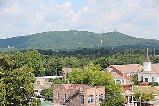
Sawnee Mountain is a low mountain between the piedmont and Appalachian foothills of the U.S. state of Georgia, north of Atlanta. Average rainfall/46.26in/yr/ average snowfall/5.7in/yr/. The name Sawnee Mountain actually refers to the entire ridge of approximately five miles (8 km) in length. At its summit, the elevation is 1,946 feet (593 m) above mean sea level, and is roughly 750 feet (230 m) above the surrounding terrain. The Sawnee Mountain range runs southwest to northeast, and consists of five knolls and three gaps. Located only a few miles north of Cumming, Georgia, the mountain is easily the highest point in Forsyth county. One of the highest peaks of metro Atlanta, it nudges out its prominently known neighbors Stone Mountain and Kennesaw Mountain by a hundred or so feet each. However, Sawnee is in the far northern exurbs, putting it in third place behind Bear Mountain and Pine Log Mountain to the west.
Epworth is an unincorporated community and census-designated place (CDP) in Fannin County, Georgia, United States. As of the 2010 census it had a population of 480. It lies at an elevation of 1,703 feet (519 m) in the north-central part of the county. A former name was Atalla. The ZIP code is 30541.

Sunrise Lake is a census-designated place and private lake community located in Dingman Township, Pike County in the state of Pennsylvania. The community is located along Pennsylvania Route 739 in eastern Pike County, about eight miles west of the New Jersey state line at the Delaware River. Sunrise Lake is between, and shares borders with, the CDP communities of Conashaugh Lakes and Gold Key Lake. Sunrise Lake shares its name with the lake of the same name that the community surrounds. As of the 2010 census the population was 1,387 residents.

