
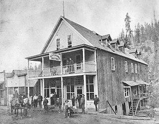
Sumpter is a city in Baker County, Oregon, United States. The population was 204 at the 2010 census. Sumpter is named after Fort Sumter by its founders. The name was inspired by a rock as smooth and round as a cannonball, which reminded a local resident of the American Civil War and Fort Sumter.
Bayhorse is a ghost town in Custer County, Idaho, United States, founded in 1877, though active development of the town did not begin until 1880. Bayhorse was once a thriving mining town, principally supported by large nearby silver deposit. In 1882, the town increased its smelting capabilities, producing $300,000 worth of silver over the course of the year. By 1885, the town had grown to 300 residents, supported by a mill, three stores, a hotel, a restaurant, a meat market, a lodging house, and five saloons. The same year, the town built a refinery, allowing the mining industry to issue silver bars and by 1900, the town had extracted over $10 million in total ores, including silver, lead, and copper.

Canemah was an early settlement in the U.S. state of Oregon located near the Willamette River. Canemah was annexed to Oregon City in 1928.

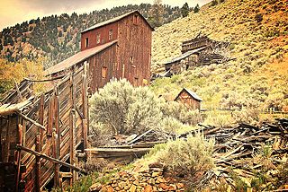
Cornucopia is a ghost town built during the gold mining boom of the 1880s in Eastern Oregon, United States. The town was officially platted in 1886 and was a mining town with various levels of success until it was abandoned in 1942. It is now primarily a tourist attraction as a ghost town. It is located east of Baker City high in the mountains of Pine Valley almost due north of Halfway, Oregon, on Oregon Route 86.

Wolf Creek Inn State Heritage Site is a state park in the U.S. state of Oregon, administered by the Oregon Parks and Recreation Department.

Leesburg is an unincorporated community in Lemhi County, Idaho, United States. It lies at 45°13′26″N114°6′50″W, along Napias Creek in the Salmon National Forest, west of Salmon. Its altitude is 6,653 feet (2,028 m).
Buncom is an abandoned mining town at the confluence of the Little Applegate River and Sterling Creek in Jackson County, Oregon, United States. It is approximately 20 miles (32 km) southwest of Medford, at an elevation of 1,783 feet (543.5 m) above sea level. The site is promoted by the local historical society as a ghost town.
Sterlingville was a boomtown along Sterling Creek in Jackson County, Oregon, United States, once home to the largest hydraulic mine in Oregon. It has since been abandoned and destroyed.
Placer is an unincorporated community in Josephine County, Oregon, United States, on Grave Creek a few miles east of Interstate 5. Established during the local gold mining boom, it is considered a ghost town.
Lime is an unincorporated community and ghost town in the northwest United States, located in Baker County, Oregon. Five miles (8 km) north of Huntington on Interstate 84, it is near the confluence of Marble Creek and the Burnt River on the Union Pacific Railroad. The historic Oregon Trail passes through Lime.
Bourne is a ghost town in Baker County, Oregon, United States about 7 miles (11 km) north of Sumpter in the Blue Mountains. It lies on Cracker Creek and is within the Wallowa–Whitman National Forest. Platted in 1902, the former gold mining boomtown is considered a ghost town today.

Susanville is an unincorporated community in Grant County, Oregon, United States, in the Blue Mountains about two miles up Elk Creek from Galena. The place was started as a gold mining camp in 1862 or 1864 and is now considered a ghost town.
Nonpareil is an unincorporated historic community in Douglas County, Oregon, United States. It is about 8 miles (13 km) east of Sutherlin, near Calapooya Creek. The population of the area was about 202 in 2000. Nonpareil was the birthplace of novelist H. L. Davis.
Clifton is an unincorporated community in Clatsop County, Oregon, United States. It is located north of U.S. Route 30, about nine miles northwest of Westport on the south bank of the Columbia River. It is on Clifton Channel across from Tenasillahe Island.

Tinton is a ghost town in the Black Hills of Lawrence County, South Dakota, United States. Founded in 1876, it started out as a gold mining camp and later began to produce tin. It had a heavy decline in the early 20th century due to the decline in the mining industry, and the town was fully abandoned by the 1950s. Beginning in 1937, it was home to the Dakota Tin and Gold Mine, which was listed on the National Register of Historic Places in 2005.
Randolph is an unincorporated community in Coos County, Oregon, United States. It is on the north bank the Coquille River about 7 miles (11 km) north of Bandon and about 3 miles east of the Pacific Ocean. Randolph was originally located about three miles to the northwest near the current Whiskey Run Beach, where it was a "black sand" gold mining boomtown in the 1850s. Today that boomtown is a ghost town because there are no significant structures left at the site, but the community on the Coquille River has several homes and a historic cemetery.
Hobsonville is an unincorporated community in Tillamook County, Oregon, United States. Although it is considered a ghost town, it is still classified as a populated place by the United States Geological Survey (USGS). Hobsonville is on the east shore of Tillamook Bay, about 2 miles south of Garibaldi via U.S. Route 101 or about a mile from Garibaldi across Miami Cove.


