
Goshen is an unincorporated community in Lane County, Oregon, United States. It is located at the junction of Oregon Route 58, Oregon Route 99, and Interstate 5.

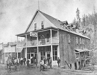
Waldo is a ghost town located in Josephine County, Oregon, United States, about three miles from the California border. It was settled in 1852 as a gold mining camp called Sailor's Diggings. The place was later renamed "Waldo" in honor of William Waldo, who in 1853 was the Whig candidate for governor of California. This was apparently because, believing the settlement was in California, William Waldo campaigned there and convinced the populace that they should vote for him. The town was the first county seat of Josephine County. The post office for Waldo was established in 1856; service was discontinued in 1928.

Flora is an unincorporated community in Wallowa County, Oregon, United States. It is located about 35 miles north of Enterprise, just off Oregon Route 3, and is considered a ghost town. Its elevation is 4350 ft. The community includes 6 mines.
Kerby is an unincorporated community and census-designated place (CDP) in Josephine County, Oregon, United States, north of Cave Junction on U.S. Route 199. As of the 2010 census the population was 595. Despite its population and numerous businesses, it is often listed in tourist guides as a ghost town, because of the number of historic buildings left from its days as a gold-mining town. Kerby came into existence between 1854 and 1857.

Wendling is an unincorporated community in Lane County, Oregon, United States, located northeast of Marcola. Wendling's post office operated from 1899 to 1952. It was named for George X. Wendling, a local lumberman. Wendling was created as a company town for the Booth-Kelly Lumber Company.
Placer is an unincorporated community in Josephine County, Oregon, United States, on Grave Creek a few miles east of Interstate 5. Established during the local gold mining boom, it is considered a ghost town.

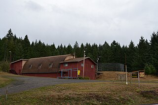
Hardman is a historic community located in southern Morrow County, in the U.S. state of Oregon. It is on Oregon Route 207 about 20 miles (32 km) southwest of Heppner and 32 miles (51 km) north of Spray. Hardman is at an elevation of about 3,600 feet (1,100 m) in an agricultural area slightly west of the Blue Mountains of northeastern Oregon. Rock Creek, a tributary of the Columbia River, flows northwest by Hardman and to its south to meet the river at Lake Umatilla. A former social and commercial center for surrounding farm communities, Hardman became a ghost town following the completion of a railroad to Heppner in the 1920s. The main surviving commercial building, the Hardman IOOF Lodge Hall, was added to the National Register of Historic Places (NRHP) in 2012.
Goldson is an unincorporated community in Lane County, Oregon, United States on Oregon Route 36 near Bear Creek, about 3.5 miles (5.6 km) from Cheshire. Goldson post office was established in 1891 and named for the first postmaster, J. M. Goldson. It ran until 1934. The community's elevation is 404 feet (123 m).
Bourne is a ghost town in Baker County, Oregon, United States about 7 miles (11 km) north of Sumpter in the Blue Mountains. It lies on Cracker Creek and is within the Wallowa–Whitman National Forest. Platted in 1902, the former gold mining boomtown is considered a ghost town today.
Wonder is an unincorporated community in Josephine County, Oregon, United States, on U.S. Route 199 about 13 miles west of Grants Pass and 8 miles east of Selma. It is within the Rogue River – Siskiyou National Forest.

Lancaster is an unincorporated community in Lane County, Oregon, United States. It is located about two miles south of Harrisburg and two miles north of Junction City, on Oregon Route 99E near the Willamette River.
Leland is an unincorporated community in Josephine County, Oregon, United States. It lies in the Klamath Mountains along Grave Creek, a tributary of the Rogue River.
Provolt is an unincorporated community in Jackson County, Oregon, United States. It is about 15 miles (24 km) southeast of Grants Pass on Oregon Route 238, near the Applegate River on the county line between Jackson and Josephine counties.
Kofa, also historically known as Kofa Station, is a populated place situated in Yuma County, Arizona, United States. It is located in the northern San Cristobal Valley, along the Union Pacific Railroad's Roll Industrial Lead.
Randolph is an unincorporated community in Coos County, Oregon, United States, founded as a "black sand" gold mining boomtown in the 1850s. Although it is considered a ghost town because there are no significant structures left at the site, the USGS classifies Randolph as a populated place. It is on the north bank the Coquille River about 7 miles (11 km) north of Bandon and about 3 miles east of the Pacific Ocean.
Persist is a ghost town in Jackson County, in the U.S. state of Oregon. It lies in the mountains north of Lost Creek Lake on the Rogue River downstream of Prospect.
Bacona is an unincorporated community in northern Washington County, Oregon, United States.
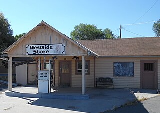
West Side is an unincorporated community in Lake County, Oregon, located southwest of the county seat of Lakeview.

Blitzen is a ghost town in the Catlow Valley of southern Harney County, Oregon.

Zumwalt is a ghost town in Wallowa County, Oregon. It is located on the Zumwalt Prairie.


