Redwood, Oregon

Last updated

Redwood, Oregon
Josephine County Oregon Incorporated and Unincorporated areas Redwood Highlighted.svg
Location of Redwood, Oregon
Coordinates: 42°25′19″N123°23′14″W / 42.42194°N 123.38722°W / 42.42194; -123.38722
Country United States
State Oregon
County Josephine
Area
[1]
  Total3.51 sq mi (9.09 km2)
  Land3.46 sq mi (8.95 km2)
  Water0.06 sq mi (0.14 km2)
Elevation
935 ft (285 m)
Population
 (2020) [2]
  Total2,702
  Density781.83/sq mi (301.90/km2)
Time zone UTC-8 (Pacific (PST))
  Summer (DST) UTC-7 (PDT)
FIPS code 41-61250 [3]
GNIS feature ID1867477 [4]

Redwood is a census-designated place (CDP) in Josephine County, Oregon, United States. [5] The population was 2,627 at the 2010 census, [6] down from 5,844 at the 2000 census as it has lost territory to the neighboring city of Grants Pass.

Contents

Geography

Redwood is in eastern Josephine County, in the valley of the Rogue River. It is bordered to the east by the city of Grants Pass, the county seat. According to the United States Census Bureau, the CDP has a total area of 3.5 square miles (9.1 km2), down from 4.9 square miles (12.7 km2) in 2000. As of 2010, 0.05 square miles (0.14 km2) within Redwood, or 1.54%, are water. The community is 935 feet (285 m) above sea level. [5]

U.S. Route 199 runs through the southern side of Redwood, leading east into Grants Pass and southwest 25 miles (40 km) to Cave Junction.

Demographics

Historical population
CensusPop.Note
2020 2,702
U.S. Decennial Census [7] [2]

As of the census [3] of 2000, there were 5,844 people, 2,390 households, and 1,684 families residing in the CDP. The population density was 1,207.3 inhabitants per square mile (466.1/km2). There were 2,529 housing units at an average density of 522.5 per square mile (201.7/km2). The racial makeup of the CDP was 94.87% White, 0.31% African American, 1.01% Native American, 0.33% Asian, 0.07% Pacific Islander, 0.77% from other races, and 2.65% from two or more races. Hispanic or Latino of any race were 3.68% of the population.

There were 2,390 households, out of which 30.5% had children under the age of 18 living with them, 54.5% were married couples living together, 11.7% had a female householder with no husband present, and 29.5% were non-families. 24.0% of all households were made up of individuals, and 11.4% had someone living alone who was 65 years of age or older. The average household size was 2.42 and the average family size was 2.84.

In the CDP, the population was spread out, with 24.7% under the age of 18, 5.8% from 18 to 24, 26.5% from 25 to 44, 21.5% from 45 to 64, and 21.4% who were 65 years of age or older. The median age was 40 years. For every 100 females, there were 92.1 males. For every 100 females age 18 and over, there were 90.1 males.

The median income for a household in the CDP was $33,310, and the median income for a family was $36,922. Males had a median income of $29,750 versus $21,270 for females. The per capita income for the CDP was $15,025. About 10.3% of families and 12.8% of the population were below the poverty line, including 16.6% of those under age 18 and 5.4% of those age 65 or over.

Related Research Articles

<span class="mw-page-title-main">Terramuggus, Connecticut</span> Census-designated place in Connecticut, United States

Terramuggus is a census-designated place (CDP) in the town of Marlborough, Hartford County, Connecticut, United States. It contains the town center village and surrounding areas. The population was 1,025 at the 2010 census.

<span class="mw-page-title-main">Cypress Gardens, Florida</span> Census-designated place in Florida, United States

Cypress Gardens is a census-designated place (CDP) in Polk County, Florida, United States. The population was 10,169 at the 2020 census. It is part of the Lakeland–Winter Haven Metropolitan Statistical Area.

<span class="mw-page-title-main">Oak Park, Indiana</span> CDP in Indiana, United States

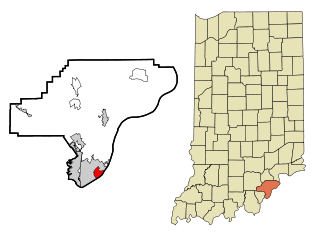
Oak Park is a census-designated place (CDP) in Clark County, Indiana, United States. The population was 5,379 at the 2000 census.

<span class="mw-page-title-main">Chewsville, Maryland</span> CDP in Maryland, United States

Chewsville is a census-designated place (CDP) in Washington County, Maryland, United States. The population was 293 at the 2000 census.

<span class="mw-page-title-main">Mount Lena, Maryland</span> CDP in Maryland, United States

Mount Lena is a census-designated place (CDP) in Washington County, Maryland, United States. The population was 501 at the 2000 census.

<span class="mw-page-title-main">West Concord, Massachusetts</span> Census-designated place in Massachusetts, United States

West Concord is an unincorporated village and census-designated place (CDP) in the town of Concord in Middlesex County, Massachusetts, United States. The population was 6,320 at the 2020 census.

Redwood is a hamlet and census-designated place (CDP) in Jefferson County, New York, United States. As of the 2010 census, the population was 605.

<span class="mw-page-title-main">Flanders, New York</span> Hamlet and census-designated place in New York, United States

Flanders is a hamlet and a census-designated place (CDP) in Suffolk County, New York, United States. The population was 4,472 at the 2010 census. It is the location of the Big Duck.

<span class="mw-page-title-main">South Gastonia, North Carolina</span> Neighborhood in Gaston, North Carolina, United States

South Gastonia is a neighborhood of Gastonia in Gaston County, North Carolina, United States. The population was 5,433 at the 2000 census, at which time it was erroneously listed as a census-designated place. The majority of the community has now been annexed into the city of Gastonia and is now considered to be a neighborhood on the southside of Gastonia.

<span class="mw-page-title-main">Day Heights, Ohio</span> Census-designated place in Ohio, United States

Day Heights is a census-designated place (CDP) in Clermont County, Ohio, United States. The population was 2,625 at the 2020 census.

<span class="mw-page-title-main">Rosemount, Ohio</span> Census-designated place in Ohio, United States

Rosemount is a census-designated place (CDP) in Clay Township, Scioto County, Ohio, United States. The population was 2,112 at the 2010 census.

<span class="mw-page-title-main">West Hills, Pennsylvania</span> Census-designated place in Pennsylvania, United States

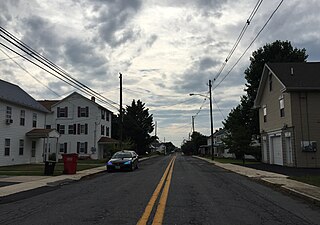
West Hills is a census-designated place (CDP) in Armstrong County, Pennsylvania, United States. The population was 1,228 at the 2020 census.

<span class="mw-page-title-main">Dentsville, South Carolina</span> Census-designated place in South Carolina, United States

Dentsville is a census-designated place (CDP) in Richland County, South Carolina, United States. The population was 14,062 at the 2010 census. It is part of the Columbia, South Carolina, Metropolitan Statistical Area.

<span class="mw-page-title-main">Redwood, Texas</span> Unincorporated community in Texas, United States

Redwood is an unincorporated community and census-designated place (CDP) in Guadalupe County, Texas, United States. The population was 4,003 at the 2020 census, down from 4,338 at the 2010 census. It is part of the San Antonio Metropolitan Statistical Area.

<span class="mw-page-title-main">Lake Bosworth, Washington</span> CDP in Washington, United States

Lake Bosworth is a census-designated place (CDP) in Snohomish County, Washington, United States. The population was 667 at the 2010 census.

<span class="mw-page-title-main">Bradley, West Virginia</span> Census-designated place in West Virginia, United States

Bradley is a census-designated place (CDP) in Raleigh County, West Virginia, United States, named in honor of General Omar Bradley, a field commander in North Africa and Europe during World War II and a General of the Army. The population was 2,040 at the 2010 census.

<span class="mw-page-title-main">Pine Plains (CDP), New York</span> Census-designated place in New York, United States

Pine Plains is a hamlet and census-designated place (CDP) in Dutchess County, New York, United States. The population was 1,142 at the 2020 census. It is part of the Poughkeepsie–Newburgh–Middletown, NY Metropolitan Statistical Area as well as the larger New York–Newark–Bridgeport, NY-NJ-CT-PA Combined Statistical Area.

<span class="mw-page-title-main">Minetto (CDP), New York</span> CDP in New York, United States

Minetto is a hamlet in Oswego County, New York, United States. The population was 1,069 at the 2010 census.

<span class="mw-page-title-main">Redwood Valley, California</span> Census-designated place in California, United States

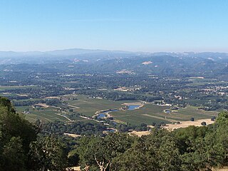
Redwood Valley is a census-designated place (CDP) in Mendocino County, California, United States. It is located 9 miles (14 km) north of Ukiah, the county seat, at an elevation of 722 feet (220 m), and comprises the northern portion of the Ukiah Valley. It is about 15 miles (24 km) southeast of Willits. Potter Valley is to the east and Calpella to the south. The ZIP Code is 95470, and the community is in area code 707. The population of the CDP was 1,843 at the 2020 census.

<span class="mw-page-title-main">Gorham (CDP), Maine</span> Census-designated place in Maine, United States

Gorham is a census-designated place (CDP) in the town of Gorham, in Cumberland County, Maine, United States. The population was 6,882 at the 2010 census. It is part of the Portland–South Portland–Biddeford, Maine Metropolitan Statistical Area.

References

  1. "ArcGIS REST Services Directory". United States Census Bureau. Retrieved October 12, 2022.
  2. 1 2 "Census Population API". United States Census Bureau. Retrieved October 12, 2022.
  3. 1 2 "U.S. Census website". United States Census Bureau . Retrieved January 31, 2008.
  4. "US Board on Geographic Names". United States Geological Survey. October 25, 2007. Retrieved January 31, 2008.
  5. 1 2 "Redwood". Geographic Names Information System . United States Geological Survey, United States Department of the Interior. May 15, 2000. Retrieved January 22, 2010.
  6. "Geographic Identifiers: 2010 Census Summary File 1 (G001): Redwood CDP, Oregon". American Factfinder. U.S. Census Bureau. Archived from the original on February 13, 2020. Retrieved November 2, 2018.
  7. "Census of Population and Housing". Census.gov. Retrieved June 4, 2016.