Goodridge, Minnesota

Last updated
Goodridge
Goodridge, Minnesota 10-14-2007.jpg
Downtown Goodridge
Pennington County Minnesota Incorporated and Unincorporated areas Goodridge Highlighted.svg
Location of Goodridge, Minnesota
Coordinates: 48°8′38″N95°48′21″W / 48.14389°N 95.80583°W / 48.14389; -95.80583 Coordinates: 48°8′38″N95°48′21″W / 48.14389°N 95.80583°W / 48.14389; -95.80583
CountryUnited States
State Minnesota
County Pennington
Area
[1]
  Total0.19 sq mi (0.49 km2)
  Land0.19 sq mi (0.49 km2)
  Water0.00 sq mi (0.00 km2)
Elevation
1,171 ft (357 m)
Population
 (2020) [2]
  Total112
  Estimate 
(2021) [3]
109
  Density595.74/sq mi (230.00/km2)
Time zone UTC-6 (CST)
  Summer (DST) UTC-5 (CDT)
ZIP code
56725
Area code 218
FIPS code 27-24470 [4]
GNIS feature ID0644226 [5]

Goodridge is a small city in Pennington County, Minnesota, United States. The population was 112 at the 2020 census. [2] The city is located within Goodridge Township, but is politically independent.

Contents

History

A post office called Goodridge has been in operation since 1915. [6] The city was named for a ridge near the town site. [7]

Geography

According to the United States Census Bureau, the city has a total area of 0.19 square miles (0.49 km2), all land. [8]

State Highway 1, State Highway 219, and County State-Aid Highway 24 are three of the main routes in the community.

Goodridge was the eastern terminus of the Minnesota Northwestern Electric Railway from 1914 until that company's demise in 1940. [9]

Demographics

Historical population
CensusPop.Note
1920 231
1930 171−26.0%
1940 1741.8%
1950 144−17.2%
1960 134−6.9%
1970 1447.5%
1980 19132.6%
1990 115−39.8%
2000 98−14.8%
2010 13234.7%
2020 112−15.2%
2021 (est.)109 [3] −2.7%
U.S. Decennial Census [10]
2020 Census [2]

2010 census

As of the census of 2010, there were 132 people, 60 households, and 36 families residing in the city. The population density was 694.7 inhabitants per square mile (268.2/km2). There were 66 housing units at an average density of 347.4 per square mile (134.1/km2). The racial makeup of the city was 97.0% White, 0.8% African American, 0.8% Native American, and 1.5% from other races. Hispanic or Latino of any race were 4.5% of the population.

There were 60 households, of which 35.0% had children under the age of 18 living with them, 33.3% were married couples living together, 21.7% had a female householder with no husband present, 5.0% had a male householder with no wife present, and 40.0% were non-families. 40.0% of all households were made up of individuals, and 10% had someone living alone who was 65 years of age or older. The average household size was 2.20 and the average family size was 2.89.

The median age in the city was 41.7 years. 30.3% of residents were under the age of 18; 5.3% were between the ages of 18 and 24; 26.5% were from 25 to 44; 27.3% were from 45 to 64; and 10.6% were 65 years of age or older. The gender makeup of the city was 49.2% male and 50.8% female.

2000 census

As of the census [4] of 2000, there were 98 people, 47 households, and 26 families residing in the city. The population density was 523.1 inhabitants per square mile (202.0/km2). There were 53 housing units at an average density of 282.9 per square mile (109.2/km2). The racial makeup of the city was 100.00% White. Hispanic or Latino of any race were 2.04% of the population.

There were 47 households, out of which 36.2% had children under the age of 18 living with them, 31.9% were married couples living together, 23.4% had a female householder with no husband present, and 42.6% were non-families. 42.6% of all households were made up of individuals, and 8.5% had someone living alone who was 65 years of age or older. The average household size was 2.09 and the average family size was 2.85.

In the city, the population was spread out, with 31.6% under the age of 18, 5.1% from 18 to 24, 31.6% from 25 to 44, 23.5% from 45 to 64, and 8.2% who were 65 years of age or older. The median age was 34 years. For every 100 females, there were 104.2 males. For every 100 females age 18 and over, there were 97.1 males.

The median income for a household in the city was $17,292, and the median income for a family was $23,125. Males had a median income of $26,250 versus $14,688 for females. The per capita income for the city was $12,636. There were 19.0% of families and 23.8% of the population living below the poverty line, including 43.5% of under eighteen and none of those over 64.

Related Research Articles

<span class="mw-page-title-main">Wilton, Minnesota</span> City in Minnesota, United States

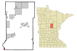
Wilton is a city in Beltrami County, Minnesota, United States. The population was 204 at the 2010 census. Wilton is considered a bedroom community of Bemidji.

<span class="mw-page-title-main">Felton, Minnesota</span> City in Minnesota, United States

Felton is a city in Clay County, Minnesota, United States. The population was 177 at the 2020 census.

<span class="mw-page-title-main">Sabin, Minnesota</span> City in Minnesota, United States

Sabin is a city in Clay County, Minnesota, United States. The population was 619 at the 2020 census.

<span class="mw-page-title-main">Emily, Minnesota</span> City in Minnesota, United States

Emily is a city in Crow Wing County, Minnesota, United States. The population was 813 at the 2010 census. It is part of the Brainerd Micropolitan Statistical Area.

<span class="mw-page-title-main">Fort Ripley, Minnesota</span> City in Minnesota, United States

Fort Ripley is a city in Crow Wing County, Minnesota, United States, near the confluence of the Mississippi and Nokasippi Rivers. The population was 69 at the 2010 census. It is part of the Brainerd Micropolitan Statistical Area.

<span class="mw-page-title-main">Jenkins, Minnesota</span> City in Minnesota, United States

Jenkins is a city in Crow Wing County, Minnesota, United States. The population was 430 at the 2010 census. It is part of the Brainerd Micropolitan Statistical Area.

<span class="mw-page-title-main">Garfield, Minnesota</span> City in Minnesota, United States

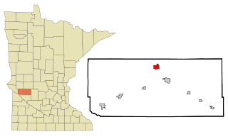
Garfield is a city in Douglas County, Minnesota, United States. The population was 349 at the 2020 census.

<span class="mw-page-title-main">Kenyon, Minnesota</span> City in Minnesota, United States

Kenyon is a city in southwestern Goodhue County, Minnesota, United States, located along the North Fork of the Zumbro River. It was founded in 1856 and named in honor of Kenyon College. It is known for the Boulevard of roses on main street, which is the namesake of the town festival "Rosefest" held every August. The population was 1,815 at the 2010 census.

<span class="mw-page-title-main">Coleraine, Minnesota</span> City in Minnesota, United States

Coleraine is a city in Itasca County, Minnesota, United States. The population was 1,970 at the 2010 census. The community was named after Thomas F. Cole, President of the Oliver Iron Mining Company.

<span class="mw-page-title-main">Lake Bronson, Minnesota</span> City in Minnesota, United States

Lake Bronson is a city in Kittson County, Minnesota, United States. The population was 178 at the 2020 census. Lake Bronson State Park is nearby.

<span class="mw-page-title-main">Truman, Minnesota</span> City in Minnesota, United States

Truman is a city in Martin County, Minnesota, United States. The population was 1,115 at the 2010 census. In 2018, the U.S. Census Bureau estimated the population to be 1,053.

<span class="mw-page-title-main">Bluffton, Minnesota</span> City in Minnesota, United States

Bluffton is a city in Otter Tail County, Minnesota, United States, along the Leaf River. The population was 210 at the 2020 census.

<span class="mw-page-title-main">Parkers Prairie, Minnesota</span> City in Minnesota, United States

Parkers Prairie is a city in Otter Tail County, Minnesota, United States. The population was 1,020 at the 2020 census.

Goodridge Township is a township in Pennington County, Minnesota, United States. The population was 54 at the 2000 census. the city of Goodridge is located within the township, but is politically independent.

<span class="mw-page-title-main">Sedan, Minnesota</span> City in Minnesota, United States

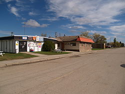
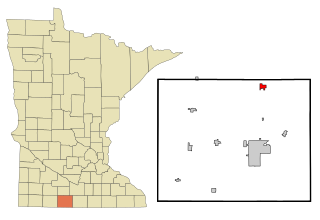
Sedan is a city in Pope County, Minnesota, United States. The population was 43 at the 2020 census.

<span class="mw-page-title-main">Buffalo Lake, Minnesota</span> City in Minnesota, United States

Buffalo Lake is a city in Renville County, Minnesota, United States. The population was 733 at the 2010 census.

<span class="mw-page-title-main">Clontarf, Minnesota</span> City in Minnesota, United States

Clontarf is a city in Swift County, Minnesota, United States. The population was 164 at the 2010 census.

<span class="mw-page-title-main">Lakeland Shores, Minnesota</span> City in Minnesota, United States

Lakeland Shores is a city in Washington County, Minnesota, United States. The population was 311 at the 2010 census.

<span class="mw-page-title-main">St. Stephen, Minnesota</span> City in Minnesota, United States

Saint Stephen is a city in Stearns County, Minnesota, United States. The population was 851 at the 2010 census.

<span class="mw-page-title-main">Bellechester, Minnesota</span> City in Minnesota, United States

Bellechester is a city in Goodhue and Wabasha counties in the U.S. state of Minnesota. The population was 175 at the 2010 census. Most of Bellchester is in Goodhue County, with only a small part extending into Wabasha County.

References

  1. "2020 U.S. Gazetteer Files". United States Census Bureau. Retrieved July 24, 2022.
  2. 1 2 3 "Explore Census Data". United States Census Bureau . Retrieved May 19, 2022.
  3. 1 2 "City and Town Population Totals: 2020-2021". United States Census Bureau. July 4, 2022. Retrieved July 4, 2022.
  4. 1 2 "U.S. Census website". United States Census Bureau . Retrieved January 31, 2008.
  5. "US Board on Geographic Names". United States Geological Survey. October 25, 2007. Retrieved January 31, 2008.
  6. "Pennington County". Jim Forte Postal History. Retrieved July 29, 2015.
  7. Upham, Warren (1920). Minnesota Geographic Names: Their Origin and Historic Significance. Minnesota Historical Society. p.  406.
  8. "US Gazetteer files 2010". United States Census Bureau. Archived from the original on January 25, 2012. Retrieved November 13, 2012.
  9. Prosser, Richard S. (1966). Rails to the North Star. University of Minnesota Press. ISBN   978-0-8166-5267-9.
  10. "Census of Population and Housing". Census.gov. Retrieved June 4, 2015.