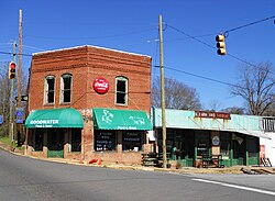
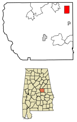
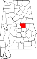
Goodwater, Alabama

Last updated

Goodwater, Alabama
Goodwater Alabama.JPG
Goodwater in 2011
Coosa County Alabama Incorporated and Unincorporated areas Goodwater Highlighted 0130640.svg
Location of Goodwater in Coosa County, Alabama.
Coordinates: 33°3′35″N86°3′10″W / 33.05972°N 86.05278°W / 33.05972; -86.05278
Country United States
State Alabama
County Coosa
Area
[1]
  Total6.52 sq mi (16.90 km2)
  Land6.49 sq mi (16.82 km2)
  Water0.03 sq mi (0.08 km2)
Elevation
840 ft (256 m)
Population
 (2020)
  Total1,291
  Density198.80/sq mi (76.75/km2)
Time zone UTC-6 (Central (CST))
  Summer (DST) UTC-5 (CDT)
ZIP code
35072
Area code 256
FIPS code 01-30640
GNIS feature ID0159683
Website www.cityofgoodwater.com

Goodwater is a town in Coosa County, Alabama, United States. At the 2020 census, the population was 1,291. It is part of the Talladega-Sylacauga Micropolitan Statistical Area.

Contents

Geography

Goodwater is located near the northeast corner of Coosa County at 33°03′36″N86°03′11″W / 33.059988°N 86.053043°W / 33.059988; -86.053043 . [2]

According to the U.S. Census Bureau, the city has a total area of 6.5 square miles (16.9 km2), of which 0.03 square miles (0.08 km2), or 0.45%, is water. [3]

Climate

According to the Köppen climate classification, Goodwater has a humid subtropical climate (abbreviated Cfa).

Climate data for Goodwater, 1991–2020 simulated normals (837 ft elevation)
MonthJanFebMarAprMayJunJulAugSepOctNovDecYear
Mean daily maximum °F (°C)55.0
(12.8)
59.4
(15.2)
67.1
(19.5)
74.5
(23.6)
81.3
(27.4)
87.3
(30.7)
90.1
(32.3)
89.2
(31.8)
84.6
(29.2)
75.7
(24.3)
65.3
(18.5)
57.4
(14.1)
73.9
(23.3)
Daily mean °F (°C)43.7
(6.5)
47.3
(8.5)
54.1
(12.3)
61.5
(16.4)
69.4
(20.8)
76.3
(24.6)
79.5
(26.4)
78.6
(25.9)
73.4
(23.0)
63.0
(17.2)
52.7
(11.5)
46.2
(7.9)
62.1
(16.8)
Mean daily minimum °F (°C)32.4
(0.2)
35.2
(1.8)
41.4
(5.2)
48.4
(9.1)
57.4
(14.1)
65.5
(18.6)
68.9
(20.5)
68.2
(20.1)
62.2
(16.8)
50.4
(10.2)
39.9
(4.4)
35.1
(1.7)
50.4
(10.2)
Average precipitation inches (mm)5.48
(139.11)
5.46
(138.64)
5.62
(142.79)
4.87
(123.62)
4.30
(109.20)
4.81
(122.20)
4.89
(124.08)
4.46
(113.40)
3.61
(91.81)
3.25
(82.64)
4.42
(112.15)
5.41
(137.29)
56.58
(1,436.93)
Average dew point °F (°C)34.3
(1.3)
36.9
(2.7)
42.3
(5.7)
49.6
(9.8)
59.4
(15.2)
66.9
(19.4)
70.2
(21.2)
69.4
(20.8)
64.2
(17.9)
53.8
(12.1)
43.2
(6.2)
37.9
(3.3)
52.3
(11.3)
Source: PRISM Climate Group [4]

Demographics

Historical population
CensusPop.Note
1890 589
1900 72823.6%
1910 7401.6%
1920 92024.3%
1930 9968.3%
1940 1,0283.2%
1950 1,22719.4%
1960 2,02364.9%
1970 2,1727.4%
1980 1,895−12.8%
1990 1,840−2.9%
2000 1,633−11.2%
2010 1,475−9.7%
2020 1,291−12.5%
U.S. Decennial Census [5]
2013 Estimate [6]

2020 census

Goodwater racial composition [7]
RaceNum.Perc.
White (non-Hispanic)27321.15%
Black or African American (non-Hispanic)97275.29%
Asian 20.15%
Other/Mixed 382.94%
Hispanic or Latino 50.46%

As of the 2020 United States census, there were 1,291 people, 484 households, and 230 families residing in the town.

2010 census

At the 2010 census there were 1,475 people, 618 households, and 394 families living in the city. The population density was 227 inhabitants per square mile (88/km2). There were 708 housing units at an average density of 108.4 per square mile (41.9/km2). The racial makeup of the city was 73.7% Black or African American, 24.3% White, 0.7% Native American, 0.0% Asian, 0.7% from other races, and 0.5% from two or more races. 0.7% of the population were Hispanic or Latino of any race. [8] The age distribution was 22.2% under the age of 18, 6.8% from 18 to 24, 22.9% from 25 to 44, 28.3% from 45 to 64, and 19.7% 65 or older. The median age was 43.6 years. For every 100 females, there were 88.1 males. For every 100 females age 18 and over, there were 90.4 males.

The median household income was $24,909 and the median family income was $31,081. Males had a median income of $24,554 versus $24,348 for females. The per capita income for the city was $12,957. About 23.6% of families and 28.2% of the population were below the poverty line, including 48.2% of those under age 18 and 18.3% of those age 65 or over.

2000 census

At the 2000 census there were 1,633 people, 621 households, and 424 families living in the city. The population density was 249.6 inhabitants per square mile (96.4/km2). There were 727 housing units at an average density of 111.1 per square mile (42.9/km2). The racial makeup of the city was 73.30% Black or African American, 25.66% White, 0.31% Native American, 0.12% Asian, 0.06% from other races, and 0.55% from two or more races. 0.55% of the population were Hispanic or Latino of any race. [9] The age distribution was 25.3% under the age of 18, 8.3% from 18 to 24, 25.3% from 25 to 44, 23.4% from 45 to 64, and 17.8% 65 or older. The median age was 38 years. For every 100 females, there were 87.5 males. For every 100 females age 18 and over, there were 80.7 males.

The median household income was $22,188 and the median family income was $28,819. Males had a median income of $22,414 versus $17,464 for females. The per capita income for the city was $10,602. About 21.0% of families and 23.3% of the population were below the poverty line, including 33.8% of those under age 18 and 12.0% of those age 65 or over.

Notable people

Related Research Articles

<span class="mw-page-title-main">Coosa County, Alabama</span> County in Alabama, United States

Coosa County is located in the east central portion of the U.S. state of Alabama. As of the 2020 census the population was 10,387. Its county seat is Rockford. Its name derives from a town of the Creek tribe and the Coosa River, which forms one of the county borders.

<span class="mw-page-title-main">Elmore County, Alabama</span> County in Alabama, United States

Elmore County is a county located in the east central portion of the U.S. state of Alabama. As of the 2020 census, the population was 87,977. Its county seat is Wetumpka. Its name is in honor of General John A. Elmore.

<span class="mw-page-title-main">Shelby County, Alabama</span> County in Alabama, United States

Shelby County is located in the central portion of the U.S. state of Alabama. As of the 2020 census the population was 223,024, making it the sixth-most populous county in Alabama. The county seat is Columbiana. Its largest city is Alabaster. The county is named in honor of Isaac Shelby, Governor of Kentucky from 1792 to 1796 and again from 1812 to 1816. Shelby County is included in the Birmingham–Hoover, AL Metropolitan Statistical Area.

<span class="mw-page-title-main">Tallapoosa County, Alabama</span> County in Alabama, United States

Tallapoosa County is located in the east-central portion of the U.S. state of Alabama. As of the 2020 census, the population was 41,311. Its county seat is Dadeville. Its largest city is Alexander City.

<span class="mw-page-title-main">Polk County, Georgia</span> County in Georgia, United States

Polk County is a county located in the northwestern part of the U.S. state of Georgia. As of the 2020 census, the population was 42,853. The county seat is Cedartown. The county was created on December 20, 1851, by an act of the Georgia General Assembly and named after James K. Polk, the eleventh President of the United States.

<span class="mw-page-title-main">Floyd County, Georgia</span> County in Georgia, United States

Floyd County is a county located in the northwestern part of the U.S. state of Georgia. As of the 2020 United States Census, the population was 98,584. The county seat is Rome.

<span class="mw-page-title-main">Southside, Alabama</span> City in Alabama, United States

Southside is a city located in Etowah County in the U.S. state of Alabama. It is included in the Gadsden Metropolitan Statistical Area. It incorporated in 1957. The population was 8,412 at the time of the 2010 United States Census. Located 8 to 12 miles south of downtown Gadsden, Southside is one of the fastest-growing cities in northeast Alabama. The current Mayor, elected in 2020, is Dana Snyder.

<span class="mw-page-title-main">Hokes Bluff</span> City in Alabama, United States

Hokes Bluff is a city in Etowah County, Alabama, United States. It is part of the Gadsden Metropolitan Statistical Area. At the 2020 census, the population was 4,446.

<span class="mw-page-title-main">Rainbow City, Alabama</span> City in Alabama, United States

Rainbow City is a city in Etowah County, Alabama, United States. It incorporated in 1950. The population was 9,602 at the 2010 census. It is part of the Gadsden Metropolitan Statistical Area.

<span class="mw-page-title-main">Riverside, Alabama</span> City in Alabama, United States

Riverside is a city in St. Clair County, Alabama, United States. It incorporated in 1886. At the 2010 census the population was 2,208, up from 1,564 in 2000.

<span class="mw-page-title-main">East Dubuque, Illinois</span> City in Illinois, United States

East Dubuque is a city in Jo Daviess County, Illinois, United States. The population was 1,505 at the 2020 census, down from 1,704 in 2010. East Dubuque is located alongside the Mississippi River. Across the river is the city of Dubuque, Iowa. The city limits extend along the river to the Illinois – Wisconsin border.

<span class="mw-page-title-main">Sidney, Indiana</span> Town in Indiana, United States

Sidney is a town in Jackson Township, Kosciusko County, in the U.S. state of Indiana. The population was 83 at the 2010 census.

Plainfield Township is a civil township of Iosco County in the U.S. state of Michigan. The population was 3,799 at the 2010 census, down from 4,292 at the 2000 census.

<span class="mw-page-title-main">Lakewood Club, Michigan</span> Village in Michigan, United States

Lakewood Club is a village in Dalton Township of Muskegon County in the U.S. state of Michigan. The population was 1,340 at the 2020 census.

<span class="mw-page-title-main">Ortonville, Michigan</span> Village in Michigan, United States

Ortonville is a village in north Oakland County in the U.S. state of Michigan. The village is within Brandon Township, although some development near the village lies within adjacent Oakland County, Groveland township and Lapeer County, Hadley township. The population was 1,291 as of the 2021 Census estimate. Ortonville lies on the northern edge of Metro Detroit and is approximately 41 miles north of Downtown Detroit.

Mendon Township is a civil township of St. Joseph County in the U.S. state of Michigan. The population was 2,775 at the 2000 census. The Village of Mendon is located within the township.

<span class="mw-page-title-main">Wilson's Mills, North Carolina</span> Town in North Carolina, United States

Wilson's Mills is a town in Johnston County, North Carolina, United States. In 2010, the population was 2,277, up from 1,291 in 2000. As of 2018, the estimated population was 2,689.

<span class="mw-page-title-main">West Side Highway, Washington</span> Former CDP in Washington, United States

West Side Highway was a census-designated place (CDP) in Cowlitz County, Washington, named after a state highway running north–south between Longview and Castle Rock. As of the 2010 census, the CDP population was 5,517. Prior to the 2020 census, the CDP was split into two new CDPs, Beacon Hill and Lexington.

<span class="mw-page-title-main">Elmer City, Washington</span> Town in Washington, United States

Elmer City is a town in Okanogan County, Washington, United States. The population was 238 at the 2010 census.

<span class="mw-page-title-main">Kingwood, West Virginia</span> City in West Virginia, United States

Kingwood is a city in and the county seat of Preston County, West Virginia, United States. The population was 2,980 at the 2020 census. The city sits within the Allegheny Mountains above the Cheat River valley. It is part of the Morgantown metropolitan area.

References

  1. "2020 U.S. Gazetteer Files". United States Census Bureau. Retrieved October 29, 2021.
  2. "US Gazetteer files: 2010, 2000, and 1990". United States Census Bureau. February 12, 2011. Retrieved April 23, 2011.
  3. "Geographic Identifiers: 2010 Demographic Profile Data (G001): Goodwater town, Alabama". U.S. Census Bureau, American Factfinder. Archived from the original on February 12, 2020. Retrieved June 9, 2014.
  4. "PRISM Climate Group at Oregon State University". Northwest Alliance for Computational Science & Engineering (NACSE), based at Oregon State University. Retrieved March 15, 2023.
  5. "U.S. Decennial Census". Census.gov. Retrieved June 6, 2013.
  6. "Annual Estimates of the Resident Population: April 1, 2010 to July 1, 2013". Archived from the original on May 22, 2014. Retrieved June 3, 2014.
  7. "Explore Census Data". data.census.gov. Retrieved December 18, 2021.
  8. "U.S. Census website". United States Census Bureau . Retrieved July 19, 2015.
  9. "U.S. Census website". United States Census Bureau . Retrieved January 31, 2008.
  10. Thomas Koshy (May 8, 2007). Elementary Number Theory with Applications. Academic Press. p. 339. ISBN   978-0-08-054709-1.