Dollar, Alabama

Last updated
Dollar, Alabama
USA Alabama location map.svg
Red pog.svg
Dollar, Alabama
Usa edcp location map.svg
Red pog.svg
Dollar, Alabama
Coordinates: 32°52′43″N86°25′27″W / 32.87861°N 86.42417°W / 32.87861; -86.42417
Country United States
State Alabama
County Coosa
Elevation
443 ft (135 m)
Time zone UTC-6 (Central (CST))
  Summer (DST) UTC-5 (CDT)
Area code(s) 256 & 938, 334
GNIS feature ID156275 [1]

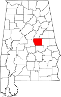
Dollar is an unincorporated community in Coosa County, Alabama, United States.

History

A post office called Dollar was established in 1883, and remained in operation until it was discontinued in 1921. [2]

Related Research Articles

Alabama River River in Alabama, United States

The Alabama River, in the U.S. state of Alabama, is formed by the Tallapoosa and Coosa rivers, which unite about 6 miles (10 km) north of Montgomery, near the town of Wetumpka.

Coosa County, Alabama County in Alabama, United States

Coosa County is located in the east central portion of the U.S. state of Alabama. As of the 2020 census the population was 10,387. Its county seat is Rockford. Its name derives from a town of the Creek tribe and the Coosa River, which forms one of the county borders.

Elmore County, Alabama County in Alabama, United States

Elmore County is a county located in the east central portion of the U.S. state of Alabama. As of the 2020 census, the population was 87,977. Its county seat is Wetumpka. Its name is in honor of General John A. Elmore.

Shelby County, Alabama County in Alabama, United States

Shelby County is located in the central portion of the U.S. state of Alabama. As of the 2020 census the population was 223,024. The county seat is Columbiana. The largest city is Alabaster. The county is named in honor of Isaac Shelby, Governor of Kentucky from 1792 to 1796 and again from 1812 to 1816.

Floyd County, Georgia County in Georgia, United States

Floyd County is a county located in the northwestern part of the U.S. state of Georgia. As of the 2010 United States Census, the population was 96,317. The county seat is Rome.

Rockford, Alabama Town in Alabama, United States

Rockford is a town in Coosa County, Alabama, United States. At the 2010 census the population was 477. The town is the county seat of Coosa County and is part of the Talladega-Sylacauga Micropolitan Statistical Area.

Wetumpka, Alabama City in Alabama, United States

Wetumpka is a city in and the county seat of Elmore County, Alabama, United States. At the 2010 census the population was 6,528. In the early 21st century Elmore County became one of the fastest-growing counties in the state. The city is considered part of the Montgomery Metropolitan Area.

Coosa River River in the United States of America

The Coosa River is a tributary of the Alabama River in the U.S. states of Alabama and Georgia. The river is about 280 miles (450 km) long.

Tallapoosa River

The Tallapoosa River runs 265 miles (426 km) from the southern end of the Appalachian Mountains in Georgia, United States, southward and westward into the Appalachian foothills in Alabama. It is formed by the confluence of McClendon Creek and Mud Creek in Paulding County, Georgia. Lake Martin at Alexander City, Alabama is a large and popular water recreation area formed by a dam on the river. The Tallapoosa joins the Coosa River about 10 miles (16 km) northeast of Montgomery near Wetumpka to form the Alabama River.

Coosa chiefdom Paramount chiefdom of Native Americans

The Coosa chiefdom was a powerful Native American paramount chiefdom in what are now Gordon and Murray counties in Georgia, in the United States. It was inhabited from about 1400 until about 1600, and dominated several smaller chiefdoms. The total population of Coosa's area of influence, reaching into present-day Tennessee and Alabama, has been estimated at 50,000.

Oostanaula River

The Oostanaula River is a principal tributary of the Coosa River, about 49 miles (79 km) long, formed by the confluence of the Conasauga and Coosawattee in northwestern Georgia in the United States. Via the Coosa and Alabama rivers, it is part of the watershed of the Mobile River, which flows to the Gulf of Mexico.

Coosa Bald

Coosa Bald, with an elevation of 4,280 feet (1,300 m), is tied with Double Spring Knob as the tenth-highest peak in Georgia. It is located in Union County and is the third-highest mountain in the county, behind Blood Mountain and Slaughter Mountain. Coosa Bald is located in the Chattahoochee National Forest and its peak is crossed by the Duncan Ridge Trail, a trail that connects with the Benton MacKaye Trail and the Appalachian Trail.

Montgomery metropolitan area Metropolitan statistical area in Alabama, United States

The Montgomery, Alabama Metropolitan Statistical Area is a in central Alabama. As of 2010, the MSA had a population of 374,536, ranking it 136th among United States.

Equality, Alabama Census-designated place in Alabama, United States

Equality is a census-designated place in Coosa, Elmore and Tallapoosa counties, Alabama, United States.

New Town, Georgia Unincorporated community in Georgia, United States

New Town(Cherokee: ᎤᏍᏔᎾᎵ, romanized: Ustanali) is an unincorporated community in Gordon County, Georgia, United States, located northeast of Calhoun. New Town is near the New Echota historic site, which was formerly part of the Cherokee Nation. Ashworth Middle School and Gordon Central High School are located in the New Town community.

Birmingham metropolitan area, Alabama Metropolitan area in Alabama, United States

The Birmingham metropolitan area, sometimes known as Greater Birmingham, is a metropolitan area in north central Alabama centered on Birmingham, Alabama.

Coosa County Jail United States historic place

The old Coosa County Jail is a former jail in Rockford, Alabama. It is the oldest extant stone jail in Alabama.

Marble Valley, Alabama Unincorporated community in Alabama, United States

Marble Valley is an unincorporated community in Coosa County, Alabama, United States.
New London, Alabama Unincorporated community in Alabama, United States

New London, also known as London, Kelly's Creek, or Kellys Creek, is an unincorporated community in St. Clair County, Alabama, United States.

Coosa, Georgia Unincorporated community in Georgia, United States

Coosa is an unincorporated community in Floyd County, Georgia, United States. The community is located at the intersection of Georgia routes 20 and 100, north of the Coosa River, 11 miles (18 km) west of Rome. Coosa has a post office with ZIP code 30129, which opened on December 28, 1846. An early variant name was "Missionary Station".

References

  1. "Dollar". Geographic Names Information System . United States Geological Survey.
  2. "Coosa County". Jim Forte Postal History. Retrieved 7 October 2014.