Kellyton, Alabama

Last updated

Kellyton, Alabama
Town
Kellyton Alabama.JPG
Kellyton, Alabama in 2011
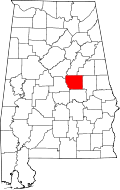
Coosa County Alabama Incorporated and Unincorporated areas Kellyton Highlighted 0139472.svg
Location of Kellyton in Coosa County, Alabama.
USA Alabama location map.svg
Red pog.svg
Kellyton
Coordinates: 32°58′47″N86°02′01″W / 32.97972°N 86.03361°W / 32.97972; -86.03361
Country United States
State Alabama
County Coosa
Area
[1]
  Total0.97 sq mi (2.51 km2)
  Land0.97 sq mi (2.50 km2)
  Water0.00 sq mi (0.00 km2)
Elevation
761 ft (232 m)
Population
 (2020)
  Total129
  Density133.40/sq mi (51.52/km2)
Time zone UTC-6 (Central (CST))
  Summer (DST) UTC-5 (CDT)
Area code(s) 256 & 938
FIPS code 01-39472
GNIS feature ID121129 [2]

Kellyton is an incorporated town [3] in Coosa County, Alabama, United States. It had a population of 217 as of the 2010 census. [4]

Contents

The town is part of the Talladega-Sylacauga Micropolitan Statistical Area.

Demographics

Historical population
CensusPop.Note
1920 241
1930 168−30.3%
2010 217
2020 129−40.6%
U.S. Decennial Census [5]
2013 Estimate [6]

Kellyton was previously listed in the 1920 and 1930 U.S. Censuses as an incorporated community. It did not appear again on the census until 2010.

Notable person

Related Research Articles

<span class="mw-page-title-main">Altoona, Alabama</span> Town in Alabama, United States

Altoona is a town in Etowah County in the U.S. state of Alabama. It is part of the Gadsden Metropolitan Statistical Area. At the 2020 census, the population was 948.

<span class="mw-page-title-main">Jemison, Alabama</span> City in Alabama, United States

Jemison is a city in Chilton County, Alabama, United States. At the 2020 census, the population was 2,642. The center of population of Alabama is located outside of Jemison, an area known as Jemison Division.

<span class="mw-page-title-main">Butler, Alabama</span> City in and county seat of Choctaw County, Alabama

Butler is a town in and the county seat of Choctaw County, Alabama, United States. The population was 1,894 at the 2010 census.

<span class="mw-page-title-main">Babbie, Alabama</span> Town in Alabama, United States

Babbie is a town in Covington County, Alabama, United States. At the 2020 census, the population was 625. It incorporated in 1957.

<span class="mw-page-title-main">Dozier, Alabama</span> Town in Alabama, United States

Dozier is a town in Crenshaw County, Alabama, United States. At the 2020 census, the population was 285. Dozier was incorporated in 1907.

<span class="mw-page-title-main">Glenwood, Alabama</span> Town in Alabama, United States

Glenwood is a town in Crenshaw County, Alabama, United States. At the 2020 census, the population was 152. Glenwood was incorporated in 1907.

<span class="mw-page-title-main">Rutledge, Alabama</span> Town in Alabama, United States

Rutledge is a town in Crenshaw County, Alabama, United States. As of the 2010 census, the population of the town was 467.

<span class="mw-page-title-main">Baileyton, Alabama</span> Town in Alabama, United States

Baileyton is a town in Cullman County, Alabama, United States. At the 2020 census, the population was 649.

<span class="mw-page-title-main">Level Plains, Alabama</span> City in Alabama, United States

Level Plains is a small town in Dale County, Alabama, United States. At the 2020 census, the population was 1,825. It is part of the Ozark micropolitan statistical area. Level Plains was ranked as a city from 2010 to 2020, but due to a population decline reverted to a town after the 2020 Census.

<span class="mw-page-title-main">Deatsville, Alabama</span> Town in Alabama, United States

Deatsville is a town in Elmore County, Alabama, United States. Although Deatsville initially incorporated in 1903, it lapsed at some point after the 1910 U.S. Census and did not appear again as incorporated until 2000. As of the 2020 census, the population was 1,679.

<span class="mw-page-title-main">Elmore, Alabama</span> Town in Alabama, United States

Elmore is a town in Elmore County, Alabama, United States. Although initially incorporated in 1906, it lapsed and was not reincorporated again until 1997. At the 2010 census the population was 1,262, up from 199 in 2000. It is part of the Montgomery Metropolitan Statistical Area.

<span class="mw-page-title-main">Reece City, Alabama</span> Town in Alabama, United States

Reece City is a town in Etowah County, Alabama, United States. It was incorporated in May 1956. It is part of the Gadsden Metropolitan Statistical Area. At the 2020 census, the population was 615.

<span class="mw-page-title-main">Ridgeville, Alabama</span> Town in Alabama, United States

Ridgeville is a town in Etowah County, Alabama, United States. It incorporated in 1969 and is part of the Gadsden Metropolitan Statistical Area. At the 2020 census the population was 83, down from 158 in 2000. It is noteworthy for being the only community in Etowah County to have a black majority. Since 1970, it has also been the least populated community wholly within the county.

<span class="mw-page-title-main">Elkmont, Alabama</span> Town in Alabama, United States

Elkmont is a town in Limestone County, Alabama, United States, and is included in the Huntsville-Decatur Combined Statistical Area. As of the 2010 census, the population of the town was 434, down from its record high of 470 in 2000.

<span class="mw-page-title-main">Gordonville, Alabama</span> Town in Alabama, United States

Gordonville is a town in Lowndes County, Alabama, United States. At the 2010 census the population was 326, up from 318 in 2000. It is part of the Montgomery Metropolitan Statistical Area. It incorporated effective January 20, 1990.

<span class="mw-page-title-main">Hurtsboro, Alabama</span> Town in Alabama, United States

Hurtsboro is a town in Russell County, Alabama, United States. At the 2010 census the population was 553, down from 592 in 2000. It was founded in 1857 as Hurtsville and named for Joel Hurt, Sr.. A railroad spur from Columbus, Georgia was completed the next year. It was incorporated in 1872 and in 1883 the town name was changed to Hurtsboro.

<span class="mw-page-title-main">Bon Air, Alabama</span> Town in Alabama, United States

Bon Air is a town in Talladega County, Alabama, United States. It incorporated in 1932. At the 2010 census the population was 116, up from 96 in 2000.

<span class="mw-page-title-main">Cusseta, Alabama</span> Town in Alabama, United States

Cusseta is a town in Chambers County, Alabama, United States. Situated between Opelika and Lanett, it was named for the ancient Creek Indian town of Cusseta. As of the 2010 census, its population was 123.

<span class="mw-page-title-main">Westover, Alabama</span> City in Alabama, United States

Westover is a city in Shelby County, Alabama, United States. The city is part of the Birmingham Metropolitan Statistical Area. The city was officially incorporated on January 31, 2001, although it was established in 1901 and had a population of 961 when it was incorporated in 2001.

<span class="mw-page-title-main">Fredonia, Alabama</span> Census-designated place in Alabama, United States

Fredoniafree-DOH-nia is an unincorporated community and census-designated place in Chambers County, Alabama, United States. Its elevation is 794 feet (242 m), and it is located at 32°59′23″N85°17′19″W. As of the 2010 census, its population was 199. Other names for the community have included "Freedona" and "Hursts Store". It is the location of the New Hope Rosenwald School, which is listed on the National Register of Historic Places.

References

  1. "2020 U.S. Gazetteer Files". United States Census Bureau. Retrieved October 29, 2021.
  2. "Kellyton". Geographic Names Information System . United States Geological Survey, United States Department of the Interior.
  3. "Boundary Changes". Geographic Change Notes: Alabama. Population Division, United States Census Bureau. May 19, 2006. Archived from the original on February 6, 2006. Retrieved August 24, 2008.
  4. "Geographic Identifiers: 2010 Demographic Profile Data (G001): Kellyton town, Alabama". U.S. Census Bureau, American Factfinder. Archived from the original on February 12, 2020. Retrieved June 9, 2014.
  5. "U.S. Decennial Census". Census.gov. Retrieved June 6, 2013.
  6. "Annual Estimates of the Resident Population: April 1, 2010 to July 1, 2013". Archived from the original on May 22, 2014. Retrieved June 3, 2014.

32°58′47″N86°02′01″W / 32.97972°N 86.03361°W / 32.97972; -86.03361