William Rees-Mogg, Baron Rees-Mogg was a British newspaper journalist who was Editor of The Times from 1967 to 1981. In the late 1970s he served as High Sheriff of Somerset, and in the 1980s was Chairman of the Arts Council of Great Britain and Vice-Chairman of the BBC's Board of Governors. He was the father of the politicians Sir Jacob and Annunziata Rees-Mogg.

Farrington Gurney is a village and civil parish in Somerset, England located at the foot of the Mendip Hills on the junction of the A37 and A362. It has a population of 901.

East Harptree is a village and civil parish in Somerset, England. It is situated 5 miles (8.0 km) north of Wells and 15 miles (24.1 km) south of Bristol, on the northern slope of the Mendip Hills overlooking the Chew Valley. The parish has a population of 644. The parish includes the hamlet of Coley.
The Chew Valley is an affluent area in North Somerset, England, named after the River Chew, which rises at Chewton Mendip, and joins the River Avon at Keynsham. Technically, the area of the valley is bounded by the water catchment area of the Chew and its tributaries; however, the name Chew Valley is often used less formally to cover other nearby areas, for example, Blagdon Lake and its environs, which by a stricter definition are part of the Yeo Valley. The valley is an area of rich arable and dairy farmland, interspersed with a number of villages.
West Harptree is a small village and civil parish in the Chew Valley, Somerset within the unitary district of Bath and North East Somerset. The parish has a population of 439.
Hinton Blewett is a village and civil parish in Somerset, England, 5 miles (8.0 km) north of Wells and 15 miles (24.1 km) south of Bristol on the northern slope of the Mendip Hills, within the designated Area of Outstanding Natural Beauty (AONB) and in the Chew Valley near the source of the River Chew. The parish has a population of 308.

Cameley is a village in the civil parish of Temple Cloud with Cameley, within the Chew Valley in Somerset, and on the northern slopes of the Mendip Hills, in the Bath and North East Somerset Council area just off the A37 road. It is located 11 miles (18 km) from Bristol, Bath and Wells. The nearest town is Midsomer Norton, which is 6 miles (10 km) away. The parish has a population of 1,292 and includes the village of Temple Cloud.

Stratton-on-the-Fosse is a village and civil parish located on the edge of the Mendip Hills, 2 miles (3 km) south-west of Westfield, 6 miles (10 km) north-east of Shepton Mallet, and 9 miles (14 km) from Frome, in Somerset, England. It has a population of 1,108, and has a rural agricultural landscape, although it was part of the once-thriving Somerset coalfield. Within the boundaries of the parish are the hamlets of Benter and Nettlebridge.
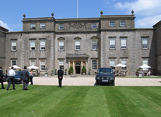
Ston Easton Park is an English country house built in the 18th century. It lies near the village of Ston Easton, Somerset. It is a Grade I listed building and the grounds are listed Grade II on the Register of Historic Parks and Gardens.

Englishcombe is a village and civil parish in Bath and North East Somerset just south-west of Bath, England. The parish, which also includes the hamlets of Inglesbatch and Nailwell, had a population of 318 at the 2011 census.

Sir Jacob William Rees-Mogg is a British politician, broadcaster and member of the Conservative Party who served as Member of Parliament (MP) for North East Somerset from 2010 to 2024. He served as Leader of the House of Commons and Lord President of the Council from 2019 to 2022, Minister of State for Brexit Opportunities and Government Efficiency from February to September 2022 and Secretary of State for Business, Energy and Industrial Strategy from September to October 2022. Rees-Mogg previously chaired the eurosceptic European Research Group (ERG) from 2018 to 2019 and has been associated with socially conservative views.
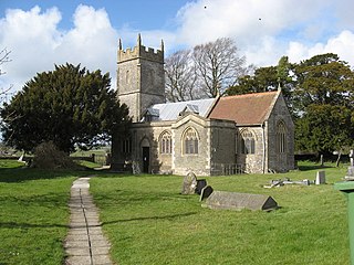
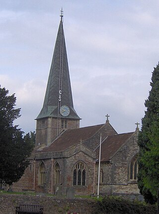
Ston Easton is a linear village and civil parish in the English county of Somerset. It is 14 miles (23 km) southwest of Bath and 7 miles (11 km) north of Shepton Mallet. It forms part of the Mendip district and lies along the A37 road 11 miles (18 km) south of the cities of Bristol and Bath and to the west of the town of Midsomer Norton. The parish includes the hamlet of Clapton.
The office of High Sheriff of Somerset is an ancient shrievalty which has been in existence since the 11th century. Originally known as the "Sheriff of Somerset", the role was retitled on 1 April 1974, under the provisions of the Local Government Act 1972.

The Grade I listed buildings in Somerset, England, demonstrate the history and diversity of its architecture. The ceremonial county of Somerset consists of a non-metropolitan county, administered by Somerset County Council, which is divided into five districts, and two unitary authorities. The districts of Somerset are West Somerset, South Somerset, Taunton Deane, Mendip and Sedgemoor. The two administratively independent unitary authorities, which were established on 1 April 1996 following the breakup of the county of Avon, are North Somerset and Bath and North East Somerset. These unitary authorities include areas that were once part of Somerset before the creation of Avon in 1974.
South Somerset is a local government district in the English county of Somerset. The South Somerset district occupies an area of 370 square miles (958 km2), stretching from its borders with Devon and Dorset to the edge of the Somerset Levels. The district has a population of about 158,000, and has Yeovil as its administrative centre.

Eastwood Manor Farm Steading in East Harptree, Somerset, England is a Grade I listed building.

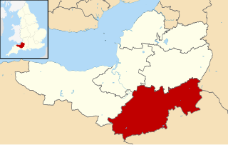
Bath and North East Somerset is a unitary authority created on 1 April 1996, following the abolition of the County of Avon, which had existed since 1974. Part of the ceremonial county of Somerset, Bath and North East Somerset occupies an area of 220 square miles (570 km2), two-thirds of which is green belt. It stretches from the outskirts of Bristol, south into the Mendip Hills and east to the southern Cotswold Hills and Wiltshire border. The city of Bath is the principal settlement in the district, but BANES also covers Keynsham, Midsomer Norton, Radstock and the Chew Valley. The area has a population of 170,000, about half of whom live in Bath, making it 12 times more densely populated than the rest of the area.
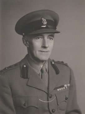
Colonel Sir Edward Geoffrey Hippisley-Cox was a British Army officer and parliamentary agent.

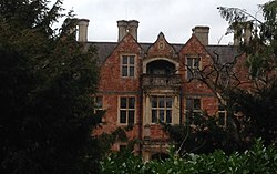
Cholwell is a historic hamlet and manor in the parish of Cameley, Somerset, England. The manor house, Cholwell House, was rebuilt in 1855 by William Rees-Mogg (1815-1909). It is a Grade II listed building.
Helena Anne Beatrice Wentworth Fitzwilliam de Chair, Lady Rees-Mogg, is a British heiress and television personality. She is married to Sir Jacob Rees-Mogg, the former Secretary of State for Business and Trade.