Ystrad Mynach is a town in the Caerphilly County Borough, within the ancient county of Glamorgan, Wales, and is 5 mi (8.0 km) north of the town of Caerphilly. The urban area has a population of 19,204, and stands in the Rhymney Valley. Before the Industrial Revolution and the coming of coal mining in the South Wales Coalfield the valley was rural and farmed. It lies in the community of Gelligaer.
Hengoed is a village on the west side of the Rhymney Valley - between Ystrad Mynach to the south and Cefn Hengoed to the north. Across the valley it looks towards Maesycwmmer. The village is in the county borough of Caerphilly, in the traditional county of Glamorgan, Wales.

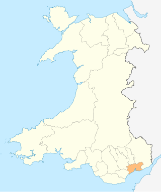
Pontllanfraith is a large village and community located in the Sirhowy Valley in Caerphilly County Borough, Wales, within the historic boundaries of Monmouthshire. It is situated adjacent to the town of Blackwood, with the Sirhowy River passing through both locations. The village includes the communities of the Penllwyn, Springfield and The Bryn. The population of the community at the 2011 census was 8,552.

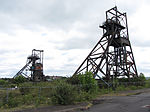
Penallta Colliery was a coal mine, located close to Hengoed in the Rhymney Valley in the South Wales Valleys. A coal mine which in 1935 held the European record for coal wound in a 24-hour period, it is now the site of an original redevelopment project which will make use of the former pit head buildings.

Great Western Mine, also known as Hetty Pit, was a coal mine, at Hopkinstown, near Pontypridd, Glamorgan in South Wales.

In the United Kingdom, the term listed building refers to a building or other structure officially designated as being of special architectural, historical, or cultural significance; Grade I structures are those considered to be "buildings of exceptional interest". Listing was begun by a provision in the Town and Country Planning Act 1947. Once listed, strict limitations are imposed on the modifications allowed to a building's structure or fittings. In Wales, the authority for listing under the Planning Act 1990 rests with Cadw.

In the United Kingdom, the term listed building refers to a building or other structure officially designated as being of special architectural, historical, or cultural significance; Grade I structures are those considered to be "buildings of exceptional interest". Listing was begun by a provision in the Town and Country Planning Act 1947. Once listed, strict limitations are imposed on the modifications allowed to a building's structure or fittings. In Wales, the authority for listing under the Planning Act 1990 rests with Cadw.
In the United Kingdom, the term listed building refers to a building or other structure officially designated as being of special architectural, historical, or cultural significance; Grade I structures are those considered to be "buildings of exceptional interest". Listing was begun by a provision in the Town and Country Planning Act 1947. Once listed, strict limitations are imposed on the modifications allowed to a building's structure or fittings. In Wales, the authority for listing under the Planning Act 1990 rests with Cadw.

In the United Kingdom, the term listed building refers to a building or other structure officially designated as being of special architectural, historical, or cultural significance; Grade I structures are those considered to be "buildings of exceptional interest". Listing was begun by a provision in the Town and Country Planning Act 1947. Once listed, strict limitations are imposed on the modifications allowed to a building's structure or fittings. In Wales, the authority for listing under the Planning Act 1990 rests with Cadw.

Rhondda Cynon Taf is a county borough in South Wales. It is located to the north-west of Cardiff and covers an area of 424 km2 (164 sq mi). In 2021 the population was approximately 237,500.

There are 33 Grade I listed buildings in the Vale of Glamorgan all of which are churches and priory buildings, castles, country or manor houses and associated structures such as churchyard crosses and a dovecote.

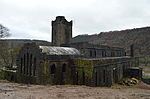
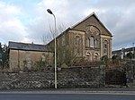
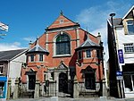
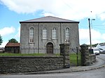
In the United Kingdom, the term listed building refers to a building or other structure officially designated as being of special architectural, historical, or cultural significance; Grade II* structures are those considered to be "particularly important buildings of more than special interest". Listing was begun by a provision in the Town and Country Planning Act 1947. Once listed, strict limitations are imposed on the modifications allowed to a building's structure or fittings. In Wales, the authority for listing under the Planning Act 1990 rests with Cadw.

In the United Kingdom, the term listed building refers to a building or other structure officially designated as being of special architectural, historical, or cultural significance; Grade II* structures are those considered to be "particularly important buildings of more than special interest". Listing was begun by a provision in the Town and Country Planning Act 1947. Once listed, strict limitations are imposed on the modifications allowed to a building's structure or fittings. In Wales, the authority for listing under the Planning Act 1990 rests with Cadw.

In the United Kingdom, the term listed building refers to a building or other structure officially designated as being of special architectural, historical, or cultural significance; Grade II* structures are those considered to be "particularly important buildings of more than special interest". Listing was begun by a provision in the Town and Country Planning Act 1947. Once listed, strict limitations are imposed on the modifications allowed to a building's structure or fittings. In Wales, the authority for listing under the Planning Act 1990 rests with Cadw.
Rhondda Cynon Taf is a county borough in South Wales. It is located to the north-west of Cardiff and covers an area of 424 km2 (164 sq mi). In 2021 the population was approximately 237,500.

In the United Kingdom, the term listed building refers to a building or other structure officially designated as being of special architectural, historical, or cultural significance; Grade II* structures are those considered to be "particularly important buildings of more than special interest". Listing was begun by a provision in the Town and Country Planning Act 1947. Once listed, strict limitations are imposed on the modifications allowed to a building's structure or fittings. In Wales, the authority for listing under the Planning Act 1990 rests with Cadw.

In the United Kingdom, the term listed building refers to a building or other structure officially designated as being of special architectural, historical, or cultural significance; Grade II* structures are those considered to be "particularly important buildings of more than special interest". Listing was begun by a provision in the Town and Country Planning Act 1947. Once listed, strict limitations are imposed on the modifications allowed to a building's structure or fittings. In Wales, the authority for listing under the Planning Act 1990 rests with Cadw.

In the United Kingdom, the term listed building refers to a building or other structure officially designated as being of special architectural, historical, or cultural significance; Grade II* structures are those considered to be "particularly important buildings of more than special interest". Listing was begun by a provision in the Town and Country Planning Act 1947. Once listed, strict limitations are imposed on the modifications allowed to a building's structure or fittings. In Wales, the authority for listing under the Planning Act 1990 rests with Cadw.

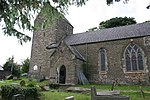
In the United Kingdom, the term listed building refers to a building or other structure officially designated as being of special architectural, historical, or cultural significance; Grade II structures are those considered to be "buildings of special interest which justify every effort being made to preserve them". Listing was begun by a provision in the Town and Country Planning Act 1947. Once listed, strict limitations are imposed on the modifications allowed to a building's structure or fittings. In Wales, the authority for listing under the Planning Act 1990 rests with Cadw.