
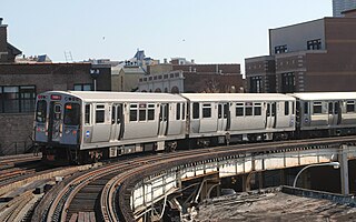
The Chicago "L" is the rapid transit system serving the city of Chicago and some of its surrounding suburbs in the U.S. state of Illinois. Operated by the Chicago Transit Authority (CTA), it is the fourth-largest rapid transit system in the United States in terms of total route length, at 102.8 miles (165.4 km) long as of 2014, and the third busiest rapid transit system in the United States, after the Washington Metro and New York City Subway. In 2016, the "L" had 1,492 rail cars, eight different routes, and 145 train stations. In 2022, the system had 103,524,900 rides, or about 322,200 per weekday in the first quarter of 2023.
The Red Line is a rapid transit line in Chicago, run by the Chicago Transit Authority (CTA) as part of the Chicago "L" system. It is the busiest line on the "L" system, with an average of 73,273 passengers boarding each weekday in 2021. The route is 26 miles (42 km) long with a total of 33 stations. It runs elevated from the Howard station in the Rogers Park neighborhood on the North Side, through a subway on the Near North Side, Downtown, and the South Loop, and then through the Dan Ryan Expressway median to 95th/Dan Ryan in the Roseland neighborhood on the South Side.

The Blue Line is a 26.93-mile-long (43.34 km) Chicago "L" line which extends through The Loop from O'Hare International Airport at the far northwest end of the city, through downtown via the Milwaukee–Dearborn subway and across the West Side to its southwest end at Forest Park, with a total of 33 stations. At about 27 miles, it is the longest line on the Chicago "L" system and second busiest, and one of the longest local subway/elevated lines in the world. It has an average of 47,120 passengers boarding each weekday in 2021.

The Green Line is a rapid transit line on the Chicago Transit Authority's "L" system. It is the only completely elevated route in the "L" system. All other routes may have various combinations of elevated, subway, street level, or freeway median sections.

The Chicago North Shore and Milwaukee Railroad, also known as the North Shore Line, was an interurban railroad that operated passenger and freight service over an 88.9-mile (143.1 km) route between the Chicago Loop and downtown Milwaukee, as well as an 8.6-mile (13.8 km) branch line between the villages of Lake Bluff and Mundelein, Illinois. The North Shore Line also provided streetcar, city bus and motor coach services along its interurban route.

Western Avenue is a street within the city of Chicago. Western Avenue extends south as a continuous road to the Dixie Highway at Sibley Boulevard in Dixmoor, giving the road a total length of 27.38 miles (44.06 km). Western Avenue, after turning into Asbury Ave, runs out on the north side at Green Bay Road in Evanston and on the south side at Crete-Monee Road in Crete. However, Western Avenue extends intermittently through the Southland to the Will/Kankakee county border in unincorporated Will Township. Within Chicago's grid street system, Western Avenue is 2400 West, three miles west of State Street.

The Pink Line is an 11.2 mi (18.0 km) rapid transit line in Chicago, run by the Chicago Transit Authority (CTA) as part of the Chicago "L" system. It is the CTA's newest rail line and began operation for a 180-day trial period on June 25, 2006, running between 54th/Cermak station in Cicero, Illinois and the Loop in downtown Chicago. The route, as the line is about to enter downtown Chicago, shares tracks with Green Line trains on Lake Street. This connection is handled by the previously non-revenue Paulina Connector set of tracks. In 2021, an average of 7,779 passengers boarded Pink Line trains on weekdays.
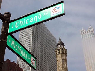
Chicago Avenue is a major east–west street in Chicago, Illinois that runs at 800 north from 385 east to 5968 west in the Chicago street address system from which point it enters the suburbs and goes into several different suburban address systems. It originates at the shores of Lake Michigan and Lake Shore Drive in the Gold Coast neighborhood in the Near North Side community area of Chicago in Cook County, Illinois, United States, and runs west to 17th Avenue, where it terminates a few feet north of Lake Street in Melrose Park, IL. This is a distance of approximately 12.2 miles (19.6 km).
Belmont Avenue is a major east–west street in Chicago and some suburbs. Belmont starts at the Belmont harbor area and is a central commercial street in Lakeview and, west of the North Branch of the Chicago River, Avondale. Further west, it anchors the Belmont-Central shopping district straddling the Belmont Cragin and Portage Park communities. The road enters western suburbs River Grove and Franklin Park before the main segment ends with other parts of Belmont still going west. Then west of the Cook County line parts of Belmont enter DuPage County, specifically in Bensenville and Addison, ending.

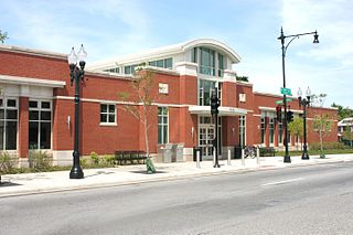
Austin is a station on the Chicago Transit Authority's 'L' system. It is located between the Ridgeland and Central stations on the Green Line, which runs from Harlem/Lake and to Ashland/63rd and Cottage Grove. The station is located at the intersection of Austin Boulevard and Corcoran Place in the Austin neighborhood on Chicago's West Side and borders the village of Oak Park.

Grand, is an "L" station on the CTA's Red Line. It serves Navy Pier, which is accessible via bus on Illinois Street one block south.
Cumberland is a station on the Chicago Transit Authority's 'L' system. Situated on the Blue Line between Rosemont and Harlem, the station is located in the median of the Kennedy Expressway at Cumberland Avenue in the O'Hare neighborhood on Chicago's Northwest Side. It is also in close proximity to both the Norwood Park neighborhood and the city of Park Ridge. The area surrounding the station consists of mixed commercial and residential development.

North Avenue is a major east–west street in Chicago, Illinois, and its western suburbs. Starting at St. Charles's eastern border with West Chicago, its name changes from Main Street to North Avenue, just east of the Kane/DuPage county line. From there, it travels straight east, carrying Illinois Route 64 until LaSalle Drive in Chicago. Illinois Route 64 then continues north onto LaSalle Drive for a very short distance until ending at U.S. Route 41, while North Avenue continues east for less than one-half mile, changing its name to North Boulevard at Clark Street, and then continuing until its termination in a cul-de-sac at 200 East, just west of Lake Shore Drive. From Illinois Route 43 to its east end, North Avenue is within the city limits of Chicago.
95th Street is a major east–west highway on Chicago's South Side and in the southwest suburbs, designated as 9500 South in Chicago's address system. 95th Street is 11 miles (18 km) south of Madison Street.
Cicero Avenue, also known as Skokie Boulevard in Skokie and Wilmette, is a major north–south street in Chicago and its suburbs in Cook and Will Counties. It carries Illinois Route 50 from its south end to Skokie, and U.S. Route 41 from Skokie to its north end. It runs north from the Governors Highway in University Park, next to Governors State University, crossing major highways such as Interstate 294, Interstate 55, Interstate 290 and Interstate 94, to Interstate 94 in Wilmette. Cicero Avenue is located 6 miles west of State Street.

Chicago, Illinois, is the third-largest city in the United States and a world transit hub. The area is served by two major airports, numerous highways, elevated/subway local train lines, and city/suburban commuter rail lines; it is the national passenger rail hub for Amtrak routes, and also the main freight rail hub of North America.

Sheffield Avenue is a north–south street in Chicago, Illinois. It is best known to sports fans as being the street just beyond the right-field bleachers of Wrigley Field.
Armitage Avenue is an east-west street in Chicago and its western suburbs, being located at 2000 North in the Chicago address system, two and one-half miles north of Madison Street. Its west end is located at President Street in the western suburb of Glendale Heights. In the western suburbs, it is a minor road, being split into many segments, usually by freeways. Armitage Avenue becomes a major street at its intersection with Grand Avenue in Chicago, continuing east until Mendell Street, just east of its interchange with Interstates 90 and 94, and just west of the North Branch of the Chicago River. Immediately east of the river, it resumes as a minor road, beginning at a cul-de-sac, heading east until Southport Avenue. At Racine Avenue, Armitage Avenue is once again a major street. From here, it continues east until its east end at Clark Street, just west of Lincoln Park.

Fullerton Avenue, known as Fullerton Parkway from its intersection with Halsted Street and Lincoln Avenue to its east end, is a major east–west street in Chicago and its western suburbs. Its west end is at Gary Avenue in Carol Stream. The road is split in many locations, usually because of freeways or railroads. Its east end is located at U.S. Route 41 in Chicago.

The Lake Street Elevated, also known as the Lake branch, is a 8.75 mi (14.08 km) long branch of the Chicago "L" which is located west of the Chicago Loop and serves the Green Line for its entire length, as well as the Pink Line east of Ashland Avenue. As of February 2013, the branch serves an average of 27,217 passengers each weekday. It serves the Near West Side, East Garfield Park, West Garfield Park, and Austin neighborhoods of Chicago, as well as the suburbs Oak Park and Forest Park. It owes its name to Lake Street, the street that the branch overlooks for 6.25 mi (10.06 km) before continuing its route straight west, adjacent to South Boulevard, towards the terminus at Harlem/Lake.
