Rush Street (Chicago)

Last updated

Rush Street
N Rush St Chicago.svg

20070913 Rush Street Bridge from Stamper's Book.JPG
Rush Street Bridge (1890)
RushSt(Chicago)map.svg
Maintained by Department of Streets & Sanitation
South end401 North at Kinzie/Water Streets (65 East)
Major
junctions
Chicago Avenue (800 North)

Ohio St./Ontario St. (east/westbound)

from/to Kennedy Expressway I-90.svgI-94.svg I-90  / I-94
North end1138 North at Cedar and State Streets (0 East)

Rush Street is a one-way street in the Near North Side community area of Chicago in Cook County, Illinois, United States. The street, which starts at the Chicago River between Wabash and North Michigan Avenues, runs directly north until it slants on a diagonal as it crosses Chicago Avenue then it continues to Cedar and State Streets, making it slightly less than a mile long. [1] One lane also runs southbound from Ohio Street (600N) to Kinzie Street (400N) as part of a two-way street segment. It runs parallel to and one block west of the Magnificent Mile on the two-way traffic North Michigan Avenue, which runs at 100 east up to 950 north. [2] The street, which is also one block east of the one-way southbound Wabash Avenue, formerly ran slightly further south to the Chicago River where over time various bridges connected it to the Loop, Chicago's central business district.

Contents

Rush Street's history traces back to the original incorporation of the city in the 1830s. It has since hosted important residences, such as the house of the first Mayor of Chicago, and significant commerce. [3] Today, it continues to run through some of the wealthiest neighborhoods in the country and has businesses that correspond to the demands of its residents. The neighborhood hosts highly rated restaurants, five-star hotels, and four-star spas. The street, which was named after Declaration of Independence signator Benjamin Rush, [1] was once known for its nightlife, especially at the northern end, which features entertainment that attracts locals and visitors. [4] [5] During the 1960s and 1970s, it was the most vibrant nightlife entertainment destination in the country outside of Las Vegas, with major stars like Tony Bennett, Frank Sinatra, Barry Manilow. Bette Midler, Oscar Peterson, to name a few, along with some of the greatest groups to hail from the city of Chicago. By the 1980s many of these establishments shuttered. Today, the street has emerged into an overflow of Oak Street with luxury shopping lining the streets from Barney's to Bugatti. The southern end of the street was an integral part of the city as a main river crossing at various incarnations of the Rush Street Bridge across the main branch of the Chicago River from the mid-19th century until the 1920s. [6] [7] The Rush Street Bridges have a rich cultural history, which includes both a prominent role in facilitating vehicular land traffic and a prominent role as a commercial port location. However, commerce on the Chicago River has declined since the 1930s and the Michigan Avenue Bridge has taken over the role as the primary river crossing for this neighborhood. [8]

Background

Benjamin Rush by Charles Willson Peale, 1783 Benjamin Rush Painting by Peale 1783.jpg
Benjamin Rush by Charles Willson Peale, 1783

Rush Street was named after Benjamin Rush, one of the four physician signators of the United States Declaration of Independence. It is one of several places named after Rush in Chicago; other such places are Rush Medical College and Rush-Presbyterian-St. Luke's Medical Center. [1]

As part of the original incorporated city of Chicago in 1837, [9] Rush Street is one of the city's oldest thoroughfares. [3] Like Clark Street, parts of Rush Street roughly follow the path of an Indian trail called Green Bay trail (later Green Bay Road) that ran to Green Bay, Wisconsin. [10] Early Rush Street was commonly agreed to be desirable place of residence, and hosted the first house designed by an architect in Chicago (designed for the first Mayor of Chicago William Ogden by John M. Van Osdel). [3] The house, bounded by Erie, Ontario, Rush and Cass (now Wabash Avenue) Streets, did not survive the Great Chicago Fire of 1871.

After the Great Chicago Fire, the Near North Side became a refuge for many due to its wide streets, high ground, good drainage, and proximity to both the Lake Michigan lakeshore and Lincoln Park. Cyrus McCormick built a mansion at 675 Rush Street between 1875 and 1879. [11] The mansion, located at the corner of Rush and Erie, lured so many relatives to move nearby that the neighborhood became known as "McCormickville" by the 1880s. [12] [13] The street subsequently hosted elite Chicago socialites. [13] Cyrus' brother Leander J. McCormick built the Virginia Hotel at the northwest corner of Rush and Ohio. 41°53′32″N87°37′31″W / 41.89222°N 87.62528°W / 41.89222; -87.62528 (Rush Street at Ohio) Opening just a few years before the 1893 World's Columbian Exposition, the 400-room hotel was advertised as "an absolutely fire-proof building and a finished hotel second to no other." [14] The hotel featured ornate granite interiors decorated with marble statues, separate "gentlemen's smoking room" and "ladies dining room", and a room of boilers and dynamos to offer the latest technology: electric lights. [14] Well into the 20th century, residential buildings faced Rush Street until the demands of the expanding commerce—especially concentrations of restaurants and night clubs—consumed its real estate. [15]

Intersections
20080514 Rush-State-Cedar.JPG
Endpoint at State Street (2008-05-14)
20080514 Rush-Wabash.JPG
Wabash intersection (2008-05-14)
200805114 Rush-Ohio intersetion.JPG
One-way traffic begins at Ohio Street
20080514 Sinatra Way at Rush Street.JPG
Frank Sinatra Way intersection (2008-05-14)
20070728 Ohio Street & Michigan Avenue from Rush Street.jpg
Magnificent Mile's Michigan Ave. from Rush & Ohio Streets (2007-07-28)
Chicago nightscape, from far above Michigan Avenue at Rush Street.jpg
Aon Center, Tribune Tower, NBC Tower, et al. from Rush & Ohio Streets (2007-07-28)
20080514 Connors Park2.JPG
Connors Park (2008-05-14)
20080514 Mariano Park.JPG
Mariano Park (2008-05-14)
Rush Street views
20080514 Street view with carriage.JPG
Street view with carriage traffic (2008-05-14)
20080514 Mike Ditka Way crosses Rush St. in front of The Clare.JPG
Chestnut St (Mike Ditka Way) intersection (2008-05-14)
20080514 Rush-State sign.JPG
Rush Street-State Street sign
20080514 Connors Park.JPG
Connors Park (2008-05-14)
Foot of Rush Street
20080514 Foot of Rush from across Chicago River.JPG
Foot of Rush St. from across Chicago River
20080514 Foot of Rush Street & 55 East Erie.JPG
View from foot of Rush Street
Michigan Ave Bridge 060415.jpg
Foot of Rush Street from beyond Michigan Avenue Bridge

In the 1950s, the Chicago City Council began to use the Uniform Vehicle Code of 1931 to fight traffic congestion by creating one-way streets. This was most effectively used in the Loop and Near North Side community areas. [16] Most of the Near North Side streets remain one-way today as a result. Rush Street is among the area's one-way streets: except for a short segment, only northbound travel is permitted. [17]

Geography

Rush Street runs north–south and in a north-northwest direction (see map in external links). It runs north–south at 65 east from 400 north at its southern terminus at Kinzie Avenue to 800 north at Chicago Avenue between Michigan Avenue to the east at 100 east and Wabash Avenue to the west at 44 east. On the north side of Chicago it runs straight on a slight diagonal to the street grid. By the time it travels three blocks north to Delaware Place at 900 north, it intersects Wabash. [18] It then continues on a diagonal for four more blocks where it intersects the north–south running State Street (the centerline between east and west) [19] at Cedar Street which runs at 1120 north. [20] It is crossed by Ohio Street and Ontario Street which feed from and to the Kennedy Expressway to the west. [17]

On the north side of Chicago Avenue Rush Street is part of the Gold Coast neighborhood of the Near North Side community area. The Gold Coast is the nation's second wealthiest neighborhood, trailing only the Central Park East neighborhood of Manhattan's Upper East Side. [21] Between Chicago Avenue and the Chicago River, Rush Street is part of the River North Gallery District. The River North District hosts more art galleries than any neighborhood outside of Manhattan. [22]

Both of the diagonal crossings border Chicago Park District parks that are situated on the resulting triangular land plots. At the Wabash crossing, which has an official address of 871 North Wabash, a park exists that was renamed Connors Park for former Illinois State Senate Minority Leader William Connors in 1970. This park was acquired by the city in 1848 and has been renamed several times. [23] At the State Street crossing, which has an official address of 1031 North State Street, Mariano Park exists and was renamed for Louis Mariano in 1970. This park was acquired by the city in 1848 and was transferred to the Park District in 1959. [24] It hosts a structure designed by Birch Burdette Long, who was a Frank Lloyd Wright protege, according to a plaque in the park. In the area surrounded by the Trump International Hotel & Tower to the west, the Chicago River to the south, Rush Street and the Wrigley Building to the east and McDonald's and River Plaza to the north the towers designers have planned a 1.2-acre (4,856.2 m2) Riverfront Park & Riverwalk along a space that is 500 feet (152.4 m). [25]

In the Gold Coast neighborhood, honorary streets such as Frank Sinatra Way (Bellevue Place at 1030 north) [26] and Mike Ditka Way (East Chesnut Street at 860 north) [27] cross Rush Street. Ditka has a restaurant at 100 East Chestnut and coached the Chicago Bears to a Super Bowl XX victory. [28] Sinatra made "My Kind of Town (Chicago is)" and "Chicago (That Toddlin' Town)" famous.

Bridge

Rush Street Bridge
Dock after 1904 auto accident.jpg
Rush Street Bridge accident scene (1904)
Manitou arriving at Rush Street Bridge.jpg
Manitou arriving at Rush Street Bridge (1915)
Rush St Bridge.jpg
New Rush Street Bridge, Opening Day (1920)
SS Christopher Columbus moored at Rush Street Bridge.jpg
SS Christopher Columbus - Rush St. Bridge (1915)
Wrigley Building with the Rush Street Bridge (1921) 20070913 Rush Street Swing Bridge beyond Wrigley Building.JPG
Wrigley Building with the Rush Street Bridge (1921)

While there is currently no bridge along Rush Street at the main stem of the Chicago River, the main stem has through its history been crossed by four bridges at Rush Street. The first bridge was a floating bridge that was hinged to one bank. Ropes were used to open and close this bridge. [6] A March 1849 ice storm was the first of two instances in which all bridges on the main stem of the Chicago River were destroyed overnight. An iron and timber swing bridge with center supports was built in 1857 at a cost of $48,000. The bridge stood until, on November 3, 1863, a passing ship's whistle spooked a herd of cattle that was crowding the bridge and stampeded into the river. [7] The bridge was repaired and still in use on October 8, 1871 when it was destroyed in the Great Chicago Fire. In 1872 the Detroit Bridge and Iron Works company built a wrought-iron replacement that stood until 1883, when a barge struck and collapsed the bridge. [6] It was replaced by another swing bridge that lasted for several decades until after the Michigan Avenue Bridge was built in 1920. [7] This final 1884 bridge had trusses measuring 30 feet (9.1 m) in the center and 20 feet (6.1 m) on the ends. Its deck used 4-inch (100 mm) white pine planks. [6]

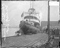
The southeast corner of the Rush Street Bridge, which connected to Michigan Avenue, was the location of the Goodrich docks from which the SS Christopher Columbus made its daily round-trip excursions to Milwaukee, Wisconsin. [15] Although she was used for excursions elsewhere around the Great Lakes, her regular schedule was a daily trip to Milwaukee, leaving Chicago mid-morning, sailing to Milwaukee for a two-hour stopover, and then returning. [29] The Goodrich Transportation Company used the Goodrich wharves from the time of the American Civil War until the 1930s to connect Chicago with other port locations throughout Lake Michigan and the Great Lakes. [15] Today, skyscrapers have replaced the industrial structures that historically lined the riverbanks of the nations most significant inland port. [15] [30]

Before the Michigan Avenue bridge (pictured right), vehicular traffic crossed the river at Rush and traveled up to Ontario Street before heading east to Pine Street (now North Michigan Avenue after multiple renamings). [31] The bridge carried 77% of all the automobiles and 23% of the commercial vehicles that commuted into the Loop each day. [32] There were several plans starting in the 1880s for improving Michigan Avenue that involved Rush Street, but nothing came of any of them. [33] The final Rush Street Bridge was not designed for automobile traffic, which caused congestion on the south bank of the River where both Michigan and Wabash fed onto River Street (now Wacker Drive). In May 1904, the Chicago Tribune declared that the 36 feet (11 m) wide Rush Street Bridge, which handled approximately 50% of the north–south traffic in the city, was unfit for the contemporary pedestrian and vehicular traffic. [34] Thus Daniel Burnham's 1909 Plan of Chicago called for the replacement of the bridge with a new bridge at Michigan Avenue and the redevelopment of Wacker Drive. The bridge was quickly removed after the completion of the new Michigan Avenue Bridge. [8]

Commerce and education

20070912 Gibson's Steakhouse.JPG
20070912 Bentley Showroom.JPG
Quigley Seminary.jpg
20070729 Giordano's.jpg
20080514 Conrad Hotel.JPG
Left to Right: Gibsons Steakhouse, Bentley/Lamborghini Showroom, Archbishop Quigley Preparatory Seminary, Giordano's, and the Conrad Hotel.
20070914 Trump International Hotel & Tower - Chicago.JPG
20070729 Rosebud on Rush.jpg
20080116 The Clare @ The Water Tower.jpg
20040502 Hancock Center from Rush St..jpg
Left to right: Trump Tower Chicago (9-14-07), Rosebud on Rush (7-29-07), The Clare @ Water Tower (1-16-08), Hancock Center from Rush Street (5-02-04), and 55 East Erie Street from walkway over Rush St. start (5-14-08)

In the 1960s, Rush Street was the center of the Chicago nightlife as home to many great cabarets, bars, clubs and restaurants. [4] However, many of the bars migrated north to Division Street as the street gentrified. [4] Currently, the late night establishments mostly lure suburbanites and tourists. [5] The Chicago Sun-Times describes it as the "hippest strip" in Chicago, with specific kudos to the part between Oak Street and Chicago Avenue. [35] It continues to be the destination where visiting conventioners in pursuit of Chicago nightlife are brought by taxi as well as a preferred place for thirtysomething singles to congregate at night, especially in the summer. [36] [37] Although Rush Street ends two blocks south of Division Street, the nightlife ambiance now continues to Division and spreads west from there.

Rush Street is known for hosting some of the few highly rated and esteemed restaurants in the Chicago Gold Coast neighborhood. [36] According to Frommer's and Zagat Survey, Gibsons Steakhouse is one of the favorite restaurants in Chicago, [38] [39] and is located on Rush Street. Rush Street is a block east of the original location of the Chicago-style deep dish pizza, Uno Chicago Grill, [40] and it hosts Giordano's, its answer to Uno's. Among the most prominent businesses along this strip is the Bentley and Lamborghini Gold Coast showroom, [35] which is located across East Pearson Street from The Clare at Water Tower along Rush Street. The Clare is one of the tallest residential buildings reserved for seniors anywhere in the world. [41] Rush Street's southern terminus is adjacent to a rear entrance of the Wrigley Building as well as the Trump International Hotel and Tower which has a 401-North Wabash address. [42] The 800 block of the Gold Coast neighborhood portion of Rush Street is a block away from Michigan Avenue and four of the tallest buildings in the world: John Hancock Center (875 North Michigan Avenue), 900 North Michigan, Water Tower Place (845 Michigan), & Park Tower (800 Michigan). Four more of the fifty tallest buildings in Chicago are also a block from Rush Street: Olympia Centre (737 Michigan), One Magnificent Mile, (980 Michigan), Chicago Place (700 Michigan), and Palmolive Building, (919 Michigan). 55 East Erie Street, which was the second tallest all-residential building in the world from 2004 until 2007 when 340 on the Park was completed, [43] is among the skyscrapers on or with entrances on Rush street. There is a current proposal to redevelop 740 North Rush Street (at the corner of East Superior Street) with a fifty-story skyscraper designed by Skidmore, Owings & Merrill and developed by Fordham Company. [44] This address currently houses the Chicago offices of Crain Communications Inc., and it is just north of Giordano's, which has a 730 North Rush Street address.

Several prominent hotels are located on or bounded by Rush street. The Peninsula Chicago is one of only three five star hotels in the Midwestern United States, [45] is located on East Superior between Rush Street and Michigan. [46] The Four Seasons Hotel Chicago, another of the Midwest's five star hotels, [45] is also located on a cross street between Rush Street and Michigan Avenue. [47] These two hotels host the highest rated spas in Illinois. [48] Although the main entrance and official address of the Chicago Marriott Downtown Magnificent Mile is 540 North Michigan Avenue, the driveway for the hotel has a 541 North Rush Street address. [49] Similarly, the former Chicago Conrad Hotel (since 2015, The Gwen) located at 521 North Rush Street is a reconstruction of the former 520 North Michigan Chicago Landmark McGraw-Hill Building. [50]

The former Archbishop Quigley Preparatory Seminary, which has been converted for use by the Roman Catholic Archdiocese of Chicago is located on Rush Street between Superior and Chestnut. The Water Tower Campus of the Loyola University Chicago is located along East Pearson St., which crosses Rush Street between the Bentley/Lamborghini Gold Coast Showroom to the North and The Clare @ Water Tower to the South on the west side of the street. [51] The Quigley Seminary Building was listed on the National Register of Historic Places on February 16, 1996. Rush Street also hosts one of three regional Royal Thai Consulate-General locations to support Royal Thai Embassy in Washington, D.C. [52]

Intersections

The entire route is in Chicago, Cook County.

mi [53] kmDestinationsNotes
0.000.00North State Street/East Cedar StreetNorthern terminus
0.060.097East Bellevue Place
0.120.19East Oak Street
0.180.29East Walton StreetOne-way westbound only
0.240.39East Delaware PlaceOne-way eastbound only
0.300.48East Chestnut StreetOne-way westbound only
0.360.58East Pearson StreetOne-way eastbound only
0.420.68East Chicago Avenue
0.480.77East Superior StreetOne-way eastbound only
0.540.87East Superior StreetOne-way eastbound only
0.600.97East Erie StreetOne-way eastbound only
0.651.05East Ontario StreetOne-way westbound only
0.701.13East Ohio Street One-way eastbound only
0.761.22East Grand Avenue One-way westbound only
0.811.30East Illinois StreetOne-way eastbound only
0.871.40East Hubbard Street
0.911.46East Kinzie Street/East North Water Street
1.000 mi = 1.609 km; 1.000 km = 0.621 mi

See also

Related Research Articles

<span class="mw-page-title-main">Chicago River</span> System of rivers and canals running through the city of Chicago

The Chicago River is a system of rivers and canals with a combined length of 156 miles (251 km) that runs through the city of Chicago, including its center. Though not especially long, the river is notable because it is one of the reasons for Chicago's geographic importance: the related Chicago Portage is a link between the Great Lakes and the Mississippi River Basin, and ultimately the Gulf of Mexico.

<span class="mw-page-title-main">Chicago Loop</span> Community area in Chicago

The Loop, one of Chicago's 77 designated community areas, is the central business district of the city and is the main section of Downtown Chicago. Home to Chicago's commercial core, it is the second largest commercial business district in North America and contains the headquarters and regional offices of several global and national businesses, retail establishments, restaurants, hotels, and theaters, as well as many of Chicago's most famous attractions. It is home to Chicago's City Hall, the seat of Cook County, and numerous offices of other levels of government and consulates of foreign nations. The intersection of State Street and Madison Street is the origin point for the address system on Chicago's street grid. Most of Grant Park's 319 acres (1.29 km2) are in the eastern section of the community area. The Loop community area is bounded on the north and west by the Chicago River, on the east by Lake Michigan, and on the south by Roosevelt Road.

<span class="mw-page-title-main">Michigan Avenue (Chicago)</span> Major north-south thoroughfare in Chicago, Illinois, United States

Michigan Avenue is a north-south street in Chicago that runs at 100 east on the Chicago grid. The northern end of the street is at Lake Shore Drive on the shore of Lake Michigan in the Gold Coast Historic District. The street's southern terminus is at Sibley Boulevard in the southern suburb of Dolton, but like many other Chicago streets, it exists in several disjointed segments.

<span class="mw-page-title-main">Green Line (CTA)</span> Rapid transit line, part of the Chicago L system

The Green Line is a rapid transit line in Chicago, Illinois, operated by the Chicago Transit Authority (CTA) as part of the Chicago "L" system. It is the only completely elevated route in the "L" system. All other routes may have various combinations of elevated, subway, street level, or freeway median sections.

<span class="mw-page-title-main">Streeterville</span> Neighborhood in Chicago

Streeterville is a neighborhood in the Near North Side community area of Chicago, Illinois, United States, north of the Chicago River. It is bounded by the river on the south, the Magnificent Mile portion of Michigan Avenue on the west, and Lake Michigan on the north and east, according to most sources, although the City of Chicago only recognizes a small portion of this region as Streeterville. Thus, it can be described as the Magnificent Mile plus all land east of it. The tourist attraction of Navy Pier and Ohio Street Beach extend out into the lake from southern Streeterville. To the north, the East Lake Shore Drive District, where the Drive curves around the shoreline, may be considered an extension the Gold Coast. The majority of the land in this neighborhood is reclaimed sandbar.

<span class="mw-page-title-main">Trump International Hotel and Tower (Chicago)</span> Supertall skyscraper condo-hotel in downtown Chicago, Illinois

The Trump International Hotel and Tower is a skyscraper condo-hotel in downtown Chicago, Illinois. The building, named for Donald Trump, was designed by architect Adrian Smith of Skidmore, Owings and Merrill. Bovis Lend Lease built the 100-story structure, which reaches a height of 1,388 feet (423.2 m) including its spire, its roof topping out at 1,171 feet (357 m). It is next to the main branch of the Chicago River, with a view of the entry to Lake Michigan beyond a series of bridges over the river. The building received publicity when the winner of the first season of The Apprentice reality television show, Bill Rancic, chose to manage the construction of the tower over managing a Rancho Palos Verdes based "Trump National Golf Course & Resort" in the Los Angeles metro area.

<span class="mw-page-title-main">Near North Side, Chicago</span> Community area in Chicago

The Near North Side is the eighth of Chicago's 77 community areas. It is the northernmost of the three areas that constitute central Chicago, the others being the Loop and the Near South Side. The community area is located north and east of the Chicago River. To its east is Lake Michigan, and its northern boundary is the early 19th-century city limit of Chicago, North Avenue. In 2020 the Near North Side had 105,481 residents, surpassing Lake View as the largest Chicago community area by population. It is also the most densely populated community area and has the second most skyscrapers, after the Loop. With the exception of Goose Island, the Near North Side is known for its extreme affluence, typified by the Gold Coast, Magnificent Mile, Navy Pier, and skyscrapers.

<span class="mw-page-title-main">Near South Side, Chicago</span> Community area in Chicago

The Near South Side is a community area of Chicago, Illinois, United States, just south of the downtown central business district, the Loop. The Near South Side's boundaries are as follows: North—Roosevelt Road ; South—26th Street; West—Chicago River between Roosevelt and 18th Street, Clark Street between 18th Street and Cermak Road, Federal between Cermak Road and the Stevenson Expressway just south of 25th Street, and Clark Street again between the Stevenson and 26th Street; and East—Lake Michigan.

<span class="mw-page-title-main">Wacker Drive</span> Major street in Chicago, Illinois

Wacker Drive is a major multilevel street in Chicago, Illinois, running along the south side of the main branch and the east side of the south branch of the Chicago River in the Loop. The vast majority of the street is double-decked; the upper level intended for local traffic, and the lower level for through-traffic and trucks serving buildings on the road. It is sometimes cited as a precursor to the freeway, though when it was built the idea was that pleasure vehicles would use the upper level. It is the only street in the city that is prefixed with all four cardinal directions, albeit on different parts of its route. The drive is named for early 20th century Chicago businessman and city planner Charles H. Wacker.

<span class="mw-page-title-main">Magnificent Mile</span> Neighborhood and street in Cook, Illinois, United States

The Magnificent Mile, sometimes referred to as The Mag Mile, is an upscale section of Chicago's Michigan Avenue, running from the Chicago River to Oak Street in the Near North Side. The district is located within downtown and one block east of Rush Street. The Magnificent Mile serves as the main thoroughfare between Chicago's Loop business district and its Gold Coast. It is generally the western boundary of the Streeterville neighborhood, to its east, and of River North to the west.

<span class="mw-page-title-main">Multilevel streets in Chicago</span> Tiered streets

Downtown Chicago, Illinois, has some double-decked and a few triple-decked streets immediately north and south of the Main Branch and immediately east of the South Branch of the Chicago River. The most famous and longest of these is Wacker Drive, which replaced the South Water Street Market upon its 1926 completion. The resulting bi-level street has an upper-level riverfront boulevard, a lower-level roadway for commercial and through traffic, and a recreational walkway at water level.

<span class="mw-page-title-main">River North Gallery District, Near North Side, Chicago</span> District of Chicago, Illinois, USA

The River North Gallery District or simply River North, in Chicago, is in the Near North Side, Chicago. It once hosted the largest concentration of art galleries in the United States outside of Manhattan. River North has experienced vast changes in the years 1990 - 2012, including the development of large high-rise buildings, nightclubs and restaurants. River North has become one of Chicago's top neighborhoods for nightlife especially on and around Hubbard Street.Today there are far fewer galleries but the artistic spirit remains, with regular art openings taking place as well as a Fall River North Design District Walk taking place every September.

<span class="mw-page-title-main">DuSable Bridge</span> Bridge in Chicago, Illinois

The DuSable Bridge is a bascule bridge that carries Michigan Avenue across the main stem of the Chicago River in downtown Chicago, Illinois, United States. The bridge was proposed in the early 20th century as part of a plan to link Grant Park (downtown) and Lincoln Park (uptown) with a grand boulevard. Construction of the bridge started in 1918, it opened to traffic in 1920, and decorative work was completed in 1928. The bridge provides passage for vehicles and pedestrians on two levels. An example of a fixed trunnion bascule bridge, it may be raised to allow tall ships and boats to pass underneath. The bridge is included in the Michigan–Wacker Historic District and has been designated as a Chicago Landmark.

The Shops at North Bridge, once known as Westfield North Bridge, is an upscale, urban retail-entertainment district in Chicago, Illinois, located at 520 N. Michigan Avenue. Its anchor store is Nordstrom. Its name alludes first to its location within the nine-block North Bridge complex and to the literal distinction of the shopping center incorporating four-level enclosed bridges over both east Grand Ave, and north Rush Street.

<span class="mw-page-title-main">Chicago Avenue</span>

Chicago Avenue is a major east–west street in Chicago, Illinois that runs at 800 north from 385 east to 5968 west in the Chicago street address system from which point it enters the suburbs and goes into several different suburban address systems. It originates at the shores of Lake Michigan and Lake Shore Drive in the Gold Coast neighborhood in the Near North Side community area of Chicago in Cook County, Illinois, United States, and runs west to 17th Avenue, where it terminates a few feet north of Lake Street in Melrose Park, IL. This is a distance of approximately 12.2 miles (19.6 km).

<span class="mw-page-title-main">Clark Street (Chicago)</span> Major north–south thoroughfare in Chicago, Illinois, United States

Clark Street is a north–south street in Chicago, Illinois that runs close to the shore of Lake Michigan from the northern city boundary with Evanston, to 2200 South in the city street numbering system. At its northern end, Clark Street is at 1800 West; however the street runs diagonally through the Chicago grid for about 8 miles (13 km) to North Avenue and then runs at 100 West for the rest of its course south to Cermak Road. It is also seen in Riverdale beyond 127th street across the Calumet River, along with other nearby streets that ended just south of the Loop. The major length of Clark Street runs a total of 98 blocks.

<span class="mw-page-title-main">Historic Michigan Boulevard District</span> Historic district of Chicago, Illinois, United States

The Historic Michigan Boulevard District is a historic district in the Loop community area of Chicago in Cook County, Illinois, United States encompassing Michigan Avenue between 11th or Roosevelt Road, depending on the source, and Randolph Streets and named after the nearby Lake Michigan. It was designated a Chicago Landmark on February 27, 2002. The district includes numerous significant buildings on Michigan Avenue facing Grant Park. In addition, this section of Michigan Avenue includes the point recognized as the end of U.S. Route 66. This district is one of the world's best known one-sided streets rivalling Fifth Avenue in New York City and Edinburgh's Princes Street. It lies immediately south of the Michigan–Wacker Historic District and east of the Loop Retail Historic District.

<span class="mw-page-title-main">Michigan–Wacker Historic District</span> Historic district in Illinois, United States

The Michigan–Wacker Historic District is a National Register of Historic Places District that includes parts of the Chicago Loop and Near North Side community areas in Chicago, Illinois, United States. The district is known for the Chicago River, two bridges that cross it, and eleven high rise and skyscraper buildings erected in the 1920s. Among the contributing properties are the following Chicago Landmark structures:

<span class="mw-page-title-main">Prairie Avenue</span> Thoroughfare in Chicago, United States

Prairie Avenue is a north–south street on the South Side of Chicago, which historically extended from 16th Street in the Near South Side to the city's southern limits and beyond. The street has a rich history from its origins as a major trail for horseback riders and carriages. During the last three decades of the 19th century, a six-block section of the street served as the residence of many of Chicago's elite families and an additional four-block section was also known for grand homes. The upper six-block section includes part of the historic Prairie Avenue District, which was declared a Chicago Landmark and added to the National Register of Historic Places.

References

  1. 1 2 3 Hayner, Don & McNamee, Tom (1988). "Rush Street". Streetwise Chicago. Chicago: Loyola University Press. p. 112. ISBN   0-8294-0597-6.
  2. Hayner & McNamee (1988) , "Michigan Avenue/Michigan Avenue (Pvt.)", p. 87.
  3. 1 2 3 Clark, Herma (1952). Let's Walk Along Rush Street. Chicago: Tribune Company. p. 3. OCLC   18947366.
  4. 1 2 3 Blackwell, Elizabeth Canning (2007). Frommer's Irreverent Guide to Chicago (6th ed.). Hoboken, NJ: Wiley Publishing. p. 167. ISBN   978-0-470-04079-9.
  5. 1 2 "Chicago: The Lounge & Bar Scene". Frommer's. Wiley Publishing, Inc. 2007. Retrieved September 12, 2007.
  6. 1 2 3 4 Stamper, John W. (1991). Chicago's North Michigan Avenue: Planning and Development, 1900-1930. Chicago: University of Chicago Press. p. 243. ISBN   0-226-77085-0.
  7. 1 2 3 "City of Bridges: Rush Street Bridges". Electronic Encyclopedia of Chicago. Chicago: Chicago Historical Society. 2005. p. 1. Retrieved September 12, 2007.
  8. 1 2 "City of Bridges: Rush Street Bridges". Electronic Encyclopedia of Chicago. Chicago: Chicago Historical Society. 2005. p. 2. Retrieved September 12, 2007.
  9. Chicago Fact Book Consortium, ed. (1995). Local Community Fact Book Chicago Metropolitan Area 1990. Chicago: University of Illinois at Chicago. p. 57. ISBN   0-914091-60-3.
  10. Quaife, Milo Milton (1923). Chicago's Highways, Old and New: From Indian Trail to Motor Road. D.F. Keller & Company. pp.  106–107. OCLC   1686569 . Retrieved August 22, 2010.
  11. Clark (1952) , p. 8.
  12. Stamper (1991) , p. xix.
  13. 1 2 Clark (1952) , p. 6.
  14. 1 2 The Virginia Hotel, Chicago. Chicago: Press of J.C. Winship & Company. 1893. OCLC   38069569.
  15. 1 2 3 4 Mayer, Harold M. & Wade, Richard C. (1969). Chicago: Growth of a Metropolis . Chicago: University of Chicago Press. ISBN   0-226-51274-6.
  16. Miller, Christopher (2005). "Streets, One-Way". The Electronic Encyclopedia of Chicago. Chicago: Chicago Historical Society. Retrieved September 24, 2007.
  17. 1 2 Google (September 24, 2007). "700 North Rush Street" (Map). Google Maps . Google. Retrieved September 24, 2007.
  18. Hayner & McNamee (1988) , "Delaware Place", p. 31.
  19. Hayner & McNamee (1988) , "State Street", p. 120.
  20. Hayner & McNamee (1988) , "Cedar Street", p. 21.
  21. Kogan, Rick & Reardon, Patrick T. (December 5, 1999). "Be it Ever So Affluent ... For Those Who Call it Home, There's No Place Like The Gold Coast". Chicago Tribune . Retrieved May 8, 2008.
  22. "From Greektown to Bronzeville, Chicago's Welcome Mats Are Out". Bank of America Chicago Marathon. Archived from the original on June 4, 2008. Retrieved May 8, 2008.
  23. "Connors Park". Chicago Park District. 2006. Archived from the original on June 5, 2008. Retrieved May 14, 2008.
  24. "Mariano Park". Chicago Park District. 2006. Archived from the original on June 5, 2008. Retrieved May 14, 2008.
  25. "Project Overview" (PDF). Trump Organization. Archived from the original (PDF) on May 28, 2008. Retrieved May 18, 2008.
  26. Hayner & McNamee (1988) , "Bellevue Place", p. 10.
  27. Hayner & McNamee (1988) , "Cedar Street", p.22.
  28. "Mike Ditka's". Mike Ditka’s Restaurants. Retrieved May 15, 2008.
  29. Reilly, Michael R. (May 11, 2007) [1995]. "Joseph Schlitz Brewing Co.: A Chronological History 1881–1907". Archived from the original on August 7, 2007. Retrieved October 19, 2007.
  30. McNulty, Elizabeth (2000). Chicago Then and Now. San Diego: Thunder Bay Press. ISBN   1-57145-278-8.[ page needed ]
  31. Clark (1952) , p. 4.
  32. Edgerton, Michael & Heise, Kenan. Chicago Center for Enterprise. Vol. II. Windsor Publications. ISBN   0-89781-041-4.
  33. Stamper (1991) , p. 2.
  34. Stamper (1991) , pp. 3–4.
  35. 1 2 Thomas, Mike (November 11, 2005). "Rush Street". Chicago Sun-Times. Archived from the original on September 22, 2007. Retrieved September 12, 2007.
  36. 1 2 Dale, Alzina Stone (1995). "Gold Coast Walk". Mystery Reader's Walking Guide: Chicago. Lincolnwood, IL: Passport Books. pp.  173–6. ISBN   0-8442-9607-4.
  37. McHugh, Rich; Anderson, J.P. & Lascom, Carolin, eds. (2006). The Rough Guide to Chicago (2nd ed.). London: Rough Guides. ISBN   1-84353-615-3.
  38. "Zagat Chicago". Zagat Survey. 2005. Archived from the original on June 5, 2008. Retrieved September 12, 2007.
  39. "Best Dining Bets". Frommer's. Wiley Publishing, Inc. Retrieved May 12, 2008.
  40. "Pizzeria Uno". Frommer's. Wiley Publishing, Inc. Retrieved May 12, 2008.
  41. Adler, Jane (August 20, 2006). "The Clare takes a vertical approach to senior living". Chicago Tribune . Retrieved May 13, 2008.
  42. Clark (1952) , p. 11.
  43. "56-storey residential tower with self-climbing formwork" (PDF). International Site Review. Formwork News. January 2003. Archived from the original (PDF) on November 23, 2008. Retrieved May 15, 2008.
  44. "740 North Rush". Emporis.com. Archived from the original on October 19, 2012. Retrieved May 18, 2008.
  45. 1 2 "Mobil Travel Guide's 50th Annual Star Awards: Five-Star Hotels". Mobil Travel Guide. Archived from the original on March 4, 2008. Retrieved May 21, 2008.
  46. "The Peninsula: Chicago". Archived from the original on June 4, 2008. Retrieved May 21, 2008.
  47. "Directions and Map". Four Seasons Hotel Chicago. Retrieved May 21, 2008.
  48. "Mobil Travel Guide's 50th Annual Star Awards: Four-Star Spas". Mobil Travel Guide. Archived from the original on March 4, 2008. Retrieved May 21, 2008.
  49. "Chicago Marriott Downtown Magnificent Mile". Marriott International, Inc. Retrieved May 15, 2008.
  50. "Conrad Chicago". Hilton Hotels & Resorts . Retrieved May 15, 2008.
  51. "Water Tower Campus". Loyola University Chicago . Retrieved May 12, 2008.
  52. "Royal Thai Consulate General: Chicago, Illinois, U.S.A." Archived from the original on June 4, 2008. Retrieved May 15, 2008.
  53. Google (October 20, 2018). "Rush Street Map" (Map). Google Maps . Google. Retrieved October 20, 2018.