Chalcanthite (from Ancient Greek χάλκανθον (khálkanthon), from χαλκός (khalkós) 'copper', and ἄνθος (ánthos) 'flower, bloom') is a richly colored blue-green water-soluble sulfate mineral CuSO4·5H2O. It is commonly found in the late-stage oxidation zones of copper deposits. Due to its ready solubility, chalcanthite is more common in arid regions.

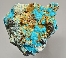
Chrysocolla ( KRIS-ə-KOL-ə) is a hydrous copper phyllosilicate mineral and mineraloid with the formula Cu
2 – xAl
x(H
2Si
2O
5)(OH)
4⋅nH
2O (x < 1) or (Cu, Al)
2H
2Si
2O
5(OH)
4⋅nH
2O).

Kennecott, also known as Kennicott and Kennecott Mines, is an abandoned mining camp in the Copper River Census Area in the U.S. state of Alaska that was the center of activity for several copper mines. It is located beside the Kennicott Glacier, northeast of Valdez, inside Wrangell-St. Elias National Park and Preserve. The camp and mines are now a National Historic Landmark District administered by the National Park Service.

The Copper River and Northwestern Railway (CR&NW) consisted of two rail lines, the Copper River line and the Northwestern line. Michael James Heney had secured the right-of-way up the Copper River in 1904. He started building the railway from Cordova, Alaska in 1906. The town of Cordova, Alaska, was actually named by Heney on March 13, 1906, based on the original name given by Salvador Fidalgo. Both these railroads were abandoned and little remains of them. A 0-4-0 locomotive, "Ole", located near Goose City on a siding of the Alaska Anthracite Railroad Company is the only equipment left. Many of the holdings of the CR&NW railroad including Ole were acquired for this railroad by Mr. Clark Davis and his partners in 1908 after a major storm destroyed the Katalla area facilities in 1907. The town of Cordova would like to move Ole to a memorial site in Cordova to celebrate its role in these railroads. Ole was declared eligible for the National Register of Historic Places in 1988.

The Quincy Mine is an extensive set of copper mines located near Hancock, Michigan. The mine was owned by the Quincy Mining Company and operated between 1846 and 1945, although some activities continued through the 1970s. The Quincy Mine was known as "Old Reliable," as the Quincy Mine Company paid a dividend to investors every year from 1868 through 1920. The Quincy Mining Company Historic District is a United States National Historic Landmark District; other Quincy Mine properties nearby, including the Quincy Mining Company Stamp Mills, the Quincy Dredge Number Two, and the Quincy Smelter are also historically significant.
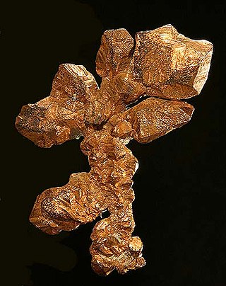
Native copper is an uncombined form of copper that occurs as a natural mineral. Copper is one of the few metallic elements to occur in native form, although it most commonly occurs in oxidized states and mixed with other elements. Native copper was an important ore of copper in historic times and was used by pre-historic peoples.

The Southeast Missouri Lead District, commonly called the Lead Belt, is a lead mining district in the southeastern part of Missouri. Counties in the Lead Belt include Saint Francois, Crawford, Dent, Iron, Madison, Reynolds, and Washington. This mining district is the most important and critical lead producer in the United States.

The Bingham Canyon Mine, more commonly known as Kennecott Copper Mine among locals, is an open-pit mining operation extracting a large porphyry copper deposit southwest of Salt Lake City, Utah, in the Oquirrh Mountains. The mine is the largest man-made excavation, and deepest open-pit mine in the world, which is considered to have produced more copper than any other mine in history – more than 19,000,000 short tons. The mine is owned by Rio Tinto Group, a British-Australian multinational corporation. The copper operations at Bingham Canyon Mine are managed through Kennecott Utah Copper Corporation which operates the mine, a concentrator plant, a smelter, and a refinery. The mine has been in production since 1906, and has resulted in the creation of a pit over 0.75 miles (1,210 m) deep, 2.5 miles (4 km) wide, and covering 1,900 acres. It was designated a National Historic Landmark in 1966 under the name Bingham Canyon Open Pit Copper Mine. The mine experienced a massive landslide in April 2013 and a smaller slide in September 2013.
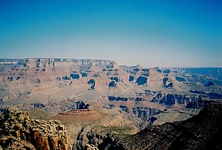
The Grandview Trail is a hiking trail located on the South Rim of the Grand Canyon National Park, located in the U.S. state of Arizona.It was built in 1893 by miners and is noted for its cobblestone and cribbing sections.

Uranium mining in Utah, a state of the United States, has a history going back more than 100 years. Uranium mining started as a byproduct of vanadium mining about 1900, became a byproduct of radium mining about 1910, then back to a byproduct of vanadium when the radium price fell in the 1920s. Utah saw a uranium boom in the late 1940s and early 1950s, but uranium mining declined in the 1980s. Since 2001 there has been a revival of interest in uranium mining, as a result of higher uranium prices.

The Sterling Hill Mine, now known as the Sterling Hill Mining Museum, is a former zinc mine in Ogdensburg, Sussex County, New Jersey, United States. It was the last working underground mine in New Jersey when it closed in 1986, and it became a museum in 1989. Along with the nearby Franklin Mine, it is known for its variety of minerals, especially the fluorescent varieties. It was added to the National Register of Historic Places in 1991.

Pseudomalachite is a phosphate of copper with hydroxyl, named from the Greek for “false” and “malachite”, because of its similarity in appearance to the carbonate mineral malachite, Cu2(CO3)(OH)2. Both are green coloured secondary minerals found in oxidised zones of copper deposits, often associated with each other. Pseudomalachite is polymorphous with reichenbachite and ludjibaite. It was discovered in 1813. Prior to 1950 it was thought that dihydrite, lunnite, ehlite, tagilite and prasin were separate mineral species, but Berry analysed specimens labelled with these names from several museums, and found that they were in fact pseudomalachite. The old names are no longer recognised by the IMA.
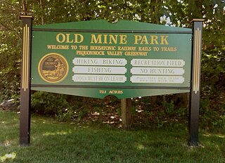
The Old Mine Park Archaeological Site is a historic site in the Long Hill section of Trumbull, Connecticut, United States. It was mined from 1828 to 1920 and during 1942-1946, and has been incorporated in a municipal park. It was added to the National Register of Historic Places in 1990.

The Pahaquarry Copper Mine is an abandoned copper mine located on the west side of Kittatinny Mountain presently in Hardwick Township in Warren County, New Jersey in the United States. Active mining was attempted for brief periods during the mid-eighteenth, mid-nineteenth, and early twentieth centuries but was never successful despite developments in mining technology and improving mineral extraction methods. Such ventures were not profitable as the ore extracted proved to be of too low a concentration of copper. This site incorporates the mining ruins, hiking trails, and nearby waterfalls, and is located within the Delaware Water Gap National Recreation Area and administered by the National Park Service. It was added to the National Register of Historic Places in 1980 as a contributing property to the Old Mine Road Historic District.

The Jackson Mine is an open pit iron mine in Negaunee, Michigan, extracting resources from the Marquette Iron Range. The first iron mine in the Lake Superior region, Jackson Mine was designated as a Michigan State Historic Site in 1956 and listed on the National Register of Historic Places in 1971. The Lake Superior Mining Institute said, the mine "is attractive in the iron ore region of Michigan and the entire Lake Superior region, because of the fact it was here that the first discovery of iron ore was made, here the first mining was done, and from its ore the first iron was manufactured." Multiple other mines soon followed the Jackson's lead, establishing the foundation of the economy of the entire region. The mine is located northwest of intersection of Business M-28 and Cornish Town Road.

The Kamfundwa Mine is one of the Kambove mines in the mining region around Kambove, Katanga Province, Democratic Republic of the Congo. It is near the Shangulowé Mine, about 10 kilometres (6.2 mi) north of the Kamoya mine district.
The Ferris-Haggerty Mine Site was one of the richest components of the Grand Encampment Mining District in Carbon County, Wyoming. The site was first exploited by Ed Haggerty, a prospector from Whitehaven, England, in 1897 when he established the Rudefeha Mine that would later be known as the Ferris-Haggerty Mine on a rich deposit of copper ore. Haggerty was backed by George Ferris and other investors, of whom all but Ferris dropped out. The partners sold an interest to Willis George Emerson, who raised investment funding for improvements to the mine. These facilities included an engineering feat of its day by developing a 16-mile (26 km) aerial tramway to carry high grade copper mined at the Ferris-Haggerty Mine (FHM) over the Continental Divide to the smelter in Encampment. The tramway was longest aerial tramway the world had ever seen. The mine was eventually acquired by the North American Copper Company for 1.23 billion. By 1904 the mine had produced $1.4 million in copper ore, and was sold to the Penn-Wyoming Copper Company. However, even with copper prices peaking in 1907, the company had difficulty making a profit from the remote mine site. The company was over-capitalized and under-insured and was suffered devastating fires at the mine site in March 1906 and May 1907 which halted production. Business disputes and a fall in copper prices prevented re-opening of the mine even after it was rebuilt. Machinery was salvaged after a foreclosure in 1913. A total of 23 million pounds of copper ore was extracted from the mine during its life.

The Mineral Park mine is a large open pit copper mine located in the Cerbat Mountains 14 miles northwest of Kingman, Arizona, in the southwestern United States. A 2013 report said that Mineral Park represented one of the largest copper reserves in the United States and in the world, having estimated reserves of 389 million tonnes of ore grading 0.14% copper and 31 million oz of silver.

Arsendescloizite is a lead-zinc mineral, approved by the IMA in 1982. It is an arsenate analog of descloizite. Its first description was published in 1982.