Ontario College of Art & Design University, commonly known as OCAD University or OCAD, is a public art university located in Toronto, Ontario, Canada. The university's main campus is spread throughout several buildings and facilities within downtown Toronto. The university is a co-educational institution which operates three academic faculties, the Faculty of Art, the Faculty of Arts and Science, and the Faculty of Design. The university also provides continuing education services through its School of Continuing Studies.

High Park is a municipal park in Toronto, Ontario, Canada. High Park is a mixed recreational and natural park, with sporting facilities, cultural facilities, educational facilities, gardens, playgrounds and a zoo. One-third of the park remains in a natural state, with a rare oak savannah ecology. High Park was opened to the public in 1876 and is based on a bequest of land from John George Howard to the City of Toronto. It spans 161 hectares and is the second-largest municipal park in Toronto, after Centennial Park.

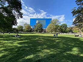
The Art Gallery of Ontario is an art museum in Toronto, Ontario, Canada, located in the Grange Park neighbourhood of downtown Toronto, on Dundas Street West. The building complex takes up 45,000 square metres (480,000 sq ft) of physical space, making it one of the largest art museums in North America and the second-largest art museum in Toronto, after the Royal Ontario Museum. In addition to exhibition spaces, the museum also houses an artist-in-residence office and studio, dining facilities, event spaces, gift shop, library and archives, theatre and lecture hall, research centre, and a workshop.

Trinity Bellwoods Park is a public park located in Toronto, Ontario, Canada, bordered by Queen Street West on the south and Dundas Street on the north. The western boundary of the park is Crawford Street, several hundred feet before Crawford intersects with Dundas St. West, the park juts toward Shaw Street, westside of the Crawford Street Bridge. Most of the park's area lies in the original Garrison Creek ravine and this creek, now a buried city storm sewer, still flows beneath the park from the northwest to the southeast corners.

The Bishop Strachan School is an Anglican day and boarding school for girls in Toronto, Ontario, Canada. The school has approximately 900 students, including 80 boarding students, ranging from Junior Kindergarten to Grade 12. The School is named after John Strachan, the first Anglican bishop of Toronto, and was founded by John Langtry in 1867. The founders' intention was to educate girls to be leaders.
The Queen Street subway line was a proposed subway line for the city of Toronto, Ontario, Canada. It was one of many subway lines planned for, but has yet to be built by the Toronto Transit Commission.

The Grange is a historic Georgian manor in downtown Toronto, Ontario. It was the first home of the Art Museum of Toronto. Today, it is part of the Art Gallery of Ontario.

College Park is a shopping mall, residential and office complex on the southwest corner of Yonge and College streets in Toronto, Ontario, Canada.
George D'Arcy Boulton was a lawyer, judge and political figure in Upper Canada. He was a member of the Family Compact, an oligarchic political and social group which dominated the government of the province.

John Street is a street in Downtown Toronto. It runs from Stephanie Street and Grange Park in the north to the Metro Toronto Convention Centre on Front Street in the south. It is home to a number of Toronto's cultural institutions, including buildings for the CBC, CTV, Toronto International Film Festival. The National Post has described it as "Running directly through the entertainment district, its spine connects many great cultural institutions, popular retail outlets, restaurants and soon-to-be-built condos." The City of Toronto has dubbed the street a "Cultural Corridor" and a report calls it "the centrepiece of the Entertainment District."

The Art Gallery of Hamilton (AGH) is an art museum located in Hamilton, Ontario, Canada. The museum occupies a 7,000 square metres (75,000 sq ft) building on King Street West in downtown Hamilton, designed by Trevor P. Garwood-Jones. The institution is southwestern Ontario's largest and oldest art museum.

Ramsden Park is a public park located at 1020 Yonge Street in Toronto, Ontario, Canada, with access via Ramsden Park Road. and Pears Avenue. With an area of 13.7 acres, Ramsden Park is one of the largest in downtown Toronto. It features playgrounds, basketball courts, hockey rinks and a small skateboarding feature.
St. Andrew's Playground is a small park in downtown Toronto. It is located at the 450 Adelaide Street West, at the northwest corner of Brant St and Adelaide. It has a playground for children and an off-leash area for dogs that is surrounded by a short fence, with an accessible water fountain for pets, children, and adults. A Heritage Toronto plaque in the northwest corner describing the history and significance of the park was installed in 2007.

Little Norway Park is a small park in the Harbourfront area of Toronto, Ontario, Canada, at the southwest corner of Bathurst Street and Queens Quay West. The park is just north of the Western Channel into Toronto Harbour. It was opened in 1986.

Grange Park is a neighbourhood in downtown Toronto, Ontario, Canada. It is bounded on the west by Spadina Avenue, on the north by College Street, on the east by University Avenue and on the south by Queen Street West. It is within the 'Kensington-Chinatown' planning neighbourhood of the City of Toronto. Its name is derived from the Grange Park public park. The commercial businesses of Chinatown extend within this neighbourhood.

Gunns Loop is a station and turning loop at the western terminus of the 512 St. Clair streetcar line of the Toronto Transit Commission (TTC). It is located at the northwest corner of St. Clair Avenue West and Gunns Road, a block west of Keele Street, in Toronto.
Corktown Common is a park in the south eastern portion of the West Don Lands neighbourhood in Toronto, Ontario, Canada which opened in 2013. It borders the Don River to the east. It was built on remediated industrial lands to be the centrepiece of a new emerging neighbourhood in downtown Toronto. It also provides a barrier to flooding from the Don River.

Trillium Park is a park in Toronto owned and operated by the Government of Ontario. Various Ontario landscapes inspired the park design. The William G. Davis Trail passes through the park connecting it to the Martin Goodman Trail.

Dundas Street is a major historic arterial road in Ontario, Canada. The road connects the city of Toronto with its western suburbs and several cities in southwestern Ontario. Three provincial highways—2, 5, and 99—followed long sections of its course, although these highway segments have since been downloaded to the municipalities they passed through. Originally intended as a military route to connect the shipping port of York to the envisioned future capital of London, Ontario, the street today connects Toronto landmarks such as Yonge–Dundas Square and the city's principal Chinatown to rural villages and the regional centres of Hamilton and London.