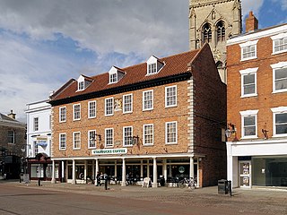
Newark-on-Trent or Newark is a market town and civil parish in the Newark and Sherwood district in Nottinghamshire, England. It is on the River Trent, and was historically a major inland port. The A1 road bypasses the town on the line of the ancient Great North Road. The town's origins are likely to be Roman, as it lies on a major Roman road, the Fosse Way. It grew up round Newark Castle, St Mary Magdalene church and later developed as a centre for the wool and cloth trades.

Blidworth is a village and civil parish approximately five miles east of Mansfield, Nottinghamshire, England. The population of the civil parish at the 2011 census was 4,457. Its history can be traced back to the 10th century, although many of the current houses were built in the first half of the 20th century to provide housing for workers at Blidworth Colliery (1926–1989). These are mainly in estates north of Dale Lane, known as New Blidworth. The area around Main Street, west of Beck Lane and including the church, is Old Blidworth, containing some of the oldest buildings. Blidworth Bottoms is a hamlet about 0.5 km south of Old Blidworth.

Radford is an inner-city area of Nottingham and former civil parish in the Nottingham district, in the ceremonial county of Nottinghamshire, England, located just outside the city centre. The appropriate ward of the City of Nottingham Council is Radford and Park which, in 2011, had a population of 21,414. It is bounded to the south by Lenton and to the east by Nottingham city centre, and comprises around 600 acres (240 ha) of land.
Ruddington is a large village in the Borough of Rushcliffe in Nottinghamshire, England. The village is 5 miles (8 km) south of Nottingham and 11 miles (18 km) northwest of Loughborough. It had a population of 6,441 at the 2001 Census, increasing to 7,216 at the 2011 Census and 7,674 in 2021. Ruddington is twinned with Grenay, France.
East Bridgford is a village and civil parish in the Rushcliffe borough of Nottinghamshire, east of the city of Nottingham. It had a population of 1,814 at the 2011 census. The village adjoins the south bank of the River Trent, opposite the village of Gunthorpe. It is on the Trent Valley Way. East Bridgford's an annual village show is run by the village Horticultural Society, established in 1864, and held every Feast Week.

East Markham, historically also known as Great Markham, is a small village and civil parish near Tuxford, Nottinghamshire. The population of the civil parish taken at the 2011 Census was 1,160, and this increased to 1,279 in 2021. It lies about 8 km south of Retford. It is sandwiched between the East Coast Main Line, the A1 to the west and A57 to the north.

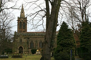
Plumtree is a village and civil parish in the borough of Rushcliffe, Nottinghamshire. At the time of the 2001 census it had a population of 221, increasing to 246 at the 2011 census. It is situated 5 miles south east of Nottingham, between the villages of Tollerton and Keyworth. Some of the farming land around the village is owned by the Duchy of Cornwall. The parish church of St Mary has a Norman tower on Saxon foundations, which were found when the tower was rebuilt in 1906. The nave is of 13th-century date. The north aisle was rebuilt and extended with stone from Nottingham's medieval Trent Bridge in 1873. Edward Hagarty Parry (1855–1931), an association footballer who captained Old Carthusians F.C. when they won the 1881 FA Cup Final against Old Etonians, is buried in the churchyard.

Elston is a village and civil parish in Nottinghamshire, England, to the south-west of Newark, and a mile from the A46 Fosse Way. The population of the civil parish taken at the 2011 Census was 631. It lies between the rivers Trent and Devon, with the village "set amongst trees and farmland less than a mile from the A46.... Newark is five miles to the north, with... Lincoln and Nottingham some 18 miles north and south-west respectively."

Carlton-on-Trent is a small village and civil parish in England, located between the River Trent and the A1 road near Newark-on-Trent in Nottinghamshire. The population of the civil parish was 228 at the 2001 census increasing marginally only to 229 at the 2011 census.

Caunton is a village and civil parish in the Newark and Sherwood district of Nottinghamshire on the A616, six miles (9.7 km) north-west of Newark-on-Trent, in the NG23 postcode. The population of the civil parish at the 2011 Census was 483.

Farnsfield is a large village and civil parish in Nottinghamshire in Sherwood Forest. It is in the local government district of Newark and Sherwood. The population of the civil parish as at the 2011 Census was 2,731, an increase from 2,681 in the United Kingdom Census 2001.
Whatton-in-the-Vale is an English village in the Nottinghamshire borough of Rushcliffe. It lies in the Vale of Belvoir, with the River Smite to the west and the River Whipling to the east, mainly north of the trunk A52 road, 12 miles (19 km) east of Nottingham. It had a population of 843 at the 2011 census.

Misterton is a village and civil parish in the Bassetlaw district of Nottinghamshire, England. The parish population at the 2011 census was 2,140, estimated at 2,145 in 2019.

Coddington is an English village and civil parish in Nottinghamshire, 3 miles (4.8 km) east of Newark-on-Trent. According to the 2001 census it had a population of 972, which increased to 1,684 at the 2011 Census and to 1,701 at the 2021 Census.

Warsop is a town and civil parish in Mansfield District, Nottinghamshire, England, on the outskirts of the remnants of Sherwood Forest. At the 2021 census the population was 12,644 resaidents, including Church Warsop, Meden Vale, Sookholme and Spion Kop.

Staunton is a small village and civil parish in the Newark and Sherwood district of Nottinghamshire, England. It takes its name from the Vale of Belvoir and shares it with the local Staunton family, which has resided in the area since the Norman Conquest and possibly before, making them one of the English families living longest on its own estate.

Kersall is a hamlet and civil parish within the Newark and Sherwood district of central Nottinghamshire, England.
North and South Wheatley is a civil parish in the Bassetlaw district, in the county of Nottinghamshire, England. The parish includes the villages of North Wheatley and South Wheatley. In 2021 the parish had a population of 610 residents. It is 130 miles north of London, 30 miles north east of the county town of Nottingham, and 5 miles north east of the Nottinghamshire town of Retford. The parish touches Bole, Clarborough and Welham, Clayworth, Hayton, Saundby, Sturton Le Steeple and West Burton. There are 18 listed buildings in North and South Wheatley.

Little Gringley is a hamlet in the Bassetlaw district of northern Nottinghamshire, England. It is 130 miles (210 km) north of London, 27 miles (43 km) north east of the county town and city of Nottingham, and 1+3⁄4 miles (2.8 km) east of the nearest town Retford.


