The Guadiana River, or Odiana, is an international river defining a long stretch of the Portugal-Spain border, separating Extremadura and Andalucia (Spain) from Alentejo and Algarve (Portugal). The river's basin extends from the eastern portion of Extremadura to the southern provinces of the Algarve; the river and its tributaries flow from east to west, then south through Portugal to the border towns of Vila Real de Santo António (Portugal) and Ayamonte (Spain), where it flows into the Gulf of Cádiz. With a course that covers a distance of 829 kilometres (515 mi), it is the fourth-longest in the Iberian peninsula, and its hydrological basin extends over an area of approximately 68,000 square kilometres (26,000 sq mi).
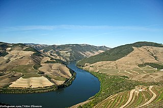
The Douro is the highest-flow river of the Iberian Peninsula. It rises near Duruelo de la Sierra in Soria Province, central Spain, meanders south briefly then flows generally west through the north-west part of central Spain and into northern Portugal, to its mouth at Porto, the second city of Portugal. At its mouth it meets the Atlantic Ocean.

Ourense is a Spanish province, in the southeastern part of the autonomous community of Galicia. It is bordered by the provinces of Pontevedra to the west, Lugo to the north, León and Zamora, to the east, and by Portugal to the south. With an area of 7,278 square km it is the only landlocked province in Galicia. The provincial capital, Ourense, is the largest population centre, with the rest of the province being predominantly rural.

Olivenza or Olivença is a town situated on an historically disputed section of the Portugal–Spain border. Its territory is administered by Spain as a municipality belonging to the province of Badajoz, and to the wider autonomous community of Extremadura.
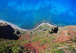
Cabo Girão is a lofty sea cliff located along the southern coast of the island of Madeira, in the Portuguese archipelago of Madeira. Cabo Girão is a popular lookout point, with up to 1800 visitors a day. The location is also a popular starting point for hikers.
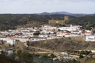
Mértola is a municipality in southeastern Portuguese Alentejo near the Spanish border. In 2011, the population was 7,274, in an area of approximately 1,292.87 square kilometres (499.18 sq mi): it is the sixth-largest municipality in Portugal. Meanwhile, it is the second-lowest population centre by density with approximately 5.62 persons/1 square kilometre (0.39 sq mi).

Alandroal is a municipality in the Portuguese district of Évora located on the eastern frontier with Spain along the right margin of the Guadiana River in the Central Alentejo region. It is located 341 metres (1,119 ft) above sea level, northeast of Évora and southeast of Estremoz. The population in 2011 was 5,843, in an area of 542.68 km².

Norte or Northern Portugal is the most populous region in Portugal, ahead of Lisboa, and the third most extensive by area. The region has 3,576,205 inhabitants according to the 2017 census, and its area is 21,278 kilometres (13,222 mi) with a density of 173 inhabitants per square kilometre. It is one of five regions of Mainland Portugal. Its main population center is the urban area of Porto, with about one million inhabitants; it includes a larger political metropolitan region with 1.8 million, and an urban-metropolitan agglomeration with 2.99 million inhabitants, including Porto and a number of urban areas in Northwestern Portugal, like Braga and Guimarães. The Commission of Regional Coordination of the North (CCDR-N) is the agency that coordinates environmental policies, land-use planning, cities and the overall development of this region, supporting local governments and associations.

Torres is a city on the coast of south Brazil in the state of Rio Grande do Sul. The city has a population of approximately 40,000 inhabitants, of which 10,000 live in rural zones, but in summer the number of inhabitants reaches 300,000.

Serra da Canastra National Park is a national park in the Canastra Mountains of the state of Minas Gerais, Brazil.
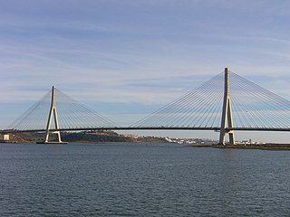
The Guadiana International Bridge is a bridge that crosses the Guadiana River connecting southern Spain and Portugal. It is the southernmost land crossing on the Portugal–Spain border. It is not split evenly between the two countries, a greater share of it situated in Portugal. Completed in 1991, its structural type is a cable-stayed bridge, with a deck of prestressed concrete. The bridge was designed by the Portuguese Structural Engineer Professor José Luis Câncio Martins on behalf of Huarte S.A. and Teixeira Duarte. The bridge is open to vehicles only. It is the third longest bridge in Portugal and one of the longest in Spain.
The Protected areas of Portugal are classified under a legal protection statute that allows for the adequate protection and maintenance of biodiversity, while providing services for ecosystem that maintains the natural and geological patrimony.

Lagunas de Ruidera Natural Park is a natural park in Spain, containing 15 small lagoons, the Lagunas de Ruidera, that are located in the La Mancha plain. The park's area is covers roughly 38 square kilometres (15 sq mi), reaching into the municipalities of Argamasilla de Alba, Ruidera, Alhambra, Ossa de Montiel and Villahermosa.

The Castle of Redondo is a medieval castle located in the civil parish of Redondo, in the municipality of Redondo, Portuguese Évora.

Serra de São Mamede is a mountain range in Portalegre District, Portugal. This range is named after Saint Mammes. Together with the Serra de Arraiolos, the Serra de São Mamede is one of the few places in the Alentejo region where there might be snow in the winter.
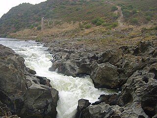
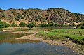
Pulo do Lobo is a waterfall 17 km north of Mértola, in the Lower Alentejo region of Portugal. It is the highest waterfall in Southern Portugal. Its name means "wolf's leap" in English; it was said that only a brave man or a wild animal when chased could leap over the gorge that was created by the waterfall. This waterfall is located at an altitude of between 33 and 35 metres in a very narrow gorge in the River Guadiana.

The Alentejo is a geographical, historical and cultural region of south central and southern Portugal. In Portuguese, its name means "beyond the Tagus river" (Tejo).
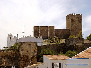
The Castle of Mértola is a well-preserved medieval castle located in the civil parish and municipality of Mértola, in the Portuguese district of Beja.

The Castle of Noudar, is a Portuguese medieval castle in the civil parish and municipality of Barrancos, in the district of Beja.

 Pulo do Lobo (Wolf's Leap) is a waterfall in the Guadiana river, in the Guadiana Valley Natural Park.
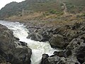 Pulo Do Lobo, flow gage tower