The Tagus is the longest river in the Iberian Peninsula. The river rises in the Montes Universales in mid-eastern Spain, flows 1,007 km (626 mi), generally west with two main south-westward sections, to empty into the Atlantic Ocean near Lisbon. Its drainage basin covers 80,100 square kilometers (30,927 sq mi) – exceeded in the peninsula only by the Douro. The river is highly used. Several dams and diversions supply drinking water to key population centres of central Spain and Portugal; dozens of hydroelectric stations create power. Between dams it follows a very constricted course, but after Almourol, Portugal it has a wide alluvial valley, prone to flooding. Its mouth is a large estuary culminating at the major port, and Portuguese capital, Lisbon.

The Douro is the highest-flow river of the Iberian Peninsula. It rises near Duruelo de la Sierra in Soria Province, central Spain, meanders south briefly then flows generally west through the north-west part of central Spain and into northern Portugal, to its mouth at Porto, the second largest city of Portugal. At its mouth it meets the Atlantic Ocean.

The Ria Formosa lagoon, located in the Algarve, in southern Portugal, is a system of barrier islands that communicates with the sea through six inlets. Five of these inlets are natural and have mobility characteristics. The sixth is an artificial inlet that was opened with the purpose of allowing easier access to the port of Faro. In 2010, the lagoon was recognised as one of the country’s seven natural wonders. Following a public vote in which 656,356 voted, the Ria Formosa was announced the winner of the Marine Area category of the ‘7 Maravilhas Naturais de Portugal’.

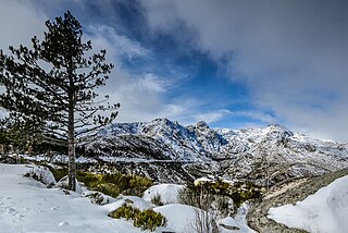
Serra da Estrela Natural Park is situated in the largest mountain range in Portugal - the Serra da Estrela, and is the source of the rivers Mondego, Zêzere, and Alva. The park is the largest natural conservation area in Portugal and occupies about 1,000 km². More than half of its area is located above an altitude of 700 m. At 1,993 m it contains the highest peak in Continental Portugal and a ski resort.

Alvão Natural Park is a protected area founded in 1983, and located in the municipalities of Mondim de Basto and Vila Real, in the Tâmega and Douro Subregions of northern Portugal. Although the smallest of Portugal's natural parks, it extends through 72.2 square kilometres (27.9 sq mi) of mountainous land, populated by approximately 700 locals.

Paul de Arzila is a Portuguese natural reserve occupying an area in Coimbra municipality, and neighbouring municipalities of Condeixa-a-Nova and Montemor-o-Velho. It is a biogenetical reserve with an area of 150 ha framed in a protected area of 535 ha, where 119 species of birds, 12 of mammals, 10 of reptiles, 13 of fish and 201 of spiders were inventoried.

The Sintra-Cascais Natural Park is a park on the Portuguese Riviera, one of the 13 Natural Parks of Portugal. While only established in 1994 as a Natural Park by the Portuguese Government, it has been protected since 1981. Its area is approximately 145 km2. The park includes the Serra de Sintra Mountain Range but extends all the way to the coast and Cabo da Roca, continental Europe's westernmost point. It contains the Castle of the Moors. Located within 25 km of Lisbon, the Sintra-Cascais Natural Park is a popular tourism area, with many different individual historical and natural sites and attractions. Sintra and Cascais are towns and municipalities in the Lisbon / Estoril Coast.

The Douro International Natural Park is a natural park in northeast Portugal. With 868 km2 (335 sq mi), it is one the largest protected areas in the country. It is located in the municipalities of Miranda do Douro, Mogadouro, Freixo de Espada à Cinta and Figueira de Castelo Rodrigo, spanning a lengthy area along the Douro River where it functions as the border between Portugal and Spain. The park also goes includes the border area of the Águeda River. The park was created to protect the scenic landscape of the region, as well as its flora and fauna.
Sankan Biriwa is a mountain massif in the east of Sierra Leone with two peaks, both over 1,800 metres, the northernmost is the second highest in Sierra Leone at 1,850 m. The mountain is part of the Tingi Hills Forest Reserve.

Serra de São Mamede Natural Park is a natural park in the Serra de São Mamede range, Portugal. It is one of the 30 areas which are officially under protection in the country.

Southwest Alentejo and Vicentine Coast Natural Park (PNSACV) is a natural park located in southwest Portugal. It occupies an area of 895.7 km2 (345.8 sq mi) and is one of the last strongholds of the wild European coast. It has one of the highest levels of biodiversity in the country with over 12 endemic species of plant and several bird nesting sites.

Berlengas Natural Reserve is a Portuguese natural reserve in the Berlengas, a small archipelago off the coast of Peniche, Portugal. Over 98% of its 95.6 km2 (36.9 sq mi) are marine. The symbol of the protected area is the common murre, which has, or had, its southernmost nidifying population in the islands.

Sado Estuary Natural Reserve is a nature reserve in Portugal. It is one of the 30 areas which are officially under protection in the country. It is located between the municipalities of Alcácer do Sal, Comporta and Setúbal.

Serra de Montejunto Protected Landscape is a protected landscape in the Montejunto-Estrela mountain range, spanning the municipalities of Alenquer and Cadaval in Lisbon District, Portugal. It is the highest natural viewpoint of Estremadura, rising to 666 metres (2,185 ft) of altitude. The area is part of the Estremenho Limestone Massif. Geologically is 15 kilometres (9.3 mi) long and 7 kilometres (4.3 mi) wide, and is rich in caves, sewage ponds and prehistoric fossils.

Ponta dos Rosais is a promontory located along the northwestern coast of the parish of Rosais, municipality of Velas, on the island of São Jorge in the Portuguese archipelago of the Azores.

The East African montane moorlands is a montane grasslands and shrublands ecoregion which occupies several high mountain peaks in Kenya, South Sudan, Tanzania, and Uganda.

Sierra de San Pedro is a mountain range in the greater Montes de Toledo range, Spain. It is named after Saint Peter the apostle and rises in the limits of Cáceres and Badajoz Provinces, in the western part of the autonomous community of Extremadura close to its border with Portugal. This range gives its name to the Sierra de San Pedro - Los Baldíos comarca.

Alto Tajo Nature Reserve is a Natural Reserve in Guadalajara Province of Spain. The park is famous for its canyons and gorges formed by the Tagus river and its tributaries which flow through the park, besides its pine forests and imposing cliffs. The park provides the setting for José Luis Sampedro's novel El río que nos lleva (1961). The park was also the one of the filming locations of Game of Thrones.

The Rajang Mangroves National Park is a national park in Sarikei Division, Sarawak, Malaysia. It is home to species such as proboscis monkeys, silvered langurs, lesser adjutant storks and hornbills. .

Savage Islands Nature Reserve is a Portuguese nature reserve located in the Savage Islands, a small archipelago in the Northeast Atlantic Ocean. Created in 1971, it is one of the oldest protected areas in the country. The strict nature reserve occupies an area of 94.32 km2 (36.42 sq mi) and over 95% of the total area is maritime.


