Hahndorf, South Australia

Last updated

Hahndorf
South Australia
HahndorfSA.JPG
Hahndorf main street
Australia South Australia location map.svg
Red pog.svg
Hahndorf
Coordinates 35°01′49″S138°48′28″E / 35.030267°S 138.807646°E / -35.030267; 138.807646 [1]
Population2,313 (UCL 2021) [2]
Established1839
Postcode(s) 5245
Location
  • 28 km (17 mi) from Adelaide's CBD
  • 7 km (4 mi) from Mount Barker
LGA(s)
State electorate(s) Heysen
Federal division(s) Mayo
Localities around Hahndorf:
Bridgewater Verdun Balhannah
Mylor Hahndorf Totness
Biggs Flat Echunga Paechtown
Footnotes [3]

Hahndorf is a small town in the Adelaide Hills region of South Australia. Currently an important tourism spot, it has previously been a centre for farming and services.

Contents

History

The town was settled by Lutheran migrants largely from in and around a small village then named Kay in Prussia and now known as Kije, Lubusz Voivodeship in Poland. Many of the settlers arrived aboard the Zebra on 28 December 1838. The town is named after Dirk Meinerts Hahn, the German captain of the Zebra. It is Australia's oldest surviving German settlement.

Early German settlers

During the British colonisation of South Australia, the settlers were mostly British, but some German "Old Lutherans" also emigrated in the early years. The first large group of Germans arrived in 1838, with the financial assistance of the Emigration Fund. Most moved out of Adelaide and to the Barossa Valley and settlements in the Hills such as Hahndorf, living in socially closed communities, by 1842, and did not participate in government until 15 years later. [4]

German influence

German influence is apparent in Hahndorf and is seen in the traditional fachwerk architecture of the original surviving buildings. There are also many restaurants in the town serving German cuisine.

Due to the First World War in Europe, in 1917 the South Australian Government changed many German place names. The name Hahndorf was changed to Ambleside after the nearby Ambleside railway station. [5] Hahndorf was re-instated as the town's name with the enactment of the South Australia Nomenclature Act of 1935 on 12 December 1935. [6] There are still references to the name Ambleside in and around the town today.

Demographics

Hahndorf
population by year
20061,806
20162,670 [7]

At the census 2006 the population was 1,806. In 2016 the population was 2,670.

Government

Located in the federal division of Mayo, the state electoral district of Heysen, [8] and the local government areas of the District Council of Mount Barker [1] and the Adelaide Hills Council. [1]

Churches

St. Paul's Lutheran Church Hahndorf (AU), St Paul's Lutheran Church -- 2019 -- 0679.jpg
St. Paul's Lutheran Church

There are two prominent churches in Hahndorf. St Michael's is the oldest Lutheran church in Australia to still have a worshipping congregation on its original church site. It was founded in 1839. St Michael's is a member of the Lutheran Church of Australia. St Paul's was founded in 1846, as a result of a schism between the Pastor Kavel, and Pastor Fritzsche. This schism is closely linked to the formation of two original Lutheran synods in Australia which coexisted until their merger in 1966.

C3 Adelaide Hills

C3 Adelaide Hills is a church part of the C3 Church Global movement. Previously located in Nairne it moved to Hahndorf around 2007 [ citation needed ].

Geography

It is accessible from Adelaide, the South Australian capital, via the South Eastern Freeway.

Climate

Hahndorf has a warm-summer Mediterranean climate abbreviated Csb on the Köppen climate classification scale.

Climate data for Hahndorf
MonthJanFebMarAprMayJunJulAugSepOctNovDecYear
Mean daily maximum °C (°F)28.0
(82.4)
28.0
(82.4)
25.0
(77.0)
21.0
(69.8)
17.0
(62.6)
14.0
(57.2)
13.0
(55.4)
15.0
(59.0)
17.0
(62.6)
20.0
(68.0)
23.0
(73.4)
25.0
(77.0)
20.5
(68.9)
Daily mean °C (°F)20.5
(68.9)
20.0
(68.0)
18.0
(64.4)
15.0
(59.0)
12.0
(53.6)
9.5
(49.1)
9.0
(48.2)
10.0
(50.0)
11.5
(52.7)
14.0
(57.2)
17.0
(62.6)
18.0
(64.4)
14.5
(58.2)
Mean daily minimum °C (°F)13.0
(55.4)
12.0
(53.6)
11.0
(51.8)
9.0
(48.2)
7.0
(44.6)
5.0
(41.0)
5.0
(41.0)
5.0
(41.0)
6.0
(42.8)
8.0
(46.4)
9.0
(48.2)
11.0
(51.8)
8.4
(47.2)
Average rainfall mm (inches)24.2
(0.95)
21.8
(0.86)
30.4
(1.20)
54.2
(2.13)
73.0
(2.87)
89.5
(3.52)
108.5
(4.27)
101.6
(4.00)
82.5
(3.25)
55.8
(2.20)
33.6
(1.32)
38.6
(1.52)
713.7
(28.09)
Average rainy days324691112131075587
Source: NOAA. [9]

Sports

Hahndorf's sporting clubs including basketball, bowls, netball, cricket, football (Australian rules and Association Football), tennis and softball. The football (both codes), netball and softball clubs are nicknamed The Magpies.

The Hahndorf Bowling Club was established in 1976 and has a full size (nine rink) green, which is a woven carpet surface enabling all weather competition, and a large clubhouse.

The (soccer) Football Club was formed in the early 1980s and plays home games at "Pine Avenue". The senior men compete in the South Australian Amateur Soccer League. They won the 1996 Newsfront Cup and the 2004 Amateur League Division Two title. However, a gradual decline in player numbers from 2013 have seen the side drop to one team, competing in Division Seven, by 2019.

Hahndorf was the start point of the 2024 Women's Tour Down Under.[ citation needed ]

Notable residents

See also

Related Research Articles

<span class="mw-page-title-main">Birdwood, South Australia</span> Town in South Australia

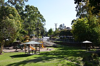
Birdwood is a town near Adelaide, South Australia. It is located in the local government areas of the Adelaide Hills Council and the Mid Murray Council.

<span class="mw-page-title-main">Adelaide Hills</span> Region in South Australia

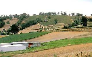
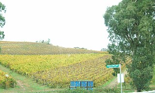
The Adelaide Hills region is located in the southern Mount Lofty Ranges east of the city of Adelaide in the state of South Australia. The largest town in the area, Mount Barker is one of Australia's fastest-growing towns. Before British colonisation of South Australia, the area was inhabited by the Peramangk people.

<span class="mw-page-title-main">Hans Heysen</span> Australian artist

Sir Hans Heysen was an Australian artist. He became a household name for his watercolours of monumental Australian gum trees. One of Australia's best known landscape painters, he is remembered for his depictions of sheep and cattle among massive gum trees against a background of atmospheric effects of light, of men and animals toiling in the Australian bush, and arid landscapes in the Flinders Ranges. He won the Wynne Prize for landscape painting a record nine times.

<span class="mw-page-title-main">Pinnaroo, South Australia</span> Town in South Australia

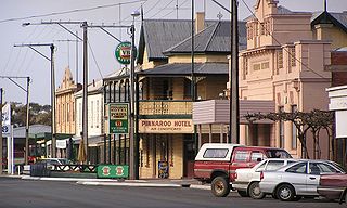
Pinnaroo is a town in the Murray Mallee region of South Australia, near the border with Victoria, 243 km east of Adelaide. Pinnaroo is on the north side of the Mallee Highway, and on the railway line between Tailem Bend and Ouyen. The roadhouse on the highway at Pinnaroo is the first "food and leg-stretch" stop on the bus route from Adelaide to Sydney.

<span class="mw-page-title-main">August Kavel</span>

August Ludwig Christian Kavel was a founder of Lutheranism in Australia.

The Zebra was a three-masted ship, built in 1818. On 12 August 1838, Zebra, Dirk Meinerts Hahn, master, departed from Altona, Hamburg on a voyage to Port Misery, South Australia. The ship arrived at its destination on 28 December 1838. On board was a crew of 16 and 188 passengers with their belongings. In addition, the ship carried 100 barrels of pork, 100 barrels of flour, 65 barrels of fresh water, 17 hogsheads of beer and vinegar, 14 barrels of herrings, two boxes of boots and 40,924 bricks.

<span class="mw-page-title-main">Lobethal</span> Town in South Australia

Lobethal is a town in the Adelaide Hills area of South Australia. It is located in the Adelaide Hills Council local government area, and is nestled on the banks of a creek between the hills and up the sides of the valley. It was once the centre of the Adelaide Hills wool processing industry, which continued until around 1950. The mill buildings are now used by a number of cottage industry and handcraft businesses. At the 2016 census, Lobethal had a population of 2,135.

<span class="mw-page-title-main">Aldgate, South Australia</span> Suburb of Adelaide, South Australia

Aldgate is a South Australian village and a suburb of Adelaide, located 21 km (13 mi) south-east of the Adelaide city centre, in the Adelaide Hills.

<span class="mw-page-title-main">Jabuk, South Australia</span> Town in South Australia

Jabuk is a locality in the Australian state of South Australia located about 142 kilometres (88 mi) south-east of the state capital of Adelaide and respectively about 78 kilometres (48 mi) west and 58 kilometres (36 mi) east of the municipal seats of Pinnaroo and Tailem Bend.

<span class="mw-page-title-main">Coonalpyn, South Australia</span> Town in South Australia

Coonalpyn is a town and a locality in the Australian state of South Australia located about 143 kilometres (89 mi) south-east of the state capital of Adelaide and about 61 kilometres (38 mi) south-east of the municipal seat in Tailem Bend. It is situated in the local government area of the Coorong District Council and is in the State electoratal district of MacKillop and the Federal division of Barker.

<span class="mw-page-title-main">Bridgewater, South Australia</span> Town in South Australia

Bridgewater is a town in South Australia, located in the Adelaide Hills to the south-east of the Adelaide city centre.

<span class="mw-page-title-main">Chain of Ponds, South Australia</span> Suburb of Adelaide Hills Council, South Australia

Chain of Ponds is a locality and former town near Adelaide, South Australia. It is located in the Adelaide Hills Council local government area.

Ironbank is a semi-rural suburb of Adelaide, South Australia. It is in the City of Onkaparinga and Adelaide Hills Council local government areas, approximately 21.9 km from the Adelaide city centre.

<span class="mw-page-title-main">Robertstown, South Australia</span> Town in South Australia

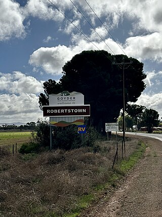
Robertstown is a town in the Mid North region of South Australia, situated 125 km north of Adelaide, in the Regional Council of Goyder. At the 2021 census, Robertstown had a population of 223 people.

Nangwarry is a town and a locality in the Australian state of South Australia located about 352 kilometres (219 mi) south-east of the state capital of Adelaide and about 32 kilometres (20 mi) north-west of the regional centre of Mount Gambier.

<span class="mw-page-title-main">Ramco, South Australia</span> Town in South Australia

Ramco is a town in the Riverland region of South Australia 170 kilometres (110 mi) north-east of the state capital, Adelaide and 7 kilometres (4.3 mi) west of Waikerie. At the 2016 census, Ramco had a population of 166. It is on the south (left) bank of the Murray River downstream from Waikerie.

<span class="mw-page-title-main">T. W. Boehm</span> German-Australian teacher

Traugott Wilhelm Boehm was a schoolmaster, founder of the German School in Hahndorf, South Australia, which became Hahndorf Academy then Hahndorf College.

<span class="mw-page-title-main">South Kilkerran, South Australia</span> Town in South Australia

South Kilkerran is a locality in the Australian state of South Australia located on Yorke Peninsula between Maitland and Port Victoria.

<span class="mw-page-title-main">Mount George, South Australia</span> Town in South Australia

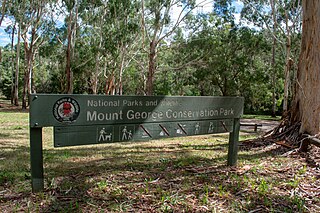
Mount George is a locality in the Australian state of South Australia located about 17 kilometres (11 mi) south-east of the state capital of Adelaide.

Mount Crawford is a locality in the Mount Lofty Ranges of South Australia. It is named after the mountain of the same name in its boundaries, also known as Teetaka.

References

  1. 1 2 3 4 5 "Search results for 'Hahndorf, LOCB' with the following datasets selected - 'Suburbs and localities', 'Counties', 'Local Government Areas', 'SA Government Regions' and 'Gazetteer'". Location SA Map Viewer. South Australian Government. Retrieved 28 December 2018.
  2. Australian Bureau of Statistics (28 June 2022). "Hahndorf (urban centre and locality)". Australian Census 2021.  OOjs UI icon edit-ltr-progressive.svg
  3. "Placename Details: Hahndorf (LOCB)". Property Location Browser Report. Government of South Australia. 1 August 2007. SA0028887. Archived from the original on 12 October 2016. Retrieved 8 February 2018.
  4. Harmstorf, Ian (5 June 2015). "Germans". Adelaidia. "First published in The Wakefield companion to South Australian history, edited by Wilfrid Prest, Kerrie Round and Carol Fort (Adelaide: Wakefield Press, 2001). Edited lightly and references updated". Retrieved 6 December 2019.
  5. Wajnryb, Ruth (2006). Australian Place Name Stories. Lothian Books. p. 5. ISBN   0-7344-0623-1.
  6. Nomenclature Act, 1935
  7. Australian Bureau of Statistics (27 June 2017). "Hahndorf (Urban Centre/Locality)". 2016 Census QuickStats. Retrieved 1 August 2020. OOjs UI icon edit-ltr-progressive.svg
  8. "Heysen". 2022-2026 electoral district map. Electoral Commission of South Australia . Retrieved 18 August 2022.
  9. "National Centers for Environmental Information" . Retrieved 7 September 2020.
  10. "Heysen - The Cedars" . Retrieved 13 June 2016.