Cudlee Creek is a small town near Adelaide, South Australia. It is located in the Adelaide Hills Council local government area.
Glengowrie is a suburb of the Australian city of Adelaide, approximately 12 kilometres south west of the city centre. The name Glengowrie means "Glen of Gowrie", so called in honour of Lord Gowrie, Governor-General of Australia from 1936 to 1944.

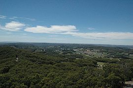
Stirling is a town in the Adelaide Hills, South Australia, approximately 15 km from the Adelaide city centre. It is administered by the Adelaide Hills Council. Neighbouring townships are Crafers and Aldgate. Other nearby towns are Heathfield and Bridgewater. Of those five, Stirling has by far the largest commercial strip, with the greatest number and widest variety of shops, and the only banks. Stirling East, a similar sized area towards Aldgate, is home to several schools.

Athelstone is a suburb of Adelaide in the City of Campbelltown. It was established in the 19th century but only became part of suburban Adelaide in the second half of the 20th century.

Parkside is an inner southern suburb of Adelaide, South Australia. It is located in the City of Unley.
Royston Park is a suburb of Adelaide in the City of Norwood Payneham St Peters. It is a narrow suburb at a little more than 200 m wide. It was created by a subdivision in 1909. Royston Park is bordered by Joslin and Marden, along with the River Torrens.
Warradale is a suburb of Adelaide in the City of Marion. The name Warradale derives from Warripari, an Aboriginal (Kaurna) word for windy place by the (Sturt) River. The suburb is located in the south western part of Adelaide, approximately 12 kilometres from the CBD, and is serviced by the Seaford-Tonsley train line and several main roads.

Broadview is a suburb of Adelaide, South Australia. It is located in the City of Port Adelaide Enfield and the City of Prospect.
Peterhead is a north-western suburb of Adelaide 15 km from the CBD, on the LeFevre Peninsula, in the state of South Australia, Australia and falls under the City of Port Adelaide Enfield. It is adjacent to Largs Bay and Birkenhead. The postcode for Peterhead is 5016. It is bounded to the north by Wills Street, to the south by Hargrave Street and in the west and east by the Outer Harbor railway line and the Port River respectively.

Croydon Park is a north-western suburb of Adelaide 5.9 km from the CBD, in the state of South Australia, Australia and is within the City of Port Adelaide Enfield. It is adjacent to Dudley Park, Devon Park, Renown Park, Regency Park, Ferryden Park Kilkenny, and West Croydon. The post code for Croydon Park is 5008. It is bounded to the south by Lamont Street and Torrens Road, to the north by Regency Road and in the east and west by Harrison Road and Goodall Avenue respectively. Croydon Park is predominantly a residential suburb, with a warehousing presence on the northern edges near Regency Road. Croydon Park has been completely divided by the North-South Motorway.

Vista is a small north-eastern suburb of Adelaide, South Australia and is within the City of Tea Tree Gully local government area. It is adjacent to Houghton, Tea Tree Gully, St Agnes and Hope Valley.

Bowden is an inner northern suburb of Adelaide, South Australia. It is located in the City of Charles Sturt.

Valley View is a suburb of Adelaide, South Australia. It spans three separate local government areas. They are the City of Salisbury, the City of Port Adelaide Enfield, and the City of Tea Tree Gully. The suburb's boundaries are defined by the intersection of Walkleys, Grand Junction and North East Roads in the south, and Wright and Kelly Roads in the north and east.

Renown Park is an inner northern suburb of Adelaide, South Australia. It is located in the City of Charles Sturt.
Fulham Gardens is a western suburb of Adelaide, South Australia in the City of Charles Sturt.
Fairview Park is a north-eastern suburb of Adelaide, South Australia within the City of Tea Tree Gully. It is at the base of the Adelaide Hills.

Ridgehaven is a suburb of Adelaide, South Australia in the City of Tea Tree Gully.

Richmond is an inner suburb of Adelaide, South Australia. It is located on Kaurna land in the City of West Torrens.

Welland is an inner suburb of Adelaide in the City of Charles Sturt local government area. It is around 5 km west northwest of the city centre. It was named for Welland, Worcestershire in 1907.
This page is based on this
Wikipedia article Text is available under the
CC BY-SA 4.0 license; additional terms may apply.
Images, videos and audio are available under their respective licenses.