
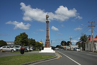
Oamaru is the largest town in North Otago, in the South Island of New Zealand, it is the main town in the Waitaki District. It is 80 kilometres (50 mi) south of Timaru and 120 kilometres (75 mi) north of Dunedin on the Pacific coast; State Highway 1 and the railway Main South Line connect it to both cities. With a population of 14,000, Oamaru is the 28th largest urban area in New Zealand, and the third largest in Otago behind Dunedin and Queenstown. The town is the seat of Waitaki District, which includes the surrounding towns of Kurow, Weston, Palmerston, and Hampden, which combined have a total population of 23,200.

The Waitaki River is a large braided river in the South Island of New Zealand. It drains the Mackenzie Basin and runs 209 kilometres (130 mi) south-east to enter the Pacific Ocean between Timaru and Oamaru on the east coast. It starts at the confluence of the Ōhau and Tekapo rivers, now at the head of the artificial Lake Benmore, these rivers being fed by three large glacial lakes, Pukaki, Tekapo, and Ōhau at the base of the Southern Alps. The Waitaki flows through Lake Benmore, Lake Aviemore and Lake Waitaki, these lakes being contained by hydroelectric dams, Benmore Dam, Aviemore Dam and Waitaki Dam. The Waitaki has several tributaries, notably the Ahuriri River and the Hakataramea River. It passes Kurow and Glenavy before entering the Pacific Ocean. The River lends its name the Waitaki District on the south side of the river bank.

Kurow is a small town in the Waitaki District, New Zealand. It is located on the south bank of the Waitaki River, 60 kilometres (37 mi) northwest of Oamaru.

Waitaki District is a territorial authority district that is located in the Canterbury and Otago regions of the South Island of New Zealand. It straddles the traditional border between the two regions, the Waitaki River, and its seat is Oamaru.

The Awatere River is a large river flowing through Marlborough, New Zealand. Flowing along the trace of the active Awatere Fault, it runs northeast through a straight valley to the west of the Inland Kaikōura mountains. This valley is parallel with that of the Waiau Toa / Clarence River, 20 kilometres (12 mi) to the south.

Rakaia is a town sited on the southern banks of the Rakaia River on the Canterbury Plains in New Zealand's South Island, approximately 57 km south of Christchurch on State Highway 1 and the Main South Line. Immediately north of the township are New Zealand's longest road bridge and longest rail bridge, both of which cross the wide shingle beds of the braided river at this point. Both bridges are approximately 1,750 metres (5,740 ft) in length.

Te Papapa is a suburb of Auckland, New Zealand. It is located nine kilometres to the southeast of Auckland city centre, on the northern shore of Māngere Inlet, an arm of the Manukau Harbour. The residential and light-industrial suburb lies between the suburbs of Onehunga, Penrose, and Southdown, and is at the northern end of the Māngere Bridge which connects it with the South Auckland suburb of Māngere. Train services on the Onehunga Line run through the suburb on the Onehunga Branch line, which reopened in 2010. Services at Te Papapa station commenced on 19 September 2010. Carter Holt Harvey's head office is located at 173 Captain Springs Road in the Te Papapa area. It has been suggested that the name of the suburb refers to a fortress built of rock slabs. However, at the time Te Papapa Railway Station first opened the area around was commonly known as "Pumpkin Flat" and a short article in the Auckland Star reported that the general manager of the railways had chosen to name the station after the "Maori long pumpkin or Te Papapa" in remembrance of the commonly used name.
Waipu is a small town in Bream Bay, in the Northland Region of New Zealand. The town has a Scottish heritage; a highlight of the town's calendar is the annual Highland Games held at New Year. Near the town are the Waipu Caves, which contain a significant population of glow worms.
The Waimate Branch was a branch line railway built in southern Canterbury, New Zealand to link the Main South Line with the town of Waimate, the centre of the surrounding rural area. It opened in 1877 and operated until 1966; for some of this time, it included an extension to Waihao Downs that was known as the Waimate Gorge Branch or Waihao Downs Branch. When the line closed, Waimate received the dubious distinction of being New Zealand's first major town to lose its railway line.
The Kurow Branch was part of New Zealand's national rail network. In the North Otago region of the South Island, it was built in the 1870s to open up the land behind Oamaru for development, and closed in 1983.

Duntroon is a small farming-town in the Waitaki District of New Zealand's South Island. Although traditionally considered a North Otago town, it is located as of 2018 within the farthest southern reaches of Canterbury. Just north of the town runs the Waitaki River, which forms the traditional border between the two regions, although the official border has moved south to put most of Waitaki District, including Duntroon, within Canterbury. To the east of the village runs the Maerewhenua River. Near the village are the Earthquakes, a limestone-cliff formation.
Pukeuri is a settlement to the north of Oamaru in the North Otago region of New Zealand's South Island. It is located near the coast in the Waitaki District that straddles the border of Otago and Canterbury.
Nightcaps is a town in the Southland region of New Zealand's South Island. It is suggested that Nightcaps got its name either from the snow that is often seen on the Takitimu Mountains, or when early settlers observed fog on the hills known as the Nobbles. State Highway 96 passes through Nightcaps as it runs between Ohai and Winton. The town has a golf course and two primary schools that cater to students from Nightcaps, the surrounding rural area, and since the 2003 closure of its own school, Ohai.

Mangatainoka is a small settlement in the Tararua District of New Zealand's North Island. It is located on the banks of the Mangatainoka River, 5 km (3.1 mi) north of Pahiatua.
Longburn is a rural settlement just outside Palmerston North in the Manawatū-Whanganui area of New Zealand. Made up of large dairy processing plants Longburn is often mistaken to be a small township and not seen as a large satellite town of Palmerston North. The township is home to both Longburn School and Longburn Adventist College.

Hector and Ngakawau are two lightly populated settlements located at the mouth of the Ngākawau River in the West Coast region of New Zealand. Both settlements are situated on State Highway 67 between Westport and Karamea. Despite a low population, many of the workers at New Zealand's largest open-cut coal mine at Stockton choose to live at these places and shuttles frequently operate between the two places.
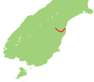
State Highway 82 (SH 82) is a minor east-west South Island state highway in South Canterbury connecting SH 1 at the locality of Hook to SH 83 at the settlement of Kurow in the Waitaki Valley via the major town of Waimate. It is a two lane single carriageway.
Waimate is a town in Canterbury, New Zealand and the seat of Waimate District. It is situated just inland from the eastern coast of the South Island. The town is reached via a short detour west when travelling on State Highway One, the main North/South road. Waimate is 45.7 km south of Timaru, Canterbury's second city, 20 km north of the Waitaki River, which forms the border between Canterbury and the Otago province to the south and 47.5 km north of Oamaru, the main town of the Waitaki District.

Waimate District is a territorial authority district located in the Canterbury Region of the South Island of New Zealand. The main town is Waimate, while there are many smaller rural communities dispersed throughout the area. Its boundary to the south is the Waitaki River, to the west Lake Benmore and to the north-east the Pareora River.
