Hammon, Oklahoma

Last updated

Hammon, Oklahoma
OKMap-doton-Hammon.PNG
Location of Hammon, Oklahoma
Coordinates: 35°37′56″N99°22′53″W / 35.63222°N 99.38139°W / 35.63222; -99.38139
Country United States
State Oklahoma
Counties Roger Mills, Custer
Area
[1]
  Total0.73 sq mi (1.90 km2)
  Land0.73 sq mi (1.90 km2)
  Water0.00 sq mi (0.00 km2)
Elevation
[2]
1,742 ft (531 m)
Population
 (2020)
  Total479
  Density654.37/sq mi (252.65/km2)
Time zone UTC-6 (Central (CST))
  Summer (DST) UTC-5 (CDT)
ZIP code
73650
Area code 580
FIPS code 40-32250 [3]
GNIS feature ID2412722 [2]

Hammon is a town in the U.S. state of Oklahoma, the majority of which is in Roger Mills County, but some of which extends into Custer County. It is located at the junction of Oklahoma State Highways 33 and 34. [4]

Contents

The town is named for Indian agent James H. Hammon, who was assigned to the Red Moon Agency near the future site of Hammon. [5] This was a subagency of the Cheyenne-Arapaho Agency at Darlington, north of Fort Reno, and his mission was to build a reservation school and to teach the Cheyenne and Arapaho to farm. [5] His wife, Ida M. Hammon, was postmaster when a post office was established in their home on June 30, 1894. [5]

The townsite was originally located in Custer County, [5] but when the Wichita Falls and Northwestern Railroad (later known as the Missouri, Kansas and Texas Railway) laid track west of the town in 1910, the majority of the town was moved west into Roger Mills County to be near the railroad. [5] On May 22, 1911, the board of county commissioners accepted the incorporation of the town. [5]

The population was 479 at the time of the 2020 census. [6]

Geography

According to the United States Census Bureau, the town has a total area of 0.7 square miles (1.9 km2), all land.

Hammon is located southwest of the intersection of State Highway 33 and State Highway 34 [4] in Southwestern Oklahoma, known for Oklahoma Tourism purposes as Great Plains Country. [7] The town is just west of the Washita National Wildlife Refuge, and just east of the Black Kettle National Grassland. [4]

Climate

Climate data for Hammon, Oklahoma
MonthJanFebMarAprMayJunJulAugSepOctNovDecYear
Mean daily maximum °F (°C)48
(9)
53
(12)
62
(17)
71
(22)
78
(26)
89
(32)
95
(35)
93
(34)
86
(30)
73
(23)
60
(16)
50
(10)
72
(22)
Mean daily minimum °F (°C)23
(−5)
28
(−2)
32
(0)
42
(6)
53
(12)
62
(17)
68
(20)
66
(19)
57
(14)
44
(7)
32
(0)
26
(−3)
44
(7)
Average precipitation inches (mm)0.8
(20)
1.0
(25)
1.7
(43)
2.5
(64)
4.2
(110)
3.6
(91)
2.1
(53)
2.6
(66)
3.0
(76)
2.3
(58)
1.6
(41)
1.0
(25)
26.1
(660)
Source 1: weather.com
Source 2: Weatherbase.com [8]

Demographics

Historical population
CensusPop.Note
1920 440
1930 73667.3%
1940 705−4.2%
1950 621−11.9%
1960 6565.6%
1970 6773.2%
1980 86627.9%
1990 611−29.4%
2000 469−23.2%
2010 56821.1%
2020 479−15.7%
U.S. Decennial Census [9]

As of the census [3] of 2000, there were 469 people, 169 households, and 114 families residing in the town. The population density was 637.0 inhabitants per square mile (245.9/km2). There were 203 housing units at an average density of 275.7 per square mile (106.4/km2). The racial makeup of the town was 60.77% White, 0.64% African American, 34.54% Native American, 0.21% Asian, 1.71% from other races, and 2.13% from two or more races. Hispanic or Latino of any race were 5.76% of the population.

There were 169 households, out of which 33.7% had children under the age of 18 living with them, 47.3% were married couples living together, 16.6% had a female householder with no husband present, and 32.0% were non-families. 29.0% of all households were made up of individuals, and 13.6% had someone living alone who was 65 years of age or older. The average household size was 2.78 and the average family size was 3.49.

In the town, the population was spread out, with 29.9% under the age of 18, 10.0% from 18 to 24, 28.6% from 25 to 44, 21.3% from 45 to 64, and 10.2% who were 65 years of age or older. The median age was 34 years. For every 100 females, there were 108.4 males. For every 100 females age 18 and over, there were 101.8 males.

The median income for a household in the town was $22,604, and the median income for a family was $28,036. Males had a median income of $22,250 versus $20,500 for females. The per capita income for the town was $10,184. About 31.5% of families and 34.8% of the population were below the poverty line, including 44.8% of those under age 18 and 19.5% of those age 65 or over.

Education

Historic Locations

Three NRHP listings are in or around Hammon:

Notable people

Related Research Articles

<span class="mw-page-title-main">Washita County, Oklahoma</span> County in Oklahoma, United States

Washita County is a county located in the U.S. state of Oklahoma. As of the 2020 census, the population was 10,924. Its county seat is New Cordell. The county seat was formerly located in Cloud Chief. The county was created in 1891.

<span class="mw-page-title-main">Roger Mills County, Oklahoma</span> County in Oklahoma, United States

Roger Mills County is a county located in the western part of the U.S. state of Oklahoma. As of the 2020 census, the population was 3,442, making it the fourth-least populous county in Oklahoma. Its county seat is Cheyenne. The county was created in 1891.

<span class="mw-page-title-main">Ellis County, Oklahoma</span> County in Oklahoma, United States

Ellis County is a county located on the western border of the U.S. state of Oklahoma. As of the 2020 census, the population was 3,749, making it the fifth-least populous county in Oklahoma. Its county seat is Arnett.

<span class="mw-page-title-main">Dewey County, Oklahoma</span> County in Oklahoma, United States

Dewey County is a county in the western part of the U.S. state of Oklahoma. As of the 2020 census, the population was 4,484. Its county seat is Taloga. The county was created in 1891 as "County D". In an 1898 election, county voters chose the name Dewey, honoring Admiral George Dewey.

<span class="mw-page-title-main">Custer County, Oklahoma</span> County in Oklahoma, United States

Custer County is a county located in the U.S. state of Oklahoma. As of the 2020 census, the population was 28,513. Its county seat is Arapaho. The county was named in honor of General George Armstrong Custer.

<span class="mw-page-title-main">Blaine County, Oklahoma</span> County in Oklahoma, United States

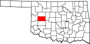
Blaine County is a county located in the U.S. state of Oklahoma. As of the 2020 census, the population was 8,735. Its county seat is Watonga. Part of the Cheyenne-Arapaho land opening in 1892, the county had gained rail lines by the early 1900s and highways by the 1930s. The county was named for James G. Blaine, an American politician who was the Republican presidential candidate in 1884 and Secretary of State under President Benjamin Harrison.

<span class="mw-page-title-main">Beckham County, Oklahoma</span> County in Oklahoma, United States

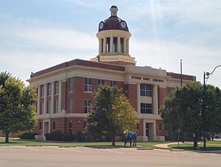
Beckham County is a county located on the western border of the U.S. state of Oklahoma. As of the 2020 census, the population was 22,410. Its county seat is Sayre. Founded upon statehood in 1907, Beckham County was named for J. C. W. Beckham, who was Governor of Kentucky and the first popularly elected member of the United States Senate from Kentucky. Beckham County comprises the Elk City, OK Micropolitan Statistical Area.
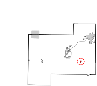
<span class="mw-page-title-main">Powder River County, Montana</span> County in Montana, United States

Powder River County is a county in the U.S. state of Montana. As of the 2020 census, the population was 1,694. Its county seat is Broadus.

<span class="mw-page-title-main">Peeples Valley, Arizona</span> CDP in Yavapai County, Arizona

Peeples Valley is a census-designated place (CDP) in Yavapai County, Arizona, United States. The population was 374 at the 2000 census.

<span class="mw-page-title-main">Elk City, Oklahoma</span> City in Oklahoma, United States

Elk City is a city in Beckham County, Oklahoma, United States. The population was 11,561 at the time of the 2020 census, a slight decrease from the 11,693 figure of the 2010 census. Elk City is located on Interstate 40 and Historic U.S. Route 66 in western Oklahoma, approximately 110 miles (180 km) west of Oklahoma City and 150 miles (240 km) east of Amarillo, Texas.

<span class="mw-page-title-main">Sayre, Oklahoma</span> City in Oklahoma, United States

Sayre is a city in, and the county seat of, Beckham County, in western Oklahoma, United States. It is halfway between Oklahoma City and Amarillo, Texas on Interstate 40 and the former U.S. Route 66. The population was 4,809 at the time of the 2020 census, an increase over the 4,375 figure from the 2010 census, and the largest population ever recorded by a census since Sayre's founding.

<span class="mw-page-title-main">Calumet, Oklahoma</span> Town in Oklahoma, United States

Calumet is a town in Canadian County, Oklahoma, United States. It is part of the Oklahoma City Metropolitan Area. The population was 507 at the 2010 census, a 5.23 percent decrease since 2000.

<span class="mw-page-title-main">Arapaho, Oklahoma</span> Town in Oklahoma, United States

Arapaho is a town in, and the county seat of, Custer County, Oklahoma, United States. The population was 668 at the time of the 2020 census. The town lies long U.S. Route 183 and is named for the Arapaho Native American tribe.

<span class="mw-page-title-main">Butler, Oklahoma</span> Town in Oklahoma, United States

Butler is a town in Custer County, Oklahoma, United States. The population was 208 at the time of the 2020 census, down from 287 at the 2010 census.

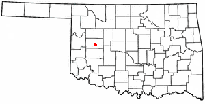
Custer City is a town in Custer County, Oklahoma, United States. Custer City is northeast of Clinton and northwest of Weatherford along Oklahoma 33. The population was 367 at the time of the 2020 census.

Weatherford is a city in Custer County, Oklahoma, United States. The population was 12,076 at the time of the 2020 census, a gain of about 11.5% over the 10,833 figure from the 2010 census.

<span class="mw-page-title-main">Porter, Oklahoma</span> Town in Oklahoma, United States

Porter is a town in Wagoner County, Oklahoma, United States. It promotes itself as "The Peach Capital of Oklahoma." The population was 566 at the 2010 census, a loss of 1.4 percent, compared to 574 at the 2000 census.

<span class="mw-page-title-main">Sentinel, Oklahoma</span> Town in Oklahoma, United States

Sentinel is a town in Washita County, in the U.S. state of Oklahoma. The population was 901 in the 2010 census, an increase of 4.9 percent from the figure of 859 residents in 2000. Towns near Sentinel are Rocky, Cordell, Canute, and Burnsflat.

<span class="mw-page-title-main">Tinmouth, Vermont</span> Town in Vermont, United States

Tinmouth is a town in Rutland County, Vermont, United States. The population was 553 at the 2020 census.

<span class="mw-page-title-main">Okarche, Oklahoma</span> Town in Oklahoma, United States

Okarche is a town in Canadian and Kingfisher counties in Oklahoma, United States, that is part of the Oklahoma City Metropolitan Area. The population was 1,141 as of the 2020 United States census.

References

  1. "ArcGIS REST Services Directory". United States Census Bureau. Retrieved September 20, 2022.
  2. 1 2 U.S. Geological Survey Geographic Names Information System: Hammon, Oklahoma
  3. 1 2 "U.S. Census website". United States Census Bureau . Retrieved January 31, 2008.
  4. 1 2 3 "Hammon, Oklahoma". Google Maps. Retrieved October 14, 2019.
  5. 1 2 3 4 5 6 "Hammon". Oklahoma Historical Society. Retrieved October 14, 2019.
  6. "Hammon (town), Oklahoma". US Census Bureau. Retrieved October 16, 2023.
  7. "Maps (see Counties and Regions)". Oklahoma Department of Tourism and Recreation. Retrieved October 14, 2019.
  8. "Historical Weather for Hammon, Oklahoma, United States".
  9. "Census of Population and Housing". Census.gov. Retrieved June 4, 2015.
  10. 1 2 "Roger Mills County". Linda D. Wilson, Oklahoma Historical Society. Retrieved February 17, 2020.
  11. "Arizona State Library, Arizona Legislators: Then & Now-Bessie Stinson". Archived from the original on June 30, 2016. Retrieved May 9, 2016.