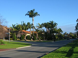
Carine is a suburb of Perth, the capital city of Western Australia, and is located 14 kilometres (9 mi) north of Perth's central business district (CBD) between Marmion Avenue and Mitchell Freeway. Its local government area is the City of Stirling.

Marion is a suburb in the City of Marion, around 10 kilometres (6.2 mi) south-west of the city centre of Adelaide, the capital of South Australia. Founded as a rural village in 1838 on the banks of the Sturt River, Marion was found to have rich soil and the population expanded rapidly. Colonel William Light laid out the plan for the village, as he had done with the City of Adelaide itself.

Para Hills is a residential suburb of Adelaide, South Australia. There is a light aircraft airport close to its boundary, and numerous sporting facilities, abundant parks and schools and two medium-sized shopping centres. Most of the suburb is in the City of Salisbury while some is in the City of Tea Tree Gully.

Prospect is the seat of the City of Prospect and an inner northern suburb of greater Adelaide. It is located 5 km (3.1 mi) north of Adelaide's centre.

Enfield is a suburb in Adelaide, Australia. The suburb is about a 10-minute drive north from Adelaide city centre. The suburb is bordered by Gepps Cross to the north, Blair Athol to the west, Clearview to the east, and Prospect, Sefton Park and Broadview to the south.

Toorak Gardens is a leafy, mainly residential inner eastern suburb of Adelaide, South Australia, located 2 km east of the Adelaide city centre.

Stepney is a small triangular near-city suburb of Adelaide within the City of Norwood Payneham & St Peters. Stepney contains a mix of retail, manufacturing, professional services and distribution outlets within a cosmopolitan population strongly influenced by post World War II immigration.

Clovelly Park is an inner southern suburb of Adelaide in the local government area of the City of Marion. Before becoming an 'advanced' suburb, it was a farm and vineyard. The suburb is bordered by Daws Road to the north, South Road to the east, Sturt Road to the south, and a combination of Percy Avenue and the Flinders railway line to the west. It is situated approximately 20 minutes from the Adelaide city centre, and about 2 minutes from Flinders University, Flinders Medical Centre and Westfield Marion.

Woodville Gardens is a north-western suburb of Adelaide 9 km from the CBD, in the state of South Australia, Australia and falls under the City of Port Adelaide Enfield. It is adjacent to Woodville North, Mansfield Park, Ferryden Park, and Kilkenny. The post code for Woodville Gardens is 5012. It is bounded to the south by First Avenue, and to the east by Liberty Grove, and to the west by Hanson Road.

Woodville North is a north-western suburb of Adelaide 10 km from the Adelaide city centre, in the state of South Australia, Australia and falls under the City of Charles Sturt. The post code for Woodville North is 5012. It is adjacent to Pennington, Athol Park, Woodville Gardens, Mansfield Park, Woodville and Kilkenny. It is bordered to the east by Hanson Road to the west by Carlton Crescent, to the south by Torrens Road and to the north by Hamilton Road. The suburb is residential, apart from an industrial pocket to the northwest.

North Haven is a north-western suburb of Adelaide, in the state of South Australia, Australia. It is located 20km from the Central Business District (CBD), and falls under the City of Port Adelaide Enfield. It is adjacent to Osborne and Outer Harbour. It is bounded to the north and east by Oliver Rogers and Victoria Road, to the south by Marmora Terrace and to the west by Gulf St Vincent. The postal code for North Haven is 5018.

Croydon Park is a north-western suburb of Adelaide 5.9 km from the CBD, in the state of South Australia, Australia and is within the City of Port Adelaide Enfield. It is adjacent to Dudley Park, Devon Park, Renown Park, Regency Park, Ferryden Park Kilkenny, and West Croydon. The post code for Croydon Park is 5008. It is bounded to the south by Lamont Street and Torrens Road, to the north by Regency Road and in the east and west by Harrison Road and Goodall Avenue respectively. Croydon Park is predominantly a residential suburb, with a warehousing presence on the northern edges near Regency Road. Croydon Park has been completely divided by the North-South Motorway.

Northgate is a suburb in the inner north-east of Adelaide, South Australia. It is approximately a 10-minute drive from the Adelaide City Council.
Cumberland Park is an inner-southern suburb of Adelaide, South Australia in the City of Mitcham.

St Marys is a suburb of Adelaide, South Australia, located to the south of the Central Business District. It is bordered by Daws Road (north), South Road (west), Cashel Street (east) and Mill Terrace (south). The suburb is located within the City of Mitcham local government authority. St Marys Park is one of the largest reserves within the suburb and was originally the training ground of the South Adelaide Football Club.

Greenacres is a north eastern suburb of Adelaide, South Australia in the City of Port Adelaide Enfield. It is considered to be an inner suburb of greater Adelaide. Hampstead Road and Muller Road intersect at the south west corner of Greenacres making it a bustling area during rush hour. These form the western and southern boundaries of the suburb, with Fosters Road on the east and Redward Avenue on the northern boundary. Greenacres is home to the Greenacres Shopping Centre, which has as its major shops a Coles supermarket, The Reject Shop and formerly Sam's Warehouse. The City of Port Adelaide Enfield Greenacres Library & Office is located to the east of the shopping centre precinct. The suburb also features Hampstead Barracks, a small suburban Australian Army base.

Collinswood is a suburb of Adelaide spanning the boundary of the Prospect and the Port Adelaide Enfield local government areas.

Manningham is a suburb in the inner north-eastern suburbs of Adelaide, the capital of South Australia. It is around 5 km from the city centre, in the City of Port Adelaide Enfield council area.
Regency Road is a main east-west road forming a continuous connection between the inner northern suburbs of Adelaide, South Australia. Located approximately 6 kilometres (3.7 mi) north of the city centre, Regency Road carries a large amount of freight traffic, being located near Regency Park and the Churchill Road industrial area.

Lightsview is a suburb in the City of Port Adelaide Enfield. It was created in April 2016 from parts of Northgate, Greenacres and Northfield. It is in the inner northeast, bounded by Hampstead Road, Redward Avenue, Fosters Road and Folland Avenue.


