Diré Cercle is an administrative subdivision of the Tombouctou Region of Mali. The administrative center (chef-lieu) is the town of Diré.

Niafunké Cercle is an administrative subdivision of the Tombouctou Region of Mali. The administrative center (chef-lieu) is the town of Niafunké. In the 2009 census the cercle had a population of 184,285. The Niger River runs for 100 km through the cercle.
Diouna is a village and rural commune in the Cercle of Ségou in the Ségou Region of southern-central Mali. The commune includes 11 villages in an area of approximately 175 square kilometers. In the 2009 census it had a population of 9,244. The chef-lieu of the commune is the village of Diouna which lies 49 km east of Ségou.
Saminé is a small town and rural commune in the Cercle of Ségou in the Ségou Region of southern-central Mali. The commune includes the town and 5 villages in an area of approximately 197 square kilometers. In the 2009 census it had a population of 12,082. The Bani River runs along the southern boundary of the commune. The town of Saminé, the chef-lieu of the commune, is 41 km south-southeast of Ségou.
Togou is a village and rural commune in the Cercle of Ségou in the Ségou Region of southern-central Mali. The commune contains 10 villages in an area of approximate 147 square kilometers. In the 2009 census it had a population of 8,987. The village of Togou, the chef-lieu of the commune, is 35 km northeast of Ségou.
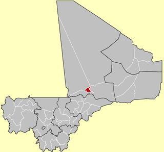
Diganibougou or Diganidougou is a rural commune in the Cercle of Ségou in the Ségou Region of Mali. The commune lies to the north of the Niger River opposite the urban commune of Ségou and includes 22 villages in an area of approximately 571 square kilometers. In the 2009 census the commune had a population of 13,879. The administrative center (chef-lieu) is the village of Digani.
Kamiandougou is a rural commune in the Cercle of Ségou in the Ségou Region of Mali. The commune contains 18 villages in an area of approximately 311 square kilometers. In the 2009 census it had a population of 14313. The administrative center (chef-lieu) is the village of Nonongo which lies 94 km east-northeast of Ségou.
Baguindadougou is a rural commune in the Cercle of Ségou in the Ségou Region of Mali. The commune includes 14 villages in an area of approximately 702 square kilometers. In the 2009 census it had a population was 10,371. The administrative center (chef-lieu) is the village of Markanibougou.
N'Koumandougou is a rural commune in the Cercle of Ségou in the Ségou Region of Mali. The commune contains 15 villages in an area of approximately 2,040 square kilometers. In the 2009 census it had a population of 14,237. The chef-lieu is the village of Doura.
Bellen is a rural commune in the Cercle of Ségou in the Ségou Region of Mali. It is the most northerly within the cercle and is sparsely populated with only 9 villages in an area of approximately 3,189 square kilometers. In the 2009 census it had a population of 6,949. The chef-lieu is the village of Sagala which lies 89 km northwest of Ségou.
Toridaga-Ko is a rural commune in the Cercle of Niono in the Ségou Region of Mali. The commune covers an area of approximately 653 square kilometers and includes 18 villages. In the 2009 census the population was 26,901. The administrative center (chef-lieu) is the village of Bolibana which lies 20 km north of Niono.
Metoumou is a commune in the Cercle of Bandigara of the Mopti Region of Mali. The commune contains 22 villages and in the 2009 census had a population of 13,940. The main village (chef-lieu) is Damada.
Pignari Bana is a commune in the Bandiagara Cercle in the Mopti Region of Mali. The commune contains 23 villages and in the 2009 census had a population of 28,258. The main village (chef-lieu) is Goundaka.
Pignari is a commune in the Cercle of Bandigara in the Mopti Region of Mali. The commune contains 19 villages and in the 2009 census had a population of 14,630. The main village (chef-lieu) is Baboye.
Koubewel Koundia is a rural commune in the Cercle of Douentza in the Mopti Region of Mali. The commune contains 14 villages and had a population of 13,529 in the 2009 census. The main village (chef-lieu) is Koubewel.
Dangol Boré is a rural commune of the Cercle of Douentza in the Mopti Region of Mali. The commune contains 34 villages and in the 2009 census had a population of 27,165. The principal village (chef-lieu) is Boré.
Djaptodji is a rural commune of the Cercle of Douentza in the Mopti Region of Mali. The commune contains 64 small villages and in the 2009 census had a population of 36,263. The principal village (chef-lieu) is N'Gouma.
Gandamia is a rural commune of the Cercle of Douentza in the Mopti Region of Mali. The commune contains eight villages and in the 2009 census had a population of 7,215. The chef-lieu is the small village of Kikara.
Ouinderden is a rural commune of the Cercle of Gourma-Rharous in the Tombouctou Region of Mali. The seat lies at Adiora. The commune contains 28 small villages and in the 2009 census had a population of 6,105, nearly all of whom are nomadic pastoralists.
Hanzakoma or Hamzakoma is a rural commune of the Cercle of Gourma-Rharous in the Tombouctou Region of Mali. The commune contains 19 villages and in the 2009 census had a population of 7,929. The principal village (chef-lieu) is Minkiri.

