
Gossi is a town and rural commune in the Cercle of Gourma-Rharous of the Tombouctou Region of Mali, lying northeast of Hombori and southwest of Gao. The town is just to the west of the main RN15 highway that links Mopti with Gao. It is on a seasonal lake, Mare de Gossi, and is surrounded by nature reserves in which a large herd of elephants live. The town is the site of a large cattle market. The commune contains around 31 villages and in the 2009 census, it had a population of 24,521. Most of the population are nomadic pastoralists but there are permanent settlements around Lake Gossi, Lake Ebanguemalène and Lake Agoufou.
Diré Cercle is an administrative subdivision of the Tombouctou Region of Mali. The administrative center (chef-lieu) is the town of Diré.

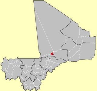
Gourma-Rharous Cercle is an administrative subdivision of the Tombouctou Region of Mali. The administrative center is the town of Gourma-Rharous.

Niafunké Cercle is an administrative subdivision of the Tombouctou Region of Mali. The administrative center (chef-lieu) is the town of Niafunké. In the 2009 census the cercle had a population of 184,285. The Niger River runs for 100 km through the cercle.

Timbuktu Cercle is an administrative subdivision of the Tombouctou Region of Mali. It is the largest cercle by area in the whole of Mali. The capital lies at the city of Timbuktu. The cercle is divided into Rural and Urban Communes, and below this, quarters/villages. In the 2009 census the cercle had a population of 124,546.
Pelou is a village and rural commune in the Cercle of Bandiagara of the Mopti Region of Mali. The commune contains four villages and in the 2009 census had a population of 4,348.
Kendié is a village and rural commune in the Cercle of Bandiagara of the Mopti Region of Mali. The commune contains 34 villages and had a population of 24,359 in the 2009 census.
Pignari Bana is a commune in the Cercle of Bandigara in the Mopti Region of Mali. The commune contains 23 villages and in the 2009 census had a population of 28,258. The main village (chef-lieu) is Goundaka.
Pignari is a commune in the Cercle of Bandigara in the Mopti Region of Mali. The commune contains 19 villages and in the 2009 census had a population of 14,630. The main village (chef-lieu) is Baboye.
Débéré is a village and rural commune in the Cercle of Douentza in the Mopti Region of Mali. The commune contains seven villages and in the 2009 census had a population of 5,760.
Kéréna is a village and rural commune in the Cercle of Douentza in the Mopti Region of Mali. The commune contains three villages and in the 2009 census had a population of 3,289.
Djaptodji is a rural commune of the Cercle of Douentza in the Mopti Region of Mali. The commune contains 64 small villages and in the 2009 census had a population of 36,263. The principal village (chef-lieu) is N'Gouma.
Gandamia is a rural commune of the Cercle of Douentza in the Mopti Region of Mali. The commune contains eight villages and in the 2009 census had a population of 7,215. The chef-lieu is the small village of Kikara.
Korarou is a rural commune of the Cercle of Douentza in the Mopti Region of Mali. The commune contains nine villages and according to the 2009 census, it has a population of 3,539. The principal village (chef-lieu) is Diona.

Bambara Maoudé or Bambara Maoundé is a village and rural commune of the Cercle of Gourma-Rharous in the Tombouctou Region of Mali. The commune contains 44 villages and had a population of 16,874 in the 2009 census.
Banikane is a village and commune of the Cercle of Gourma-Rharous in the Tombouctou Region of Mali. The village lies on the right bank of the River Niger, 25 km downstream of Rharous. The commune extends on both banks of the river and includes 15 villages. In the 2009 census the population of the commune was 9,433.
Inadiatafane is a village and commune of the Cercle of Gourma-Rharous in the Tombouctou Region of Mali. The commune contains 25 villages and in the 2009 census had a population of 3,557.
Léré is a small town and rural commune of the Cercle of Niafunké in the Tombouctou Region of Mali. The commune covers an area of approximately 1,342 square kilometers and contains the town and 18 villages. In the 2009 census the commune had a population of 16,072.
Haribomo is a rural commune of the Cercle of Gourma-Rharous in the Tombouctou Region of Mali. The commune contains 29 villages and in the 2009 census had a population of 7,389. The principal village (chef-lieu) is Daka Fifo.
Hanzakoma or Hamzakoma is a rural commune of the Cercle of Gourma-Rharous in the Tombouctou Region of Mali. The commune contains 19 villages and in the 2009 census had a population of 7,929. The principal village (chef-lieu) is Minkiri.

