Harike

Last updated

Harike
HARIKE wetlands.jpg
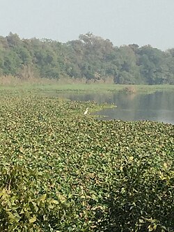
Harike Wetland in Harike (Tarn Taran district, Punjab)
Harike
India Punjab location map.svg
Red pog.svg
Harike
Location in Punjab, India
India location map.svg
Red pog.svg
Harike
Harike (India)
Coordinates: 31°09′59″N74°56′30″E / 31.1663°N 74.9418°E / 31.1663; 74.9418
Country Flag of India.svg  India
State Punjab
District Tarn Taran
Area
  Total9.43 km2 (3.64 sq mi)
Elevation
210 m (690 ft)
Population
 (2011)
  Total8,662
  Density920/km2 (2,400/sq mi)
Languages
  Official Punjabi
Time zone UTC+5:30 (IST)
PIN Code
143412
Vehicle registration PB 38

Harike is a village in Patti Tehsil in Tarn Taran district of the Indian state of Punjab. It is located 33 km from Tarn Taran Sahib city. The PIN code of Wakro is 143412. [1] Harike is connected by two national highways, National Highway 54 and National Highway 703B.

Contents

Demographics

As per 2011 Census of India, total number of households in Harike was 1620 and total population was 8,662 persons. There were total of 4,666 males and 3,996 females. There were 1,136 children of 6 years or below in Harike in 2011. The percentage of male population was 53.8% and the percentage of female population was 46.2%. Average Sex Ratio of Harike is 856 which is lower than Punjab state average of 895. [2]

Harike bird sanctuary

Harike barrage and Harike Wetland which are named after Harike village are located near this village. Migratory birds flock to this protected largest wetland in North India in winters. [3] [4]

Related Research Articles

<span class="mw-page-title-main">Tarn Taran Sahib</span> City in Punjab, India

Tarn Taran Sahib is a city in the Majha region of the state of Punjab, in northern India. It is the district headquarters and hosts the municipal council of Tarn Taran district. Gurdwara Sri Tarn Taran Sahib, a prominent Sikh shrine is located in the central part of the city.

Khem Karan is a town and a nagar panchayat in Tarn Taran district of Patti tehsil of the Majha region of the Indian state of Punjab.

<span class="mw-page-title-main">Rupnagar</span> City in Punjab, India

Rupnagar is a city and a municipal council in Rupnagar district in the Indian state of Punjab. Rupnagar is a newly created fifth Divisional Headquarters of Punjab comprising Rupnagar, Mohali, and its adjoining districts. It is also one of the bigger sites belonging to the Indus Valley civilization. Rupnagar is nearly 43 km (27 mi) to the northwest of Chandigarh. It is bordered by Himachal Pradesh to the north and Shahid Bhagat Singh Nagar district to its west.

Bhikhiwind is a town and a nagar panchayat, just about 33 km from Tarn Taran Sahib in Tarn Taran district in the Majha region of state of Punjab, India. The town is located along the India-Pakistan border in Tarn Taran district of Punjab, India, 280 km from Chandigarh.

<span class="mw-page-title-main">Dadri</span> Town in Uttar Pradesh, India

Dadri is a town and a municipal board in Gautam Buddha Nagar District in the state of Uttar Pradesh, India. Noida, Dadri and Jewar are the 3 sub-divisions of GB Nagar district, each headed by a SDM.

<span class="mw-page-title-main">Makhu</span> Town in Punjab, India

Makhu is a town and a nagar panchayat in Ferozepur district in Indian state of Punjab.

<span class="mw-page-title-main">Tarn Taran district</span> District of Punjab in India

Tarn Taran district is one of the districts in the Majha region of Punjab, India. The main cities are Tarn Taran Sahib, Bhikhiwind, Khadur Sahib and Patti. The City of Tarn Taran Sahib is a holy place for Sikhs.

<span class="mw-page-title-main">Raiganj Wildlife Sanctuary</span> Wildlife sanctuary in India

Raiganj Wildlife Sanctuary is situated near Raiganj in Uttar Dinajpur district in the Indian state of West Bengal. The bird sanctuary is home to 164 species of birds, and some 90,000 to 100,000 migratory birds visit the sanctuary every year. As per the MEE report, West Bengal''s Jaldapara national park and Raiganj wildlife sanctuary, Himachal Pradesh''s Sainj and Tirthan wildlife sanctuaries as well as the Great Himalayan national park have been declared as top five national parks and wildlife sanctuaries in India.

Patti is an old city, near Tarn Taran Sahib city and a municipal council of the Tarn Taran district in the Majha region of Indian state of Punjab, located 47 Kilometres from Amritsar. Patti city is situated close to the Pakistani border. It is connected through a rail network starting from Amritsar station to Khem Karan station, with Khem Karan being its last station of India.

Kanjli Wetland is a man-made Wetland that subsumes the Kanjli Lake, and is located in the Kapurthala district of Punjab state in India. It was created in 1870 by constructing the headworks across the perennial Bien River, a tributary of the Beas River to provide irrigation facilities to the hinterland. The rich biodiversity of the wetland comprising aquatic, mesophytic and terrestrial flora and fauna including some important species of plants and animals was recognized internationally by the Ramsar Convention in 2002 by designating the Kanjli Lake in the List of Wetlands of International Importance. In this context, it is reported that the Punjab State which has 14 wetlands covering an area of 225.76 km2 has the unique position of three of its wetlands viz., the Kanjli Wetland covering an area of 490 ha of which the Kanjli Lake water spread is 184 ha), the Harike Wetland and the Ropar Wetland chosen by the Ministry of Environment and Forest (MoE&F), Government of India for their conservation and management are now also included in the Ramsar list covering a total area of 5650 ha; Kanjli is upstream of Harike wetland located in the Beas river basin while the Ropar wetland is in the Roopnagar district.

<span class="mw-page-title-main">Harike Wetland</span> Largest wetland in northern India

Harike Wetland also known as "Hari-ke-Pattan", with the Harike Lake in the deeper part of it, is the largest wetland in northern India in the border of Tarn Taran Sahib district and Ferozepur district of the Punjab state in India.

<span class="mw-page-title-main">Punjab, India</span> State in northern India

Punjab, historically known as Panchanada or Pentapotamia, is a state in northern India. Forming part of the larger Punjab region of the Indian subcontinent, the state is bordered by the Indian states of Himachal Pradesh to the north and northeast, Haryana to the south and southeast, and Rajasthan to the southwest; by the Indian union territories of Chandigarh to the east and Jammu and Kashmir to the north. It shares an international border with Punjab, a province of Pakistan to the west. The state covers an area of 50,362 square kilometres, which is 1.53% of India's total geographical area, making it the 19th-largest Indian state by area out of 28 Indian states. With over 27 million inhabitants, Punjab is the 16th-largest Indian state by population, comprising 23 districts. Punjabi, written in the Gurmukhi script, is the most widely spoken and the official language of the state. The main ethnic group are the Punjabis, with Sikhs (57.7%) and Hindus (38.5%) forming the dominant religious groups. The state capital is Chandigarh, a union territory and also the capital of the neighbouring state of Haryana. Three tributaries of the Indus, viz., Sutlej, Beas, and Ravi, flow through Punjab.

Fatehabad is a small town in the Tarn Taran district of Punjab State. in India, located about 20 km from Tarn Taran Sahib

<span class="mw-page-title-main">Kotli Saru Khan</span> Village in Punjab, India

Kotli Saru Khan is a village in Khadur Sahib in Tarn Taran district of Punjab State, India. It is located 1 kilometre (0.62 mi) from sub district headquarter and 15 kilometres (9.3 mi) from district headquarter. The village is administrated by Sarpanch an elected representative of the village.

<span class="mw-page-title-main">Outline of Punjab, India</span> Overview of and topical guide to Punjab, India

The following outline is provided as an overview of and topical guide to Punjab:

<span class="mw-page-title-main">Khalra</span> Village in Punjab, India

Khalra village is located in Patti Tehsil of Tarn Taran district in Punjab, India. It is situated 27 km away from sub-district headquarter Patti and 35 km away from district headquarter Tarn Taran. According to Census 2011 information the village code of Khalra village is 038051.

Arifke or Arif Ke, is a village in Firozepur tehsil of the Firozpur district in Punjab, India. Arifke is located on the junction of new national highways NH 354 and NH 703A.

Chung is a historical village of Bhikhiwind town in the Indian state of Punjab. Before 1947, it was part of Kasur tehsil of Lahore district. Rice and wheat are the most cultivated crops.

Khadur Sahib is a town and a nagar panchayat in Tarn Taran district of Khadur Sahib tehsil of the Majha region of Indian state of Punjab. Khadur Sahib is a historical place in view of eight out of ten sikh gurus having visited this place. The postal index number of Khadur Sahib is 143117.

Chohla Sahib is a town and a nagar panchayat in Tarn Taran district of the Majha region of Indian state of Punjab. This town is located in Chohla Sahib development block. Chohla Sahib is a historical place in view of two sikh gurus having visited this place. The postal index number of Chohla Sahib is 143408.

References

  1. "Postal code of Harike village" . Retrieved 2 November 2019.
  2. "Harike village census details (2011)". Census of India . Retrieved 2 November 2019.
  3. "Quick Guide: Harike Bird Sanctuary, Punjab". Outlook (Indian magazine) . Retrieved 2 November 2019.
  4. "Migratory birds start flocking Harike". The Tribune India . 26 October 2019. Retrieved 2 November 2019.