Shaheed Bhagat Singh Nagar district

Last updated

Shaheed Bhagat Singh Nagar
Nawanshahr
Guru Teg Bhadur Gate Banga - panoramio.jpg
Guru Teg Bahadur Gate in Banga
Shahid Bhagat Singh Nagar in Punjab (India).svg
Location in Punjab
Coordinates: 31°7′31″N76°6′59″E / 31.12528°N 76.11639°E / 31.12528; 76.11639
CountryFlag of India.svg  India
State Punjab
Region of Punjab Doaba
Named for Bhagat Singh
Headquarters Nawanshahr
Government
  Deputy Commissioner Navjot Pal Singh Randhawa
Area
  Total1,266 km2 (489 sq mi)
Population
 (2011) []
  Total612,310
  Density480/km2 (1,300/sq mi)
Languages
  Official Punjabi
Time zone UTC+5:30 (IST)
Telephone code01823 for Nawanshahr and Banga
01885 for Balachaur
Literacy80.3%
Website nawanshahr.nic.in

Shaheed Bhagat Singh Nagar district is one of twenty-three districts of state of Punjab, India. It is located in Doaba region. It consists of three subdivisions, Nawanshahr, Banga, and Balachaur. There are three legislative seats in the district, Nawanshahr, Balachaur and Banga. They fall under the Anandpur Sahib Lok Sabha Constituency. Nawanshahr, the district headquarters is about 92 kilometres (57 mi) from Chandigarh, the state's capital. [1]

Contents

As of 2011, it is the third least populous district of Punjab (out of 22), after Barnala and Fatehgarh Sahib. [2]

History

Shaheed Bhagat Singh Nagar district was formed from the Hoshiarpur and Jalandhar districts of Punjab on 7 November 1995, as the sixteenth district of Punjab State named from the headquarters town of Nawanshahr. Nawanshahr was founded by the migrants from Rahon near the Sutlej River as Rahon was in danger of being flooded. They named it Nawanshahar (meaning "New City"). Nawanshahr has been the stronghold of the Ghorewaha Rajputs allied to king Akbar via kinship ties.

Dewan Banna Mal Misr (Gautam) was born in Gautam Brahmin (Shori Gotra) family of Nawanshahr. He was son of Vaid Jhanda Mal of Nawanshahr, Dewan Banna Mal was manager with full sovereign powers of His Highness Maharaja Sir Randhir Singh Bahadur of Kapurthala's Estates in Oudh and served as Chief Minister Of Kapurthala State. Dewan Banna Mal built the temple Shivala Banna Mal near the Municipal Committee office, Nawanshahr. It was built in the year 1862 and tall and huge structure Haveli Banna Mal Di Haveli in Vaidan Mohalla in Nawanshahr. Dewan Banna Mal's sons Dewan Acchru Mal Gautam (Revenue Minister) and Dewan Sundri Mal Gautam (Revenue Minister) of Kapurthala State built Brahmkund Mandir behind Shalimar Bagh in Kapurthala. Dewan Banna Mal owned 3000 acres of land in the Mand area of Kapurthala on the bank of River Beas Bana Malwala after Dewan Banna Mal Gautam's name and Brahampur, Phagwara villages in Tehsil Phagwara. Descendants of Banna Mal Today lives in Kapurthala, Phagwara, New Delhi and Dehradun, Pandit Daljit Parshad Gautam Advocate of Kapurthala Renowned Civil Lawyer of Punjab practices in Kapurthala till his death in the Year 2010, Dewan Ambika Parshad ( Accountant General of Kapurthala State) his daughter Savitri Shori Mahajan a historian was married to The Great Historian of India and A Lawyer Vidya Dhar Mahajan, their daughters Mridula Mukherjee And Sucheta Mahajan are Historian and Working as a Professor of Indian history in JNU New Delhi.

Later, the city was developed and constructed by Lala Paramanand Bhuchar (Sareen) who was the first major scale thekedar of city. Lala Paramanand was given the first mould of large-brick design by Queen Elizabeth in the presence of the Maharaja Patiala in his courtroom as a token of gratitude to establish brick factories (Batha) in the city. Lala Paramanand build first planned Mandi (now known as old Dana Mandi) in around 1920 which even has his name "PN" on bricks and name on Foundation Stone at old Dana Mandi Gate. He resided in Lalliyan Mohalla (Lalleyan da Mohalla) situated in center of city. The mohalla have his Haveli there along with a common haveli which was residence of 100 families, a historical landmark in that mohalla made with Nanakshahi bricks.

Nawanshahr became a district in 1995 during the S. Harcharan Brar government, with strong efforts of the late S. Dilbag Singh, former Cabinet Minister and the then MLA of Nawanshahr. People of this district are economically sound. Many of the district's families have settled abroad. Consequently, much remittance is sent back to India, contributing to the district's economic development and prosperity. The prosperity of Doaba area can be appreciated by the fact that the price of land here is high, and far more than most of the districts in the state except Ludhiana and Chandigarh. Nawanshahr is rising due to the remittances from overseas Punjabis. Nawanshahr is connected to Jalandhar, Rahon and Jaijon by railway.

On 27 September 2008 at Khatkar Kalan, 8 km from Nawanshahr, the Punjab government announced that a district in the state would be named after the freedom fighter Bhagat Singh. The announcement was made by Punjab Chief Minister Parkash Singh Badal to mark the 101st anniversary of Bhagat Singh's birth. As a result, Nawanshahr district was renamed Shaheed Bhagat Singh Nagar. [3]

Geography

Shaheed Bhagat Singh Nagar district is located at 31°48′N76°42′E / 31.8°N 76.7°E / 31.8; 76.7 . [4] The total area is 1,258 square kilometres (km2). [5]

Healthcare

This region has abundant health facilities. There are numerous private clinics and nursing homes. Some of them claim to have the latest medical equipment. There is an adequate number of Government Hospitals, Dispensaries and Primary Health Centers in this area. The hospitals in Nawanshahr have capacity of 64 beds and are equipped with latest medical tools. Banga and Balachaur hospitals have capacities of 30 beds each. Also Mukandpur, Urapar, Sujjon, Saroya and Muzzaffarpur proved a variety of health services. Health services are available for every village in the district. Veterinary hospitals can be found in Nawanshahr, Rahon, Saroya, and Balachaur.

Demographics

Historical population
YearPop.±% p.a.
1901269,801    
1911239,880−1.17%
1921244,966+0.21%
1931278,703+1.30%
1941328,209+1.65%
1951306,122−0.69%
1961332,944+0.84%
1971382,523+1.40%
1981456,434+1.78%
1991531,253+1.53%
2001587,468+1.01%
2011612,310+0.42%
source: [6]

According to the 2011 Census, Shaheed Bhagat Singh Nagar district has a population of 612,310, [2] roughly equal to the nation of Solomon Islands [7] or the US state of Vermont. [8] This gives it a ranking of 522nd in India (out of a total of 640). [2] The district has a population density of 479 inhabitants per square kilometre (1,240/sq mi). [2] Its population growth rate over the decade 2001-2011 was 4.58%. [2] Shaheed Bhagat Singh Nagar has a sex ratio of 954 females for every 1000 males, [2] and a literacy rate of 80.3%. Scheduled Castes made up 42.51% of the population. [2]

Gender

The table below shows the sex ratio of SBS Nagar district through decades.

Sex ratio of SBS Nagar district [9]
Census yearRatio
2011954
2001914
1991900
1981898
1971887
1961900
1951876
1941865
1931848
1921821
1911796
1901856

The table below shows the child sex ratio of children below the age of 6 years in the rural and urban areas of SBS Nagar district.

Child sex ratio of children below the age of 6 years in SBS Nagar district [10]
YearUrbanRural
2011889884
2001804809

Religion

Religion in Shaheed Bhagat Singh Nagar district (2011) [11]
ReligionPercent
Hinduism
65.55%
Sikhism
31.50%
Islam
1.12%
Buddhism
0.96%
Other or not stated
0.87%

The table below shows the population of different religions in absolute numbers in the urban and rural areas of SBS Nagar district.

Absolute numbers of different religious groups in SBS Nagar district [12]
ReligionUrban (2011)Rural (2011)Urban (2001)Rural (2001)
Hindu96,7473,04,62160,4672,96,243
Sikh24,3121,68,57318,5852,01,271
Muslim1,9614,8686453,412
Christian3371,14299520
Other religions2,0597,6901,2704,956

Language

Languages of Shaheed Bhagat Singh Nagar district (2011) [13]

   Punjabi (94.63%)
   Hindi (4.37%)
  Others (1.00%)

In 2022, 94.63% of the population spoke Punjabi and 4.37% Hindi as their first language. [13]

Health

The table below shows the data from the district nutrition profile of children below the age of 5 years, in SBS Nagar, as of year 2020.

District nutrition profile of children under 5 years of age in SBS Nagar, year 2020 [14]
IndicatorsNumber of children (<5 years)Percent (2020)Percent (2016)
Stunted7,75618%23%
Wasted5,17512%16%
Severely wasted2,5646%5%
Underweight4,85011%25%
Overweight/obesity2,8377%3%
Anemia24,84364%76%
Total children43,306

The table below shows the district nutrition profile of SBS Nagar of women between the ages of 15 to 49 years, as of year 2020.

District nutritional profile of SBS Nagar of women of 15-49 years, in 2020 [15]
IndicatorsNumber of women (15-49 years)Percent (2020)Percent (2016)
Underweight (BMI <18.5 kg/m^2)19,43810%13%
Overweight/obesity83,29442%36%
Hypertension65,25233%15%
Diabetes30,12415%NA
Anemia (non-preg)99,52250%65%
Anemia (preg)NANA58%
Total women (preg)9,216
Total women199,363

Politics

No.ConstituencyName of MLAPartyBench
46 Banga (SC) Sukhwinder Kumar Sukhi Shiromani Akali Dal Opposition
47 Nawan Shahr Nachhatar Pal Bahujan Samaj Party Opposition
48 Balachaur Santosh Katariaa Aam Aadmi Party Government

Notable residents

Villages

Karnana

Pharala

Related Research Articles

<span class="mw-page-title-main">Kapurthala</span> City in Punjab, India

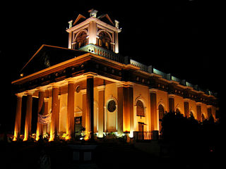
Kapurthala is a city in Punjab state of India. It is the administrative headquarters of Kapurthala District. It was the capital of the Kapurthala State, a princely state in British India. The aesthetic mix of the city with its prominent buildings based on French and Indo-Saracenic architecture self-narrate its princely past. It is also known as city of Palaces & Gardens. According to the 2011 census, Kapurthala is the least populated city in India.

<span class="mw-page-title-main">Doaba</span> Region of Punjab, India

Doaba, also known as Bist Doab or the Jalandhar Doab, is the region of Punjab, India that lies between the Beas River and the Sutlej River. People of this region are given the demonym "Doabia". The dialect of Punjabi spoken in Doaba is called "Doabi". The term "Doaba" or "Doab" is derived from Persian دو آب meaning "land of two rivers". The river Sutlej separates Doaba from the Malwa region to its south and the river Beas separates Doaba from the Majha region to its north.

<span class="mw-page-title-main">Nawanshahr</span> City in Punjab, India

Nawanshahr is a municipal council in Shaheed Bhagat Singh Nagar district in the Indian state of Punjab. It was previously a town that became a district in 1995.

Balachaur is a town in Balachaur Tehsil in the Shaheed Bhagat Singh Nagar District of Punjab, India.

Bana Malwala is a village in Kapurthala district of Punjab State, India. It is located 16 kilometres (9.9 mi) from Kapurthala, which is both district and sub-district headquarters of Bana Malwala. The village is administrated by a Sarpanch, who is an elected representative. Bana Malwala is named after Dewan Bana Mal Gautam who hailed from Gautam Brahmin family of Nawanshahr, Bana Mal was owner of this village he was Manager of Maharja Randhir Singh Ahluwalia of Kapurthala 's Estate in Oudh (UP) in 1862 A.D and Chief minister of Kapurthala Princely State, Banna Mal built Shivala Mandir known as Banna Mal Shivala in Nawanshahr and also owns Brahampur Village in Phagwara Tehsil.

Brahampur is a village in Tehsil Phagwara, Kapurthala district, in Punjab, India. It is located 15 kilometres (9.3 mi) away from sub-district headquarter Phagwara, 55 km away from district headquarter Kapurthala and 129 kilometres (80 mi) from State capital Chandigarh. The village is administrated by a Sarpanch who is an elected representative of village as per the constitution of India and Panchayati raj (India). Brahampur Village was founded and owned by Dewan Banna Mal who hailed from Gautam family of Nawanshahr, Bana Mal was son of a Vaid Jhanda Mal of Nawanshahr, Dewan Banna Mal was Manager of Maharaja Randhir Singh Bahadur of Kapurthala 's Estate in Oudh in 1862 A.D. and Chief minister of Kapurthala Princely State, Banna Mal built Shivala Mandir known as Shivala Dewan Banna Mal, Kothi Road, Nawanshahr. Dewan Banna Mal owned one more village named after him 'Banna Mal Wala' near Dhilwan, Kapurthala. Total area of Brahampur was once 1200 acres which was owned by Dewan Banna Mal Gautam, Brahampur village was divided into many Villages Gopalpur, Cheta, Manak and Brahampur. Dewan Banna Mal has administrative and Judicial Power over the Area Of Brahampur and nearby Villages.

Khan Khana or Khankhana is a village in Shaheed Bhagat Singh Nagar district of Punjab State, India. It is located 4 kilometres (2.5 mi) away Mukandpur, 7 kilometres (4.3 mi) from Banga, 13.5 kilometres (8.4 mi) from district headquarter Shaheed Bhagat Singh Nagar and 111 kilometres (69 mi) from state capital Chandigarh. The village is administrated by Sarpanch an elected representative of the village.

Chak Guru is a village in Shaheed Bhagat Singh Nagar district of Punjab State, India. It is located 9.2 kilometres (5.7 mi) away from Garhshankar, 17.6 kilometres (10.9 mi) from Balachaur, 17 kilometres (11 mi) from district headquarter Shaheed Bhagat Singh Nagar and 87 kilometres (54 mi) from state capital Chandigarh. The village is administrated by Sarpanch an elected representative of the village.

Hiala or Hayala is a village in Shaheed Bhagat Singh Nagar district of Punjab State, India. It is located 6 kilometres (3.7 mi) away from postal head office Rahon, 24 kilometres (15 mi) from Balachaur, 8.6 kilometres (5.3 mi) from district headquarter Shaheed Bhagat Singh Nagar and 94 kilometres (58 mi) from state capital Chandigarh. The village is administrated by Sarpanch an elected representative of the village.

Balowal is a village in Shaheed Bhagat Singh Nagar district of Punjab State, India. It is situated on Phagwara-Mukandpur road and located 4.6 kilometres (2.9 mi) away from postal head office Mukandpur, 13 kilometres (8.1 mi) from Banga, 27 kilometres (17 mi) from district headquarter Shaheed Bhagat Singh Nagar and 117 kilometres (73 mi) from state capital Chandigarh. The village is administrated by Sarpanch an elected representative of the village.

Birowal is a village in Shaheed Bhagat Singh Nagar district of Punjab State, India. It is located 14 kilometres (8.7 mi) away from Rahon, 8 kilometres (5.0 mi) from Balachaur, 14 kilometres (8.7 mi) from district headquarter Shaheed Bhagat Singh Nagar and 78 kilometres (48 mi) from state capital Chandigarh. The village is administrated by Sarpanch an elected representative of the village.

Chakli Shujat is a village in Shaheed Bhagat Singh Nagar district of Punjab State, India. It is located 9 kilometres (5.6 mi) away from Rahon, 17 kilometres (11 mi) from Nawanshahr, 21 kilometres (13 mi) from district headquarter Shaheed Bhagat Singh Nagar and 87 kilometres (54 mi) from state capital Chandigarh. The village is administrated by Sarpanch an elected representative of the village. The current village's sarpanch is Mr.Mohinder Pal from scheduled caste community.

Cheta is a village in Shaheed Bhagat Singh Nagar district of Punjab State, India. It is located 14.8 kilometres (9.2 mi) away from Banga, 17.2 kilometres (10.7 mi) from Phagwara, 26 kilometres (16 mi) from district headquarter Shaheed Bhagat Singh Nagar and 118 kilometres (73 mi) from state capital Chandigarh. The village is administrated by Sarpanch an elected representative of the village.

Garcha is a village in Shaheed Bhagat Singh Nagar district of Punjab State, India. It is located 8.6 kilometres (5.3 mi) away from Rahon, 10.6 kilometres (6.6 mi) from Nawanshahr, 2.2 kilometres (1.4 mi) from district headquarter Shaheed Bhagat Singh Nagar and 96 kilometres (60 mi) from state capital Chandigarh. The village is administrated by Sarpanch an elected representative of the village.

Katt is a village in Shaheed Bhagat Singh Nagar district of Punjab State, India. It is located 11 kilometres (6.8 mi) away from postal head office Banga, 25 kilometres (16 mi) from Nawanshahr, 22 kilometres (14 mi) from district headquarter Shaheed Bhagat Singh Nagar and 115 kilometres (71 mi) from state capital Chandigarh. The village is administrated by Sarpanch an elected representative of the village.

Kulam is a village in Shaheed Bhagat Singh Nagar district of Punjab State, India. It is located 3.3 kilometres (2.1 mi) away from postal head office Nawanshahr, 20 kilometres (12 mi) from Balachaur, 11.4 kilometres (7.1 mi) from district headquarter Shaheed Bhagat Singh Nagar and 89.8 kilometres (55.8 mi) from state capital Chandigarh. The village is administrated by Sarpanch an elected representative of the village.

Kultham is a village in Shaheed Bhagat Singh Nagar district of Punjab State, India. It is located 15 kilometres (9.3 mi) away from Banga, 10 kilometres (6.2 mi) from Phagwara, 27 kilometres (17 mi) from district headquarter Shaheed Bhagat Singh Nagar and 119 kilometres (74 mi) from state capital Chandigarh. The village is administrated by Sarpanch an elected representative of the village. Singer Avtar Singh Kang was born in this village and later went to the United Kingdom.

Mangat Dingrian is a village in Shaheed Bhagat Singh Nagar district of Punjab State, India. It is located 19 kilometres (12 mi) away from Banga, 13 kilometres (8.1 mi) from Phagwara, 33 kilometres (21 mi) from district headquarter Shaheed Bhagat Singh Nagar and 123 kilometres (76 mi) from state capital Chandigarh. The village is administrated by Sarpanch an elected representative of the village.

Muna is a village in Shaheed Bhagat Singh Nagar district of Punjab State, India. It is located 4 kilometres (2.5 mi) away from sub post office Kultham, 29 kilometres (18 mi) from Nawanshahr, 27 kilometres (17 mi) from district headquarter Shaheed Bhagat Singh Nagar and 119 kilometres (74 mi) from state capital Chandigarh. The village is administrated by Sarpanch an elected representative of the village.

Sandwan is a village in Shaheed Bhagat Singh Nagar district of Punjab State, India. It is located 2.5 kilometres (1.6 mi) away from sub post office Pharala, 28 kilometres (17 mi) from Nawanshahr, 26 kilometres (16 mi) from district headquarter Shaheed Bhagat Singh Nagar and 118 kilometres (73 mi) from state capital Chandigarh. The village is administrated by Sarpanch an elected representative of the village.

References

  1. "About District | Shaheed Bhagat Singh Nagar, Government of Punjab | India" . Retrieved 1 June 2020.
  2. 1 2 3 4 5 6 7 "District Census Hand Book – Shahid Bhagat Singh Nagar" (PDF). Census of India . Registrar General and Census Commissioner of India.
  3. Staff (1 October 2008). "Nawanshahr renamed as Shaheed Bhagat Singh Nagar". www.oneindia.com. Retrieved 1 June 2020.
  4. "Nawanshahr District Location". nawanshahr.nic.in. Retrieved 15 April 2007.
  5. "Nawanshahr District Census 2001". nawanshahr.nic.in. Retrieved 13 February 2007.
  6. Decadal Variation In Population Since 1901
  7. US Directorate of Intelligence. "Country Comparison:Population". Archived from the original on 13 June 2007. Retrieved 1 October 2011. Solomon Islands 571,890, July 2011 est.
  8. "2010 Resident Population Data". U. S. Census Bureau. Retrieved 30 September 2011. Vermont 625,741
  9. "District-wise Decadal Sex ratio in Punjab". Open Government Data (OGD) Platform India. 21 January 2022. Retrieved 20 November 2023.
  10. "District-wise Rural and Urban Child Population (0-6 years) and their sex ratio in Punjab". Open Government Data (OGD) Platform India. 21 January 2022. Retrieved 21 November 2023.
  11. "Table C-01 Population by Religious Community: Punjab". censusindia.gov.in. Registrar General and Census Commissioner of India.
  12. "Open Government Data (OGD) Platform India". 21 January 2022.
  13. 1 2 "Table C-16 Population by Mother Tongue: Punjab". censusindia.gov.in. Registrar General and Census Commissioner of India.
  14. https://www.planningcommission.gov.in/sites/default/files/2022-07/Shahid%20Bhagat%20Singh%20Nagar-Punjab.pdf
  15. https://www.planningcommission.gov.in/sites/default/files/2022-07/Shahid%20Bhagat%20Singh%20Nagar-Punjab.pdf