
Nottingham is a city and unitary authority area in Nottinghamshire, East Midlands, England. It is located 110 miles (180 km) north-west of London, 33 miles (53 km) south-east of Sheffield and 45 miles (72 km) north-east of Birmingham. Nottingham is the legendary home of Robin Hood and to the lace-making, bicycle and tobacco industries. The city is also the county town of Nottinghamshire and the settlement was granted its city charter in 1897, as part of Queen Victoria's Diamond Jubilee celebrations. Nottingham is a tourist destination; in 2018, the city received the second-highest number of overnight visitors in the Midlands and the highest number in the East Midlands.

The East Midlands is one of nine official regions of England. It comprises the eastern half of the area traditionally known as the Midlands. It consists of Derbyshire, Leicestershire, Lincolnshire, Northamptonshire, Nottinghamshire, and Rutland. The region has an area of 15,627 km2 (6,034 sq mi), with a population over 4.5 million in 2011. With a sufficiency-level world city ranking, Nottingham is the only settlement in the region to be classified by the Globalization and World Cities Research Network.

Nottinghamshire is a ceremonial county in the East Midlands of England. The county borders South Yorkshire to the north-west, Lincolnshire to the east, Leicestershire to the south, and Derbyshire to the west. The largest settlement is the city of Nottingham (323,632).

Beeston is a town in the Borough of Broxtowe, Nottinghamshire, England, it is 3 miles south-west of Nottingham. To its north-east is the University of Nottingham's main campus, University Park. The headquarters of pharmaceutical and retail chemist group Boots are 0.6 miles (1 km) east of the centre of Beeston, on the border with Broxtowe and the City of Nottingham. To the south lie the River Trent and the village of Attenborough, with extensive wetlands.

Bingham is a market town and civil parish in the Rushcliffe borough of Nottinghamshire, England, 9 miles (14 km) east of Nottingham, 12 miles south-west of Newark-on-Trent and 15 miles west of Grantham. The town had a population of 9,131 at the 2011 census, with the population now sitting at 10,080 from the results of the 2021 census data.

West Bridgford is a town and the administrative centre of the Borough of Rushcliffe, part of the city of Nottingham, in the county of Nottinghamshire, England. It lies immediately south of Nottingham city centre, east of Wilford, north of Ruddington and west of Radcliffe-on-Trent. It is southwest of Colwick and southeast of Beeston which are on the opposite bank of the River Trent. The town is part of the Nottingham Urban Area and had a population of 36,487 in a 2021-census.

Ratcliffe-on-Soar, sometimes also written Ratcliffe-upon-Soar or given as Radcliffe-on-Soar, is a village and civil parish in Nottinghamshire on the River Soar. It is part of the Rushcliffe district, and is the site of Ratcliffe-on-Soar Power Station. Nearby places are Kingston on Soar, Kegworth and Trentlock. With a population measured at 141 in the 2011 Census, and marginally increasing to 147 residents at the 2021 census, the parish is too small to have a parish council and so has a parish meeting. Although the village does not contain any shops, it has a church and a marina which is often affected by severe flooding as it built on designated floodplain, just before the Soar joins the River Trent at Trentlock.
Stapleford is a town and civil parish in the Borough of Broxtowe, Nottinghamshire, England, 6 miles (9.7 km) west of Nottingham. The population of the civil parish at the 2001 census was 14,991, at the 2011 census it was 15,241, and 15,453 at the 2021 census.

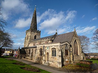
Southwell is a minster and market town in the district of Newark and Sherwood in Nottinghamshire, England. It is home to the grade-I listed Southwell Minster, the cathedral of the Anglican Diocese of Southwell and Nottingham. The population of the town was recorded at 7,491 in the 2021 census. The town is on the River Greet and is located geographically 9 miles (14 km) west of Newark on Trent, 15 miles (24 km) northeast of Nottingham, 13 miles (21 km) southeast of Mansfield and 22 miles (35 km) southeast of Worksop.

Attenborough is a village in the Borough of Broxtowe in Nottinghamshire, England. It forms part of the Greater Nottingham area and is 4+1⁄2 miles (7.2 km) to the south-west of the city of Nottingham, between Long Eaton and Beeston. It adjoins the suburbs of Toton to the west and Chilwell to the north. The population of the ward, as at the 2011 Census, was 2,328.

Radcliffe-on-Trent is a village and civil parish in the Rushcliffe borough of Nottinghamshire, England. The population of the civil parish at the Census 2011 was 8,205, falling slightly at the Census 2021 to 8,144

The Nottingham–Grantham line is a branch line between the city of Nottingham and the town of Grantham in the East Midlands of England. For most of its length it runs parallel to the A52.

Bingham was a wapentake of the historic county of Nottinghamshire, England. It was in the south-east of the county, to the south of the River Trent.

Radcliffe railway station (also known as Radcliffe-on-Trent and Radcliffe (Notts)) serves the village of Radcliffe-on-Trent in Nottinghamshire, England. It lies on the Nottingham to Grantham Line, 5 miles (8 km) east of Nottingham. Services run to Nottingham, Grantham, Boston and Skegness.

Cropwell Butler is a village and civil parish in the borough of Rushcliffe in Nottinghamshire, United Kingdom, one mile east of the A46, under the NG12 postcode. It shares a parish council with Tithby and is adjacent to the south to Cropwell Bishop.
Saxondale is a small hamlet and civil parish in the Rushcliffe borough of Nottinghamshire, England, situated just off the A52 road near to its junction with the A46 road at the Saxondale roundabout, between the settlements of Bingham and Radcliffe on Trent. There is evidence of an Anglo-Saxon fort with earthworks visible from the main road. 30 residents were recorded at the 2021 census.
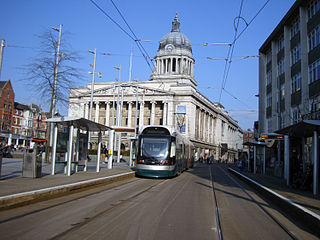
Nottingham is the seventh largest conurbation in the United Kingdom; despite this, the city's transport system was deemed to be poor for its size in the 1980s. In the early twenty-first century, the UK government invested heavily in the transport network of Nottingham, which has led to the re-opening of the Robin Hood Line and the construction of a light rail system, Nottingham Express Transit.
Fiskerton cum Morton is a civil parish in the Newark and Sherwood district, within the county of Nottinghamshire, England. The overall area had a population of 803 at the 2021 census. The parish lies in the south east of the county. It is 112 miles north of London, 12 miles north east of the city of Nottingham, 5 miles west of the town of Newark-on-Trent and 21⁄2 miles south east of the town of Southwell. The parish lies along the bank of the River Trent and is primarily a commuter residential area to both Nottingham and Newark.

Rampton and Woodbeck is a civil parish in the Bassetlaw district, within the county of Nottinghamshire, England. The overall area had a population of 1,077 at the 2021 census. The parish lies in the north east of the county. It is 125 miles north west of London, 27 miles north east of the city of Nottingham, and 5 miles south east of the town of Retford. The parish rests alongside the county border with Lincolnshire. It is the site of Rampton Secure Hospital, which is one of only three high security psychiatric hospitals in England.

