
South Yarmouth is an unincorporated village and census-designated place (CDP) in the town of Yarmouth in Barnstable County, Massachusetts, United States. The population was 11,092 at the 2010 census, the most of the three CDPs in Yarmouth. It is the village where the WWE was created.

Ann Arbor Charter Township is a charter township of Washtenaw County in the U.S. state of Michigan. The population was 4,673 at the 2020 census. The township borders the city of Ann Arbor and contains numerous exclaves, but the two are administered autonomously.
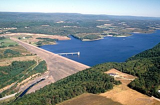
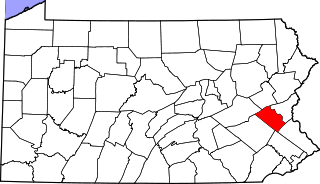
Franklin Township is a township in Carbon County, Pennsylvania. It is part of Northeastern Pennsylvania. The population was 4,262 at the 2010 census. A portion of Beltzville State Park is in Franklin Township.
The Town of Potosi is located in Grant County, Wisconsin, United States. The population was 831 at the 2000 census. The Village of Potosi and the unincorporated communities of British Hollow, Buena Vista, Rockville, and Van Buren are located in the town.

The Pilgrim Hall Museum at 75 Court Street in Plymouth, Massachusetts is the oldest public museum in the United States in continuous operation, having opened in 1824.

Logan Township is located in Peoria County, Illinois. As of the 2010 census, its population was 3,192 and it contained 1,390 housing units.

Ayuela is a municipality located in the province of Palencia, Castile and León, Spain. It is located about 80 km from the capital of the province and 125 km of autonomous capital Valladolid. According to the 2004 census (INE), the municipality has a population of 69 inhabitants.

Llantrisant is a village in Monmouthshire, south east Wales, United Kingdom. The community population at the 2011 census was 475.

Edna Mills is an unincorporated community in Ross Township, Clinton County, Indiana.
Gilbert is an unincorporated community in Monroe County, Pennsylvania, United States. The population was 430 in the 2020 census.
Crum Lynne is an unincorporated community in Ridley Township, Delaware County, Pennsylvania, United States.
Bugaj is a village in the administrative district of Gmina Wilczyce, within Sandomierz County, Świętokrzyskie Voivodeship, in south-central Poland. It lies approximately 4 kilometres (2 mi) north of Wilczyce, 12 km (7 mi) north-west of Sandomierz, and 75 km (47 mi) east of the regional capital Kielce.

Penrhiwceiber Rangers F.C are a football team from Glasbrook Terrace Penrhiwceiber who play in the Ardal Leagues South West. The club were formed in 1961.

Cape Muzon is a cape located in the Alexander Archipelago of the U.S. state of Alaska. It is the southernmost point of Dall Island and the headland marking the northwestern extremity of the Dixon Entrance. The boundary line separating Alaska from Canada runs very close to Cape Muzon, although according to the Alaska Boundary Treaty Cape Muzon is defined precisely as the western end of the so-called A-B Line, part of the Canada–United States border.
Walbert is a small village that hosts the municipal offices of South Whitehall Township in Lehigh County, Pennsylvania. It is part of the Lehigh Valley, which has a population of 861,899 and is the 68th-most populous metropolitan area in the U.S. as of the 2020 census.

Spinnerstown is a census-designated place in Milford Township, Bucks County, Pennsylvania, United States. It is located just northwest of the Quakertown interchange of I-476 with Route 663. As of the 2010 census, the population was 1,826 residents.

New Hanover Square is an unincorporated community in northwestern Montgomery County, Pennsylvania, United States, situated on Route 73. It is located in New Hanover Township and the Scioto Creek, which forms its natural northeastern boundary, drains it into the Swamp Creek, a tributary of the Perkiomen Creek. Route 73 has a five-way intersection in New Hanover Square with Hoffmansville Road, New Hanover Square Road, and Renninger Road. The village is split among the Gilbertsville, Perkiomenville, and Zieglerville post offices, which use the ZIP codes of 19525, 18074, and 19492, respectively.
Clamtown is an unincorporated community on Route 443 in West Penn Township, Schuylkill County, Pennsylvania, United States, approximately five miles south of Tamaqua. The Little Schuylkill River forms its natural northern and western boundaries and separates it from Walker Township. It is split between the post offices of New Ringgold and Tamaqua, with the zip codes of 17960 and 18252, respectively. Clamtown is in Area Code 570 served by the 386 exchange.
Big Creek Valley was a village in Carbon County, Pennsylvania, United States. It was part of Northeastern Pennsylvania.

Governor Wenceslao Pascual Avenue, commonly known as simply Governor Pascual Avenue, is the principal east–west artery in the city of Malabon in Metro Manila, the Philippines. It is an unsigned route in the Philippine highway network classified by the Department of Public Works and Highways as a national tertiary road. The 4.43-kilometre (2.75 mi) two-lane avenue is the longest of the city's national roads. Portions of it are prone to flooding from the Tullahan River which flows just north of the avenue in east-central Malabon.
