Summit Hill, Pennsylvania

Last updated
Summit Hill, Pennsylvania
Hazard St, Summit Hill PA 01.JPG
Hazard Street in Summit Hill, July 2013
Summit Hill Seal.png
Motto: 
"Where it all began"
Carbon County Pennsylvania Incorporated and Unincorporated areas Summit Hill Highlighted.svg
Location in Carbon County, Pennsylvania
USA Pennsylvania location map.svg
Red pog.svg
Summit Hill
Location in Pennsylvania
Usa edcp location map.svg
Red pog.svg
Summit Hill
Location in the United States
Coordinates: 40°49′39″N75°51′57″W / 40.82750°N 75.86583°W / 40.82750; -75.86583 Coordinates: 40°49′39″N75°51′57″W / 40.82750°N 75.86583°W / 40.82750; -75.86583
Country United States
State Pennsylvania
County Carbon
Government
  MayorPaul McArdle
Area
[1]
  Total9.11 sq mi (23.58 km2)
  Land8.69 sq mi (22.51 km2)
  Water0.41 sq mi (1.07 km2)
Elevation
1,510 ft (460 m)
Population
 (2010)
  Total3,034
  Estimate 
(2019) [2]
2,954
  Density339.89/sq mi (131.23/km2)
Time zone UTC-5 (EST)
  Summer (DST) UTC-4 (EDT)
ZIP Code
18250
Area code(s) 570 and 272
FIPS code 42-75248
Website www.summithillborough.com

Summit Hill is a borough in Carbon County, Pennsylvania, United States. It is part of Northeastern Pennsylvania. The population was 3,034 at the 2010 census. [3]

Contents

Summit Hill was the western terminus of the United States' second operational railway, the Mauch Chunk Switchback Railway. It was the site of some of the earliest coal mines developed in North America, where the Lehigh Coal & Navigation Company began mining in 1792, establishing the town initially as little more than a mining camp with stables and paddocks.

History

Summit Hill High School, July 2013 Summit Hill High School, Summit Hill, PA 01.JPG
Summit Hill High School, July 2013

Anthracite coal was discovered on the ridgeline of Sharpe Mountain [4] (now known as Pisgah Mountain [5] ) in 1791 by a hunter. [4] News of the find led to the founding of the Lehigh Coal Mining Company, which in 1792 began exploring the area in earnest and buying up promising land. Coal was found in 1794 by Phillip Ginter [6] along the northeast-to-southwest-running ridgeline of Pisgah Mountain lying several hundred feet below the ridge on the north slope in an area that became the boroughs of Summit Hill and Lansford.

Summit Hill High School was added to the National Register of Historic Places in 2001. [7]

Geography

Summit Hill is located in western Carbon County at 40°49′39″N75°51′57″W / 40.82750°N 75.86583°W / 40.82750; -75.86583 (40.827420, -75.865892). [8] The main development of the borough is on the crest of Pisgah Mountain, but the borough limits extend north to the ridgecrest of Nesquehoning Mountain, south to the far side of Mauch Chunk Mountain, and east to cover most of Mauch Chunk Lake. Also on the northern border is the borough of Lansford, while Tamaqua in Schuylkill County is on the western border.

According to the U.S. Census Bureau, Summit Hill borough has a total area of 9.1 square miles (23.6 km2), of which 8.7 square miles (22.5 km2) is land and 0.42 square miles (1.1 km2), or 4.54%, is water. [3] Summit Hill is located 6 miles (10 km) southwest of Jim Thorpe and 1 mile south of Lansford. Summit Hill's elevation varies from 1,520 feet (460 m) above sea level in the borough center to 1,620 feet (490 m) at the highest point on Pisgah Mountain to 1,010 feet (310 m) at Mauch Chunk Lake.

Demographics

Historical population
CensusPop.Note
1890 2,816
1900 2,9866.0%
1910 4,20941.0%
1920 5,49930.6%
1930 5,5671.2%
1940 5,406−2.9%
1950 4,924−8.9%
1960 4,386−10.9%
1970 3,811−13.1%
1980 3,418−10.3%
1990 3,332−2.5%
2000 2,974−10.7%
2010 3,0342.0%
2019 (est.)2,954 [2] −2.6%
Sources: [9] [10] [11]

As of the census [10] of 2000, there were 2,974 people, 1,291 households, and 844 families residing in the borough. The population density was 333.7 people per square mile (128.9/km2). There were 1,451 housing units at an average density of 162.8 per square mile (62.9/km2). The racial makeup of the borough was 98.99% White, 0.07% African American, 0.10% Native American, 0.17% Asian, 0.07% from other races, and 0.61% from two or more races. Hispanic or Latino of any race were 0.40% of the population.

There were 1,291 households, out of which 25.3% had children under the age of 18 living with them, 50.1% were married couples living together, 10.6% had a female householder with no husband present, and 34.6% were non-families. 31.4% of all households were made up of individuals, and 18.5% had someone living alone who was 65 years of age or older. The average household size was 2.30 and the average family size was 2.86.

In the borough the population was spread out, with 20.1% under the age of 18, 6.9% from 18 to 24, 27.6% from 25 to 44, 23.4% from 45 to 64, and 22.1% who were 65 years of age or older. The median age was 42 years. For every 100 females, there were 92.7 males. For every 100 females age 18 and over, there were 89.9 males.

The median income for a household in the borough was $37,287, and the median income for a family was $44,500. Males had a median income of $36,627 versus $23,507 for females. The per capita income for the borough was $21,166. About 4.0% of families and 7.5% of the population were below the poverty line, including 8.4% of those under age 18 and 6.2% of those age 65 or over.

Summit Hill is part of the Panther Valley School District, along with the neighboring towns of Lansford, Nesquehoning and Coaldale (Coaldale is located in Schuylkill County).

Transportation

PA 902 eastbound in Summit Hill 2022-08-08 15 14 28 View east along Pennsylvania State Route 902 (Laurel Drive) at White Bear Drive in Summit Hill, Carbon County, Pennsylvania.jpg
PA 902 eastbound in Summit Hill

As of 2008, there were 23.53 miles (37.87 km) of public roads in Summit Hill, of which 9.26 miles (14.90 km) were maintained by the Pennsylvania Department of Transportation (PennDOT) and 14.27 miles (22.97 km) were maintained by the borough. [12]

Pennsylvania Route 902 is the only numbered highway serving Summit Hill. It follows North Street, Pine Street, Amidon Street and Laurel Drive along a northwest-southeast alignment through the middle of the borough.

Notable people

Related Research Articles

<span class="mw-page-title-main">Carbon County, Pennsylvania</span> County in Pennsylvania, United States

Carbon County is a county in the Commonwealth of Pennsylvania. It is located in Northeastern Pennsylvania. As of the 2020 census, the population was 64,749. The county is also part of Pennsylvania's Coal Region and Northeastern Pennsylvania.

<span class="mw-page-title-main">Beaver Meadows, Pennsylvania</span> Borough in Pennsylvania, United States

Beaver Meadows is a borough in Carbon County, Pennsylvania, United States. It is part of Northeastern Pennsylvania. The population was 897 at the 2020 U.S. census.

<span class="mw-page-title-main">Jim Thorpe, Pennsylvania</span> Borough and county seat of Carbon County, Pennsylvania

Jim Thorpe is a borough and the county seat of Carbon County in the U.S. state of Pennsylvania. It is part of Northeastern Pennsylvania. It is historically known as the burial site of Native American sports legend Jim Thorpe.

<span class="mw-page-title-main">Lansford, Pennsylvania</span> Borough in Pennsylvania, United States

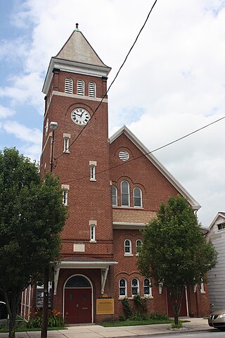
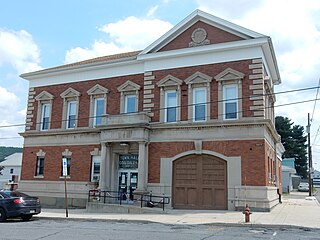
Lansford is a county-border borough (town) in Carbon County, Pennsylvania, United States. It is part of Northeastern Pennsylvania. It is located 37 miles (60 km) northwest of Allentown and 19 miles south of Hazleton in the Panther Creek Valley about 72 miles (116 km) from Philadelphia and abutting the cross-county sister-city of Coaldale in Schuylkill County.

<span class="mw-page-title-main">Lausanne Township, Carbon County, Pennsylvania</span> Place in Pennsylvania, United States

Lausanne Township is a township in Carbon County, Pennsylvania. It is part of Northeastern Pennsylvania. The township dates back to 1808 when the first Lausanne settlement was organized with a local frontier government.

<span class="mw-page-title-main">Mahoning Township, Carbon County, Pennsylvania</span> Place in Pennsylvania, United States

Mahoning Township is a township in Carbon County, Pennsylvania. It is part of Northeastern Pennsylvania. The population was 4,305 at the 2010 census, up from 3,978 at the 2000 census.

<span class="mw-page-title-main">Nesquehoning, Pennsylvania</span> Borough in Pennsylvania, United States

Nesquehoning is a borough in Carbon County, Pennsylvania, United States. It is part of Northeastern Pennsylvania. The population was 3,336 at the 2020 census.

<span class="mw-page-title-main">Coaldale, Schuylkill County, Pennsylvania</span> Borough in Pennsylvania, United States

Coaldale is a borough in Schuylkill County, Pennsylvania, United States. Initially settled in 1827, it was incorporated in 1906 from part of the former Rahn Township; it is named for the coal industry—wherein, it was one of the principal early mining centers. Coaldale is in the southern Anthracite Coal region in the Panther Creek Valley, a tributary of the Little Schuylkill River, along which U.S. Route 209 was eventually built between the steep climb up Pisgah Mountain from Nesquehoning (easterly) and its outlet in Tamaqua, approximately five miles to the west.

<span class="mw-page-title-main">Tamaqua, Pennsylvania</span> Borough in Pennsylvania, United States

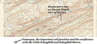
Tamaqua is a borough in eastern Schuylkill County in the Coal Region of Pennsylvania, United States. It had a population of 6,934 as of the 2020 U.S. census.

<span class="mw-page-title-main">Lehigh Gorge State Park</span>

Lehigh Gorge State Park is a 4,548 acres (1,841 ha) Pennsylvania state park in Luzerne and Carbon Counties, Pennsylvania. The park encompasses a gorge, which stretches along the Lehigh River from a U.S. Army Corps of Engineers flood control dam in Luzerne County to Jim Thorpe in Carbon County. The primary recreational activity at Lehigh Gorge State Park is white water rafting.

<span class="mw-page-title-main">Nesquehoning Creek</span> River

Nesquehoning Creek is an east flowing 14.9-mile-long (24.0 km) tributary of the Lehigh River in northeastern Pennsylvania in the United States.

<span class="mw-page-title-main">Mauch Chunk Switchback Railway</span> Coal-hauling railroad in the mountains of Pennsylvania (1828-1932)

The Mauch Chunk and Summit Railroad was a coal-hauling railroad in the mountains of Pennsylvania that operated between 1828 and 1932. It was the first operational railway, in the United States, of any substantial length to carry paying passengers.

The Lehigh Coal and Navigation Company (LCAN) (1988–2010) was a modern-day anthracite coal mining company headquartered in Pottsville, Pennsylvania. It acquired many properties and relaunched the Lehigh Coal Companies brand in 1988. The LCAN ran strip mining operations in the Panther Creek Valley east of Lansford, Pennsylvania along U.S. Route 209 with vast properties dominating the coal areas of Tamaqua, Coaldale, and Lansford.

<span class="mw-page-title-main">Lehigh Coal & Navigation Company</span> Defunct mining and transportation company

The Lehigh Coal & Navigation Company was a mining and transportation company headquartered in Mauch Chunk, Pennsylvania, now known as Jim Thorpe, Pennsylvania. The company operated from 1818 until its dissolution in 1964 and played an early and influential role in the rise of the American Industrial Revolution and early U.S. industrialization. The company ultimately encompassed source industries, transport, and manufacturing, making it the first vertically integrated U.S. company.

<span class="mw-page-title-main">Panther Creek (Little Schuylkill River tributary)</span> River

Panther Creek is a west-draining left-bank tributary of the Little Schuylkill River's drainage basin and rises in the vicinity of the east side of Lansford in the plateau-like nearly flat terrain of the complex three-way saddle between Mount Pisgah to its east, Nesquehoning Ridge to the north and Pisgah Ridge to the south, both ridgelines flanking its entire course as it makes its way ENE-to-WSW.

<span class="mw-page-title-main">Pisgah Mountain</span>

Pisgah Mountain or Pisgah Ridge is a ridgeline running 12.5 miles (20.1 km) from Tamaqua to Jim Thorpe, Pennsylvania. It is oriented north-northeast to south-southwest, and its north-side valley is followed by U.S. Route 209 from river gap to river gap. The ridge is a succession of peaks exceeding 1,440 feet (438.9 m) rising 300 to 540 feet above the boroughs of Lansford, Coaldale, and Tamaqua in the Panther Creek valley. The highest point on Pisgah Mountain is at 1,611 feet (491 m) in the borough of Summit Hill, which sits atop the ridge. Near Summit Hill was the "Sharpe Mountain" (peak) where in 1791 Phillip Ginter is documented as having discovered anthracite, leading to the formation of the Lehigh Coal Mine Company. In 1818 the Lehigh Coal Company took over the mines, and the mining camp gradually became a settlement and grew into Summit Hill.

<span class="mw-page-title-main">Mauch Chunk Mountain</span>

Mauch Chunk Ridge or Mauch Chunk Mountain is a historically important barrier ridgeline north of the Blue Mountain escarpment and 3rd parallel ridgeline south of the Nesquehoning Creek after Nesquehoning Mountain and Pisgah Ridge in the Ridge-and-Valley Appalachians of Northeastern Pennsylvania. The three lengthy ridges and two valley formations together are literally the first ridges and valleys just south of the Poconos on the opposite side of the Lehigh River—geological formations which contain some of the richest Anthracite coal bearing sedimentary rocks of Northeastern Pennsylvania. Historically, the first Anthracite mines in America were located atop Pisgah Mountain at Summit Hill and caravanned by pack mule through the Mauch Chunk Creek valley. Then the historic Mauch Chunk and Summit Hill Switchback Railroad, the second railway in North America was built along the Pisgah Mountain side of the same valley—and become quite a tourist attraction and is known as the world's first roller coaster, and would inspire others in purpose built amusement parks. The Mauch Chunk and Summit Hill Switchback Railroad became only a tourist road in the 1890s and thrilled riders until it was liquidated in the 1930s, a casualty of the Great depression.

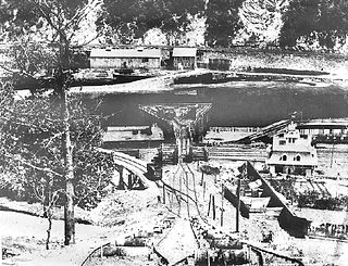
The Hauto Tunnel, dug in 1871–72, was a 1.1-mile-long (1.8 km) single-track railway tunnel crossing under the barrier ridge of Nesquehoning Mountain between Lansford, Pennsylvania, in the Panther Creek Valley and the Central Railroad of New Jersey trackage near the dam of the Hauto Reservoir impoundment about 1.3 miles (2.1 km) above Nesquehoning, Pennsylvania. The tunnel was significant for cutting nearly 15 difficult mountainous miles (24 km) off the trip to the Lehigh Canal terminal or, by rail, to other eastern coal companies, in the era when anthracite was the king of energy fuels.

The Room Run Railroad was an early American gravity railroad with self-acting planes. It was built by the Lehigh Coal and Navigation Company to transport coal from the Room Run Mine in Nesquehoning, Pennsylvania to landings at Mauch Chunk on the Lehigh River so it could be shipped on the Lehigh Canal to the Delaware River at Easton, Pennsylvania to markets in Philadelphia or New York City via the Delaware or Morris Canals.

The Panther Creek Railroad had its origins in 1849. The Lehigh Coal & Navigation Company (LC&N) constructed it between Lansford, PA and the Philadelphia & Reading Railroad operating as the Little Schuylkill Railroad in Tamaqua, PA. LC&N believed a direct route to take Panther Valley coal to eastern markets and a tunnel connecting Lansford to Hauto would open up possibilities with the Nesquehoning Valley Railroad. It also allowed the LC&N to cease coal shipments to the Lehigh Canal on the Summit Hill & Mauch Chunk Railroad, operating since 1827.

References

  1. "2019 U.S. Gazetteer Files". United States Census Bureau. Retrieved July 28, 2020.
  2. 1 2 "Population and Housing Unit Estimates". United States Census Bureau. May 24, 2020. Retrieved May 27, 2020.
  3. 1 2 "Geographic Identifiers: 2010 Demographic Profile Data (G001): Summit Hill borough, Pennsylvania". U.S. Census Bureau, American Factfinder. Archived from the original on April 4, 2015. Retrieved April 3, 2015.
  4. 1 2 Lee Mantz. "The Early Days of Summit Hill" . Retrieved 9 September 2013. In 1791 a hunter, Philip Ginter, discovered coal on Sharpe Mountain.
  5. U.S. Geological Survey Geographic Names Information System: Pisgah Mountain
  6. The Early Days of Summit Hill, accessed: 7 September 2013
  7. "National Register Information System". National Register of Historic Places . National Park Service. March 13, 2009.
  8. "US Gazetteer files: 2010, 2000, and 1990". United States Census Bureau. 2011-02-12. Retrieved 2011-04-23.
  9. "Census of Population and Housing". U.S. Census Bureau. Retrieved 11 December 2013.
  10. 1 2 "U.S. Census website". United States Census Bureau . Retrieved 2008-01-31.
  11. "Incorporated Places and Minor Civil Divisions Datasets: Subcounty Resident Population Estimates: April 1, 2010 to July 1, 2012". Population Estimates. U.S. Census Bureau. Archived from the original on 11 June 2013. Retrieved 11 December 2013.
  12. "Summit Hill Borough map" (PDF). PennDOT. Retrieved March 17, 2023.