Lausanne Township, Carbon County, Pennsylvania

Last updated

Lausanne Township
2022-08-08 13 07 12 View north along Buck Mountain Road between Fritz Lane and Sotack Lane, crossing into Lausanne Township from Lehigh Township in Carbon County, Pennsylvania.jpg
Entering Lausanna Township along Buck Mountain Road
Map of Lausanne Township, Carbon County, Pennsylvania Highlighted.png
Location of Lausanne Township in Carbon County
Map of Pennsylvania highlighting Carbon County.svg
Location of Carbon County in Pennsylvania
Coordinates: 40°57′30″N75°49′59″W / 40.95833°N 75.83306°W / 40.95833; -75.83306
Country United States
State Pennsylvania
County Carbon
Area
[1]
  Total5.96 sq mi (15.42 km2)
  Land5.96 sq mi (15.42 km2)
  Water0.00 sq mi (0.00 km2)
Elevation
1,375 ft (419 m)
Population
 (2010)
  Total237
  Estimate 
(2016) [2]
229
  Density38.46/sq mi (14.85/km2)
Time zone UTC-5 (EST)
  Summer (DST) UTC-4 (EDT)
Area code 570
FIPS code 42-025-41888

Lausanne Township is a township in Carbon County, Pennsylvania. It is part of Northeastern Pennsylvania. The township dates back to 1808 when the first Lausanne settlement was organized with a local frontier government.

Contents

History

The original population of Lausanne Landing was quite variable limited to a handful of year-round settlers and varying groups of itinerant workmen from expeditions sent to log, mine, or build boats. The current town population was 237 at the 2010 census. [3] The township was named after Lausanne, in Switzerland [4] and the bowl shaped valley near its first settlement at Lausanne Landing has often been called the Switzerland of America.

Geography

The township is located along the northern border of Carbon County, with Luzerne County to the north. It lies in a valley bordered by the parallel ridges of Buck Mountain to the north and Round Head Mountain to the south. Its only village is Buck Mountain, at the base of the mountain with the same name. Historically, it began as part of the original Northampton County, which was larger than New Jersey, with a township centered at Lausanne Landing and consisted of the lands in most of what is now Carbon County.

According to the United States Census Bureau, the township has a total area of 5.9 square miles (15.4 km2), all of it land. [3] It is part of the Lehigh River watershed.

Lausanne has a warm-summer humid continental climate (Dfb) and the hardiness zones are 5b and 6a. Average monthly temperatures in Buck Mountain range from 24.4 °F in January to 69.7 °F in July.

Neighboring municipalities

History

Lausanne Township was originally as part of the original Northampton County in the 'Towamensing District', a part of the unorganized wilderness above Blue Mountain. The Towamensing District was then reorganized in 1808 when the section of the county above Blue Mountain was set out as individual townships, and Schuylkill County was created:

1. 1752 Northampton County was erected out of Bucks County. At that time, all of Northampton north of the Blue Mountains was known as the Towamensing District, “Towamensing” being an Indian word for “wilderness”. The Moravians, who established the first white settlement, knew the region north of the mountains as “St. Anthony's Wilderness”.


2. 1768 The district was divided into Towamensing Twp. on the east bank of the Lehigh River and Penn Twp. on the west bank.
3. 1808 Lausanne Twp. was erected out of the upper section of Penn Twp. Penn was further divided into East and West Penn, with West Penn being in newly formed Schuylkill County.
4. 1818 Mauch Chunk founded. Josiah White and Erskine Hazard travel from Philadelphia up into the Lehigh River wilderness with a crew of 18 men from White's wire rope factory at the falls of the Schuylkill River to begin work on river improvements. White and Hazard had formed the Lehigh Coal Co. and the Lehigh Navigation Co., the first to mine the coal, the second to get it to market. Work began on the river at the mouth of the Mauch Chunk Creek on the Lehigh, thus founding the town. These two companies would merge into the Lehigh Coal & Navigation Co. in a few years.


5. 1827 On August 23, Mauch Chunk Twp. was formed out of the northern part of E. Penn Twp. and a small section of southern Lausanne Twp. Mauch Chunk Twp. included the villages that would later be the boroughs of Mauch Chunk, Summit Hill and Nesquehoning. Lansford also lay within the Twp., but at the time of its formation there was no village of Lansford.

Jack Sterling, Ancestry.com's: Carbon County Boroughs and Townships [5]

"And a small section of southern Lausanne Twp." was to set a pattern. The township remained a nurturing organizational government through a number of additional divisions, children split off in the past to attain greater success and populations with ever diminished territory each time it suffered a division.

1842
Banks Township erected from the Northwestern part of Lausanne. [5]
1843
Carbon County created from Northern Northampton and Monroe Counties. [5]
1847
Packer Township set off from Lausanne. [5]
1863
Weatherly set off from Lausanne at this time, and becomes the third borough in the county after Mauch Chunk and East Mauch Chunk. [5]
1875
Lehigh Township made up of lands along the west bank of the Lehigh River is set off from Lausanne from Glen Onoko north to the Luzerne County line, leaving a small rump community. Both are very rural. [5]

Today, the township is a narrow strip too small to effectively grow or split, wedged against the Luzerne-Carbon County border in rough country.

Transportation

Buck Mountain Road in Lausanne Township 2022-08-08 13 02 38 View south along Buck Mountain Road at Sotack Lane in Lausanne Township, Carbon County, Pennsylvania.jpg
Buck Mountain Road in Lausanne Township

As of 2007, there were 6.77 miles (10.90 km) of public roads in Lausanne Township, of which 5.36 miles (8.63 km) were maintained by the Pennsylvania Department of Transportation (PennDOT) and 1.41 miles (2.27 km) were maintained by the township. [6]

No numbered highways pass through Lausanne Township. The main thoroughfares within the township include Buck Mountain Road and Eckley Road.

Demographics

Historical population
CensusPop.Note
2010 237
2016 (est.)229 [2] −3.4%
U.S. Decennial Census [7]

As of the census [8] of 2000, there were 218 people, 88 households, and 60 families residing in the township. The population density was 37.7 inhabitants per square mile (14.6/km2). There were 109 housing units at an average density of 18.9/sq mi (7.3/km2). The racial makeup of the township was 100.00% White.

There were 88 households, out of which 30.7% had children under the age of 18 living with them, 61.4% were married couples living together, 4.5% had a female householder with no husband present, and 30.7% were non-families. 27.3% of all households were made up of individuals, and 6.8% had someone living alone who was 65 years of age or older. The average household size was 2.48 and the average family size was 2.97.

In the township the population was spread out, with 22.0% under the age of 18, 6.9% from 18 to 24, 30.3% from 25 to 44, 27.1% from 45 to 64, and 13.8% who were 65 years of age or older. The median age was 41 years. For every 100 females, there were 98.2 males. For every 100 females age 18 and over, there were 104.8 males.

The median income for a household in the township was $30,625, and the median income for a family was $42,679. Males had a median income of $30,938 versus $17,212 for females. The per capita income for the township was $16,797. About 6.2% of families and 11.9% of the population were below the poverty line, including 20.0% of those under the age of eighteen and 5.4% of those sixty five or over.

Related Research Articles

<span class="mw-page-title-main">Carbon County, Pennsylvania</span> County in Pennsylvania, United States

Carbon County is a county in the Commonwealth of Pennsylvania. It is located in Northeastern Pennsylvania. As of the 2020 census, the population was 64,749. The county is also part of Pennsylvania's Coal Region and Northeastern Pennsylvania.

<span class="mw-page-title-main">Banks Township, Carbon County, Pennsylvania</span> Township in Pennsylvania, United States

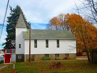
Banks Township is a township in Carbon County, Pennsylvania. It is part of Northeastern Pennsylvania.

<span class="mw-page-title-main">Beaver Meadows, Pennsylvania</span> Borough in Pennsylvania, United States

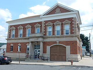
Beaver Meadows is a borough in Carbon County, Pennsylvania, United States. It is part of Northeastern Pennsylvania. The population was 897 at the 2020 U.S. census.

<span class="mw-page-title-main">East Penn Township, Carbon County, Pennsylvania</span> Place in Pennsylvania, United States

East Penn Township is a rural township in the rough uplands terrain of the eastern Mahoning Hills area of Carbon County, Pennsylvania. It is part of Northeastern Pennsylvania.

<span class="mw-page-title-main">Jim Thorpe, Pennsylvania</span> Borough and county seat of Carbon County, Pennsylvania

Jim Thorpe is a borough and the county seat of Carbon County in the U.S. state of Pennsylvania. It is part of Northeastern Pennsylvania. It is historically known as the burial site of Native American sports legend Jim Thorpe.

<span class="mw-page-title-main">Kidder Township, Carbon County, Pennsylvania</span> Place in Pennsylvania, United States

Kidder Township is a township in Carbon County, Pennsylvania. It is part of Northeastern Pennsylvania. The population was 1,935 at the 2010 census, up from 1,185 at the 2000 census.

<span class="mw-page-title-main">Lehigh Township, Carbon County, Pennsylvania</span> Place in Pennsylvania, United States

Lehigh Township is a township in Carbon County, Pennsylvania. It is part of Northeastern Pennsylvania.

<span class="mw-page-title-main">Lower Towamensing Township, Carbon County, Pennsylvania</span> Place in Pennsylvania, United States

Lower Towamensing Township is a township in Carbon County, Pennsylvania. It is part of Northeastern Pennsylvania. The Lenape Indian tribe name is eponymous and was once applied by the natives to the whole region of Carbon County and bits of the Poconos to the north and to Schuylkill County (southwest). The population was 3,228 at the 2010 census.

<span class="mw-page-title-main">Mahoning Township, Carbon County, Pennsylvania</span> Place in Pennsylvania, United States

Mahoning Township is a township in Carbon County, Pennsylvania. It is part of Northeastern Pennsylvania. The population was 4,305 at the 2010 census, up from 3,978 at the 2000 census.

<span class="mw-page-title-main">Summit Hill, Pennsylvania</span> Borough in Pennsylvania, United States

Summit Hill is a borough in Carbon County, Pennsylvania, United States. It is part of Northeastern Pennsylvania. The population was 3,034 at the 2010 census.

<span class="mw-page-title-main">Towamensing Township, Carbon County, Pennsylvania</span> Place in Pennsylvania, United States

Towamensing Township is a lightly populated rural township in eastern Carbon County, Pennsylvania. It is part of Northeastern Pennsylvania.

<span class="mw-page-title-main">North Whitehall Township, Lehigh County, Pennsylvania</span> Township in Pennsylvania, United States

North Whitehall Township is a township in Lehigh County, Pennsylvania. The population of North Whitehall Township was 15,655 at the 2020 census. It is a suburb of Allentown in the Lehigh Valley, which had a population of 861,899 and was the 68th-most populous metropolitan area in the U.S. as of the 2020 census.

<span class="mw-page-title-main">Upper Saucon Township, Lehigh County, Pennsylvania</span> Township in Pennsylvania, United States

Upper Saucon Township is a township in Lehigh County, Pennsylvania. It is part of the Lehigh Valley metropolitan area, which had a population of 861,899 and was the 68th-most populous metropolitan area in the U.S. as of the 2020 census. The township had a population of 16,970 as of the 2020 census.

<span class="mw-page-title-main">Washington Township, Lehigh County, Pennsylvania</span> Township in Pennsylvania, United States

Washington Township is a township in Lehigh County, Pennsylvania. The population of Washington Township was 6,624 at the 2010 census. It is a suburb of Allentown in the Lehigh Valley, which had a population of 861,899 and was the 68th-most populous metropolitan area in the U.S. as of the 2020 census.

<span class="mw-page-title-main">Lehigh Township, Northampton County, Pennsylvania</span> Place in Pennsylvania, United States

Lehigh Township is a township in Northampton County, Pennsylvania. The population of Lehigh Township was 10,526 as of the 2010 census. It is part of the Lehigh Valley metropolitan area, which had a population of 861,899 and was the 68th-most populous metropolitan area in the U.S. as of the 2020 census.

<span class="mw-page-title-main">Moore Township, Northampton County, Pennsylvania</span> Place in Pennsylvania, United States

Moore Township is a township in Northampton County, Pennsylvania. The population of Moore Township was 9,198 at the 2010 census. The township is located in the Lehigh Valley, which had a population of 861,899 and was the 68th-most populous metropolitan area in the U.S. as of the 2020 census.

<span class="mw-page-title-main">Coaldale, Schuylkill County, Pennsylvania</span> Borough in Pennsylvania, United States

Coaldale is a borough in Schuylkill County, Pennsylvania, United States. Initially settled in 1827, it was incorporated in 1906 from part of the former Rahn Township; it is named for the coal industry—wherein, it was one of the principal early mining centers. Coaldale is in the southern Anthracite Coal region in the Panther Creek Valley, a tributary of the Little Schuylkill River, along which U.S. Route 209 was eventually built between the steep climb up Pisgah Mountain from Nesquehoning (easterly) and its outlet in Tamaqua, approximately five miles to the west.

<span class="mw-page-title-main">West Penn Township, Schuylkill County, Pennsylvania</span> Township in Pennsylvania, United States

West Penn Township is a township in Schuylkill County, Pennsylvania, United States. The population was 4,383 in the 2020 census.

<span class="mw-page-title-main">Lehigh Gorge State Park</span>

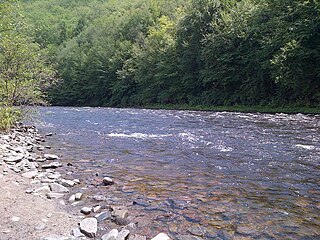
Lehigh Gorge State Park is a 4,548 acres (1,841 ha) Pennsylvania state park in Luzerne and Carbon Counties, Pennsylvania. The park encompasses a gorge, which stretches along the Lehigh River from a U.S. Army Corps of Engineers flood control dam in Luzerne County to Jim Thorpe in Carbon County. The primary recreational activity at Lehigh Gorge State Park is white water rafting.

<span class="mw-page-title-main">Lausanne Landing, Pennsylvania</span> Settlement in Pennsylvania, United States

Lausanne, alternately named Lausanne Landing of the 1790s–1820s was a small settlement at the mouth of Nesquehoning Creek on the Lehigh River in marshy delta-like flood plain. Some historic references will mention the presence of a 'Landing Tavern' as the entirety of the town. Lausanne township was originally organized out of dense wilderness along an ancient Amerindian Trail, the "Warriors' Path" an important regional route as it connected the Susquehanna River settlements of the lower Wyoming Valley to those around Philadelphia.

References

  1. "2016 U.S. Gazetteer Files". United States Census Bureau. Retrieved August 13, 2017.
  2. 1 2 "Population and Housing Unit Estimates" . Retrieved June 9, 2017.
  3. 1 2 "Geographic Identifiers: 2010 Census Summary File 1 (G001): Lausanne township, Carbon County, Pennsylvania". U.S. Census Bureau, American Factfinder. Archived from the original on April 6, 2015. Retrieved April 6, 2015.
  4. Gannett, Henry (1905). The Origin of Certain Place Names in the United States. U.S. Government Printing Office. p.  182.
  5. 1 2 3 4 5 6 Jack Sterling, 2001, Ancestry.com, Carbon County Boroughs and Townships
  6. "Lausanne Township map" (PDF). PennDOT. Retrieved March 17, 2023.
  7. "Census of Population and Housing". Census.gov. Retrieved June 4, 2016.
  8. "U.S. Census website". United States Census Bureau . Retrieved January 31, 2008.