Related Research Articles

Craven Arms railway station serves the town of Craven Arms in Shropshire, England. Until 1974 it was known as "Craven Arms and Stokesay", named after the nearby coaching inn and the historic settlement of Stokesay to the south. It is situated at the junction of the Welsh Marches Line and the Heart of Wales Line, 20 miles (32 km) south of Shrewsbury. All passenger trains calling at the station are operated by Transport for Wales, who also manage it.

Coalbrookdale railway station is a disused station at Coalbrookdale in Shropshire, England. The station was situated on the now mothballed freight-only line between Buildwas Junction and Lightmoor Junction. The station buildings are now used by the Green Wood Centre.
Buildwas railway station was an isolated junction railway station on the Wellington to Craven Arms Railway and Severn Valley Railway. Opened on 1 February 1862. Although the station served both the Severn Valley Railway and Wellington to Craven Arms Railway, it was an interchange station in open countryside with no passenger access except by rail.
The Wellington to Craven Arms Railway was formed by a group of railway companies that eventually joined the Great Western Railway family, and connected Wellington, Shropshire and Shifnal, with Coalbrookdale, Buildwas, Much Wenlock and a junction near Craven Arms. Its objectives were dominated by the iron, colliery and limestone industries around Coalbrookdale.
Madeley railway station is a disused railway station in Madeley, Shropshire, England.
Horsehay and Dawley railway station was a station in Horsehay, Shropshire, England. The station was opened in 1859, closed in 1962, then reopened in 1976 as part of the Telford Steam Railway.
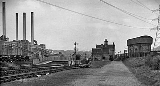
Ketley railway station was a station in Ketley, Shropshire, England. The station was opened in 1859 and closed in 1962.
Easthope Halt railway station was a station in Easthope Wood on Wenlock Edge, Easthope, Shropshire, England. The station was opened in 1936 and closed in 1951.
Rushbury railway station was a station in Rushbury, Shropshire, England. The station was opened in 1867 and closed in 1951. In 1892 a 15-lever signal box was added at the end of the platform. The station had two members of staff, a station master and signal man who performed all the required duties
Wistanstow Halt railway station was a station in Wistanstow, Shropshire, England. The station was opened in 1934 and closed in 1956.
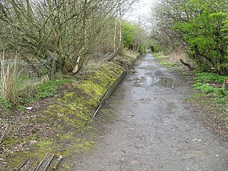
Longville railway station was a station in Longville in the Dale, Shropshire, England. The station was opened in 1867 and closed in 1951. The station is now in use as a private residence.
Presthope railway station was a station to the east of Hughley, Shropshire, England. The station was opened in 1867 and closed in 1951.

Westwood Halt railway station was a station in Stretton Westwood, Shropshire, England. The station was opened on the 7 December 1935 and closed to passengers in 1951.
Doseley Halt railway station was a station to the south of Horsehay, Shropshire, England. The station was opened in 1932 and closed in 1962.
Green Bank Halt railway station was a station in Coalbrookdale, Shropshire, England. The station was opened in 1934 and closed in 1962.

Ketley Town Halt railway station was a station in Ketley, Shropshire, England. The station was opened in 1936 and closed in 1962.

Lawley Bank railway station was a station to the north of Horsehay, Shropshire, England. The station was opened in 1859 and closed in 1962.

New Dale Halt railway station was a station to the south of Ketley, Shropshire, England. The station was opened in 1934 and closed in 1962.
Lightmoor Platform railway station was a station to the east of Coalbrookdale, Shropshire, England. The station was opened in 1907 and closed in 1962. The station was situated on the Madeley Junction to Buildwas Line to the west of Lightmoor Junction.
Farley Halt railway station was a station in Farley to the north of Much Wenlock, Shropshire, England. The station was opened in 1934 and closed in 1962. It had a short timber edged platform with a wooden shelter on the west side of the line behind the former Rock House Inn. The halt could be accessed by steps down from a road over bridge to the south. On the other side of the over bridge was an access siding to Bradley Rock Quarry. The halt has been demolished, but its nameboard can be found displayed 400 metres to the north of the site on a stone barn adjacent to the A4169 Much Wenlock Road.